Negotiating the West: A History of Wyoming Trading Posts
|
|
|
- Damon Hunt
- 6 years ago
- Views:
Transcription

1 Negotiating the West: A History of Wyoming Trading Posts Greg Pierce Prepared for the Wyoming State Historic Preservation Office Planning and Historic Context Development Program Wyoming State Parks & Cultural Resources Wyoming State Historic Preservation Office

2 I shouldered my rifle and ascended the highest mountain on foot. I reached the snow in about an hour when seating myself upon a huge fragment of granite and having full view of the country around me in a few moments was almost lost in contemplation. This said it is not a place where heroes deeds of chivalry have been achieved in the days of yore neither is a place of which bards have sung until the world knows the precise posture of every tree rock and [?] or the winding turn of every streamlet. But on the contrary those stupendous rocks whose surface is formed into irregular benches rising one above another from the vale to the snow dotted here and there with low pines and covered with green herbages intermingling with flowers with the scattered flocks of sheep and elk carelessly feeding or thoughtlessly reposing beneath the shade having providence for their founder and preserver and nature for shepherd gardener and historian. In viewing scenes like this the imagination of one unskilled in science wanders to the days of the patriarchs and after numerous conjecturings returns without any final decision wonder is put to the test but having no proof for its argument a doubt still remains but supposition steps forward and taking the place of knowledge in a few words solves the mysteries of the centuries and eras after including in such a train of reflections for about two hours I descended to the camp where I found my companions had killed a fat buck elk during my absence and some of the choicest parts of it were supported on sticks around a fire. My ramble had sharpened my appetite and the delicious savor of roasted meat soon rid my brains of romantic ideas. My comrades were men who never troubled themselves about vain and frivolous notions.. - Russell Osborne s journal entry regarding the landscape of the West. Entered near Yellowstone Lake in 1837 while trapping in the region. (Haines 1965:63) I remember as we rode by the foot of Pike s Peak, when for a fortnight we met no face of man, my companion remarked, in a tone anything but complacent, that a time would come when those plains would be a grazing country, the buffalo give place to tame cattle, houses be scattered along the water-courses, and wolves, bears, and Indians be numbered among the things that were. We condoled with each other on so melancholy a prospect but with little thought what the future had in store. We knew that there was more or less gold in the seams of those untrodden mountains; but we did not foresee that it would build cities in the West and plant hotels and gambling-houses among the haunts of the grizzly bear. We knew that a few fanatical outcasts groping their way across the plains to seek an asylum from the Gentile persecution; but we did not imagine that the polygamous hordes of Mormons would rear a swarming Jerusalem in the bosom of solitude itself. We knew that more and more, year after year, the trains of emigrant wagons would creep in slow procession towards barbarous Oregon or wild and distant California; but we did not dream how Commerce and Gold would breed nations along the Pacific; the disenchanting screech of the locomotive break the spell of the weird, mysterious mountains; women s rights invade the fastness of the Arapahoe s; and despairing savagery, assailed in front and rear, veil its scalp-locks and feathers before triumphant commonplace. We were no prophets to foresee all this; and had we foreseen it, perhaps some perverse regret might have tempered the ardor of rejoicing. - Francis Parkman lamenting the future of the West during his 1846 excursion into the American West, first published in his preface to the 1872 edition of The Oregon Trail.
3 Contents Preface Cover Image: Caravan: Trappers Crossing the River A contemporary illustration by Alfred Jacob Miller. Courtesy of the Walters Art Museum, Baltimore. Images for this text were provided by: The Allen Memorial Art Museum, the Colorado Historical Society, Colorado State University Archives, the Fort Smith Museum of History, Harper s Weekly, the Kansas City Star, the Kansas Historical Society, Dave Paulley, the Smithsonian, the Steamboat Arabia Museum, Dr. Theodore Binnema, Dr. Danny Walker, the Walters Art Museum, the White House Historical Association, the Wyoming State Historic Preservation Office, the Wyoming State Museum, and the Yale Beinecke Rare Book and Manuscript Library. Introduction: Native Americans, Trade, and European Technologies Part I: The Opening of the West Part II: Emigration, Settlement, and Conflict Part III: Wyoming s Trading Posts Conclusion: Significance of the Posts Post Locations Works Cited
4 Preface The preparation of this booklet has grown out of a larger undertaking by the Planning and Historic Context Development Program within the Wyoming State Historic Preservation Office (SHPO) to increase the number of nominations of archaeological sites to the National Register of Historic Places. The National Register is a listing of historically significant properties that are provided a level of protection and preservation by the Federal government. Many of the properties listed are sites with a significant association to historical events, activities, developments, individuals, architectural history, landscape history, or engineering achievements. However, the National Register also lists properties that have the potential to yield information about our past through archaeological investigation. Unfortunately, the number of archaeological properties listed is limited. The SHPO Planning and Historic Context Development Program is therefore seeking to increase the number of archaeological properties listed by providing funding for University of Wyoming Department of Anthropology graduate students to research and nominate archaeological properties each year. This booklet was created to share with the public the research done on Wyoming s early fur trade and trading post eras for one such project. Wyoming s fur trading posts were involved in a number of significant historical developments in the West. At the beginning of the 19 th century Wyoming was a largely unknown region with little Euroamerican activity. By the middle of the century the region had well-defined overland routes, a strong and active military presence, and a robust Euroamerican economy based on trade and freight. Integral to these developments were the trading posts themselves. Initially they served to facilitate trading activity with Native American groups in the region. Trading activity provided a common ground upon which economic, social, and cultural exchanges were built. This activity integrated the Native Americans into a global market while at the same time embroiling the tribes in Euroamerican politics and Euroamericans in tribal politics. The posts and the trading activity associated with them also served to develop transportation and communication networks. The development of trail systems, bridges, and ferries aided the movement of Euroamericans through the region. The placement of Pony Express, stage coach, and telegraph stations at the posts facilitated correspondence from the East to the West. The development of this infrastructure led to an increase in Euroamerican activity in the region and strengthened United States governmental claim to the area. In this capacity the posts signaled the beginning of an era when American powers, foreign to the region, would seek to lay claim to the land and the tribes themselves. During this period, while control of the region was still being negotiated, the posts functioned as intermediary zones. The posts, post traders, and tribes lived in two worlds. The traders were connected to the tribes through trade and sometimes marriage while they maintained their association to the United States through citizenship, economics, and trade with the emigrants. To the tribes, the posts provided permanent locations to meet and exchange information amongst themselves and with other native groups. The posts also served as neutral zones for treaty negotiations and as places where natives, emigrants, military and government officials, and other Euroamerican visitors interacted. During this transitional period in the American West trading posts occupied the role of social, cultural, and economic mediator 1
5 between two groups growing ever closer to conflict. To the emigrant the posts served as cultural oases providing Euroamerican goods, news, and company. They were permanent, identifiable destinations on a foreign landscape that were often advertised in the East, making emigrants aware of the post locations and the services they Dr. Charles Reher, and Dr. Dudley Gardner have all provided insight, perspective, and academic support. Finally, the members of the Wyoming National Register of Historic Places Review Board provided comments that aided in the final editing and preparation of the Multiple Property Document. For these contributions I thank you all. 2 provided. The posts were lifelines to the passing emigrants where medical attention, much needed services, and at times protection could be secured. As emigration increased the posts came to be viewed as secure locations at which to place stage, telegraph, or Pony Express stations. The involvement of the posts in these processes relates them to a long, and ongoing, historical sequence involving the transformation of the West by Euroamericans and Native Americans. The effort of this booklet to bring to the public the relationship that Wyoming s posts have to these significant historical events is an outgrowth of a wider SHPO initiative to involve the public in historic and archaeological inquiry and preservation. Historic and prehistoric properties are important not only because they link us to our collective past, but also because they have the ability to provide new and exciting information. While the Wyoming SHPO acts as a steward, investigating, preserving, and protecting these sites, the information they provide, and this collective history belong to the public. In funding projects such as the one that led to the development of this booklet the Wyoming SHPO seeks to actively involve the public in interpreting, preserving, and protecting Wyoming s history. This project and the Multiple Property Document from which it grew out of would not have been possible without the support of a number of individuals and agencies. The Wyoming State Historic Preservation Office provided funding and valuable resources that made these projects possible. Judy Wolf, Chief of Planning and Historic Context Development, Mark Miller, Wyoming State Archaeologist, 3


6 Present to Indians Contemporary illustration by Alfred Jacob Miller. Courtesy of the Walters Art Museum, Baltimore. Introduction: Native Americans, Trade, and European Technologies When one thinks of trading posts in the West they often picture hardy trappers and traders ranging into an unforgiving wilderness to meet and trade with native tribes. Stories of the early fur trade are full of these tales of adventure and danger. Academically the posts, and the fur trade conducted from them, have been heralded as a component of American western expansion. In this narrative trappers explored and helped settle rugged territories for the United States. Others view the fur trade as an exploitative practice whereby Europeans and Americans integrated native groups into economic and political systems that were foreign and ultimately destructive to indigenous lifestyles. Still, Wyoming s trading posts were integrally involved in a transformative period in the American and Native American pasts. To truly understand this history and the processes associated with it one needs to look past the 19 th century when the posts were built and examine the history of the region during the preceding centuries. The first trading post in Wyoming was constructed in 1832 but Euroamerican trappers and traders reached the region decades earlier. While the Euroamerican trappers, traders and posts were new introductions to the region the activities conducted at them were not. Native Americans had engaged in long distance trade with other indigenous groups for at least 8,000 years and possibly longer. Over time the nature of the trade would change, but the exchange systems always persisted. Early exchange networks stretched from the American Southwest to the Rockies and the Great Plains. By 3,000 years ago this trade network focused largely on the exchange of meat and leather products, procured by relatively nomadic hunting and gathering populations, Map detailing the various prehistoric Native American trade networks found in the West before the arrival of Europeans. Courtesy of Dr. Theodore Binnema, from Common and Contested Ground. 4 5

7 region. Further south, the Mandan and Hidatsa maintained an extensive trade network that connected regions as far north as Manitoba and as far south as the Spanish Southwest. The Mandan were a horticultural society living in the Dakotas. They lived in large earth and log, semi-subterranean structures. By the 18 th century the Mandan network facilitated the movement of Euroamerican goods, obtained through second-hand trade from British and French posts in Canada, onto the Plains. In Wyoming groups such as the Crow, Cheyenne, and Arapaho sat central to an exchange network that linked the Western, Northern, and Central Plains. From the Southwest the Comanche, the Kiowa, and the Ute trade network stretched from the Pueblos, with whom they traded for agricultural products, to Minnesota, where they traded for pipestone. The Shoshoni also traded lithic resources southward and were tied to trade systems that extended into Mexico. It was by tapping into these expansive networks that tribes were able to maintain connections and receive goods from regions far removed from the High Plains. These well established native trade networks allowed the first Euroamerican goods to move into the West, long before Spanish, French, British, or American traders ever Hunting efficiency was also improved and larger loads could be transported, resulting in increased lodge sizes. The benefits of the horse led to the identification of the animal as a symbol of social status and wealth in many native societies. Horses also proved to be an exceptional trade item. The only sources were the Spanish colonies in the Southwest and the tribes who had access to them. This left the Comanche/ Shoshoni, Kiowa, Apache, Navaho, and Ute as the primary suppliers. These groups began to slowly spread from the American Southwest as they traded horses and other Euroamerican items to tribes in the north and east for goods or prestige. By the early 18th century the horse was being traded as far north as Montana, in Nez Perce and Flathead territory. Many tribes on the Great, High, and Northern Plains began to keep large horse herds for hunting, raiding, warfare, and transportation. Ultimately the horse led to social changes among the tribes throughout the West. Access to the horse provided hunting, raiding, and trade advantages. Tribes with restricted access to the horse faced physical or economic threats from the mounted native cultures. Indigenous populations throughout the West, including some sedentary agricultural societies, integrated the horse into their culture to remain reached the region. The first European goods came from competitive in the region. Inter-tribal conflicts, common in Bird s-eye View of the Mandan Village, 1800 Miles above St. Louis Map detailing the dispersal of the horse out of the Southwest, the Southwest. The Spanish began to settle the region at the the pre-horse West, began to escalate as tribes with access to Contemporary illustration by George Catlin. through the Rockies, Plains, and into Canada. end of the 16th century, bringing with them European goods the horse began to expand their territories. The Shoshoni and Courtesy of the Smithsonian Institute. Courtesy of Dr. Theodore Binnema, from Common and Contested Ground. and technologies. Native groups soon began to acquire their allies in particular made the most of their direct access 6 for corn, squash, tobacco, and other agricultural products produced by horticultural groups. By at least four or five hundred years ago the Cree and Assiniboine had established a trade network that stretched from the Great Lakes to Montana and Idaho. This network integrated the Cree and Assiniboine, moving out of southern Canada, with the Blackfeet and Gros Venture in the Rockies, the Mandan in the Dakotas, and the Plains tribes in this these goods through trade. Perhaps the most important European good was the horse. Horses were purchased or stolen from Spanish settlers by the tribes of the Southwest. Initially used for food by the native populations, the horse as a means of transportation was quickly integrated into the Comanche, Kiowa, Apache, Navaho, and Ute cultures. The horse increased the mobility of the tribes, making raiding and warfare activity more efficient and easier to conduct. to the horse as they pushed north into the Plains during the first four decades of the 18th century. The horse remained the primary competitive advantage on the Plains until the introduction of the gun. The trade gun moved into the region from the north. The gun was first obtained from French and British trappers, traders, and posts stretching from the Great Lakes through the Canadian Great Plains. Natives in the region traded for guns with Europeans and then exchanged them with other tribes to the west and south. Guns entering the Cree, Assiniboine, and Mandan networks eventually made it to the High Plains. Much like the horse, the introduction of the gun brought changes to tribal life. Guns were an improvement to hunting and warfare technology, allowing native populations to expand outside 7


8 Map detailing the dispersal of the gun across the West from British and French posts in southern Canada. Courtesy of Dr. Theodore Binnema, from Common and Contested Ground. items and technologies such as metal pots, files, and blacksmithing were introduced to the tribes. European technologies served to ease native subsistence. The tribes were aware of the benefit of obtaining these items, leaving many ready and willing to engage in direct trade with the first Euroamerican traders to reach the region. Part I: The Opening of the West No one is sure exactly when the first Euroamerican trappers and traders established direct contact with the tribes in Wyoming. The first well documented movement of Euroamericans through Wyoming occurred in 1812 when an overland trading party traveled across the state enroute to St. Louis from the Pacific Northwest. However, it is likely that the tribes in the region were in contact with Euroamerican traders well before this date. The Spanish sent expeditions north from their settlements in Santa Fe and Taos by the early 18 th century. These expeditions moved as far north as Nebraska, Utah, and Colorado. French trappers reached North Dakota and possibly eastern Wyoming by In the following decades a number of French trappers and traders took up residence in North and South Dakota with tribes such as the Mandan and Arikara. British traders had moved as far west as Manitoba by By 1773 they had established contact with the Mandan in South Dakota, and by 1793 they had established an overland trade route to the Pacific Coast across southern Canada and the northern United States. It seems likely, given the large distances traveled by the tribes and the trappers alike that contact was made prior to 1812 by tribes that traveled outside of Wyoming or by undocumented trapping expeditions into the state. Even so, these early encounters did not result in regular direct trade relations between Native Americans and Euroamericans; those would come later. They did however, introduce the tribes in the region to the French, Spanish, British, and eventually Americans who had been providing the goods with which the tribes were so familiar. Movement of the Map detailing the movements of Euroamerican trappers and expeditions across North America through the 18 th century. begin until the 1820s. The French had been operating on the Lower Missouri River since the founding of St. Louis in The purchase of the Louisiana Territory by the United States in 1803 opened the area to American and Spanish trappers. These trappers and traders soon began working up the Missouri into the High Plains and Rocky Mountains. By the 1820s tribes in the region had regular access to traders and Euroamerican goods and some even had Euroamerican traders living among them. their traditional tribal areas. By the end of the 18th century tribes with access to guns enjoyed trade and military advantages over those without, mirroring the advantages of the horse over the previous century. The disadvantages faced by those without guns made it almost compulsory that they acquire them simply to stay on an even footing with the other native tribes. The gun, like the horse, also gained a prominent position in tribal society. It symbolized warlike accomplishment, and the taking of a gun from an enemy was The Rocky Mountain Fur Trade a major coup. The gun was integrated into tribal etiquette, medicine, and religion. trappers and traders wholesale into the region would not In 1824 fur trading activity in Wyoming was intensified Along with the horse and the gun, other European 8 9


9 Rendezvous on the Green River Contemporary illustration by Alfred Jacob Miller re-creating the activity regularly seen at a summer rendezvous. Courtesy of the Everett D. Graff Collection, American Heritage Center, University of Wyoming. 10 as William Ashley, a trader working on the Upper Missouri River, turned his attention to the Rocky Mountains and the thriving beaver populations in the region. Upper Missouri traders traditionally operated out of trading posts. This business model encouraged tribes to visit the posts to exchange furs for goods. Ashley instead sent small groups of Euroamerican trappers into the mountains to collect the furs themselves. These trappers would spend the fall and following spring trapping beaver throughout the Rockies. In the summer they would congregate at a pre-designated place to exchange their furs for supplies. Ashley s movement into the mountains in 1824 marked the formal opening of western Wyoming to fur trading activities. Numerous trappers of different nationalities, and in the employment of other companies, soon found their way into the Rockies. The Ashley trapping model was the standard and quickly developed into the rendezvous system. Rendezvous gatherings were part of the annual mountain trapping cycle. Each rendezvous was held in a predesignated location where Euroamerican trappers and Native Americans would meet to exchange goods and information. The trappers and tribesmen would exchange furs, credit, or money for Euroamerican goods shipped in from St. Louis. In this manner individuals living in the remote West were able to resupply for the coming season. At the same time it provided a mechanism for retrieving the furs collected over the previous fall and spring trapping seasons for shipment back East. The event itself became an international affair involving British, Mexican, French, and American trappers as well as a number of different Native American tribes from trading arenas as distant as the Canadian Northwest and Mexican Southwest. The rendezvous took on a festival atmosphere where individuals gathered to exchange information, engage in festivities, and trade. In the Rockies the rendezvous took the place of the trading post as it provided for the distribution of supplies and the collection of furs. This was accomplished by sending supplies up the Missouri and Platte rivers into Wyoming. The supplies were then transported overland into the Rockies to the predesignated rendezvous site. The result of this activity was the establishment of a well-defined trail system that was able to be traveled by wagon as early as In Wyoming there are three trading posts associated with the beaver trade, Fort Bonneville, the Portuguese Map detailing the location of fur trade posts in Wyoming. Courtesy of the Wyoming State Historic Preservation Office. 11

10 At certain specified times during the year, the American Fur Company appoint a rendezvous at particular localities (selecting the most available spots) for the purpose of trading with the Indians and Trappers, and here they congregate from all quarters. The First day is devoted to High Jinks, a species of Saturnalia, in which feasting, drinking, and gambling form prominent parts The following days exhibit the strongest contrast to this. The Fur Company s great tent is raised; - the Indians erect their picturesque white lodges; - the accumulated furs of the hunting season are brought forth and the Company s tent is a besieged and a busy place. - Contemporary traveler and artist Alfred Jacob Miller s interpretation of the 1837 rendezvous. Houses, and Fort William. The first post constructed in Wyoming was Fort Bonneville in This post was constructed by Captain Bonneville in western Wyoming on the Green River in the vicinity of a number of rendezvous sites. The Portuguese Houses were also a Bonneville venture constructed in 1834 by Bonneville employee Antonio Montero. The post was built in the Powder River country to engage the Crow in trading activity. Neither of these posts saw extended use and both were abandoned by the end of the decade. The final fur trade post in the state is Fort William. Fort William was constructed in 1834 by William Sublette and Robert Campbell. The pair built the post to complement their Rocky Mountain trading activity. Fort William is undoubtedly the most important of the three fur trade posts due to its longevity and association with important events and individuals. The post was sold twice between 1834 and 1836 when it was purchased by the American Fur Company. After the purchase of the post in 1836 the American Fur Company came to dominate trade in the region until 1849, when the site was sold to the United States Military. The Rocky Mountain trade and the summer rendezvous established in 1825 thrived into the 1830s. Competition was stiff as free trappers and large companies alike attempted the rendezvous was not to last forever. As early as 1830, the Rocky Mountain trapping system was showing signs of strain and decline. Prices paid for beaver pelts were beginning to fall as men s fashions shifted from felted hats made of beaver fur to silk ones. Beaver populations were also in decline from over-trapping. Profits began to dwindle by the middle of the decade for trappers and the rendezvous suppliers alike. The years 1838, 1839, and 1840 saw smaller and smaller supply trains and rendezvous. In 1840, the last rendezvous was held as beaver prices and populations had bottomed out making the activity ultimately unprofitable, resulting in sparse numbers at the yearly gathering and a refusal by any company to risk shipping goods to the mountains the next year. This marked the end of the beaver trade, the rendezvous system, and the importance of the Rocky Mountain Fur trade arena in the larger western fur trade system. The Buffalo Trade Bison Hunting on the Plains Late 19 th /Early 20 th century picture of traditional Native American bison hunting. Courtesy of the Charles Belden Collection, American Heritage Center, University of Wyoming. As beaver populations dropped throughout the West fur trade agents began to shift their focus to the procurement of bison robes. Bison hunting was a traditional native activity of the Plains tribes and bison robes had been traded at the goods for furs with nearby natives and encouraging the Come, we are done with this life in the mountains-done with wading in beaver posts for some time. However, prior to 1831 profits from the tribes to visit the posts to trade. The Ashley model of dams, and freezing or starving alternatively-done with Indian trading and robe trade were limited when compared to the beaver. The Euroamerican trappers and traders entering the field Indian fighting. The fur trade is dead in the Rocky Mountains, and it is no place size and weight of the robes had made overland transport to collect their own furs was not an effective means of for us now, if ever it was. We are young yet, and have life before us. We cannot unprofitable to this point, leaving the buffalo robe trade procuring bison robes for a number of reasons. First and waste it here; we cannot or will not return to the states. Let us go down to the relatively untouched. However, by 1831 a system of welldeveloped overland trails and regular river access had been to prepare the robes. Preparation was an indepth process Wallamet [Oregon] and take farms. foremost, Euroamericans did not have the technical expertise - Trapper Doc. Newell to fellow mountain man Joe Meek, lamenting the developed. This allowed for the movement of large amounts that only the tribes had the experience and knowledge to end of the fur trade in the Rockies. (Victor 1984:264) of buffalo robes from the Upper Missouri to St. Louis for complete. This left the traders reliant on Native Americans sale. Through the 1830s and 1840s the robe trade continued for this product. Transport also figured into a return to post The posts were strategically located on overland trails and to increase at the posts. trading. The robes were large, cumbersome, and heavy river systems to make collecting, storing, and export of the Bison robe trading employed a more traditional making them difficult to efficiently transport out of the West. robes easier. to claim their share of the lucrative business. However, exchange system, operating out of trading posts exchanging 12 13


11 bold and daring spirits, whose intrepidity has heretofore overcome the western wilderness in the midst of danger - Senator James Semple, 1843, describing the success of American emigration and heralding the character of travelers themselves. In his speech Semple also predicted that emigration would reach 10,000 individuals in the trail by Only think of it: men, women, and children, forsaking their homes, bidding farewell to all the endearments of society, setting out on a journey of over two thousand miles, upon a route where they have to make their own roads, construct their own bridges, hew out their own boats, and kill their own meat; where twenty miles is the average day s travel, exposed to every variety of weather, and the naked earth their only resting place! In sickness they have no physician; in death there is no one to perform the last sad offices. Their bodies are buried by the wayside, to be exhumed and defiled by the Indians, or devoured by the wolves. - Congressman John Wentworth describing the dauntless spirit of the emigrants. Prairie Scene: Mirage Contemporary illustration by Alfred Jacob Miller showing a large emigrant wagon train crossing the Plains. Courtesy of the Walters Art Museum, Baltimore. Part II: Emigration, Settlement, and Conflict Posts constructed to capitalize on the bison trade found themselves in an enviable position by the end of the 1830s and beginning of the 1840s. During this period a new phenomenon reached the West: emigration. Just as fur trading activities were changing through the 1830s, so was the nature of trail use. Beginning in the 1830s small groups of Euroamericans had begun to move across the old trapper trials into the West for reasons other than trading with the natives. Initially these individuals were mainly missionaries, government expeditions, or individuals interested in exploration. By 1840 this had changed. Americans had begun to move west with the intended purpose of settling the region. At first the numbers traveling the trails were small but by the middle of the 1840s emigration had reached thousands per year, and by the 1850s it numbered in the tens of thousands. This offered a significant economic opportunity for those able to provide the goods and services the emigrants required. As luck would have it the bison posts were well situated to do just that. These posts were often located on the trapper trails near water sources. The emigrants tended to follow these same routes as the trails, and rivers proved the easiest to navigate and provided an ample water source. Traditionally the posts had stocked native trade items such as beads, knives, metal kettles and pots, files, and guns and munitions. Many of these items were also of interest to the passing emigrants, but the posts now began to stock new goods such as building materials, items necessary for wagon repairs, and familiar Euroamerican items and foodstuffs. The posts also began to provide new services. Blacksmithing had long been a staple of post activity. Native Americans Strands of ceramic trade beads intended for exchange with Native American tribes. They are all 19 th century trade goods recovered from the sunken wreckage, 1856, of the Steamship Arabia in 1988 and Photo by Dr. Charles Reher. Courtesy of the Steamship Arabia Museum. required these services to repair Euroamerican goods they had acquired through trade and the posts themselves relied on these services to manufacture and repair items. Passing emigrants came to rely heavily on the post blacksmith to repair wagons, tools, weapons, and other items. During the emigrant era many posts also provided river crossing services, in the form of ferries or bridges, and livestock exchange, where emigrant s livestock worn out from the crossing could be exchanged for healthy post stock. The new post customers did not come at the expense of the native trade. Posts would now engage in summer exchanges with the emigrants and year round trade with the tribes, stocking and trading goods that were requested by both

 ran smaller posts out of business by lowering their prices temporarily.")

12 I have established a small store and blacksmith shop, and a supply of iron in the road of the emigrants, on Black s Fork, Green River, which promises fairly. They, in coming out are generally well supplied with money, but by the time they get there, are in want of all kinds of supplies. Horses, provisions, smith works, brings cash with them; and should I receive the goods hereby ordered, will do a considerable business in that way with them. - Jim Bridger to Pierre Chouteau and Company, Dec. 10, 1843 (Alter 1962: ) ran smaller posts out of business by lowering their prices temporarily. Larger and better financed posts like Fort Platte were purchased and closed. The American Fur Company trade network stretched throughout the West. Diversified interests and deep pockets provided the company s competitive advantage. Eastern Wyoming did not truly open up to smaller independent traders until The United States military purchased Fort Axes, saw blades, and other wood working tools. Some of these Tea kettles, pots, wash basins, and other metal containers. John that year and the American Fur Company relocated items may have been used by Native Americans, but in general These items may have been traded to anyone although their these goods would have been purchased by traders, emigrants, primary purpose was to supply traders, emigrants, and settlers. to Scottsbluff, Nebraska. This provided an opportunity and settlers. They are all 19 th century trade goods recovered from the for independent traders and smaller companies to gain an They are all 19 th century trade goods recovered from the sunken wreckage, 1856, of the Steamship Arabia in 1988 expanded role in the buffalo and emigrant trading systems in sunken wreckage, 1856, of the Steamship Arabia in 1988 and and the state. Over the course of the next few decades dozens of Photo by Dr. Charles Reher. independently owned posts would pop up across the state. Photo by Dr. Charles Reher. Courtesy of the Steamship Arabia Museum. In western Wyoming early emigrant trading activity Courtesy of the Steamship Arabia Museum. is primarily related to the activities of Jim Bridger. Between 1841 and 1843 Bridger constructed, or at least The Early Emigrant Trade A number of posts, operated by independent traders or began construction of, three posts. Bridger s final post was smaller St. Louis based companies, were constructed in the constructed on the Green River in 1843 in partnership with Trade during the early emigrant period in Wyoming is vicinity of the confluence of the Laramie and Upper Platte Louis Vasquez. While the post engaged in native trade it in many ways a story of two posts, Fort William and Fort rivers, near Fort William, for the purpose of competing was built for the purpose of capturing the emigrant trade. Bridger. Fort William had been constructed on a portion of with the American Fur Company Post. Perhaps the most Bridger, like many free trappers to follow, understood the the trapper trail that was used to ship goods to the yearly important of these posts was Fort Platte. The construction profits to be made from the emigrants, the services they rendezvous. As the trade in the region diversified the post of the large adobe Fort Platte in 1841 caused the American would require, and the state they would be in when they adapted, becoming a prominent player in the buffalo robe Fur Company to erect Fort John, a replacement for the aging reached his post. Fort Bridger, as the post came to be called, Contemporary photo of Jim Bridger circa trade and an important emigrant trading post. The success of and deteriorating Fort William. However, none of the rival was operated by Bridger and Vasquez until 1853 when the Courtesy the Kansas State Historical Society. Fort William left the American Fur Company in control of posts, including Fort Platte, were able to break the American post was commandeered, or sold, to the Mormons. Mormons the fur and emigrant trade in eastern Wyoming. Fur Company s hold on the region. Traders at Fort William continued to run the post until 1857, when the military took 16 17

13 The cover of The Emigrant Guide to the Golden Land, circa This is one of the many popular guides published in the east providing detailed information on trail routes, post locations, and survival tips to west bound emigrants. Courtesy of the Yale Collection of Western Americana, Beinecke Rare Book and Manuscript Library. possession of the site. From 1843 to 1857 Fort Bridger provided goods and services to travelers on the Oregon and Mormon trails. The post was the largest major permanent trading establishment in the region during this period. As emigration increased through the 1840s into the 1850s so did the number of posts. There were at least four posts constructed or in operation during the 1830s; by the 1840s this number had doubled to at least eight, and by the 1850s there were no less than 16. These new posts provided additional products and services to attract customers. Many also began to advertise in the popular Emigrant Guides that were published during this period. These guides provided advice for would be emigrants, route maps, and the location of some of the larger posts. Posts large and small would place adds in local papers in locations such as St. Louis and other popular jumping off points for emigrant trains. Many posts, like Fort John, became destinations that west-bound emigrants became intent on visiting. Native/Emigrant Relations and the Consequences of Manifest Destiny tribes emigrants during the 1840s faced more danger from the local climate, environment, or other travelers. Unfortunately, friendly relations between natives and emigrants would not last. By the mid-to late-1840s the tribes were still willing to share the land with the United States but they were becoming increasingly agitated as emigrants brought more disease, used up vital resources like timber, allowed their livestock to overgraze along the trails, and hunted or scared off game. For the first time American emigrant activity had begun to seriously disrupt native lifeways in the region. The tribes demands for formal compensation by the United States government came more often and more forcefully by mid-decade. When compensation from the government was not secured or was deemed insufficient native groups would exact their tribute from the emigrants. In 1848 the situation had become so dire that politicians in the East were concerned that Native American depredations would shift from the exacting of tribute and horse thievery to open conflict and possibly even war. Government agents, active in the West, recommended action to compensate the tribes for their losses. Still, even as tensions rose open conflict remained relatively low. An accord appeared to be reached in the Fort Laramie Treaty of In the treaty the Cheyenne, Sioux, Arapaho, Assiniboine, Mandan, and Arikara provided the United States with the rights to establish roads and military posts in the region. In return the United States government formally recognized tribal boundaries and agreed to provide $50,000 worth of annuity goods annually to compensate for the loss of game and local resources. Unfortunately the treaty did little to actually reduce the levels of conflict in the region. Friendly relations between the tribes and emigrants had already been damaged. The increase in the number of tribute or toll requests coupled with the forceful nature of the demands had occasionally been met with open defiance a long while ago some white chiefs passed up the Missouri, through this country, saying they were the red man s friends, and that as the red man found them, so would he find all the other pale faces. This country belongs to the red man, but his white brethren travels through, shooting the game and scaring it away. Thus the Indian loses all that he depends upon to support his wives and children. The children of the red man cry for food, but there is no food. But on the other hand, the Indian profits by the trade with the white man. He was glad to see us and meet us as friends. It was the custom when the pale faces passed through his country, to make presents to the Indians of powder, lead, and &c. His tribe was very numerous, but the most of the people had gone to the mountains to hunt. Before the white man came, the game was tame, and easily caught, with the bow and arrow. Now the white man has frightened it, and the red man must go to the mountains. The red man needed long guns. - Journal entry by Joel Palmer recording the words of a Sioux Chief talking to an emigrant party at Fort John in The entry records the grievances of the tribes as well as the custom of providing goods for passage. (Palmer 1966:26) to foster an atmosphere of distrust. The situation was made worse by sensationalized or manufactured accounts of Native American hostilities by the popular press in the East. The actual and perceived threats emigrants of the 1850s faced led to the development of a trail philosophy that required discipline, a refusal to provide what were deemed unnecessary concessions to the tribes, and decisive punishment of aggressive behavior when dealing with Native Americans. One can imagine that this did little to improve the Native American perception of the passing emigrants. The result was a downward spiral of native/ white relations in the West resulting in an increase in the occurrence of violent conflict during the 1850s and 1860s. The 1850s also saw an increase in military activity in the region for a number of reasons, not the least of which was the protection of the emigrant trains. Manifest destiny gripped the country s imagination, and the United States government had begun to take an active interest in The relationships between early emigrants and natives The life of an emigrant was saved by an Indian at Green river crossing, and in the region were primarily friendly. Native Americans great assistance rendered at the same dangerous ford in passing trains, by the mounted warriors of the tribe. Lost stock has been driven in, and, by the paper acted as scouts or guides, provided information, and aided bearing over nine thousand signatures, the emigrants state that they have in river crossings. Emigrants would often compensate the been most kindly treated by the Indians. tribes with gifts for these services. The federal government sought to further promote friendly relations in the West - Frederick Lander, Superintendent of the Pacific Wagon Road through the practice of reimbursing native groups for the Expedition, provided this description of his wagon train s loss of game and grazing lands to Euroamerican emigrant encounter with Shoshoni tribesmen in Wyoming in his 1859 activity. This is not to say there was no conflict during this report to the Commissioner of Indian Affairs on trail conditions. period. Emigrants are known to have kidnapped Native (Reynolds:1960:54-55) Americans to act as guides and natives were infamous for stealing horses and exacting tribute for passage. Still, while popular accounts of emigration in the East depicted a 18 voyage fraught with danger from angry and violent native by passing emigrants. Interaction such as these only served promoting settlement of the West Coast and developing 19

14 The immense emigration, traveling through the country for the past two years has desolated and impoverished it to an enormous extent. Under these circumstances, would it not be just, as well as economical policy for the government at this time to show some liberality, if not justice, to their passive submission. - Letter by Indian Agent and former trapper Thomas Fitzpatrick to the federal government speaking on behalf of the tribes in the West. (Hafen 1938:178) Grand Father, I thank the Great Spirit, the Sun and the Moon, for putting me on this earth. It is a good earth, and I hope there will be no more fighting on it-that the grass will grow and the water fall, and plenty of buffalo. You, Grand Father, are doing well for your children, in coming so far and taking so much trouble about them. I think you will do us all much good; I will go home satisfied. I will sleep sound, and not have to watch my horses in the night, or be afraid for my squaws and children. We have to live on these streams and in the hills, and I would be glad if the whites would pick out a place for themselves and not come into our grounds; but if they must pass through our country, they should give us game for what they drive off.. - Speech by Arapaho Chief Cut Nose at the 1851 Treaty of Fort Laramie negotiations. (Hafen 1938:190) towards tribes to which the trader was related. Still strong familial or interpersonal relationships allowed profitable trading activities through the 1850s with relative safety. The increased military presence was a double-edged sword for the posts. The military brought with it increased government regulation. The government imposed sanctions on trading activity, which limited or banned the sale of items such as liquor, arms and munitions to the tribes. While these sanctions cut into post profits, these losses were recouped elsewhere. More military units meant more bodies which translated into more post sales and profits. Posts also took contracts to provide large amounts of goods, like firewood or livestock, or services to the army camps. These contracts proved quite lucrative and many posts involved themselves in this type of activity to offset their losses in the native trade. Some post profits were further augmented by the placement of communication or transportation stations at their locations. It had become common practice to place telegraph, stage, mail, or Pony Express stations within or near existing posts when possible. Employees, travelers, and other visitors to the stations provided yet another new set of customers for the trading posts. The 1850s were the heyday of the trading post in Wyoming. Even as tension and conflict in the area increased the profit potential was so high that new posts continued to spring up through the end of the decade. However, even as the posts prospered events were underway that would eventually signal the end of the trading post era. Increased emigration and military activity created a strong permanent United States presence. The 1851 Fort Laramie Treaty had acknowledged tribal boundaries and rights, but only for the purpose of continuing emigration. The concession by the tribes to allow the construction of military posts along the trial would ultimately tip the balance of power in the region. This concession provided the United States government the a communication network with our new settlements. The military was placed in charge of guarding bridges, ferries, and posts that were deemed necessary to keep the emigrant trains moving. Stage, telegraph, Pony Express, and mail stations were also defended. Even as tension rose between the United States and the tribes in the region, the 1850s were a profitable period for Wyoming s posts. Increases in emigration provided an expanded customer base for the posts. Traders were in many cases insulated from the increasing conflicts because of their relationships with the tribes. Some traders had been in the West a long time and had developed long standing trade Map detailing the location of Wyoming s trading posts constructed and in operation during the 1850s. relations or friendships with native groups. Others had taken Courtesy of the Wyoming State Historic Preservation Office. Native American brides. Violence and theft aimed at the posts were of course still possible from tribes with which the trader had no affiliation or from those naturally hostile ability to construct a series of posts and temporary camps 20 21


15 Crow Attack on Bordeaux Trading Post. Modern conceptualization by western artist Dave Paulley highlighting the tensions between Americans and Native Americans in the West during the 19th century. 22 to protect traffic along the emigrant trails from the Missouri to the Pacific Coast. From these posts the military protected the emigrants and dealt with the native tribes through treaty negotiations, gift exchange, the establishment of Native American reservations, and military expeditions to engage or punish aggressive tribes. While this strategy proved effective in protecting the emigrants it also served to increase the number of violent encounters between United States interests and Native Americans; especially as United States military punitive expeditions brought the two into direct conflict. Much as the cycle of conflict and reprisal had fueled native/ emigrant tensions during the 1840s and early 1850s the same process came to work on native/military encounters. Native depredations were met harshly by the army, this in turn fueled resentment among the tribes, ultimately leading to new conflicts. One such conflict was the Grattan Massacre of The ordeal began simply enough with an emigrant cow that wandered into a native camp. The cow was killed by members of the tribe. Eventually accusations of theft were levied and the military became involved. Military efforts to punish members of the Sioux tribe led to armed conflict, resulting in the death of a number of soldiers and days of raiding and looting by the Sioux. After additional conflicts, including Harney s punitive expedition to Blue Water Creek, the Grattan conflict was eventually settled through negotiation. The pattern of conflict and resolution would prevail in the West through the rest of the 1850s into the 1860s where tensions fueled by anger or misunderstanding often resulted in armed confrontations between the tribes and the military. Conflicts would eventually be settled by treaty which inevitably provided for the monetary compensation of the tribes by the United States government in return for Native American concessions and assurances of safe passage for emigrants. However, the peace was only temporary as an increase in emigration and the United States military presence coupled with government policies aimed at gaining firmer control of the region worked to increase tensions between the interests of the United States and the tribes. Through the late 1850s and early 1860s the region saw an ebb and flow of violence and conciliation as one punitive expedition after another sought to respond to real or perceived Native American threats. The situation came to a head with the Sand Creek Massacre of The attack by the Colorado Territory Militia on a peaceful village of Cheyenne and Arapaho incensed many of the tribes and led to all-out war. Following Sand Creek, localized tensions and conflicts seen throughout the West prior to 1864 developed into a regional conflict. The western tribes, independently or allied with one another, would engage in persistent Contemporary Native American ledger art, ink and watercolor on paper, by Howling Wolf recreating a portion of the Sand Creek Massacre. Courtesy of the Allen Memorial Art Museum, Oberlin College, Ohio; Gift of Mrs. Jacob D. Cox, Attack on Sand Creek. Contemporary painting by Robert Lindneux detailing the attack on Sand Creek. This interpretation of events has since been deemed incorrect. Courtesy Historical Colorado (Scan # ). 23


16 warfare with the United States until their final relocation to reservations in the 1890s. The End of an Era A culmination of the processes at work during the 1850s and early 1860s resulted in the end of the trading post era in the West by the end of the decade. The early 1860s saw the numbers of passing emigrants fall off considerably, reducing profits for the posts. Native tensions, together with government restrictions on trading with tribes, reduced the annual profits of the native trade. Declines in annual profit were also met by an increased threat of native depredations, typically, but not always, involving theft. Adding to this grim picture was increased government oversight. The drawup in military forces in the West into the 1860s enabled the United States government to enforce increasingly stringent trading restrictions as they attempted to tighten control of what was exchanged and where transactions occurred. These factors served to make trading more dangerous, unprofitable, or undesirable than in the previous decades. The number of new posts constructed during the 1860s dropped and the number of posts abandoned skyrocketed. As the Plains Wars continued the losing tribes were relocated to reservations. Trading activity was also relocated to government-run Indian agencies or reservations. Economic exchange at these locations was different from the free trading activity seen in the previous three decades in the West. Post traders were government appointees, operating without competition, and distributing annuity goods provided by the government. Gone were the days of the free traders competing to capture their share of native trade. By 1868 the government had relocated many of the tribes, placing much of the Native American economic activity under the control of appointed post traders. Late 19 th century post card illustrating a typical trading post interior. This image is part of the Franz R. Stenzel, and Kathryn M. Stenzel research files on Western American art, Courtesy National Park Service, Museum Management Program and the Hubbell Trading Post National Historic Site Bull Pen, HUTR 3457 Photo by E. A. Burbank HUTR3457_bullpen_exb.html The railroad had also reached the region by The rail provided safer, faster, and more reliable transportation through the West. This only helped to decrease the number of annual emigrant wagon trains. The rail also introduced reliable access to cheaper eastern goods. This last development was more than the posts could handle. The routes they had serviced were obsolete, their primary trading partners had either diminished or been relocated, and the invaluable goods they alone had provided for decades were now readily available. For these reasons the era of the trading post came to a close in Economic activity in this region would be forever changed. Contemporary illustration from Harper s Weekly, September 1869, of the Union Pacific Railroad running through Sherman Station, in the Wyoming Territory. Courtesy of Harper s Weekly

17 Part III: Wyoming s Trading Posts To date, at least 29 trading posts have been identified in the state of Wyoming. With the exception of three, Fort Bonneville, Bordeaux s Rawhide Creek Post, and the Portuguese Houses, all are located on, or near, one of the trapper or emigrant trails. Perhaps the most important thing to understand about the construction and design of these posts is that there was no standard plan. The posts were designed and built by a diverse group of men with different backgrounds and nationalities including American, English, Spanish, Portuguese, French, and Scottish heritages. Post ownership was equally diverse. Some were owned and operated by individuals, personally financing the operation, while others were run by larger companies like the American Fur Company. The availability of local material and topography also figured into post design. These differences led to variability in site organization, size, method of construction, number of components, and complexity. Still, there were many general similarities. Posts were often square or rectangular, constructed of logs, and sometimes placed on rock foundations. Some were constructed of adobe brick, especially on the North and South Platte rivers after The benefits of building in adobe were the fire resistant nature of the blocks, their tendency to resist rot, and the increased insulation they provided. Common site components included a trading house, storage rooms, cellars or warehouses, residences for employees or visitors, as well as artisan and blacksmith workshops. Stockades, blockhouses or defensive towers often surrounded the post buildings for defensive purposes. Accompanying these buildings were gardens, corrals, bridges, and ferries. Telegraph stations, pony express stations, stagecoach stations, and mail stations were also commonly located in or near posts. It should be kept in mind that while all of these features and properties may be found on any given post; many did not contain all of them. The size and complexity of each post and associated structures was influenced by ownership, clientele, and its placement in the regional trade system. Major trading depots like the American Fur Companies 3 rd Fort Union were much larger, with well-constructed and detailed buildings containing luxuries such as shingled roofs, glass windows, and wooden floors. Local posts were smaller and cruder with parchment window coverings and dirt floors (Wishart 1979:89-91). Some were surrounded by a palisade, bastions, and blockhouses, although this practice became less common during the emigrant period (Robertson 1999:12). Larger company posts may contain a bourgeois house serving as the residence of the man in charge, where official business was conducted and guests were entertained. This component was often missing from smaller local, or independently owned, posts. Additionally, bridges, ferries, and communication and transportation stations were far more likely to have been located at emigrant era sites because of the different activities taking place there. Many post features and structures may have served more than one purpose, or have been repurposed over time. One building could have housed the trading house, storage, and residential facilities. Likewise, the blacksmith and other artisans may have shared a building and the blockhouses 26 27


18 State Historic Marker at the location of Fort Bonneville. Courtesy of the Wyoming State Historic Preservation Office. or defensive towers may have simply been portions of elevated catwalks on the stockade. Each trading post was unique; and even those owned by the same company had their construction influenced more by the topography, environmental conditions, available raw materials, and men in the field than by a standard design. The following is a chronological list of Wyoming s trading posts. It provides the reader information on the site history and its relationship to significant historical developments. The design, construction style, and associated components are provided when available; and the level of historical and archaeological investigations for each site are also discussed. Fort Bonneville The first trading post constructed in Wyoming was Fort Bonneville in 1832 by Captain Benjamin L. E. Bonneville. Bonneville was a captain in the United States military who sought leave to come West to engage in the fur trade. He led a party of 100 men and 20 wagons loaded with trade goods and supplies, horses, mules, cows, and oxen from Missouri to Wyoming where they constructed Fort Bonneville at the confluence of Horse Creek and the Green River. The post was a log structure surrounded by a fifteen-foot-high square palisade with two blockhouses located on diagonal corners. Inside the palisade were a bourgeois house, an office and house for the clerk, as well as barracks, storehouses, a fur press, and shops including a blacksmith shop. The military leave that Bonneville secured also required him to collect any information that may be useful to the Government. During this period the Green River Valley was claimed by both the British and Americans. This has led some to suggest that Bonneville s expedition was intended to report on British holdings in the valley and their Native American allies in the region. The actual nature of Bonneville s mission, be it fur trading or surveillance, has not been conclusively determined. So while Bonneville did travel extensively through the region, he also engaged in trading activity at the post. Still, trading at the post was limited. The site was well suited for summer trade with access to water, available grazing land, and natural topography making the location easily defensible. The problem was the high altitude resulted in such harsh winters that the region was uninhabitable during the colder months. Because of these limitations Fort Bonneville was dubbed Fort Nonsense by contemporaries. Through 1832 Bonneville traveled the region, stopping at the post during the fall of There is no indication Bonneville or any member of his party returned after October 1833, nor is there any indication the post was permanently reoccupied after that time. However, as a number of summer rendezvous would be held there in the following years, it is likely the post saw some level of use through the last rendezvous in After abandonment, the fort deteriorated or was destroyed, leaving only an archaeological signature by the 20th century. Today Fort Bonneville is listed on the National Register of Historic Places. It is situated on a combination of public and private lands in Sublette County. The location is marked by a monument erected by the Daughters of the American Revolution in 1915 bearing the inscription, Site of Fort Bonneville, Fort William, built in 1834, was the second trading post constructed in Wyoming. The log post was built by William Patton and a crew of fourteen men on the left bank of the Laramie about one mile from its confluence with the Contemporary photograph of Captain Benjamin L. E. Bonneville. beyond, as well as to gauge the strength of the British and Platte for William Sublette and Robert Campbell. Sublette Courtesy of the Fort Smith Museum of History. with the exception of a corral (Wislizenus 1969:67-68) Fort William 1837 illustration of the exterior of Fort William by Alfred Jacob Miller. Notice the number of tribes and trappers in the painting indicating the importance of this post in the region. Courtesy of the Walters Art Museum, Baltimore. and Campbell were largely invested in the Rocky Mountain fur trade and sought to expand their interests to the Upper Missouri by establishing rival posts to challenge the American Fur Company. Fort William was positioned on one of the main trails through the region. The post was surrounded by a cottonwood palisade 13 to 15 feet high, at least 80 x 100 feet in size (Walker 2004:15, Wislizenus 1969:67-68). The palisade was accompanied by three defensive towers or blockhouses (Wislizenus 1969:67); two placed on diagonal corners with the third above the gate (Walker 2004:15). The gate was built of blocks (Wislizenus 1969:67). Lining the inside of the palisade were residences, a blacksmith, and a storage building. The central courtyard was open,

. The new adobe Fort John was constructed to replace Fort William (Lupton 1977:84; Mattes 1980:IV; Wishart 1979:91). Fort John was later sold to the military in 1849.")
19 1837 illustration of the interior of Fort William by Alfred Jacob Miller. Courtesy of the Walters Art Museum, Baltimore. The American Fur Company traded with natives, trappers, and travelers alike from this location until The cottonwood logs had begun to deteriorate by this point and the construction of a rival post, Fort Platte, convinced the American Fur Company a larger, newer post needed to be erected (Walker 2004:8). The new adobe Fort John was constructed to replace Fort William (Lupton 1977:84; Mattes 1980:IV; Wishart 1979:91). Fort John was later sold to the military in The military established Fort Laramie at this location and occupied the site until 1890 when the property sold to homesteaders at public auction. The site was purchased by the state of Wyoming in 1937, with Civilian Conservation Corps archaeological investigation of the property beginning that fall (Walker 2004:30). In 1938 the site was turned over to the National Park Service and designated the Fort Laramie National Historic Site in 1961 (Walker 2004:30). The National Park Service immediately began restorations (Walker 2004:32). Archaeological investigations have been conducted at Fort Laramie every decade since. Unfortunately, projects attempting to locate the remains of Fort William have to date been unsuccessful (Walker 2004). Historic Landmarks Commission. Contemporary images were sketched and later painted by Alfred Jacob Miller in Fort William was operated by Sublette and Campbell The Portuguese Houses for only a year. They sold the post to the remnants of the Rocky Mountain Fur Company (Fontenelle, Fitzpatrick, In 1834 Antonio Montero, an agent of Captain and Company) in the spring of 1835 (Barbour 2000:28- Bonneville, constructed a post on the north bank of the Historic Marker at the location of the Portuguese Houses. 29; Hafen 2000a: ). These new partners, Thomas Middle Fork of the Powder River to trade with the Crow. Courtesy of the Wyoming State Historic Preservation Office. Fitzpatrick, Milton Sublette, Jim Bridger, Lucien Fontenelle, The location was unusual because it was not located on a and Andrew Drips operated the post until the summer primary trade, water, or transportation route. The location, stockade was some 200 feet square and eight to 10 feet high of The group eventually sold to the American Fur along with harassment and theft by rival trappers, Blackfeet, (Todd 1977:1). Historic documents also mention a corral or Company at the rendezvous that year. The acquisition of and Crow seem to have made the post relatively unprofitable animal pen (Irving 1961:354). the post removed a major competitor to the American Fur leading to its abandonment in The post saw little or no Today the site sits in a field on private land in Johnson Company, provided the company access to the Sioux buffalo subsequent reuse (Becker 2010:59-60). County. There are no surface remains associated with robes, and a direct access line for supplying the Rocky The post was constructed of hewn logs and surrounded the Portuguese Houses; there is only the archaeological Mountain Rendezvous (Barbour 2000:35-36). by a stockade (Chittenden 1935:941; Todd 1977:1). The signature. A marker was erected in 1928 by the Wyoming Fort Sarpy In 1837, a second post was constructed near the confluence of the Laramie and Platte Rivers. The post was constructed by Pierre Sylvester Gregoire Sarpy, an American Fur Company employee (Hamilton 1837, Howard 1838). Pierre Sylvester Gregoire Sarpy and Henry Fraeb had established Fort Jackson, an American Fur Company outfit, on the South Platte in late 1836/early The pair expanded their trading operations into the North Platte region by During the season, Fraeb remained at Fort Jackson to oversee trading operations while Sarpy traveled to the North Fork of the Platte River, the Fort William area, where he established a small outpost from which to conduct trading operations for the season (Hamilton 1837; Howard 1838). While Sarpy s trading activity was successful, the sale of Fort Jackson to George Bent and Ceran St. Vrain by the American Fur Company in 1838 ended his activity in the region. Fort Sarpy was located eight miles east of Fort William (Robertson 1999:71). This general location is based on a contemporary letter by J. A. Hamilton placing Sarpy eight miles from B. Woods, the Fort William post trader in Unfortunately, there are no references indicating the exact location of Fort Sarpy, nor is there any discussion on the construction material, methods, or layout. Fort Sarpy appears to have been a seasonal trading outpost associated with Fort Jackson to the south. All indications are Fort Sarpy was in operation for one trading season and then abandoned with the sale of Fort Jackson. With no other historic or modern reference to Fort Sarpy, the location of the post remains a mystery.

20 State Historic Marker at the location of Fort Platte. Courtesy of the Wyoming State Historic Preservation Office. Fort Platte In 1841, a year after the emigration of the Walker party, a series of new posts appeared in the Laramie Point area to capture the emigrant and buffalo trades; the first being Fort Platte. Fort Platte was built by Lancaster P. Lupton, a former American Fur Company employee. The post was the first serious competition to the American Fur Company s Fort William on the North Platte. The exact date of Fort Platte s construction is unknown; it may have been as early as the fall of 1840 or as late as the summer of Lupton was unable to remain competitive with Fort William and the larger American Fur Company and he was bankrupt by This forced the sale of the post to John Sybille and David Adams. The pair remodeled the post to compete with the newly constructed Fort John. The American Fur Company outlasted its competitors and Sybille and Adams were forced to sell in The new owners, Bernard Pratte Jr. and John Charles Cabanne, competed fiercely with the traders at Fort John over the next two years. Still the trend remained the same with Pratte and Cabanne selling the post 1847 illustration of the dimensions and layout of the abandoned Fort Platte. The drawing is in Thomas Bullock s Journal, Mormon Church Archives, Salt Lake City. relocated eight miles east of Fort John to try and capture the emigrant trade before they reached Fort John. In the summer and fall Cabanne and Bissonette, along with their employee John Richard constructed Fort Bernard, east of Fort Platte. Fort Platte was now owned by the American Fur Company who had no further need for the post so they left it to deteriorate. The post was still standing when the military purchased Fort John in 1849 (Hafen and Young 1938:107) and may have been used as filler material for military construction activities at Fort Laramie in the 1850s (Mattes 1949:27) Fort Platte was constructed on the left bank of the Platte, between the Laramie and Platte rivers, a mile from Fort William, and later Fort John. Contemporary Rufus Sage describes the post as sitting on the overland wagon trail to Oregon. The post itself was constructed of adobe walls, the first of its type in the region. The walls were 4 feet thick with bastions at the northwest and southwest corners. The site contained an office, a store, a warehouse, a meat house, a blacksmith, a kitchen, and five dwellings. The buildings were positioned to form a yard and corral. After the abandonment of Fort Platte, the post sat vacant until it was destroyed by the military in the 1850s. The property stayed under military control until Fort Laramie was abandoned in 1890 when the Fort Laramie property was divided and sold to homesteaders. Such was also the fate of Fort Platte. The site is currently located on privately owned agricultural lands. In July of 1951, the Historical Landmark Commission of Wyoming erected a plaque on state highway 160 to commemorate the location of Fort Platte illustration of the dimensions and layout of Fort John. The drawing is in Thomas Bullock s Journal, Mormon Church Archives, Salt Lake City. Platte provided incentive for the deteriorating Fort William to be replaced with a larger structure, named Fort John. The new post, unlike Fort William which had been constructed site to effectively end competition in the area. Fort John of logs and had seriously deteriorated in less than seven Pratte and Cabanne had realized the business potential years, was constructed of adobe. Adobe had been in use of the region. The problem was they were located within a Fort John was an American Fur Company post built on the South Platte for more than a decade and had several in This time the American Fur Company bought the mile of Fort John, curtailing their trade. To remedy this they in 1841 to replace Fort William. The construction of Fort advantages log stockades did not. The arid nature of the 32 33

.")
21 region allowed adobe buildings to be more durable than those made of log, since adobe was more fire resistant, and provided more insulation than log construction (Robertson 1999:13). Fort John was constructed on the site of Fort William. The location of Fort William in relation to Fort John has yet to be discovered. Initially it was believed Fort John was constructed about a mile further west from the Laramie than Fort William. However, more recently it has been proposed they were constructed on the same site (Walker 2004:14-16; see also Mattes 1980). The post walls were Fort Adams In September of 1841, John Sybille and David Adams moved into the North Platte region and established a log post near the confluence of the Laramie and Platte Rivers. The traders constructed Fort Adams on the Oregon Trail route near the American Fur Company s Fort William/ Fort John and Lupton s Fort Platte. The life of the post was shortlived as Sybille and Adams purchased Fort Platte in While the activities of Sybille and Adams are relatively well documented, the fate of Fort Adams itself is axes to begin construction (Adams 1841). It should come as no surprise they failed to find great success trading in the region. Trade on the North Platte at the time was dominated by competition from the much larger trading firms of Chouteau operating out of Fort John/Fort William and the Lupton operations at Fort Platte. Unable to compete, Lock and Randolph relocated to Fort Vasquez on the South Platte which they purchased in 1842 (Hanson and Walters 1976:298; Robertson 1999:151). Fort Bridger made of adobe two feet thick standing 12 to 15 feet high not. After the purchase of Fort Platte, historic documents with pickets or spikes along the top. There were two make no further mention of Fort Adams. It seems likely Jim Bridger was active in the fur trade in the West as 1850 illustration of the final Fort Bridger. blockhouses at opposite corners of the post, with another the post was abandoned, as its proximity to Fort Platte and early as He was a member of the partnership which Courtesy of the Wyoming State Museum, A over the main gate. The interior of the walls were lined with inferior size would have made it obsolete. purchased and operated Fort William from 1835 to 1836 and storage rooms, residences, offices, a blacksmith shop, and John Sybille and David Adams figured prominently he constructed 3 posts in the state of Wyoming, the first of a carpenter s shop (Palmer 1966:28; Parkman 2008:94- into the historic events surrounding the Platte/Laramie River which was built in ). The interior of the fort was a large open square, with region in the 1840s. Fort Adams, however, did not. Because Bridger, in partnership with Henry Fraeb, constructed a portion partitioned aside for use as a corral. Outside was of the post s limited use there are few historic documents a small post on the Green River between the mouths of the a four acre plot of land set aside for the planting of corn referencing it. Other than the fact the post was constructed Big Sandy and Black s Fork during the summer of (Palmer 1966:28). of cottonwood logs, there is little known about the location The location was about 50 miles northeast of the modern The American Fur Company operated Fort John from or layout (Robertson 1999:39). We know nothing of the Fort Bridger in Uinta County (Janin 2001:58). Before the 1841 to 1849 trading with Native Americans, travelers, and building dimensions or associated properties or features, nor buildings were completed, Henry Fraeb was killed by the emigrants. As westward emigration increased, the military do we know the exact location Arapaho. It is unknown if the post was ever occupied as began to establish a system of forts along the trails to protect Bridger had shifted the focus of his activities by strategic locations and emigrants alike. As part of this effort, Lock and Randolph Company The structures were log cabins with stone chimneys. The the military purchased Fort John in June of The adobe chimneys were still standing in 1849 (Gowens and Campbell post was too small for military use, so it was only occupied The Lock, Randolph and Company post is yet another 1975:10). There are no historic documents relating the temporarily until the new, larger, Fort Laramie could be on the North Platte of which little is known. Historical layout, construction, or design. Likewise, there have been completed. Initial construction work on Fort Laramie was references about activities of Lock and Randolph are no archaeological investigations at the site. For this reason, concluded in the fall of The Fort John structure limited. Lock and Randolph only operated in the area for information regarding Bridger #1 is limited. continued to be used until the early 1860s when it was a year or two and indications are that they constructed In the early summer of 1842 Bridger began the dismantled by the military (Robertson 1999:147). Today a log post two miles from Fort Adams in The construction of a second post, this one located on a bluff the site of Fort John lies within the Fort Laramie National location, layout, and activities of the site are unknown. overlooking Blacks Fork. This site was also occupied for Historic Site. Contemporary references seem to indicate that the pair Fort Bridger reconstruction. less than a year, and the buildings were quite possibly was ill prepared for the venture as they had to borrow two Photo: Greg Pierce, never completed (Gowens and Campbell 1975:10; Janin 34 35

22 2001:58). Much like Bridger #1, there is little known about this post other than it was built of logs. The general location is known, however the exact location and nature of the post remains within the larger site area are still a mystery. In 1843, with the aid of his new partner Louis Vasquez, Bridger began construction of his third and final post (Gowens and Campbell 1975:10-11; Janin 2001:58). Fort Bridger #3, was relocated to the river bottom below the bluff and occupied by August (Gowens and Campbell 1975:10-11). The post was placed along the emigrant route for the purpose of capturing the emigrant trade, as well as to engage the native tribes in commerce (Ellison et al. 1981:11). This was the first post built in Wyoming for the primary purpose of engaging in the emigrant trade (Gowens and Campbell 1975:1, 11). Contemporary accounts of the first three years of occupation at the site report a small, crudely built fort constructed of cottonwood, willow, and pine with mud daubing. By 1848 Bridger had expanded this operation to include six new buildings (Bryant 1885: ). Through the 1840s and into the 1850s, Mormon emigration to Utah steadily increased. As early as 1849, Brigham Young s State of Deseret claimed the Green River valley as part of its territory. Brigham Young wished to establish governmental control over the Green River valley, and Bridger s post. By 1853 Bridger and other free traders in the region were at odds with the Mormon the post. They constructed a stone structure 14 feet high and 100 feet square. The top of the wall was picketed with bastions on diagonal corners. A 52 foot square corral was placed outside of the walls (Gowens and Campbell 1975:82). The Mormons operated the site as a trading post and supply depot for both Mormon and non-mormon emigrants until the fall of 1857 when rising tensions between the Mormon leadership in Utah and the United States government resulted in military action. In the summer of 1857, United States troops were sent west to re-secure the Utah Territories and restore the supremacy of the United States in the region. Moving along the Oregon Trail, United States forces passed Fort Laramie and South Pass, reaching Ham s Fork on September 28th. Mormons in the Green River valley immediately began to flee, burning everything they could, as they wished to leave no supplies for the army. Fort Bridger was set on fire on October 2nd, The United States Army officially occupied the site in November, declaring it a military reservation and remained at the site until 1890, when they abandoned the post. The property then passed into private ownership until 1928 when it was purchased by the Wyoming Historic Landmark Commission. Today the site is operated as a state historic site, and listed on the National Register of Historic Places. There have been numerous archaeological integrally involved in the trading/trapping activities at the post from 1843 to 1853; the significant involvement of the Shoshoni in the emigrant era trading patterns from 1843 to 1868; and the nature of the environmental changes taking place in the region from 1843 to In light of what has already been learned from the site, future excavations will continue to provide valuable information on historic trading activities in the region. Bordeaux s Sarpy s Point Post Following the sale of Fort John by the American Fur Company to the United States military in 1849 the North Platte was inundated by a number of independent traders. One of the first independent posts constructed was built by former Fort John trader, James Bordeaux. Bordeaux entered the fur trade at the age of 12 in 1826 when he gained employment on an American Fur Company expedition on the Missouri. He remained in their employment at varying capacities until the sale of Fort John. Bordeaux s Sarpy s Point Post, was positioned on a low terrace on the southern side of the Platte, eight miles below Fort Laramie (Hanson 1966:6). The Sarpy s Point Post traded with the native tribes, but also serviced passing emigrants traveling the Oregon Trail (Hanson 1991:4). Bordeaux successfully operated in the region for the better government. Angered by the loss of emigrant trade to Salt investigations of Fort Bridger, most recently by Dudley part of the next two decades. There is no clear date when State Historic Marker at the location of Bordeaux s Sarpy s Lake City, loss of control of the ferries, and the new taxation Gardner of Western Wyoming Community College the Sarpy s Point Post was abandoned, however, it must Point Post. Courtesy of the Wyoming State Historic Preservation Office. on their businesses by the territorial governor, the trappers (Gardner, Johnson, and Lindmeir 1991, Gardner various). have been no later than 1868 as Bordeaux relocated to the 36 took up arms and forcibly took back control of the ferries (Gowens and Campbell 1976:11-13). Brigham Young, levying accusations of native incitement and spurred on by attacks on the Mormon ferries sent an armed posse into the Green River valley to arrest Bridger and the other agitants. Bridger fled and the Mormon posse occupied his post. By 1857 the Mormons were repairing and remodeling Excavations have aided in the restoration of military period buildings, the reconstruction of the original Bridger Post, and the construction of an interpretive archaeological site containing the base of the cobble rock wall built by the Mormons. Archaeological investigations have also helped generate a better understanding of historic activities at this location including: the knowledge that women were Whetstone Agency in that year. There are no complete descriptions of the Bordeaux Post, although it has been described as an unstockaded log structure with a trading house, a storehouse, a cellar, and a cemetery (Hanson 1966:6; Hanson 1991:4; Ware 1960; Zeimens n.d:5). The exact location of the Sarpy s Point Post has been lost. The general location was recognized in 1953 when the Historical Landmark Commission of Wyoming placed a marker on State Highway 157, near Lingle, commemorating the Grattan Fight (Zeimens n.d.:5). The property itself has been developed as agricultural land, which had the effect of both destroying and rediscovering the post. In 1980, Allan Korell exposed cultural material and human remains while leveling his field for farming 37
23 activities. This led to a series of excavations by George Zeimens and a group of local avocational archaeologists and historians with funds from the Wyoming Council for Humanities. This work recovered a number of burials but failed to conclusively locate the post itself. Fort Bernard Fort Bernard was constructed in 1845 by Pratte, Cabanne, Bissonette, and Richard after their sale of Fort Platte. On December 18, 1845 Pratte and Cabanne sold their interest in the post to Honore Picotte (Picotte 1845). Richard, Bissonette, and Picotte traded buffalo robes with native groups, sold goods to passing emigrants, engaged in the sale of mules, and the exchange of good horses for bad (Lupton 1979:29; Morgan 1963:572, 575; Wade 1947:447). Through 1846 the post did good business. Unfortunately Fort Bernard burned sometime between the fall of 1846 and the spring of There are no records indicating that the post was rebuilt. The location, design, and layout of Fort Bernard are well documented in the historic literature. Parkman, a traveler on the Oregon Trail in 1846 describes the post as designed to form a hollow square, with rooms for lodging and storage opening upon the area within. The fortifications had not been completed and Parkman found the fort illfitted for the purposes of defense. Parkman was taken into Archaeological investigations by George Zeimens, with funds from the Wyoming Council for the Humanities, have revealed subsurface remains of portions of the post, again indicating agricultural activities may not completely destroy the archaeological signature of these sites. Ash Point Ash Point is a small, one room, trading post constructed in 1850 ten miles downriver from Bordeaux s Sarpy s Point Post. The site was situated on the emigrant trail and primarily traded in horses (Unruh 1993:270; Zeimens n.d.:9). John Richard operated the post until April of 1851, when it was purchased by Seth Ward and William Le Guerrier (Tutt n.d.; Unruh 1993:279;). Ward and Guerrier abandoned Ash Point after it burned in 1852, when they relocated to Sand Creek, near Register Cliff (Mattes and Borrensen n.d.:9 ; Zeimens n.d.:9). There is no indication this location was immediately reoccupied for trading activities. However, by the late 19 th century the site was occupied by the Swan Land Cattle Company. There has been continuous occupation since. There are few documents referencing the post, primarily because of the limited occupation and limited nature of activities conducted there. The location of Ash Point was given in reference to Bordeaux s Post; fortunately the location of Bordeaux s Post is known. Other than a brief 1987:78-80). Bissonette s Platte River Post After the destruction of Fort Bernard in 1846, Joseph Bissonette entered into a brief partnership with James Bordeaux and Charles Primeau in The partners operated out of Bordeaux s Sarpy s Point Post, constructed near the old Fort Bernard site. The partnership dissolved in 1850, with Bordeaux continuing operations from the Sarpy Point Post and Bissonette relocating three miles upriver (Bissonette 1893; Stansbury 1852:288). From this location, he traded hardware, cloth goods, and other supplies to native groups and engaged in the prosperous emigrant trade in the spring and summer. Bissonette also traded livestock and ran a ferry to provide river crossings for passing emigrants (McDermott 2001:54). Operations at the North Platte Post lasted until 1854 when Bissonette relocated to the mouth of LaBonte Creek on the Platte, south of present day Douglas, WY. There is little known about Bissonette s North Platte Post. Bissonette and other contemporaries place the operation three miles upriver from Bordeaux s Sarpy s Point Post. There is no currently known reference to size, layout, or method of construction. Seminoe s Post member of the well-known Missouri Lajeunesse family and had been active in the fur trade beginning, at least, by During the period between 1827 and 1852 Seminoe worked for, or with, Chouteau and the American Fur Company, Sublette and Campbell, and in the latter years, as a minor partner in the Bridger interests on the Green River. In 1851, Seminoe, having worked with Bridger for the past eight years, saw the potential of the emigrant trade and decided to strike out on his own. Having worked the Wyoming region for the last several decades, Seminoe was well informed on the trails and river crossings. Devil s Gate was a location where all emigrants, regardless of their destination, had to pass using only one side of the river. He knew this location would allow a post to capture all of the emigrant traffic through the region (Walker 2009:21). In May or June of 1852, Seminoe and his partners arrived at the site and immediately began trading out of the backs of their wagons while they began construction (Walker 2009:21; Frizzell in Holmes 1997:53). Their new post consisted of a number of log buildings, a corral, and a palisade. The main gate opened directly onto the Oregon Trail, providing easy access for the passing emigrants. Seminoe s post employed a blacksmith, cook, stock tenders, hunters, and a clerk and traded in livestock, horses and cattle (Walker 2009:22). A bridge was also constructed where the trail met the river, about seven miles away, late in 1852 (Mousseau in Ricker 1906:16, 17). Over the next four years the post would engage in trade the main room in the establishment, measuring ten by ten description as a one room establishment, nothing else is with Native Americans and emigrants alike, although the feet. The building was made of logs with a black mud floor, known about Ash Point. Seminoe s Post was an Oregon Trail log trading primary focus and source of income was from the emigrant the roof was made of rough timbers, and there was a large Archaeological investigations conducted during the compound established in 1852 on the Sweetwater River traffic (Unruh 1993:85). In 1854, emigration dropped fireplace with four flat rocks from the prairie. It is doubtful 1980s are believed to have located the remains of Ash Point. near Devil s Gate. The post was constructed and operated to 21,000, and fell to 6,600 in 1855 (Walker 2009:26- the post was ever completed as Parkman reports in July The investigations revealed that much of the site had been by Charles Lajeunesse and his business partners August 27). Native hostilities, seen to the east after the Grattan of 1846 only two of the four stockade walls were present destroyed by activity over the past 100 years. However, Archambault, Hubert Papin, and Moses and Charley Perat Massacre, began to develop near Devil s Gate by (Parkman 2008:89-90). some intact foundations and cultural materials were found. (Conyers 1905:456; Harris 1852; Little 1891:23; Mousseau While tensions did not run as high in the Sweetwater region, Today the site sits on a terrace near the Platte River on These are believed to represent the foundation and artifacts in Ricker 1906, notebook 28:16, 20; Terrell in Mattes Seminoe was the focus of several native raids, including the privately owned agricultural property in Goshen County. related to the original Ash Point Post (Zeimens et al. 1988:391 entry 1298; Walker 2009:1, 22-23;) Seminoe was a theft of horses and livestock (Walker 2009:27-28; Williams 38 39


24 in Haines 1981:221). By the fall of 1856, decreases in Ward and Guerrier s Sand Point Post emigrant and native trade, along with the threat of native hostilities led to abandonment of the post by Seminoe In 1852 Ward and Guerrier moved their trading (Walker 2009:1, 27-28). In October, members of the Martin operations to Sand Point, near Register Cliff nine miles Handcart company, a Mormon emigrant train enroute to west of Fort Laramie (Hafen and Young 1938:240; Mattes Utah, were caught in a blizzard and sought shelter in the 2000: ). The reason for the move is unknown. abandoned buildings, some of which were used for firewood However, the location was the first stop for emigrants out (Anonymous 1943:231; Beebe 1973:18; Brown n.d.; Haines of Fort Laramie. The Sand Point Post engaged in livestock 1981:196, 197;). The post served as a mail station into exchange as well as emigrant and Native American trade. 1857, at which time it was destroyed by the Mormons as They traded for mules from the Kiowa and Comanche and they retreated to Utah ahead of Federal troops during the maintained fields and ranching facilities for maintenance Mormon War (Walker 2009:54). By the early 20 th century, and trade of cattle and oxen to passing emigrants (Mattes the post had either been disassembled or had deteriorated 2000: ). A mail station and Pony Express station Reconstructed Seminoe Trading Post, now part of the Martin and the location was lost. were also located at the Sand Point Post (Mattes 2000:368, Handcart Visitor Center. Courtesy of Danny Walker, from Archeological Investigations at The location of Seminoe s Post remained lost until 371). The site was temporarily abandoned in 1855 when Seminoe s Trading Post, 48NA288, Natrona County, Wyoming when the National Park Service s Long Distance Trail General Harney called the North Platte traders to Fort Monument marking the Pony Office in Salt Lake City asked the Midwest Archeological Laramie. Ward and Guerrier began trading at the post again Express Station at Ward and Center and the Wyoming State Archaeologist s Office to when the traders were released from the fort. During this Guerrier s Sand Point Post. Courtesy of the Wyoming State conduct investigations to locate the site (Walker 2009:38). period, portions of the Sand Point Post had been destroyed Historic Preservation Office. Historical maps and remote sensing were used to locate the by emigrants who used the buildings for fuel (Mattes post remains. 2000:371). In 1857, Seth Ward gained the sutlership at Fort two to three wood buildings and a larger stone building. Excavations were conducted by the Wyoming State Laramie (Hoffman 1857). Ward ran the sutlership while The uses of the buildings are not given, although based on Archaeologist Office for the purpose of providing Guerrier operated native and emigrant trade from Sand standard trading post morphology; a trading house, a storage information to the Church of Jesus Christ of Latter-Day Point. This arrangement worked until 1858 when Guerrier house, and a residential facility are likely. Historic records Saints to allow for reconstruction of the post (Walker was killed in an explosion (Goshen News and Fort Laramie mention the presence of a mail station and a Pony Express 2009:42). Historical accounts of the location, design, and Scout 1927). After Guerrier s death, B. B. Mills and Antione station. It is unknown if these facilities would have used layout were shown to be relatively accurate based on the Janis managed Ward s operations at Sand Point (Mattes Overhead view of the existing buildings or if new buildings were constructed for excavation data (Walker 2009:95). Today the site is part of 2000:371). Sand Point was in operation as late as reconstructed Seminoe the stations. Burials and corrals are also known to have been Post and the 2001 the Martin Handcart Visitor Center, a historic interpretive (Mattes 2000: ). located at, or near, the Ward and Guerrier Sand Point Post. archaeological excavations. center open to the public. A replica of Seminoe s Post The location, design, and layout of Sand Point Courtesy of Danny Walker. has been constructed next to the original site, in order to are known to varying degrees. The post was listed in Archambault s Post from Archeological protect any remaining archaeological deposits for future contemporary accounts as having been located at Register Investigations at Seminoe s investigation (Walker 2009:100). Cliff some seven to eight miles from Fort Laramie (Hafen In 1853, a new trading post was constructed near Trading Post, 48NA288, and Young 1938:240; Mattes 2000: ). Today, the Independence Rock by August Archambault and Charles Natrona County, Wyoming. remains of a stone chimney may reveal the location of the post (Barnhart 1972:4). Ferris (1856:62-63) references Lajeunesse. Archambault s Post was originally constructed in association with Seminoe s Post. August Archambault, 40 41
.")
.")
25 1863 drawing by Carl F. Moellman of Sweetwater Station, the stagecoach station which occupied the site of Archambault s Trading Post. Sweetwater Station Photo File, American Heritage Center, University of Wyoming. and Young 1938:234; Mousseau in Ricker 1906:16, 17; Townley 1994:4; Walker 2009:24). Sometime between the construction of the post in 1853, and its abandonment in 1856, ownership passed solely to Archambault (Murray 1975:13). The precise year in which this happened is unknown. Operations at the site lasted until 1856 when decreases in emigration and increases in Native American hostilities caused the post to be abandoned (Murray 1975:13). The exact date of the initial abandonment is unknown, however, it is reported the region was cleared by July of 1856 (Galloway 1927:54; Hafen and Hafen 1955:211). Archambault attempted to re-occupy the post in September of that year but was quickly forced to retreat by the still hostile Sioux. The Sioux shot Archambault s cattle and ran off a number of his horses. An arrow was left in the post door to serve as a warning. Archambault abandoned the site for a second time on October 2, 1856 (Walker 2009:30). In the spring of 1857, Archambault once more attempted to return. Again the Sioux forced him to leave; this time for good (Anonymous 1943:231; Brown n.d.; Beebe 1973:18; Haines 1981:196, 197). To date, there have been no archaeological investigations of Archambault s Post. The exact location is still unknown, as are the size, layout, and nature of construction. in 1854 and moved to LaBonte Creek some 50 miles east (McDermott 2001:54-55). Operations from LaBonte Creek were difficult for Bissonette. After the Grattan Fight, angry Sioux raided his post and made off with most of Bissonette s goods. The next year, 1855, a group of Minneconjous seized one of Bissonette s wagon trains headed to the Powder River, destroying the goods and taking the livestock (Bissonette 1892; McDermott 2001:55). By the summer of 1855, the United States military had ordered all traders in the region to cease trading activities with native groups until the Sioux could be punished (Twiss 1855). Bissonette spent the winter of 1855 at Fort Laramie where he met and befriended Indian Agent Thomas Twiss. In July of 1856, all traders in the region were ordered to relocate to Fort Laramie as a result of the hostilities between the Sioux and the United States military (Hoffman 1856). While at the fort, Bissonette s friendship with Twiss resulted in his appointment as interpreter in September of It is unclear exactly when Bissonette abandoned the LaBonte Post. Trading activities may have ceased in 1855 when the military proclaimed a trade hiatus. However, Bissonette may have continued to operate at the post in some capacity until he relocated his trading operations to Deer Creek in 1857 (McDermott 2001:55-56). After Bissonette s abandonment, the site was occupied in 1858 by the Deer Creek Stage Station. Information regarding Bissonette s LaBonte Creek Post is almost as limited as the North Platte Post. Aside from the general site location no references to size, layout, or method of construction are known. No archaeological investigations have been conducted at the site. along with his brother and several other individuals, were partners in the Seminoe venture (Frizzell in Holmes 1997:53; Walker 2009:21). That same year, they constructed Contemporary image of Seth Ward in the early 1850s. a bridge, some seven miles away on the Sweetwater River Courtesy of the Kansas City Public Library, Missouri (Mousseau in Ricker 1906:16, 17). It became apparent Valley Special Collections. in 1853 that construction of the post and the bridge so far apart was a mistake, as it now required two parties to Sand Point and soon began trading from this new location. operate. However, the decision was made not to abandon Bissonette s LaBonte Creek Post A trading post was erected in 1856 when a Ward and Seminoe s Post at Devil s Gate. Rather, Archambault s Post Guerrier s Trading Post appears on an army lieutenant s was constructed near the bridge location. Archambault s In 1854, Joseph Bissonette relocated from his Platte map (Kelton n.d.). It is unknown how long this post was in was less elaborate than Seminoe s and provided less River Post, near Sarpy s Point, to the mouth of LaBonte operation, because in 1857 Seth Ward was appointed the shelter. Still it began to eclipse Seminoe s in trade primarily Creek (Hanson and Walters 1976:306; Robertson 1999:71). Fort Laramie sutlership and William Guerrier died in 1858 because Archambault s location was further east. This The impetus for the relocation is unknown, as Bissonette Ward and Guerrier s Fort Laramie Post (Goshen News and Fort Laramie Scout 1927; Hoffman new post became known as Sweetwater Station, possibly was involved at the time in a lucrative toll bridge operation 1857). It is likely trading operations from the Fort Laramie because of the subsequent placement of a stage station at on the Platte River near modern day Casper (Hanson In 1855, when General Harney ordered the Platte River Post ended at this point. Trading activity most definitely this location (Anonymous 1943; Beebe 1973:18; Hafen 1991:4). He sold his interest in the bridge to John Richard traders to Fort Laramie, Ward and Guerrier arrived from ended by 1863 as maps of the fort after this date no longer 42 43
.")
.")
26 show the trading post (Beck and Browning 1977:1; Cellar 1976:1; Husted 1963:27). The Ward and Guerrier Post at Fort Laramie was located just south of the Laramie River immediately across from the fort itself, and east of Deer Creek (Seger 1976). The post consisted of two wood buildings (Husted 1963:27). Logs were sunk in lime-filled holes and sided with wood planking. At least some of the interior walls were plastered (Husted 1963:29). Only the lime and rock foundations remain today (Cellar 1976:2). Excavations showed no evidence the roof and walls collapsed after abandonment leaving investigators to conclude the post was disassembled rather than destroyed or left to deteriorate (Husted 1963:2829). An analysis of artifact distributions indicated the larger rectangular building functioned as the storage house, trading house, and living facilities while the smaller square building was operated as the blacksmith shop (Cellar 1976:2; Husted 1963:28-29) Moncravie House 44 John B. Moncravie, a French immigrant constructed a post on the Laramie River in the latter half of the 1850s. Moncravie came West during his military service in the 1820s, was active in trading activity by 1833 when he was registered as a clerk at Fort Union, and is known to have worked as a clerk and boatman in the Missouri River region until 1849 (Abel 1932, Audubon 1897:138, Fort Pierre 1918:220-31). The sale of Fort John by the American Fur Company resulted in the construction of a new post in the Platte region, near Scottsbluff, Nebraska. Moncravie aided in the construction of the post and after completion, was hired as clerk trader. He remained here as late as 1852 (Hafen 1995:77; Fort Pierre 1918). In 1856, Moncravie struck out on his own when he secured a treaty with the Oglala Sioux, to whom he was related by marriage, for a 49 square mile track of land in the Fort Laramie area (Hafen 1995:78-79). Moncravie provided the government with a sketch placing his new property 12 miles upriver from Fort Laramie. The Moncravie House was located on the right bank of the Laramie, with the Bissonette s North Platte post located on the left. Moncravie constructed a small trading house at this site (Whetstone Agency n.d. 2). By 1858, he had a farm and stock ranch in eastern Nebraska in the Blue River valley (Hafen 1995:79). There is no reference in historic documents on what happened to Moncravie s Post when he relocated to Nebraska. There is also no indication he, or any member of his family, operated the post after The Moncravie House, as it has been referred to in modern literature, has been lost to history. The exact location is unknown as are the layout, dimensions, and building material. It appears that trading activities by Moncravie at this location were fleeting. However, the nature of the historical documentation could allow for the rediscovery of this post s location. Richard s Post In 1853, John Richard constructed a bridge and trading post on the North Platte near present day Casper, Wyoming. Richard had been active in the region as early as the 1840s operating a variety of trading posts and river crossings. Richard, along with a number of partners, had constructed two bridge crossings on the Platte River; one at the mouth of Deer Creek and the other near Fort Laramie. From the Deer Creek location, Richard operated a bridge, four ferries, and a blacksmith shop. Both bridges washed out in 1852 and neither was rebuilt (Eckles 1983:7; Hanson 1991:4; McDermott 2000: ). In 1853, Richard, along with seven partners including Joseph Bissonette, Seth Modern reconstruction of a portion of Richard s Bridge. Courtesy of the Wyoming State Historic Preservation Office. Ward, and William Guerrier, constructed a more substantial bridge across the North Platte, near Evansville, Wyoming (Murray 1974:26-27). This bridge was constructed from lumber transported from the Casper Mountains and was held together with iron bolts. The structure was over 800 feet long and 18 feet wide, requiring 23 piers filled with large rocks to span the river. Richard also constructed log buildings which served as residences, a trading house, a grocery, a dry goods store, and a blacksmith shop (McDermott 2000:289). These buildings were located on the south end of the bridge. Richard bought out the partners in From this location Richard provided goods to passing emigrants, charged tolls for river crossings, offered Monument marking the location of Richard s Bridge, Evansville Wyoming. Courtesy of the Wyoming State Historic Preservation Office. blacksmithing services, traded livestock, sold liquor, and engaged in fur trading activities with local native tribes (McDermott 2000:289). During the first ten years of operation, the site was the most important trading post in the vicinity and probably the third largest community in Wyoming (Western Interpretive Services 1978:50). Richard began to suffer property loss by the mid-1850s as a result of the escalating native tensions in the area, including the loss of livestock (McDermott 2000:289; Sioux Expedition Letters). Following the Grattan Massacre when the traders were called into Fort Laramie, Richard was forced to abandon his post (Murray 1975:13; Sioux Expedition Letters). Complaints from traders concerned about the security of their properties along with a concern 45

27 for the protection of emigrants in the region and a need to protect strategic locations on the trail resulted in the dispatch of small military contingents to strategic locations (Hoffman 1855). Richard s Post was one such location where a temporary military camp called Camp Clay, also referred to as Camp Davis and Fort Clay, was established approximately 750 feet from the south end of the bridge (McDermott 2000:291; Murray 1975:14). Richard was allowed to return to his post in March of 1856 (Murray 1975:14). Through the 1850s Richard traded at this site, taking advantage of trail traffic brought about by the development of a mail route and freighting activity. He also capitalized on the relocation of the Upper Platte Indian Agency to Deer Creek in 1857 by establishing trading relations with the Dakota (Eckles 1983:14). These profits allowed him to construct new adobe buildings in Before 1858, Richard had operated without any serious competition. This changed with construction of a second bridge in the region, owned and operated by Louis Guinard (Eckles 1983:18). Guinard had constructed and operated a bridge on the Sweetwater and used his profits from this venture to construct the new bridge near Richard s on the Platte. Guinard s Bridge was referred to as the Upper Platte Bridge and Richard s was referred to as the Lower Platte Bridge (Eckles 1983:18). Guinard s Bridge soon captured a large amount of the traffic and trade through the region (Eckles 1983:21; McDermott 2000:301). However, the constant threat of native hostilities and the loss of his son in 1860 saw Guinard sell the bridge to Richard by 1864 (Murray 1975:20-21; Richard 1887). By 1865, increased native hostilities, as well as legal problems with the United States military, induced Richard to sell his interests in the region and relocate to Rock Creek on the Overland Trail (Eckles 1983:27). The sale to the military in 1865 saw the abandonment of the Richard Post and Bridge. Fort Caspar was established near Guinard s Bridge by November of 1865 (Eckles 1983:27). During the winter of 1865/1866, the Richard Bridge was dismantled by the military for firewood (Nicholas 1978:7; Western Interpretive Services 1978:50). The fate of the post buildings are unknown, although they may also have also been dismantled and burned (Nicholas 1972). There is ample reference to the location and trading activities of Richard s Post, although the layout is unknown. This information has been used to relocate the site, although no extant buildings remain. The original post was constructed of logs with adobe buildings added later in 1858 (Eckles 1983:16; McDermott 2000:289); there were log structures including residences, a trading house, a grocery, a dry goods store, and a blacksmith shop (McDermott 2000:291; Murray 1975:20). Corrals or stables would also have been present, as Richard is known to have traded in livestock (Murray 1975:11). Richard s Post and Bridge were rediscovered in 1963 when excavations uncovered some of the original buildings and bridge piers. The city of Evansville protected the site after these discoveries (Murray 1975:27; Nicholas 1972). Additional survey and excavations were conducted in 1983 in advance of proposed road construction in the area (Eckles 1983). Surface concentrations of 19 th century artifacts were used to position test excavations. Excavations revealed trade beads, hearths, domestic artifacts, a fireplace, a possible floor structure, and a variety of 19 th century metal, glass, and ceramic items. Bissonette s Deer Creek Post In 1857, Joseph Bissonette relocated his trading activities from LaBonte Creek to Deer Creek after a series of financial missteps left him financially taxed. Bissonette was partner in a lucrative Platte River toll bridge near Casper. However he sold his interest and lost out on the hefty profits garnered from the emigrant trade. His business venture further soured at LaBonte Creek where he suffered significant financial losses from native depredations in 1854 and The depredations, along with various military edicts, saw him at Fort Laramie by the winter of 1855 where his fortunes began to turn around. Friendship with Indian Agent Thomas Twiss resulted in his appointment as interpreter. In 1857, Twiss relocated the Indian agency to the mouth of Deer Creek and Bissonette followed. He constructed a post near Deer Creek in 1857 from which he conducted trade with natives on the Upper Platte Indian Agency and engaged in emigrant trade (Bryans 1990:43). Increases in government regulation and heightened tensions with the tribes made the post unprofitable by For these reasons Bissonette abandoned the location that year. Shortly after, natives burned Deer Creek (McDermott 2001:57-58). The location, size, layout, and types of trading activities at Deer Creek are relatively well known when compared to the other Bissonette ventures. The Deer Creek Post was constructed a few miles from the Upper Platte Agency near the mouth of Deer Creek. Today the location of the site has been identified; it sits on 40 acres on the west bank of Deer Creek one/half mile south of its confluence with the Platte River. The site, just west of the north 200 block of 1st Street in Glenrock, Wyoming (Bryans 1986:8), includes the Bissonette Post, a telegraph station, a mail station, Pony Express station, the military sub-station, and a portion of the Oregon Trail (Bryans 1986:8; Johnson 1971:55, 56; McDermott 2001:58). The Bissonette Post contained six buildings with fifteen rooms and three corrals. A map of the site was generated by Caspar Collins in the Contemporary illustration by Caspar Collins recording the layout of Bissonette s Deer Creek Post. From the Caspar Collins Papers, Colorado State University Archives, Fort Collins, Colorado. State Historic Marker at the location of Deer Creek Stage Station, at the site of Bissonette s Deer Creek Post. Courtesy of the Wyoming State Historic Preservation Office
.")
28 winter of (Bryans 1986:8-9; Collins n.d. 1; Walker 2009:33). A trading house, blacksmith shop, hotelsaloon, and mail station were part of the Bissonette Post (McDermott 2001:56; Walker 2009:33). Guinard s Sweetwater River Post Louis Guinard, a French immigrant, moved to the Sweetwater River in 1857 and constructed a bridge and trading post (McDermott 1997:23) below Independence Rock for the primary purpose of capitalizing on the Utah Expedition traffic (McDermott 1997:23; Murray 1975:19). Guinard was related to the Shoshoni through marriage and likely also engaged in trading activities with the tribe. The post was large and surrounded by a substantial stockade (Murray 1975:19; O Neill n.d.). Guinard operated from this site until 1859 when he used the profits from his operation to construct a new bridge compound on the North Platte. The construction of the new bridge resulted in Guinard s abandonment of the Sweetwater River Bridge and Post (Eckles 1983:18; McDermott 1997:23-24; Murray 1975:19). The site was subsequently occupied by a stage line, mail station, Pony Express station, telegraph station, and a military post. The Pony Express station was closed in 1861; the stage line ceased activity in 1862; and the site was eventually abandoned in 1867 when the telegraph station and military post were removed (Murray 1974:1) While the site was occupied for ten years, the trading post itself was only in operation for two years. There are few historic documents referencing the post while it was active (Spring 1969). The location is known, but information regarding design, layout, and nature of the trading activities remains unknown. Wyoming Cultural Records lists Guinard s Sweetwater Bridge as site 48NA565 and the post is listed as 48NA298. The original footings of the bridge are visible on both sides of the Sweetwater River (Waitkus 1989). Drips North Platte Post Andrew Drips constructed a trading post in Wyoming in Drips North Platte Post was constructed 19 miles east of Fort Laramie on the Oregon Trail, near present day Torrington, Wyoming (Mattes 1987:470). Drips had been active in the fur trade as early as 1819, working out of St. Louis. By 1830, Drips was working for the American Fur Company, advancing the company s efforts to compete with the Rocky Mountain Fur Company for the Central Rocky Mountain beaver trade (Carter 2003:144-45; Hafen 1973:90-92). In 1842, Drips was appointed special Indian Agent on the Upper Missouri, for the purpose of controlling the liquor trade (Carter 2003:153; Hafen 1973:191). Drips held this office until 1846 when he was released for favoring enforcement against American Fur Company competitors, especially Fort Platte, while ignoring infractions by the American Fur Company (Carter 2003:154; Hafen and Young 1938:96-98). He was then re-employed by the American Fur Company until 1852 when he left to spend time with his family in Kansas City and engage in trading activities in central and eastern Wyoming (Ketcham 1961; Mattes 1987: ; Morgan and Harris 1967: ). Drips officially re-entered the trade business full time in 1857 with the construction of his North Platte Post. The post s primary purpose was to engage in emigrant trade on the Oregon Trail, but it appears he also participated in fur trading activity (Carter 2003:155; Robertson 1999:107). Drips traded here until his death in 1860 (Robertson 1999:107). There is virtually nothing known about the Drips Post other than its location: 19 to 20 miles east of Fort Laramie (Carter 2003:155; Robertson 1999:107). Two contemporary accounts, Percival G. Lowes journal entry in 1857 and a Kansas City Journal of Commerce article from 1858, indicate Drips was trading at this location in 1857 and 1858 (Carter 2003:155; Mattes 1987:470). There are no records on the size and design of the post, nor is there an in-depth discussion of the trading activity. Gilbert Station In 1858, Henry S. Gilbert and William Garrish constructed a trading post, which contemporaries referred to as Gilbert s Station, at the ninth crossing of the Sweetwater River, near the Lander Cutoff of the Oregon Trail (Bagley 2007:201). The post was constructed of logs and was reported to have the regular form of a trading house (Tracy 1945: ). Contemporaries described the site in 1861 as consisting of four log cabins, one of which was unfinished, and refer to Gilbert as the hotel keeper, postmaster, and blacksmith (Tripp 1861). There is also a mention of a Pony Express rider at this location in 1861 (Bagley 2007:226). The military garrisoned the site in 1861 to protect the crossing, the mail, telegraph, and Pony Express stations in the vicinity (Bagley 2007:241). The mail and stage were relocated south to the Overland trail in However, the telegraph station remained, keeping the military garrison in place to protect it (Hellyer 1973:6-7). It appears the post was abandoned sometime in 1861 because of increased native hostilities and decreases in emigration. There are no mentions of Gilbert s Station in the historic literature after The exact location of Gilbert s Station is unknown. Today the site sits within the larger site of Burnt Ranch, which saw continued use from the 1850s into the 20th century (Hellyer 1973:6-8). Gilbert s Station, various mail, telegraph, stage, and Pony Express stations, 19th century settlements, and military encampments all existed in this location. Guinard s Platte River Post Monument marking the location of Burnt Ranch, on the site of Gilbert s Station. Courtesy of the Wyoming State Historic Preservation Office. In 1859, Louis Guinard used profits from his Sweetwater River Post to construct a new bridge and trading post operation on the North Platte. While Guinard s complex was small, it soon began to capture much of the emigrant traffic through the region (Frost 1976:2; McDermott 2000:302). However, Guinard s affiliation to the Shoshoni proved disadvantageous to him at this location. This location was on the eastern fringe of the Shoshoni territory. Additionally, his primary competition in the area, John Richard, was related to the Dakota through marriage. The Dakota were a constant threat to Guinard, frequently stealing from him (Eckles 1983:21; Murray 1975:20-21, Twiss 48 49
.")
29 Monument marking the location Guinard s Platte River Bridge. Courtesy of the Wyoming State Historic Preservation Office. 1860). Because of this, and possibly the murder of his son in the area during 1860, Guinard sold his Plate River Post and bridge to Richard by 1864 (Murray 1975:20; Richard 1887). A stage station in operation until 1862 was also located nearby (Collins n.d. 2; Murray 1975:21). In 1861, the original post house was expanded into a telegraph station (Frost 1976:2). An army volunteer unit from Fort Laramie garrisoned Guinard s Bridge in 1862.The garrison was known as Platte Bridge Station from (Murray 1975:22-23). In 1865, Richard sold the property to the military. They began expanding their presence at the site through an increase in the number of troops, the reintroduction of army regulars to the post, and the construction of several log buildings. During the peak of the military occupation, there were more than two dozen major buildings and several outbuildings meant to house three to four hundred men (Frost 1976:2). The new post was known as Fort Caspar. Fort Caspar was abandoned in 1867 with the buildings moved to Fort Fetterman (Murray 1975:25-27). Guinard s Bridge was later destroyed by natives (Eckles 1983:29). Guinard s complex on the North Platte consisted of a small residence and store located at the south end of the bridge complex, which was a timber structure measuring 13 by 100 feet, resting on cribbed wood piers filled with stone (Collins n.d. 2; Frost 1976:2; Murray 1975:21). The post was constructed as a low log-in-panel building, with a trading house, living quarters, and the Pacific Telegraph Station (Collins n.d. 2; Murray 1975:21). The exact nature of the layout and number of original buildings are unknown. A stage station was also present on site, consisting of several log-in-panel buildings with an attached corral (Collins n.d. 2; Murray 1975:21). Collins (n.d. 2) describes the station as resembling a stockade trading post. The site also housed a military post and a garrison for the telegraph station; most of which were constructed after The site itself is complex, with multiple components besides the Guinard Post, including military and other commercial aspects. From 1858 to 1867, different buildings were constructed by multiple entities for a variety of purposes. Standing structures would be repurposed, as was the case with the Guinard Post and the telegraph station. Today there are no standing buildings at the site and it is possible any building associated with the Guinard occupation was cleared for contemporary construction projects, repurposed for building material, or disassembled when the military relocated to Fort Fetterman. The possibility also exists that any remaining trading post buildings were destroyed with the bridge. The only remnants of the bridge are the bridge piers which remain visible on the surface (Frost 1976:2). Merchant and Williams Trading Post In the winter or spring of 1861, the Merchant and Williams Trading Post was constructed near Devil s Gate (Murray 1979) only to be destroyed by fire, reportedly set ablaze by Native Americans, in the spring of The Mormon Militia later reconstructed the post (Burton and Hullinger in Fisher 1979). Contemporary references are scant, limited to the Mormon journal entries found in the Fisher text. Because of this, the nature of the trading activities, the layout and associated components, and the length of time the post was in operation are unknown. Bordeaux s Rawhide Butte Post In 1862, James Bordeaux constructed a post at Rawhide Butte, now called Rawhide Mountain, 12 miles south of Lusk, Wyoming (Robertson 1999:80). Bordeaux s activities at the site were limited, as he only occupied this location for a year or two (McDermott 2002:75). The point at which he abandoned the post is unknown, although contemporary accounts mention the visible remains at the site in 1864 (Hanson 1966:8). During the period the Rawhide Buttes Post was in operation, , Bordeaux continued to operate at Sarpy s Point and Bordeaux Creek, Nebraska. Today the site sits on private land in Goshen County, Wyoming. There have been no archaeological investigations, and no site number has been assigned. There is little known about the post design, layout, or the trading activities
30 Conclusion: Significance of the Posts Wyoming s trading posts were associated with a individual biases and motivations, which may or may not number of important historical individuals, developments, accurately reflect the reality of any given situation. These and events. Prominent individuals such as Pierre Chouteau, issues combine to provide an incomplete, and in some Jim Bridger, William Sublette, and John Richard were cases, incorrect interpretation of the past. Archaeological integral to trading activity in the area. The posts were investigation has the ability to address the shortcomings of involved in military actions such as the Grattan Massacre the historical literature. and in treaty negotiations between the United States and In most cases the buildings and structures associated tribal authorities. Fur trading activity conducted from these with Wyoming s trading posts have been destroyed. sites often served as the earliest form of contact between However, archaeological investigations have revealed Native Americans and Euroamericans in the West, helping substantial subsurface deposits associated with the 19th to develop economic, social, and political relationships century occupation of these sites. Intact cultural deposits between the two. The posts also aided in the development can illuminate much about the region s past. Investigation of the local infrastructure through the development of trails, of these deposits is likely to yield information relevant river crossings, and communication and transportation to the earliest contact between Native Americans and stations that eventually allowed for emigration and Euroamericans, the earliest Euroamerican exploration the settlement of the West by the United States. These and settlement of the region, westward emigration, the associations make the posts an important part of American transitional period when American and Native Americans and Native American local, regional, and national histories. interests competed for control of the region, the manner of Much of this period has been recorded in contemporary construction and layout of the posts, and insight into the accounts by newspapers, emigrants, trappers, missionaries, lives of the Native Americans and Euroamericans living and and military correspondence. In fact, a good amount of trading at the posts during the 19th century. historical research has been focused on examining and Archaeological investigations including survey, remote discussing the fur trade and emigrant periods in the West. sensing, and excavation have been conducted at a number Still, we have much to learn about the people and events of Wyoming s trading posts. Survey has been conducted at of this period. Contemporary accounts tend to focus on Gilbert Station, Richard s Post, and Ward and Guerrier s major events or important individuals. These accounts often Sand Point Post. Fort Bonneville, the Portuguese Houses, under-represent or omit groups such as minorities, women, Seminoe s Post, Ward and Guerrier s Fort Laramie Post, laborers or low level post employees, as well as Native and Fort William have seen remote sensing investigations. Americans. The accuracy of the historical documents is also Excavations have been conducted at Ash Point, Fort questionable. Many accounts are written well after the fact, Bernard, Fort Bonneville, Bordeaux s Sarpy s Point Post, in some cases by individuals who were not direct witnesses. Fort Bridger, Richard s Post, Seminoe s Post, and Ward 52 All of the accounts are personal interpretations, colored by and Guerrier s Fort Laramie Post. Investigations at these 53
31 trading posts has proved to be an excellent union between archaeology and history as the information gained acts in many ways as another set of historical references. Excavations at Fort Bridger and Seminoe s Post have yielded information relating to the methods and materials used in post construction and have been used to aid in the reconstruction of all, or parts, of the posts (Gardner, Johnson, and Lindmier 1991, Walker 2009). Data recovered from Fort Bonneville, Seminoe s Post and Ward and Guerrier have provided information relating to early 19th century blacksmithing activities (Gardner, Johnson, and Vlcek1991, Walker 2004). Excavations at Fort Bridger have revealed information regarding the involvement of Native Americans and women in trading activities during the 1840s as well as information relating to environmental changes occurring in the region at the time (Gardner various). Intact deposits at trading posts throughout Wyoming which yet to see serious archaeological investigations have the ability to answer any number of questions involving 19th century trading activity. Trading posts also have the ability to inform and educate the public about people, places, and events from the 19 th century. Some of Wyoming s posts are located on, or operated as, interpretive centers. Guinard s Platte River Post is part of the Fort Caspar Museum and Historic Site operated by the City of Casper. Fort William, Fort John, and Ward and Guerrier s Fort Laramie Post are all located within the bounds of the Fort Laramie National Historic Site operated by the National Park Service. These posts, their remains, and their unique histories are valuable components of their respective interpretive sites. The Fort Caspar site was occupied by Guinard s post, a stage station, a telegraph station, and military camps and posts that eventually evolved into Fort Caspar. The site provides visitors insight into a range of mid-19 th century interpretation of the Guinard post data. Fort William, Fort John, and Ward and Guerrier s Fort Laramie post provide the same service to visitors at the Fort Laramie National Historic Site. The site today consists of repaired or reconstructed military era buildings and much of the site interpretation focuses on the military occupation. However, historical and archaeological data from the three posts at this location also provides visitors information on trading activity at the Laramie-Platte confluence. Sites such as Fort Bridger and Seminoe s Post are also operated as public interpretive centers. Fort Bridger was run as a trading post by Jim Bridger, occupied by the Mormon government from the Territory of Deseret, and operated as a military post. Archeological excavations, historical data, and reconstructed buildings present visitors insight into activities during each of these periods. Seminoe s Post is different in that it was in use for a short time and had no military occupation. Historical documents and archaeological investigations have been used to completely reconstruct the post and educate visitors about trading life and Mormon emigration during the 19 th century. Excavations have added to the historical interpretation at all of these sites. This leaves open the possibility that posts have the ability, through archaeological investigation, to provide important information regarding the history of the West that can aid in public education projects at other locations. Future post investigations may contribute to our understanding of the lives of individuals, past developments, and events. Issues such as ethnic identity, cultural contact, cultural hostilities, the expansion of state vs. tribal systems, frontier processes, gender roles, economic systems, site formation processes, refining the study of activity structures, and/or refining relative dating techniques can be examined through post excavations. The research potential of these posts is expansive. protohistoric, or historic events or phenomena can be posed. Contact period excavations could reveal information regarding the nature of subsistence change among native tribes, the involvement of Native Americans in trading activity at the posts, the manner in which Euroamerican trappers and traders integrated Native American subsistence strategies with traditional post strategies, or the nature of Native American/Euroamerican relations at a given post. Emigration period post excavations can provide insight into emigrant/native relations, the nature and importance of native trade during this period, and the manner in which emigrant trade varied over time and across trails. Information can also be gained about the nature of government/tribal relations, the manner in which native and emigrant trade changed with increased government regulation, and the involvement of Native Americans in the trade during this period. Post construction materials, methods, and layouts can be determined from archaeological investigations. Site disturbances and post depositional processes can also be examined. These are just a few of the research questions that can be addressed through archaeological investigations. The information and knowledge that can be provided by the post remains is in many ways only limited by the questions presented by the researcher. Aside from those that have been reconstructed or are part of larger interpretive sites, it is possible to visit the locations of many Wyoming posts with no surface remains, many of which have been commemorated by roadside markers providing locational information and a brief history. Included here are maps of all the post locations that you can visit today. 54 life including trading activity in Wyoming through an A number of research questions regarding prehistoric, 55

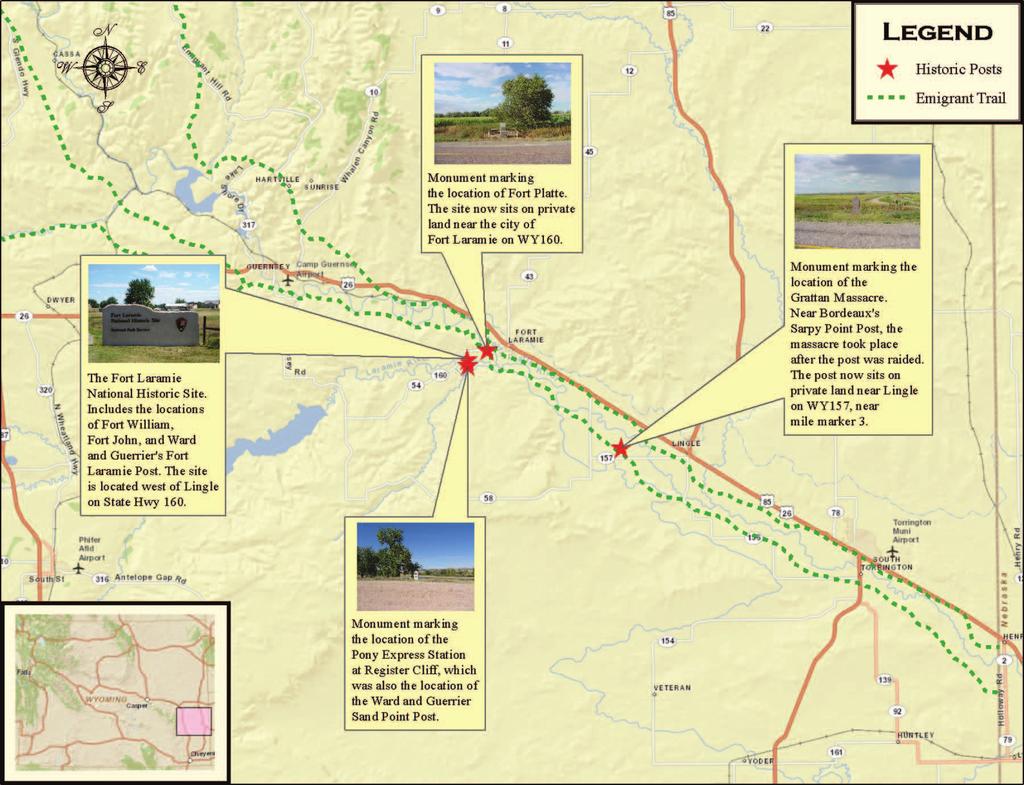
32 Post Locations Post Locations 56 57

33 Works Cited Post Locations Abel, Annie Heloise 1932 Chardon s Journal at Fork Clark University of South Dakota Department of History, Pierre. Adams, David 1841 David Adams Journals, November, David Adams Papers. Missouri Historical Society, St. Louis. Alter, J. Cecil 1962 Jim Bridger. University of Oklahoma Press, Norman. Anonymous 1943 Historic Document Tells Early Day Drama of West. Annals of Wyoming 15(3): Audubon, Maria and Elliot Cous 1897 Audubon and his Journals. C. Scribner s Sons, New York. Bagley, William 2007 South Pass: Gateway to a Continent. The Historic Context of a National Landscape. Planning and Historic Context Development Program, Wyoming State Historic Preservation Office, State Parks and Cultural Resources, Cheyenne. Barbour, Barton H A Special History Study: The Fur Trade at Fort Laramie National Historic Site. National Park Service, Santa Fe. Barnhart, Bill 1972 Register Cliff. National Register of Historic Places Inventory- Nomination Form on file, National Register of Historic Places, National Parks Service, Washington, DC. Beck, John and Brian Browning 1977 Ward and Guerrier Trading Post, Fort Laramie, Test Excavations On file, Fort Laramie National Historic Site, Fort Laramie. Beebe, Ruth Reminiscing Along the Sweetwater. Johnson Publishing Co, Boulder. Becker, Rory 2010 Finding Rendezvous: An Approach to Locating Rocky Mountain Rendezvous Sites through Use of Historic Documents, Geophysical Survey, and Lidar. Unpublished PhD dissertation. Department of Anthropology, 58 University of Wyoming. 59
Chapter 11, Section 1 Trails to the West. Pages
 Chapter 11, Section 1 Trails to the West Pages 345-349 Many Americans during the Jacksonian Era were restless, curious, and eager to be on the move. The American West drew a variety of settlers. Some looked
From the colonial days forward, Americans had continued to move westward. At first, trails were found through the Appalachians as settlers began to
 From the colonial days forward, Americans had continued to move westward. At first, trails were found through the Appalachians as settlers began to move into the fertile lands stretching toward the Mississippi
D14 BR: Were the Spaniards right? Were the Native Americans savages that needed the Spaniards help? What do you think?
 D14 BR: Were the Spaniards right? Were the Native Americans savages that needed the Spaniards help? What do you think? Utah Studies Mountain Men in Utah Goals for Today: We will learn: How the Old Spanish
Who were the Mountain Men?
 Mountain Men Who were the Mountain Men? Inspired by the adventures of Lewis and Clark, thousands of explorers and fur trappers roamed the American Rocky Mountains from about 1810 to the early 1840s. Today
The Americans (Survey)
") The Americans (Survey) Chapter 9: TELESCOPING THE TIMES Expanding Markets and Moving West CHAPTER OVERVIEW The economy of the United States grows, and so does the nation s territory, as settlers move west.
The Americans (Survey) Chapter 9: TELESCOPING THE TIMES Expanding Markets and Moving West CHAPTER OVERVIEW The economy of the United States grows, and so does the nation s territory, as settlers move west.
Utah. Copyright 2010 LessonSnips
 Utah Utah is located in the middle of the American Southwest between Nevada on the west; Arizona to the south; Colorado to the east; and Idaho and Wyoming to the north. The corners of four states (Utah,
Conflict on the Plains. Level 2
 Conflict on the Plains Level 2 Who were the tribes of the Great Plains The Major tribes were: Arapaho Blackfoot Cheyenne Comanche Crow Osage Pawnee Sioux Wichita The Comanche, Sioux, and the Cheyenne are
An Overview of U.S. Westward Expansion
 An Overview of U.S. Westward Expansion By History.com on 04.28.17 Word Count 1,231 Level MAX The first Fort Laramie as it looked before 1840. A painting from memory by Alfred Jacob Miller in 1858-60. Fort
Chapter 4 MOUNTAIN MEN
 Chapter 4 MOUNTAIN MEN Jedediah Smith Ethnicity: American Company: Ashley-Henry Company Location: All over Utah Accomplishments: Leader among trappers First to travel the length and width of Utah Proved
Westward Expansion. What did the United States look like before Westward Expansion?
 Westward Expansion What did the United States look like before Westward Expansion? In 1803, Thomas Jefferson, the third president of the United States, purchased 828,000 square miles from France. This
Johnston Farm & Indian Agency. Field Trip Guide
 Johnston Farm & Indian Agency Field Trip Guide Table of Contents Introduction to Field Trip Guide 2 Mission Statement and Schools 3 Objectives and Methods 4 Activities Outline 5 Orientation Information
The Great Encounter: American Indians Meet Explorers & Mountain Men
 Slide 1 CHAPTER 4 The Great Encounter: American Indians Meet Explorers & Mountain Men Slide 2 The Mood Just as different groups of Native American Indian people had displaced other groups who lived in
Section 1 The Oregon Country: The U.S. was a nation that was destined to be a country that reached from coast to coast.
 Chapter 14 Manifest Destiny Section 1 The Oregon Country: The U.S. was a nation that was destined to be a country that reached from coast to coast. Settlers Move West: The Oregon Country included the present
Oregon Country. Adams-Onís Treaty. Mountain Men. Kit Carson. Oregon Trail. Manifest Destiny
 Chapter 11 Section 1: Westward to the Pacific Oregon Country Adams-Onís Treaty Mountain Men Kit Carson Oregon Trail Manifest Destiny Chapter 11 Section 2: Independence for Texas Davy Crockett The area
The Vore Buffalo Jump. Research, Education, and Cultural Center
 The Vore Buffalo Jump Research, Education, and Cultural Center The Vore site is a sinkhole......a natural bowl that retained cultural materials just where the Indians left them. The volume of cultural
2. The Cowboy tradition. 3. Mining Industry. 3. Life on the Plains. 4. Facts, myths and legends
 1. Settlement of the Great Plains, 1860 to 1890 Homestead Act of 1862 Great Plains Indians Conflicts with Indians U.S. Indian Policy Treaties and Reservations Dawes Act of 1887--- Americanize Indians Indian
(2) SIGNIFICANT THEMES AND HIGHLIGHTS
 SIGNIFICANT THEMES AND HIGHLIGHTS") 13 Moving West (1) CHAPTER OUTLINE Narcissa Whitman her husb Marcus, were among thouss of Americans who played a part in the movement into the trans-mississippi West between 1830-1865. The chapter also
13 Moving West (1) CHAPTER OUTLINE Narcissa Whitman her husb Marcus, were among thouss of Americans who played a part in the movement into the trans-mississippi West between 1830-1865. The chapter also
Major Indian White Conflicts U T A H H I S T O R Y C H A P T E R 7
 Major Indian White Conflicts U T A H H I S T O R Y C H A P T E R 7 Native Americans vs. Mormons: Conflicts happened over a period of time. They were sometimes violent, but were usually resolved peacefully.
Early Settlers Fact Test 1. Name a mountain range beginning with R where you would find mountain men? 2. Which 2 US States were the early settlers
 Indians fact test 1. What n describes Indians way of life 2, Which dance involved piercing skin 3 What word means marriage to more than one wife 4. Which body part did Indians take after killing an enemy
8th - CHAPTER 10 EXAM
 Multiple Choice 8th - CHAPTER 10 EXAM Identify the choice that best completes the statement or answers the question. 1. Astoria was a significant region in the Pacific Northwest at the beginning of the
Assessment: Life in the West
 Name Date Mastering the Content Circle the letter next to the best answer.. Assessment: Life in the West 1. Which of these led to the Lewis and Clark expedition in 1804? A. Monroe Doctrine B. Gadsden Purchase
Jump Start. You have 5 minutes to study your Jackson notes for a short 7 question Quiz.
 Jump Start You have 5 minutes to study your Jackson notes for a short 7 question Quiz. All of my copies of the notes are posted on the white board for reference. Please DO NOT take them down. Manifest
Activity Introduction Hey there, I d like to welcome you to today s lesson Defining and Settling Louisiana! It s gonna expand your mind for sure!
 Defining and Settling Louisiana H1092 Activity Introduction Hey there, I d like to welcome you to today s lesson Defining and Settling Louisiana! It s gonna expand your mind for sure! Video 1 Introduction
Life in the New Nation
 Life in the New Nation United States History Fall, 2014 Cultural, Social, Religious Life How and when did the new nation s identity take shape? Cultural advancement many tried to establish national character
Examiners Report June GCSE History 5HB02 2B
 Examiners Report June 2013 GCSE History 5HB02 2B Edexcel and BTEC Qualifications Edexcel and BTEC qualifications come from Pearson, the UK s largest awarding body. We provide a wide range of qualifications
CHAPTER 7. American Indian and Pioneers (Clash of Cultures)
") CHAPTER 7 American Indian and Pioneers (Clash of Cultures) Essential Question 14 One week after the Mormons moved, the Mormons watched a bad fight, Shoshones against the Utes. Why didn t they help stop
CHAPTER 7 American Indian and Pioneers (Clash of Cultures) Essential Question 14 One week after the Mormons moved, the Mormons watched a bad fight, Shoshones against the Utes. Why didn t they help stop
Living In Territorial Utah: culture, business, transportation, and mining. Timeline. Schools in Utah Territory
 Slide 1 Living In Territorial Utah: culture, business, transportation, and mining Chapter 8 Slide 2 Timeline 1850 The University of Deseret (U of U) opens. Utah s first newspaper, the Deseret News, is
Map Exercise Routes West and Territory
 Routes to the West Unit Objective: examine the cause and effects of Independence Movements west & south of the United States; investigate and critique U.S. expansionism under the administrations of Van
UTAH...THIS IS THE PLACE
 , Gary Francis Music- Gary Francis UTAH...THIS IS THE PLACE (The State Song of Utah) Utah! People working together Utah! What a great place to be. Blessed from Heaven above. It s the land that we love.
Mormon Trail, The. William Hill. Published by Utah State University Press. For additional information about this book
 Mormon Trail, The William Hill Published by Utah State University Press Hill, William. Mormon Trail, The: Yesterday and Today. Logan: Utah State University Press, 1996. Project MUSE., https://muse.jhu.edu/.
CHAPTER 4. The Great Encounter. American Indians Meet Explorers and Mountain Men
 CHAPTER 4 The Great Encounter American Indians Meet Explorers and Mountain Men Introduction During 1765, when the American Revolution was starting to unfold, Spanish missionaries began crossing into Utah.
Appendix A. Rocky Mountain Trip List, 1804 to Dep Date From Arv Date To Party, Route and Notes
 Appendix A Rocky Mountain Trip List, 1804 to 1843 May 14 1804 St Louis Dec 7 1805 Columbia Lewis & Clark Expedition via Upper Missouri» Mar 23 1806 Oregon Sep 23 1806 St Louis and across the Rockies to
Between the early 1830s and the mid 1850s, a new political party called the Whigs ran in opposition against the Democrat party of Andrew Jackson.
 Between the early 1830s and the mid 1850s, a new political party called the Whigs ran in opposition against the Democrat party of Andrew Jackson. They believed in congressional supremacy instead of presidential
Mormon Trail, The. William Hill. Published by Utah State University Press. For additional information about this book
 Mormon Trail, The William Hill Published by Utah State University Press Hill, William. Mormon Trail, The: Yesterday and Today. Logan: Utah State University Press, 1996. Project MUSE., https://muse.jhu.edu/.
Chapter 8: Living in Territorial Utah. (Culture, Business, Transportation, and Mining)
") Chapter 8: Living in Territorial Utah (Culture, Business, Transportation, and Mining) Introduction When a new community was founded the first people slept in or under their wagons until a more permanent
Chapter 8: Living in Territorial Utah (Culture, Business, Transportation, and Mining) Introduction When a new community was founded the first people slept in or under their wagons until a more permanent
Relied on Buffalo. Nomadic. Food, clothing, and shelter. Did not believe in or even understand land ownership 200,000 lived on the Plains
 Unit 1 Section 1 Relied on Buffalo Food, clothing, and shelter Nomadic Did not believe in or even understand land ownership 200,000 lived on the Plains Stopped moving Indians west Wanted land for white
SETTLEMENTS TRANSPORTATION & MINING. Chapter 9 Utah Studies
 SETTLEMENTS TRANSPORTATION & MINING Chapter 9 Utah Studies HUNTSVILLE-1860 Seven families led by Jefferson Hunt established Huntsville in 1860. They found Shoshone living in the Ogden Valley and paid a
Treat All Men Alike: Chief Joseph and Respect
 Treat All Men Alike: Chief Joseph and Respect Compelling Question o How can lack of respect lead to tragedy and heartbreak? Virtue: Respect Definition Respect is civility flowing from personal humility.
Migration to the Americas. Early Culture Groups in North America
 Migration to the Americas Early Culture Groups in North America Motivation for European Exploration What pushed Europeans to explore? spices Middle Eastern traders brought luxury goods such as, sugar,
Name: Class Period: Date:
 Name: Class Period: Date: Unit #2 Review E George Washington H Jay s Treaty D Pinckney s Treaty G Treaty of Greenville K Whiskey Rebellion B Marbury v. Madison A. The greatest U.S. victory in the War of
American Indians in Missouri Timeline: Created by Buder Center 2019
 American Indians in Missouri Timeline: Created by Buder Center 2019 "Missouri" is a Siouan Indian word. It comes from the tribal name Missouria, which means "big canoe people." 7a We, the great mass of
Spotlight on America:
 Editor Emily R. Smith, M.A. Ed. Managing Editor Karen J. Goldfluss, M.S. Ed. Editor-in-Chief Sharon Coan, M.S. Ed. Spotlight on America: Lewis & Clark Expedition and The Louisiana Purchase Illustrator
Chapter 9 Expanding Markets and Moving West
 Chapter 9 Expanding Markets and Moving West The Market Revolution factory system changed the lives of workers and consumers. People will stop growing and making things for their own survival and begin
Dear Sir and Father, We treated them as such, and then waited to see what they would do.
 MEMORIAL TO SIR WILFRID LAURIER, PREMIER OF THE DOMINION OF CANADA FROM THE CHIEFS OF THE SHUSWAP, OKANAGAN AND COUTEAU TRIBES OF BRITISH COLUMBIA. PRESENTED AT KAMLOOPS, B.C. AUGUST 25, 1910 Dear Sir
bk09c - Manifest Destiny ( )
") bk09c - Manifest Destiny (1800-1850) MULTIPLE CHOICE 1. In the 1820s, New Mexico, Texas, and California attracted expansionists because A the U.S. government had influence over Spain. B they were rich
bk09c - Manifest Destiny (1800-1850) MULTIPLE CHOICE 1. In the 1820s, New Mexico, Texas, and California attracted expansionists because A the U.S. government had influence over Spain. B they were rich
Lewis and Clark for Kids
 Lewis and Clark for Kids Their Journey of Discovery with 21 Activities JANIS HERBERT Contents Time Line viii Preface To the Westward xi Time Line of the Lewis and Clark Expedition Map of the Expedition
Chapter 5 Lesson 1 Class Notes
 Chapter 5 Lesson 1 Class Notes The Lost Colony of Roanoke - England wanted colonies in North America because they hoped America was rich in gold or other resources. - Establish a colony is very difficult
H THE STORY OF TEXAS EDUCATOR GUIDE H. Student Objectives TEKS. Guiding Questions. Materials
 H C H A P T E R F I V E H A GROWING SENSE OF SEPARATENESS Overview Chapter 5: A Growing Sense of Separateness begins at the entrance of the Second Floor exhibits and stretches through Stephen F. Austin
Chapter 9 Trouble on the Plains
 Chapter 9 Trouble on the Plains Section 1: Reconstruction Before the War ended, Lincoln was re-elected on the National Union Party ticket with Andrew Johnson, a Tennessee Democrat. The selection of Johnson
Chapter 7 - Manifest Destiny
 Chapter 7 - Manifest Destiny 1) By the time the Civil War began, more Americans lived west of the Appalachians than lived in states along the Atlantic coast 2) Many emigrants headed for California and
The Mormon Trail: In search of the promised land
 Name Period US History 8 Mr. Tripodi The Mormon Trail: In search of the promised land Directions: 1. Read the paragraph. 2. Present the paragraph a different way. Make meaning out of what you are reading
St. Louis from the River Below by George Caitlin (1832)
") St. Louis from the River Below by George Caitlin (1832) The American Fur Company s first steamboat, the Yellow Stone, owned by Pierre Chouteau, made its first run up the Missouri leaving St. Louis on April
St. Louis from the River Below by George Caitlin (1832) The American Fur Company s first steamboat, the Yellow Stone, owned by Pierre Chouteau, made its first run up the Missouri leaving St. Louis on April
Expanding West. Chapter 11 page 342
 Expanding West Chapter 11 page 342 Trails to the West Section 1 Americans Move West In the early 1800s, Americans pushed steadily westward, moving even beyond the territory of the United States Many of
Historical Sketch of James Stewart Probably written by Elmira Mower date unknown Some minor editing by Bob Moon 2009
 Historical Sketch of James Stewart Probably written by Elmira Mower date unknown Some minor editing by Bob Moon 2009 On one of the side streets of Fairview stands an old adobe, two story house with a trap
Chapter 7. Life in the New Nation ( )
") Chapter 7 Life in the New Nation (1783 1850) America: Pathways to the Present Chapter 7: Life in the New Nation (1783 1850) Section 1: Cultural, Social, and Religious Life Section 2: Trails to the West
Chapter 7 Life in the New Nation (1783 1850) America: Pathways to the Present Chapter 7: Life in the New Nation (1783 1850) Section 1: Cultural, Social, and Religious Life Section 2: Trails to the West
The West Transformed ( )
") . The West Transformed (1860-1896) slides by Mr. Zindman A California Gold Mine in 1849. 1 NEW YORK STATE STANDARD A CHANGING SOCIETY: 8.3 EXPANSION AND IMPERIALISM: Beginning in the second half of the
. The West Transformed (1860-1896) slides by Mr. Zindman A California Gold Mine in 1849. 1 NEW YORK STATE STANDARD A CHANGING SOCIETY: 8.3 EXPANSION AND IMPERIALISM: Beginning in the second half of the
Chapter 2: Historical Overview of Independence
 Chapter 2: Historical Overview of Independence In this chapter you will find: A Brief History of the HISTORICAL OVERVIEW OF INDEPENDENCE Photograph on cover page: Independence County Courthouse remodeled
Please note: Each segment in this Webisode has its own Teaching Guide
 Please note: Each segment in this Webisode has its own Teaching Guide The conflict between Native Americans and the United States government intensified after the Battle of the Little Bighorn. Two final,
Transcontinental Railroad
 Name 1 Transcontinental Railroad Long Term Questions How have our leaders impacted the growth of the United States? (4.2.2) How did explorers and pioneers impact the growth of the United States? (4.2.1)
Expanding West. Trails to the West. The Texas Revolution. The Mexican-American War. The California Gold Rush. Section 1: Section 2: Section 3:
 Expanding West Section 1: Trails to the West Section 2: The Texas Revolution Section 3: The Mexican-American War Section 4: The California Gold Rush Section 1: Trails to the West Key Terms & People: John
Chapter 13 Westward Expansion ( ) (American Nation Textbook Pages )
 (American Nation Textbook Pages )") Chapter 13 Westward Expansion (1820-1860) (American Nation Textbook Pages 378-405) 1 1. Oregon Country In the spring of 1846 many people were on their way to the western frontier. As the nation grew many
Chapter 13 Westward Expansion (1820-1860) (American Nation Textbook Pages 378-405) 1 1. Oregon Country In the spring of 1846 many people were on their way to the western frontier. As the nation grew many
The Sauk, Fox, and the Black Hawk War of 1832
 The Sauk, Fox, and the Black Hawk War of 1832 Sauk Beginning Migration Originally located in Eastern Ontario Driven out of (eastern Ontario) Canada by rival tribes (Iroquois) who want more land to capture
Bell work. What do you think when you hear the term Manifest Destiny?
 Bell work What do you think when you hear the term Manifest Destiny? Manifest Destiny and the War with Mexico Essential Question How did the idea of Manifest Destiny affect the movement of Americans across
The College Board Advanced Placement Examination UNITED STATES HISTORY Section I1 Part A (Suggested writing time-40 Percent of Section I1 score-50
 The College Board Advanced Placement Examination UNITED STATES HISTORY Section I1 Part A (Suggested writing time-40 Percent of Section I1 score-50 minutes) Directions: The following question requires you
The First Pioneer Company Crosses the Plains.
 The First Pioneer Company Crosses the Plains. Blindfold someone and turn them around several times. Then ask the child to find the doorway to the classroom. Have the other children stand as obstacles in
WESTWARD EXPANSION II. The Expansion
 WESTWARD EXPANSION II The Expansion GOALS: WHAT I NEED TO KNOW How did the Louisiana Purchase, Texas, the Alamo, the Oregon Trail, California Gold Rush, and development of mining towns help Westward Expansion
UNITED STATES HISTORY SECTION II Part A (Suggested writing time minutes) Percent of Section II score -- 45
 Percent of Section II score -- 45") 1992 Western Expansion 1 FORM 3LBP 1992 The College Board Advanced Placement Examination UNITED STATES HISTORY SECTION II DO NOT OPEN THIS INSERT UNTIL YOU ARE TOLD TO DO SO. Do not break the seal on the
1992 Western Expansion 1 FORM 3LBP 1992 The College Board Advanced Placement Examination UNITED STATES HISTORY SECTION II DO NOT OPEN THIS INSERT UNTIL YOU ARE TOLD TO DO SO. Do not break the seal on the
PASTORAL CARE FOR NEBRASKA S NATIVE AMERICANS: CREATION OF THE MISSIONARY DISTRICT OF THE NIOBRARA
 PASTORAL CARE FOR NEBRASKA S NATIVE AMERICANS: CREATION OF THE MISSIONARY DISTRICT OF THE NIOBRARA The creation of the Missionary District of Niobrara and consecration of Rev. William Hobart Hare as its
Breaking the Stereotype: The Writings of Chief Joseph
 Grade Level: 6-8 Curriculum Focus: American History Lesson Duration: Two class periods Student Objectives Materials Understand the history of the Nez Perce tribe. Study and discuss a passage from the writings
Ch 13: Moving West Name. MULTIPLE CHOICE. Choose the one alternative that best completes the statement or answers the question.
 Ch 13: Moving West Name MULTIPLE CHOICE. Choose the one alternative that best completes the statement or answers the question. 1) By 1860, The United States had settled: A) its boundaries with both Canada
194 Elizabeth R. H oltgreive
 RECOLLECTIONS OF PIONEER DAYS To the pioneers I am known as Betty Shepard. I was born October 26th, 1840, in Jefferson County, Iowa, at a place called Brush Creek, about fifteen miles from Rome. My father,
Territorial Utah and The Utah War. Chapter 9
 Territorial Utah and The Utah War Chapter 9 Mormon and Natives Interaction When Brigham Young and the Mormons arrived in Utah the Natives welcomed them. The Natives were excited to have the Mormons in
Manifest Destiny,
 Manifest Destiny, 1810 1853 Westward expansion has political, economic, and social effects on the development of the United States. Stephen Fuller Austin, 19thcentury American frontiersman and founder
Mexican-American War Act-It-Out
 Florida Act-It-Out Follow the narration below to create an act-it-out about Florida. When the narrator says Action! the actors will move, act, and speak as described. When the narrator says Audience! the
Pocahontas. Between Two Worlds. By Mary Pat Champeau. Characters (in order of appearance)
") Pocahontas Between Two Worlds By Mary Pat Champeau Characters (in order of appearance) Narrators 1&2 Nantaquaus: Chief Powhatan s son Chief Powhatan: Leader of the Powhatan Indians Werowances 1&2: Holy
Pocahontas Between Two Worlds By Mary Pat Champeau Characters (in order of appearance) Narrators 1&2 Nantaquaus: Chief Powhatan s son Chief Powhatan: Leader of the Powhatan Indians Werowances 1&2: Holy
Chapter 5 Utah Studies
 Chapter 5 Utah Studies As the beaver trapping industry died out, many mountain men started sharing their stories of west with others. People were fascinated by the stories about California and the Oregon
*On your sticky note depict (draw) the following two words. Acquire. Expansion
 the following two words. Acquire. Expansion") *On your sticky note depict (draw) the following two words. Acquire Expansion The Northwest Ordinance of 1787 1. What did the Northwest Ordinance of 1787 establish? This act established the principles
*On your sticky note depict (draw) the following two words. Acquire Expansion The Northwest Ordinance of 1787 1. What did the Northwest Ordinance of 1787 establish? This act established the principles
Westward Expansion & America s Manifest Destiny
 Westward Expansion & America s Manifest Destiny Manifest Destiny Term first coined by newspaper editor, John O Sullivan in 1845... the right of our manifest destiny to over spread and to possess the whole
What did Lewis & Clark Do, Anyway?
 What did Lewis & Clark Do, Anyway? Thomas Jefferson sent Meriwether Lewis and William Clark on a great expedition in May, 1804. They set out on a great journey across what was then the Louisiana Territory.
Spanish Settlement in Texas
 Name!! Date Spanish Settlement in Texas! Spaniards began exploring what is now the United States in the 1500s. Cabeza de Vaca and three other members from his expedition arrived near the Galveston coast
Objective: To examine Chief Joseph, the Dawes Act, and Wounded Knee. USHC 4.1
 Objective: To examine Chief Joseph, the Dawes Act, and Wounded Knee. USHC 4.1 Do Now: How was the U.S. government attempting to destroy Native American culture? Montana North Dakota Wyoming South Dakota
Missouri. Copyright 2010 LessonSnips
 Missouri Missouri is located in the Midwest, surrounded by the states of Iowa to the north; Nebraska, Kansas and Oklahoma to the west; Arkansas to the south; and Illinois and Kentucky to the east. The
Chapter 18 The Mongols Unify Eurasia
 Chapter 18 The Mongols Unify Eurasia p243 China Under the Song Dynasty, 960-1279 Most advanced civilization in the world Extensive urbanization Iron and Steel Manufacturing Technical innovations Printing
SEVENTH GRADE ASSESSMENT
 TEACHER BACKGROUND This assessment tool was designed to objectively record the students comprehension of certain vital information regarding the American Indians of Utah. Students will need to have had
Tradition and Identity Unit Background. Native American Literature AP Literature Mrs. Boswell
 Tradition and Identity Unit Background Native American Literature AP Literature Mrs. Boswell Historical & Cultural Context Our American identity as we know it is a product of our past. Our class will focus
Supplement to Chapter 17 Conflict and Change in the West
 Supplement to Chapter 17 Conflict and Change in the West 1865-1902 The Native American Though the Native American is portrayed as being a singular stereotype, they were diverse in culture and in lifestyles
United States History. Robert Taggart
 United States History Robert Taggart Table of Contents To the Student.............................................. v Unit 1: Birth of a Nation Lesson 1: From Colonization to Independence...................
Life in the New Nation ( )
") America: Pathways to the Present Chapter 7 Life in the New Nation (1783 1850) Copyright 2005 by Pearson Education, Inc., publishing as Prentice Hall, Upper Saddle River, New Jersey. All rights reserved.
America: Pathways to the Present Chapter 7 Life in the New Nation (1783 1850) Copyright 2005 by Pearson Education, Inc., publishing as Prentice Hall, Upper Saddle River, New Jersey. All rights reserved.
Chapter 3: Removal as a Solution to the Water Crisis?
 Chapter 3: Removal as a Solution to the Water Crisis? In April 1863, Arizona Superintendent of Indian Affairs Charles Poston informed the commissioner of Indian affairs that his most important job was
Mormon Trail, The. William Hill. Published by Utah State University Press. For additional information about this book. Accessed 4 May :17 GMT
 Mormon Trail, The William Hill Published by Utah State University Press Hill, William. Mormon Trail, The: Yesterday and Today. Logan: Utah State University Press, 1996. Project MUSE., https://muse.jhu.edu/.
The Highlights of Homeschooling History Literature Unit Study. Daniel Boone. Sample file. Created by Teresa Ives Lilly Sold by
 The Highlights of Homeschooling History Literature Unit Study Daniel Boone Created by Teresa Ives Lilly Sold by www.hshighlights.com INTRODUCTION This history/literature study guide is created to use in
Manifest Destiny and Andrew Jackson
 Manifest Destiny and Andrew Jackson Study online at quizlet.com/_204f5a 1. 13 colonies 4. Andrew Jackson 2. 1849 The original states : Connecticut, Delaware, Georgia, Maryland, massachusetts, New jersey,
Who were the Mormons and why did they decide to Head West?
 Who were the Mormons and why did they decide to Head West? Learning Objectives: To understand who the Mormons were and why they were unpopular in the East. To assess how successful their move West was
JIMMY DODGING HORSE FRANCIS CROW CHIEF WILLIAM LITTLE BEAR GEORGE HEAVY FIRE OFFICE OF SPECIFIC CLAIMS & RESEARCH WINTERBURN, ALBERTA
 DOCUMENT NAME/INFORMANT: DICK STARLIGHT JIMMY DODGING HORSE FRANCIS CROW CHIEF WILLIAM LITTLE BEAR GEORGE HEAVY FIRE INFORMANT'S ADDRESS: SARCEE RESERVE ALBERTA INTERVIEW LOCATION: SARCEE RESERVE ALBERTA
JOLIET AND MARQUETTE From the Book, Historical Plays for Children By Grace E. Bird and Maud Starling Copyright 1912
 JOLIET AND MARQUETTE From the Book, Historical Plays for Children By Grace E. Bird and Maud Starling Copyright 1912 CHARACTERS: -Father Marquette -Joliet -Pierre -Jean -Jacques -Henri -Amiel -Chiefs (4)
History GCSE exam paper revision: Technique. 4 mark questions 8 mark questions 16 mark questions
 History GCSE exam paper revision: Technique. 4 mark questions 8 mark questions 12 mark questions 16 mark questions The 4 mark questions: Describe two features of. This question appears on Paper 1 about
Unit 3 Part 2. Analyze the movement toward greater democracy and its impact. Describe the personal and political qualities of Andrew Jackson.
 Unit 3 Part 2 Trace the settlement and development of the Spanish borderlands. Explain the concept of Manifest Destiny. Describe the causes and challenges of westward migration. Explain how Texas won independence
Full Congressional Testimony of Mr. John S. Smith (Use with Lesson 3) Washington, March 14, 1865
 Washington, March 14, 1865") Full Congressional Testimony of Mr. John S. Smith (Use with Lesson 3) Washington, March 14, 1865 Mr. John S. Smith sworn and examined. Question. Where is your place of residence? Answer. Fort Lyon, Colorado
Full Congressional Testimony of Mr. John S. Smith (Use with Lesson 3) Washington, March 14, 1865 Mr. John S. Smith sworn and examined. Question. Where is your place of residence? Answer. Fort Lyon, Colorado
Jim Baker, The Forgotten Man Jim Baker: Trapper, Guide, Army Scout, Businessman and Pioneer
 ASAC_Vol99_00-Carter_090004.qxp 7/23/09 4:49 PM Page 11 Jim Baker, The Forgotten Man Jim Baker: Trapper, Guide, Army Scout, Businessman and Pioneer By David Carter Often referred to as the forgotten man,
Chapter 8 From Colony to Territory to State
 Chapter 8 From Colony to Territory to State Standard 2 Key Events, Ideas and People: Students analyze how the contributions of key events, ideas, and people influenced the development of modern Louisiana.