St. Thomas, Nevada, Visual Field Guide Lake Mead NRA Visual Field Guide
|
|
|
- Gordon Ward
- 5 years ago
- Views:
Transcription

1 St. Thomas, Nevada, Visual Field Guide Lake Mead NRA St. Thomas, Visual Field Guide Nevada Explore the ruins of a real western town once underneath Lake Mead.
 8 Parking Lot/Trail Head 9 Way point A and Rail Station 10 Fenton Whitney Home 11 New Frehner Home 12 Frank Bonelli Home 13 R.E. Bunker Home 14 Moses Gibson Home 15 St.")
2 Table of Contents 1 Cover 2 Table of Contents 3 Safety 4 Directions to St. Thomas 5 History 6 Map of St. Thomas (Historic) 7 Map of St. Thomas (Today) 8 Parking Lot/Trail Head 9 Way point A and Rail Station 10 Fenton Whitney Home 11 New Frehner Home 12 Frank Bonelli Home 13 R.E. Bunker Home 14 Moses Gibson Home 15 St. Thomas Garage 16 Hannig Ice Cream Parlor 17 Nutter Store / Garage St. Thomas School House 20 Artifacts 21 Gentry Home Gentry Hotel Gentry Store 26 First Post Office 27 Way point E / Way point F 28. Syphus Home
3 EMERGENCY CALL 911 Safety There are a few simple, and prudent, rules to make your visit to St. Thomas pleasant and safe. Water The ghost city of St. Thomas is located in the Lake Mead National Recreation Area. This region of the country is part of the Mojave Desert, one of the most arid and hottest places in the United States. Average Summer temperatures at the town site in the summer can rage from 95 to 115 degrees. It is important to keep hydrated with plenty of fluids. There are no services available at the town site and the parking area is approximately 1/2 mile from the town site entrance. The best time to visit is before and after the summer heat arrives. This is generally between November and April. Pets DO NOT leave pets in parked vehicles. Temperatures can quickly rise to over 140 degrees in a closed vehicle. Pets are allowed at the town site while on a leash. Please pick up after your pets during your visit. All Dogs Must be Kept on a Leash Artifacts As you visit St. Thomas you will notice many artifacts left behind by the residents. These items such as dishes, glassware, tools, engine parts, and more are strewn about the town site. You will also notice some visitors have placed these items upon a building ruin or other grouping. For all to enjoy please do not move, or remove, any artifacts from the town site. Archaeological Protection Act of 1979 protects these artifacts for the benefit of all visitors. Any person who, without authorization, excavates, removes, damages, or otherwise defaces any historic or prehistoric site, artifact, or object of antiquity on this site is subject to arrest and penalty of law. If you see someone violating this act please contact the National Park Service at Tamarisk Vegetation The town site has been over-run with an invasive plant species called Tamarisk. These hardy plants are both a nuisance and a potential safety hazard. The branches and leaves can produce cuts and bruising, while the trunks are very hardy and when cut to a stub can puncture the soles of your shoes. Never walk barefoot through the town site and be very careful if you are wearing sandals and other types of summer wear. For more information on park rules and regulations please visit nps.gov/lake/parkmgmt/lawsandpolicies.htm
4 Directions to St. Thomas Lake Mead National Recreation Area ECHO BAY Larger Map Region Locked Access Gate Do Not Enter Restrooms Detail View CALLVILLE BAY SOUTH COVE To Overton (Interstate 15) St. Thomas Road (Dirt) Parking Trail Head BOULDER BEACH HOOVER DAM WILLOW BEACH TEMPLE BAR To Valley Of Fire Park Entrance Station Northshore Road To Lake Mead (Boulder City, Hoover Dam) COTTONWOOD COVE KATHERINE LANDING From Las Vegas (North Route) 1. Take Interstate 15 North (to Salt Lake City) 2. Exit Hwy 169, N Moapa Vally Blvd. 3. Turn Right to Overton 4. Continue through Overton 5. Park Entrance is approximately 17 miles from Interstate 15. Park entrance fee is $10 per vehicle. 6. Immediately past the entrance is a left turn onto St. Tomas Road. Follow approximately 3.25 miles. From Boulder City (South Route) 1. Take Interstate 215 East, or State Routes 93/95 South to Boulder City 2. In Boulder City Follow 93/95 to Lakeshore Rd. 3. Turn left on Lakeshore; Park entrance fee is $10 per vehicle. 4. Continue Lakeshore to Northshore (Hwy 169), turn Right 5. Approximately 50 miles right turn onto St. Tomas Road. Follow approximately 3.25 miles
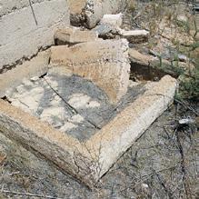
5 History Within the park boundaries lies a ghost town that was inundated when Lake Mead first filled up in the 1930 s. Once a Mormon settlement, St. Thomas thrived as a stopping point between Los Angeles and Salt Lake along the old Arrow Highway (US 91). Today, remnants of the town can now be seen thanks to the lowering water levels of Lake Mead, which is due to severe drought conditions. Once the town was flooded higher than 60 feet above the tallest structure, now visitors can roam the ghost remains of a true western town. St. Thomas lies in the northern part of the park along the Overton Arm along the Muddy River, which feeds into Lake Mead. The access road is dirt and sometimes bumpy so visitors with low riding vehicles may want to be careful. However most vehicles should be able to handle the approximately 3 mile dirt road. There is a dirt trail leading to the town site from the parking area. St. Thomas was founded in 1865 by Mormon settlers who mistakenly thought they were still in Utah(1). The location was a prime farming spot at the confluence of the Muddy and Virgin Rivers, which flowed to the Colorado River, 22 miles south. However the Mormons were not the first inhabitants of the region. The Anasazi and the Basket-Makers made their home in the area. In fact, located across the river from St. Thomas was an Anasazi settlement that become known as the Lost City, which has been recreated in the town of Overton at the Lost City Museum. One of the reasons this location was important was the abundance of salt in the region. From the Anasazi to the Mormons and beyond, salt mining was important to the life and economy of the town site. The Mormons settled here until it was discovered that they actually settled in Nevada. Nevada officials demanded three years back taxes which the Mormons refused to do. So after a vote they decided to abandon the town, save for one family, the Bonelli s. The Mormons burned down their homes and abandoned their crops and moved to Salt Lake City. Around 1880 s new settlers began to arrive at the town site. These settlers discovered that the soil was good for farming. The peak population of St. Thomas was around 500 people. There was a school, post office, grocery stores, church, ice cream parlor, and several garages for the new invention of the automobile. What St. Thomas didn t have was indoor plumbing or electricity. But memories written by the former townspeople were of fond memories and a simple life. While St. Thomas was a prime farming location, it was poorly located when it came time to ship perishable foods to market. The Los Angeles and Salt Lake Railroad extended a branch of the Oregon Short Line Through Southern Nevada in 1905, and a spur of that line went to St. Thomas. Throughout the town site you will notice square or round hollowed cement structures in the ground. These are known as cisterns and they were the water storage facilities of the day. Some are small, and some are large. In 1928, President Calvin Coolidge signed the bill authorizing the building of Hoover (Boulder) Dam. This dam would create a large lake behind it, Lake Mead, and as the waters rose areas that had been high and dry along the Muddy and Virgin Rivers would be inundated by the lake. The residents of St. Thomas were told they would have to relocate, and that the government would reimburse them for their property. The completion of the dam in As the waters rose, slowly the town was overtaken by Lake Mead. According to folklore, the last resident to leave was Hugh Lord, who paddled away from his home when the rising waters reached his home in When the lake reached it s high water mark, St. Thomas was sixty feet below the surface. With the fluctuations of the lake water levels, St. Thomas has arisen from the depths several times since In 1945, 1963, and 2012 there were reunions of former residents and family members. Today the town is still exposed and visitors can roam the roads and trails that were once a thriving wild west town.
6 W N S St. Thomas Pre-Flooding Based on the recollection of Merle Frehner, resident (Not to Scale) Irrigation Canal E St. Thomas Today Region To Bonnelli Ferry and Salt Mine (NV) = Not Visible on Map RR Cattle Corral Engine House Ore Unloading Platform Packing Shed Water Tank Windmill First Frehner Home Roxton Whitmore S.E. Whitney New Frehner Home Fenton Whitney Frank Bonelli R.E. Bunker Ed Syphus Moses Gibson St. Thomas Garage Louis Adams George Pearson Sellar s Cafe & Pool Hall Haninnig Ice Cream Parlor Nutter Store Garage Preston Hay, Nutter Storage Baver Home & Blacksmith Lost City Pagent Stage (NV) Everett Syphus (NV) Will Liston (NV) R.O. Gibson St. Thomas School House M.A. Bunker Samuel Gentry First School/Relief Society Hall J.F. Perkins Gentry Hotel Gentry Store First Post Office Luke Whitney Vern Howell Albert Stresser Frank Getzel Alfred Syphus Harry Frehner Charles Foxley H. Gentry Jr St Thomas Post Office Jim Foxley Robert Chadburn Joe Pearson Jim Sellars Lyman Armfield Small Streets & Trails Muddy River Cemetary


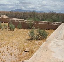
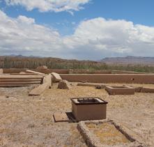
7 8 St. Thomas Today A B N C W S E F D E Legend A Visual 10 Accessable Way Points Structures Original Roads Town Trail Parking Trail


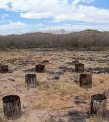
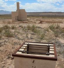
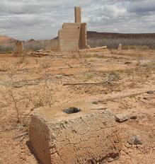
8 Parking Lot/Trail Head Looking Southeast Trail 8 Whitmore Home Looking Southeast


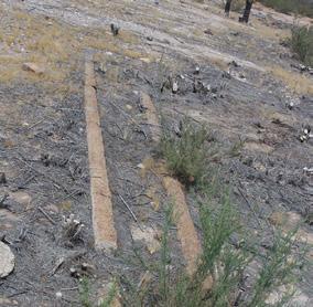
9 Way Point A Looking Southeast 2 Rail Lines 4 Packing Shed 5 Water Tower

10 11 Fenton Whitney Home Looking North


11 10 New Frehner Home Looking West

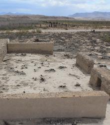
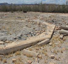
12 12 Frank Bonelli Home Looking East

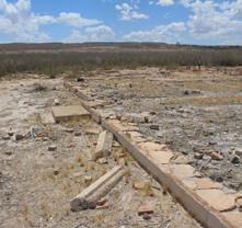
13 13 R.E. Bunker Home Looking South


14 15 Moses Gibson Home Looking East Fallen Tree Above in 1945


15 16 St. Thomas Garage Looking West Artist rendering of St. Thomas circa 1910 Artist Rendering of St. Thomas Today


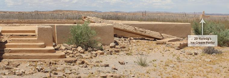
16 20 Hannig Ice Cream Parlor Looking North


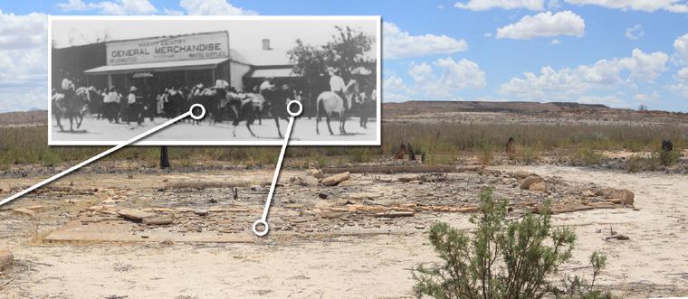
17 22 Nutter Store Looking East 21 Garage Way Point B


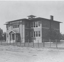
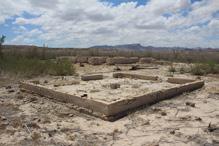
18 29 St. Thomas School House Looking West
19


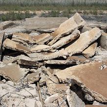
20 Artifacts Around St. Thomas Note: Artifacts are protected by Federal Law and may not be removed without permission.


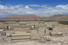
21 31 Gentry Home Looking East Way Point C


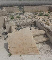
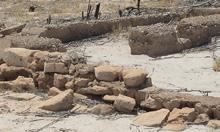
22 34 Gentry Hotel Looking South

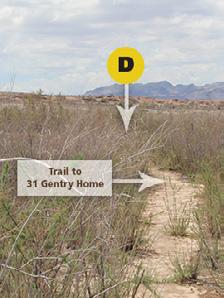
23 Way Point D


24 35 Gentry Store Looking South
25


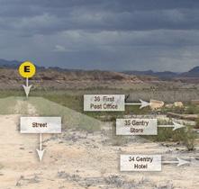
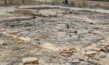
26 36 First Post Office Looking West

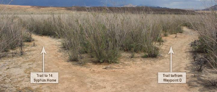
27 Way Point E Way Point F


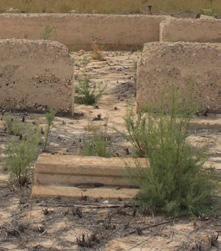
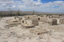
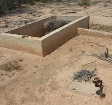
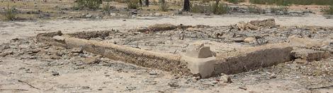
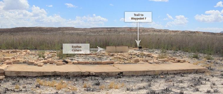
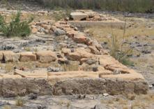
28 14 Syphus Home Looking South Front Entrance in photo at left

29
Name Period Parent Signature (EC) LESSON PACKET NEVADA 7 th Social Studies DUE DATE:
 LESSON PACKET NEVADA 7 th Social Studies DUE DATE:") Name Period Parent Signature (EC) LESSON PACKET NEVADA 7 th Social Studies DUE DATE: Much of ancient Nevada use to be covered by waters from ancient Lake Lahontan. Indians from Nevada included the Washoe,
Name Period Parent Signature (EC) LESSON PACKET NEVADA 7 th Social Studies DUE DATE: Much of ancient Nevada use to be covered by waters from ancient Lake Lahontan. Indians from Nevada included the Washoe,
Hell Or High Water. Eilean Adams. Published by Utah State University Press. For additional information about this book
 Hell Or High Water Eilean Adams Published by Utah State University Press Adams, Eilean. Hell Or High Water: James White's Disputed Passage through Grand Canyon, 1867. Logan: Utah State University Press,
Guide to the UNLV Photograph Collection on Southern Nevada
 Guide to the UNLV Photograph Collection on Southern Nevada This finding aid was created by Maryse Lundering-Timpano and Lindsay Oden on April 27, 2018. Persistent URL for this finding aid: http://n2t.net/ark:/62930/f1kp7x
The. Lytle R anch Preserve
 The Lytle R anch Preserve Mission Statement The Lytle Ranch Preserve is a remarkable desert laboratory located at the convergence of the Great Basin, Colorado Plateau, and Mojave Desert biogeographical
It was near this spot that J. D. Lee operated his ferry across the Colorado. Photo Paul Fretheim
 It was near this spot that J. D. Lee operated his ferry across the Colorado. Photo Paul Fretheim CLICK IN IMAGE TO OPEN A 360 PANO OF THIS LOCATION. Topo Map: Glen Canyon Dam; Coordinates: 36 52 N - 111
Final Study Guide. Name:
 1. What were the Rocky Mountains formed by? 2. What was the Great Basin formed by? 3. What region of Utah has Utah s national parks in it? 4. What created the smaller mountain ranges in Utah, like the
Journey through Time: Arizona, From Territory to Statehood
 Journey through Time: Arizona, From Territory to Statehood What s Your Role? You will be given the name of a person or group who were important to Arizona s early history. Through their eyes, you will
NOVEMBER 2017 LESSON, ARTIFACT, AND MUSIC. November 2017 DUP Lesson Cove Fort Ellen Taylor Jeppson
 NOVEMBER 2017 LESSON, ARTIFACT, AND MUSIC November 2017 DUP Lesson Cove Fort Ellen Taylor Jeppson The great Mormon pioneer migration to the West began in 1847 when the pioneers made their way to the Salt
Bulk Lot Sale - Kanab, UT Kanab, UT 84741
 NAI Utah South is pleased to offer the following exclusive listing: FOR SALE Kanab, UT 84741 Click For More Info Mesa Hills new home subdivision is located in Kanab, Utah. It is a 47 lot subdivision developed
Deer Range Ranch Skutumpah Rd MM 500 Cannonville, UT
 NAI Utah South is pleased to offer the following exclusive listing: FOR SALE Skutumpah Rd MM 500 Cannonville, UT Click For More Info Click For More Info 640+/- Acre South Central Utah Cattle Ranch Sweeping
Western Trails & Settlers
 Western Trails & Settlers Today, you will be able to: Identify selected racial, ethnic, and religious groups that settled in the US and reasons for immigration Westward Trails & Settlers Directions: 1.
SALE OFFERING SANDY OFFICE CONDO BUILDING. FOR SALE > OFFICE CONDO Sandy Office Condo 9065 SOUTH 1300 EAST SANDY, UT. Sale Price: $1,735,000
 SALE OFFERING SANDY OFFICE CONDO BUILDING Colliers International is pleased to present this office condominium building for sale. This impressive, 2 story, 9,597 square foot Class A condo building is ideally
Walter J. Lubken Collection, 1908 Finding Aid Sharlot Hall Museum PB 168, F. 9
 Walter J. Lubken Collection, 1908 Finding Aid Sharlot Hall Museum PB 168, F. 9 Acquisition The Walter J. Lubken Collection was donated by Mr. and Mrs. Thomas J. Kollenborn Oct 7, 2002 (acc#2002.122). Processing
Chapter 4 MOUNTAIN MEN
 Chapter 4 MOUNTAIN MEN Jedediah Smith Ethnicity: American Company: Ashley-Henry Company Location: All over Utah Accomplishments: Leader among trappers First to travel the length and width of Utah Proved
Utah. Copyright 2010 LessonSnips
 Utah Utah is located in the middle of the American Southwest between Nevada on the west; Arizona to the south; Colorado to the east; and Idaho and Wyoming to the north. The corners of four states (Utah,
SETTLEMENTS TRANSPORTATION & MINING. Chapter 9 Utah Studies
 SETTLEMENTS TRANSPORTATION & MINING Chapter 9 Utah Studies HUNTSVILLE-1860 Seven families led by Jefferson Hunt established Huntsville in 1860. They found Shoshone living in the Ogden Valley and paid a
Utah Settlement and Mining
 Utah Settlement and Mining Pioneers Enter the Valley July 24, 1847 2 Mormon Holiday Pioneer Day July 24 This is when Brigham Young entered the valley. !! Famous words: THIS IS THE PLACE This is the right
netw rks Where in the world? When did it happen? Mesopotamia Lesson 1 The Sumerians ESSENTIAL QUESTION Terms to Know GUIDING QUESTIONS
 NAME DATE CLASS Lesson 1 The Sumerians Terms to Know ESSENTIAL QUESTION silt small particles of fertile soil irrigation a way to supply dry land with water through ditches, pipes, or streams surplus an
Between the early 1830s and the mid 1850s, a new political party called the Whigs ran in opposition against the Democrat party of Andrew Jackson.
 Between the early 1830s and the mid 1850s, a new political party called the Whigs ran in opposition against the Democrat party of Andrew Jackson. They believed in congressional supremacy instead of presidential
x On record with the USOE.
 Textbook Alignment to the Utah Core 4 th Grade Social Studies This alignment has been completed using an Independent Alignment Vendor from the USOE approved list (www.schools.utah.gov/curr/imc/indvendor.html.)
Rallies. Presidents Message
 March 2015 Editor Kathie Richmond Tech Support Frank Richmond Frichmond1@Yahoo.com Presidents Message Hello again fellow good guys. Boy the time sure flies when we are having a good time, and lately we
10. Where (in what regions) were the first major mining discoveries made in Utah?
 were the first major mining discoveries made in Utah?") Name Test Date Hour Chapter 9 & 10 Study Guide Settlement, Transportation, and Mining; The Territory Prospers Notes A Place of Many Religions (pg. 168-169) Describe what each religion contributed to Utah.
Name Test Date Hour Chapter 9 & 10 Study Guide Settlement, Transportation, and Mining; The Territory Prospers Notes A Place of Many Religions (pg. 168-169) Describe what each religion contributed to Utah.
"Itty Bitty Mormon City"
 "Itty Bitty Mormon City" It s time to think small; really small. Your goal is to find the items pictured on the attached two pages. These items represent nearly unrecognizable bits and pieces of buildings,
Chapter 5 Utah Studies
 Chapter 5 Utah Studies As the beaver trapping industry died out, many mountain men started sharing their stories of west with others. People were fascinated by the stories about California and the Oregon
Territorial Utah and The Utah War. Chapter 9
 Territorial Utah and The Utah War Chapter 9 Mormon and Natives Interaction When Brigham Young and the Mormons arrived in Utah the Natives welcomed them. The Natives were excited to have the Mormons in
Chapter 9 Expanding Markets and Moving West
 Chapter 9 Expanding Markets and Moving West The Market Revolution factory system changed the lives of workers and consumers. People will stop growing and making things for their own survival and begin
The Americans (Survey)
") The Americans (Survey) Chapter 9: TELESCOPING THE TIMES Expanding Markets and Moving West CHAPTER OVERVIEW The economy of the United States grows, and so does the nation s territory, as settlers move west.
The Americans (Survey) Chapter 9: TELESCOPING THE TIMES Expanding Markets and Moving West CHAPTER OVERVIEW The economy of the United States grows, and so does the nation s territory, as settlers move west.
Where in the world? Mesopotamia Lesson 1 The Sumerians ESSENTIAL QUESTION. Terms to Know GUIDING QUESTIONS
 Lesson 1 The Sumerians ESSENTIAL QUESTION How does geography influence the way people live? GUIDING QUESTIONS 1. Why did people settle in? 2. What was life like in Sumer? 3. What ideas and inventions did
How did the Transcontinental Railroad Change Utah s Economy?
 How did the Transcontinental Railroad Change Utah s Economy? GRADE 4 How did the Transcontinental Railroad Change Utah s Economy? By Rebecca Kirkman Summary Students will read about how the railroad changed
THE GREAT DEPRESSION AND THE NEW DEAL. Utah History
 THE GREAT DEPRESSION AND THE NEW DEAL Utah History A World Wide Depression 1929-1941- Economic hard times Overproduction of goods, bank failures, and a stock market crash caused the Great Depression Why
Central Pennsylvania Basket Weavers Guild
 Central Pennsylvania Basket Weavers Guild JUNE 2014 Newsletter # 66 2014 GUILD BOARD MEMBERS PRESIDENT: Donna Kumpf... 717-938-8223 kumpf4@comcast.net VICE PRESIDENT / SECRETARY: Jeff Shields...717-774-3508
Mormon Trail, The. William Hill. Published by Utah State University Press. For additional information about this book
 Mormon Trail, The William Hill Published by Utah State University Press Hill, William. Mormon Trail, The: Yesterday and Today. Logan: Utah State University Press, 1996. Project MUSE., https://muse.jhu.edu/.
Reclaimed from a Contracting Zion: The Evolving Significance of St. Thomas, Nevada
 UNLV Theses, Dissertations, Professional Papers, and Capstones 5-1-2012 Reclaimed from a Contracting Zion: The Evolving Significance of St. Thomas, Nevada Aaron James Mcarthur University of Nevada, Las
Era 1 and Era 2 Test. 1. Which geographic feature was most important to the development of the early river valley civilizations?
 1. Which geographic feature was most important to the development of the early river valley civilizations? A. fertile soils B. high mountains C. vast deserts D. smooth coastlines 2. The study of culture
History 32S IB Local History Tour Assignment
 History 32S IB Local History Tour Assignment Before the Trip 1. Review the ArcGIS map of our tour to get a preview of where we are going. The green flags indicate places where we will stop or drive by.
1
 1 Experience the many layers of Payson Welcome to Payson, Utah we invite you to experience the many layers our city has to offer. You ll enjoy our city s rich history, opportunities for business growth,
Chapter 8: Living in Territorial Utah. (Culture, Business, Transportation, and Mining)
") Chapter 8: Living in Territorial Utah (Culture, Business, Transportation, and Mining) Introduction When a new community was founded the first people slept in or under their wagons until a more permanent
Chapter 8: Living in Territorial Utah (Culture, Business, Transportation, and Mining) Introduction When a new community was founded the first people slept in or under their wagons until a more permanent
The Mormon Trail: In search of the promised land
 Name Period US History 8 Mr. Tripodi The Mormon Trail: In search of the promised land Directions: 1. Read the paragraph. 2. Present the paragraph a different way. Make meaning out of what you are reading
History of JAMES WILLIAM BOOTH (This text of this history was written in part by Marie
 History of JAMES WILLIAM BOOTH (This text of this history was written in part by Marie Booth, Wife of Fred Booth) James William Booth was born in St. George, Utah to James and Elizabeth Tye Booth. His
Non-fiction: A Well-Kept Secret
 Non-fiction: A Well-Kept Secret A Well-Kept Secret Leigh Haeger In the 1940s, a young cowboy named Waldo Wilcox stumbled upon an ancient treasure in a remote area in Utah called Range Creek Canyon. He
Johnston Farm & Indian Agency. Field Trip Guide
 Johnston Farm & Indian Agency Field Trip Guide Table of Contents Introduction to Field Trip Guide 2 Mission Statement and Schools 3 Objectives and Methods 4 Activities Outline 5 Orientation Information
Welcome to our Supporter team!
 Welcome to our Supporter team! We are delighted that you are joining our Supporter Team for our biggest event of the year! Thank you so much for supporting your #TeamSamaritans runner in the 2018 London
Comal Settlement CONTEXT
 Comal Settlement CONTEXT Comal, Texas (now an annexed portion of Schertz, Texas) sits amidst land through which traverses the El Camino Real de los Tejas Historic National Trail System (AKA: Kings Highway
CHAPTER 7. American Indian and Pioneers (Clash of Cultures)
") CHAPTER 7 American Indian and Pioneers (Clash of Cultures) Essential Question 14 One week after the Mormons moved, the Mormons watched a bad fight, Shoshones against the Utes. Why didn t they help stop
CHAPTER 7 American Indian and Pioneers (Clash of Cultures) Essential Question 14 One week after the Mormons moved, the Mormons watched a bad fight, Shoshones against the Utes. Why didn t they help stop
CABLE/ VOLTAIRE, VOLTAIRE AND 4920 VOLTAIRE SAN DIEGO, CA OFFERING MEMORANDUM
 2216-2218 CABLE/4904-4906 VOLTAIRE, 4912-4918 VOLTAIRE AND 4920 VOLTAIRE SAN DIEGO, CA 92107 OFFERING MEMORANDUM PRESENTED BY Judy Preston CA BRE Lic. 01074104 619.309.9559 Judy@TeamPreston.net Jim Greer
The DONNER Party. A test of survival...
 The DONNER Party A test of survival... Be sure to have a Learning Journal out! You will be asked to complete a series of tasks as this slide show progresses. Be ready when you see this: Learning Objectives:
Mormon Trail, The. William Hill. Published by Utah State University Press. For additional information about this book
 Mormon Trail, The William Hill Published by Utah State University Press Hill, William. Mormon Trail, The: Yesterday and Today. Logan: Utah State University Press, 1996. Project MUSE., https://muse.jhu.edu/.
Fanny Cropper Powell Camp Heritage Hall 4365 South 4000 West, Deseret, Utah 84624
 Fanny Cropper Powell Camp Heritage Hall 4365 South 4000 West, Deseret, Utah 84624 Stove The stove is out of John and Musetta Western home that was next door to our Heritage Hall. They were married in 1892,
Guide to the Sidney R. Whitmore Collection on Southern Nevada
 Guide to the Sidney R. Whitmore Collection on Southern Nevada This finding aid was created by John Grygo on September 25, 2017. Persistent URL for this finding aid: http://n2t.net/ark:/62930/f13k5s 2017
H THE STORY OF TEXAS EDUCATOR GUIDE H. Student Objectives TEKS. Guiding Questions. Materials
 H C H A P T E R F I V E H A GROWING SENSE OF SEPARATENESS Overview Chapter 5: A Growing Sense of Separateness begins at the entrance of the Second Floor exhibits and stretches through Stephen F. Austin
Major Indian White Conflicts U T A H H I S T O R Y C H A P T E R 7
 Major Indian White Conflicts U T A H H I S T O R Y C H A P T E R 7 Native Americans vs. Mormons: Conflicts happened over a period of time. They were sometimes violent, but were usually resolved peacefully.
APRIL 2018 LESSON, ARTIFACT, AND MUSIC. APRIL 2018 DUP Lesson HISTORIC CHESTERFIELD, IDAHO. Maryann Ruben Jensen
 APRIL 2018 LESSON, ARTIFACT, AND MUSIC APRIL 2018 DUP Lesson HISTORIC CHESTERFIELD, IDAHO Maryann Ruben Jensen The term ghost town evokes images of ramshackle buildings scattered in a sagebrush-strewn
The First Pioneer Company Crosses the Plains.
 The First Pioneer Company Crosses the Plains. Blindfold someone and turn them around several times. Then ask the child to find the doorway to the classroom. Have the other children stand as obstacles in
Town Council Public Hearing & Regular Meeting Minutes Page 1
 Minutes of the regular meeting & public hearing of the Town Council of the Town of Apple Valley, Washington County, Utah that was held on the 18 th day of May, 2017 at the Town Office Building, 1777 N.
30 m o u n t a i n d i s c o v e r i e s
 30 m o u n t a i n d i s c o v e r i e s Editor s Note: All photographs accompanying The Amish of Gortner, Maryland and An Amish Barn Raising depict the landscape and residents of the community during
Interviewer-Jeff Elstad Tell me about your arrangement with The Nature Conservancy, and how has it been working?
 Rancher Heidi, tell me the history of the Dugout Ranch. Well, s the ranch originally started in the 1800's and it's been a cattle ranch for over a hundred years now. Al Scorup was the main organizer of
Guide to the Elbert Edwards Papers
 This finding aid was created by Marie Imus, Ian M. Baldwin, and Melise Leech on November 22, 2017. Persistent URL for this finding aid: http://n2t.net/ark:/62930/f1qk5c 2017 The Regents of the University
Episode 31 Legacy EARLY SALT LAKE CITY
 Episode 31 Legacy EARLY SALT LAKE CITY [BEGIN MUSIC] NATHAN WRIGHT: One of the most remarkable aspects of the Church of Jesus Christ of Latter Day Saints is its unique history. Throughout the world great
Route miles; 9 hours, 15 minutes
 Route-8 434.9 les; 9 hours, 15 nutes 0 20 40 60 Page 1 1 2 3 7:00 AM 0.0 Depart Sheraton Colorado Springs Hotel [2886 S Circle Dr, Colorado Springs, CO 80906, (719) 576-5900] on SR-29 [S Circle Dr] (West)
Poverty and Hope Appeal 2017 Sunday School Resources
 Poverty and Hope Appeal 2017 Sunday School Resources (an updated version of the 2016 pack) Preparation Flipchart paper and pens The Parable of the Five Talents: Matthew 25: 14-30 Map of the World (below)
Access Statement for Coventry Cathedral
 Access Statement for Coventry Cathedral Introduction Coventry Cathedral is situated in the city centre of Coventry. The site includes the second Cathedral (known as the old Cathedral and often referred
Guide to the Syphus-Bunker Papers
 This finding aid was created by John A. Heldt and Angela Moor on March 26, 2018. Persistent URL for this finding aid: https://n2t.net/ark:/62930/f1q03r 2018 The Regents of the University of Nevada. All
Finding Aid to the Ernest Kempe Collection Albin O. Kuhn Library and Gallery, University of Maryland, Baltimore County
 The University of Maryland, Baltimore County The Albin O. Kuhn Library & Gallery 1000 Hilltop Circle Baltimore, Maryland 21250 speccoll@umbc.edu Ernest Kempe Collection Size of Collection: 850 items; 2.5
P.O. Box Las Vegas, NV
 February 24, 2014 State of Nevada Department of Wildlife Mr. Bruce McDaniel 1100 Valley Road Reno, Nevada 89512 Dear Mr. McDaniel: Subject: WILDLIFE HERITAGE TRUST ACCOUNT PROPOSALS Muddy, Virgin, Goldbutte,
First Presbyterian Church Hannibal, Missouri
 First Presbyterian Church Hannibal, Missouri FPC Hannibal, Page 1 Our Mission Statement: We are a church that is committed to fulfilling the Great Commission and obeying the Great Commandment. Our Purpose:
THE WEST QUARTER 251 WEST 100 SOUTH, SALT LAKE CITY, UT. Tanner Olson Joe Mills
 THE WEST QUARTER 251 WEST 100 SOUTH, SALT LAKE CITY, UT Joe Mills jmills@legendllp.com 801.930.6755 Tanner Olson tolson@legendllp.com 801.930.6752 Heather Bogden hbogden@legendllp.com 801.930.6793 North
8th - CHAPTER 10 EXAM
 Multiple Choice 8th - CHAPTER 10 EXAM Identify the choice that best completes the statement or answers the question. 1. Astoria was a significant region in the Pacific Northwest at the beginning of the
Summary of Newspaper Articles
 Summary of Newspaper Articles Deseret News Salt Lake City, UT (last date searched 07/27/1959) Headline: Quake Hits Kanab Area Date: 07/22/1959 Info Categories: E, P Salt Lake Tribune Salt Lake City, UT
Startling Story of the First Trip From Salt Lake to Los Angeles
 139 Startling Story of the First Trip From Salt Lake to Los Angeles Article from the Deseret Evening News, Saturday, 7 October 1905 Who first crossed the trail to Los Angeles from Salt Lake? The question
Gila Valley Irrigation Ditrht Safford, Arizona
 Gila Valley Irrigation Ditrht Safford, Arizona Gila Valley Irrigation Ditrkft Safford, Arizona Aerial Photo, Gila Valley Near Saford / (3 May 3, 1928. Mr. P. G. Spilsbury, President, Arizona Industrial
Transcontinental Railroad
 Name 1 Transcontinental Railroad Long Term Questions How have our leaders impacted the growth of the United States? (4.2.2) How did explorers and pioneers impact the growth of the United States? (4.2.1)
Andrew Jackson becomes President
 Andrew Jackson becomes President Andrew Jackson Presidency Timeline Directions: 1.Read each slide 2.Summarize by answering the questions 3.Write vocabulary words on page 54 Expanded Voting rights to the
ESSENTIAL QUESTION: What changes in the late 1800 s caused the Utah Territory to continue to prosper?
 Name /150 CHAPTER 10 COVERSHEET ESSENTIAL QUESTION: What changes in the late 1800 s caused the Utah Territory to continue to prosper? /25 Chapter 10 Study Guide /25 Timeline and Vocab Assignment /25 Wedding
NEVADA STATE BOARD ON GEOGRAPHIC NAMES
 NEVADA STATE BOARD ON GEOGRAPHIC NAMES MINUTES May 11, 2010 The meeting began at 10:30 AM at the Great Basin Science Sample and Records Library, 2175 Raggio Parkway, Reno. Board members and guests introduced
Mexican-American War Act-It-Out
 Florida Act-It-Out Follow the narration below to create an act-it-out about Florida. When the narrator says Action! the actors will move, act, and speak as described. When the narrator says Audience! the
Living In Territorial Utah: culture, business, transportation, and mining. Timeline. Schools in Utah Territory
 Slide 1 Living In Territorial Utah: culture, business, transportation, and mining Chapter 8 Slide 2 Timeline 1850 The University of Deseret (U of U) opens. Utah s first newspaper, the Deseret News, is
The Guide to the Robert Woodruff Papers
 This finding aid was created by Crystal Aubuchon-Mendoza and Kayla McDuffie on September 25, 2017. Persistent URL for this finding aid: http://n2t.net/ark:/62930/f1760b 2017 The Regents of the University
NOTES AND DOCUMENTS. SPENCER ARMSTRONG TO ABRAHAM SHANKLIN, August 15,16,1864 [A.L.S.] COBB RIVER P.O. WASECA COUNTY MINN.^
![NOTES AND DOCUMENTS. SPENCER ARMSTRONG TO ABRAHAM SHANKLIN, August 15,16,1864 [A.L.S.] COBB RIVER P.O. WASECA COUNTY MINN.^](/thumbs/94/120337734.jpg "NOTES AND DOCUMENTS. SPENCER ARMSTRONG TO ABRAHAM SHANKLIN, August 15,16,1864 [A.L.S.] COBB RIVER P.O. WASECA COUNTY MINN.^") NOTES AND DOCUMENTS PROMOTING SETTLEMENT IN THE SIXTIES The following letter was written In 1864 by Spencer Armstrong, who emigrated from Indiana and settled In northern Faribault County, Minnesota, to
NOTES AND DOCUMENTS PROMOTING SETTLEMENT IN THE SIXTIES The following letter was written In 1864 by Spencer Armstrong, who emigrated from Indiana and settled In northern Faribault County, Minnesota, to
Juab County Information for Students
 Juab County Information for Students LOCATION Juab County sometimes called the "Key" County, is located in West-Central Utah and extends westward from the mountains of the Uinta National Forest, near the
Warm- Up 3/21 List three mo4ves, or reasons, for why the Lewis and Clark expedi4on explored the West.
 Warm- Up 3/21 List three mo4ves, or reasons, for why the Lewis and Clark expedi4on explored the West. Who Were the Explorers? In the early 1800s, a number of expedi4ons set out from the United States to
MINUTES OF THE PLANNING COMMISSION MEETING OF GARDEN CITY, UTAH
 MINUTES OF THE PLANNING COMMISSION MEETING OF GARDEN CITY, UTAH The Garden City Planning Commission held their regularly scheduled meeting on Wednesday, January 8, 2014 at the Garden City Lakeview Building
Chapter 11, Section 1 Trails to the West. Pages
 Chapter 11, Section 1 Trails to the West Pages 345-349 Many Americans during the Jacksonian Era were restless, curious, and eager to be on the move. The American West drew a variety of settlers. Some looked
After an introduction like that and the
 We Believe in Prophecy LEGRAND RICHARDS After an introduction like that and the beautiful song we just heard, I ought to be able to say something even if I am nearly a hundred years old. I greet you all
American Westward Expansion
 Chapter 9 Americans Head West In 1800 less than 400,000 settlers lived west of the Appalachian Mountains. By the beginning of the Civil War, more Americans lived west of the Appalachians than lived along
Today, you will be able to: Identify Explain
 Westward Expansion Today, you will be able to: Identify the major events of the Westward Expansion Era; Explain Manifest Destiny and westward growth of the nation Directions: 1. Write vocabulary words
Chapters 10 & 11 Utah Studies
 Chapters 10 & 11 Utah Studies Chapter 10-The Territory Prospers The Railroad Changes Utah Trains were important for moving raw materials from mines to manufacturing centers. They also carried raw material
IDAHO'S UPPER SNAKE RIVER BASIN
 IDAHO'S UPPER SNAKE RIVER BASIN Eagle Rock s (Idaho Falls) Wooden Taylor Toll Bridge in Background and first Railroad Bridge. 1808, It is believed that the first white man to enter the Upper Snake River
Cultures Clash on the Prairie. Section 1
 Section 1 Cultures Clash on the Prairie Section 1 Some Native Americans of the Plains lived in communities, farming and hunting All were religious and believed the land was for all, not one owner Most
MINUTES OF THE MEETING OF THE TOWN COUNCIL OF GARDEN CITY, UTAH
 MINUTES OF THE MEETING OF THE TOWN COUNCIL OF GARDEN CITY, UTAH The Garden City Town Council held their regularly scheduled meeting held on July 11, 2013 at the Garden City Office, located at 69 N. Paradise
Day 1: Australia Los Angeles Welcome to Los Angeles
 National Parks and Natural Wonders Explorer Tour with Alaska Deluxe Cruise 19 Days Day 1: Australia Los Angeles Welcome to Los Angeles Your journey of discovery begins here. On arrival at the airport,
Name: Date: Period: #: Chapter 9: Outline Notes Ancient India
 Name: Date: Period: #: Lesson 9.1 Early Civilizations Chapter 9: Outline Notes Ancient India The Geography of India: India and several other countries make up the of India. o A subcontinent is a large
National Association of Women Judges 2015 Annual Conference Salt Lake City, Utah. Salt Lake City Temple Square Tours
 National Association of Women Judges 2015 Annual Conference Salt Lake City, Utah Salt Lake City Temple Square Tours One step through the gates of Temple Square and you ll be immersed in 35 acres of enchantment
Lindon City Community Profile Section
 Lindon City Community Profile Section This section of the City s 2010-2011 presents information regarding the City s rich culture, location, population, education, economic development, and statistics.
A Cartographic Journey through Las Vegas History: Tracing the Las Vegas Landscape through Maps
 Library Faculty Publications Library Faculty/Staff Scholarship & Research 3-2008 A Cartographic Journey through Las Vegas History: Tracing the Las Vegas Landscape through Maps Su Kim Chung University of
(29) Brooke Smith Was a Builder
 Brooke Smith Was a Builder") Continuation of; THE PROMISED LAND A HISTORY OF BROWN COUNTY, TEXAS by James C. White (29) Brooke Smith Was a Builder BROOKE SMITH came to Brownwood February 8, 1876, at the age of 23. He died here in
Continuation of; THE PROMISED LAND A HISTORY OF BROWN COUNTY, TEXAS by James C. White (29) Brooke Smith Was a Builder BROOKE SMITH came to Brownwood February 8, 1876, at the age of 23. He died here in
Student Name: Teacher: Period: Date: Directions: Read the following selection and answer the questions that follow.
 Student Name: Teacher: Period: Date: 1 of 8 Directions: Read the following selection and answer the questions that follow. Paragraph 1 The Gulls of Salt Lake At last, they were safe. A brave little company
Oregon Country. Adams-Onís Treaty. Mountain Men. Kit Carson. Oregon Trail. Manifest Destiny
 Chapter 11 Section 1: Westward to the Pacific Oregon Country Adams-Onís Treaty Mountain Men Kit Carson Oregon Trail Manifest Destiny Chapter 11 Section 2: Independence for Texas Davy Crockett The area
Mesopotamian Civilization For use with pages 16 23
 Name Date Class READING ESSENTIALS AND STUDY GUIDE 1-2 Mesopotamian Civilization For use with pages 16 23 Key Terms civilization: complex societies (page 17) irrigation: man-made way of watering crops
In Loving Memory of Major Stephen Del Bagno
 OFFICE DETAILS Commissioner Marilyn Kirkpatrick Northeast Newsletter May 2018 Located on the 6th floor at the Government Center Phone: 702-455-3504 Address: 500 S. Grand Central Pkwy. Box 551601 Las Vegas,
Stevensons On Cape Horn 126 Years
 THE VANCOUVER COLUMBIAN FRIDAY MARCH 14, 1980 Stevensons On Cape Horn 126 Years By BOB BECK Columbian Staff Writer When John W. Stevenson looks out the window of his home, he sees history in every direction.