2/9/2017 FEBRUARY 23, Joseph D. Fenicle, PS Ohio & Michigan Professional Surveyor Angular By Nature, LLC Adrian, Michigan
|
|
|
- Maximilian Parsons
- 5 years ago
- Views:
Transcription

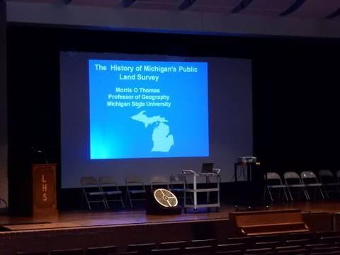
1 FEBRUARY 23, 2017 Radisson Plaza Hotel Kalamazoo, MI Joseph D. Fenicle, PS Ohio & Michigan Professional Surveyor Angular By Nature, LLC Adrian, MI Joseph D. Fenicle, PS Ohio & Michigan Professional Surveyor Angular By Nature, LLC Adrian, Michigan February 23, 2017 MSPS 76 th Annual Conference Kalamazoo, MI 1

2 Today s Agenda Housekeeping Items Thank you to MSPS for having me today. Today s Agenda Housekeeping Items Thank you to MSPS for having me today. Thank you to all of you! Why I do this Required and I like it! Ohio Revised Code January -1, 2012 Michigan Administrative Code Rule Oct. 10, 2013 Ohio Revised Code One - Is the activity, course or seminar relevant to the practice of engineering or surveying and does it include technical, ethical or managerial content? Two - Is the provider of the course, seminar or activity reputable and one that can demonstrate knowledge and expertise on the subject matter? Three -Does the provider supply a course outline and a record of attendance? Questions? State Board of Registration for Professional Engineers and Surveyors
3 Michigan Administrative Code Rule R Definitions. (e) Course means any qualifying activity with a clear purpose and objective that will maintain, improve, or expand the skills and knowledge relevant to the licensee s area of professional practice. Regular duties for compensation shall not be considered qualified activities, except for employer compensated continuing education activities. Questions? Department of Licensing and Regulatory Affairs (LARA) Professional Licensing Is the provider of the course, seminar or activity reputable and one that can demonstrate knowledge and expertise on the subject matter? Is the provider of the course, seminar or activity reputable and one that can demonstrate knowledge and expertise on the subject matter? Credentials AAS BS GeoGraphics GIS/GPS Surveying & Mapping Survey Intern 2000 Ohio Professional Surveyor 2002 #8210 Michigan Professional Surveyor 2004 #51478 Over a dozen articles in Trade Magazines and PLSO/MSPS Newsletters Adjunct Professor and Speaker across Ohio and Michigan Ohio Certificate of Authorization # Michigan Based Limited Liability Company ID E6143N Member of Professional Land Surveyors of Ohio Michigan Society of Professional Land Surveyors National Society of Professional Surveyors 3

4 Three Other Reasons Why I do This Three Other Reasons Why I do This 4
5 5
6 6

7 References A History of the Rectangular Survey System C.A. White Surveyors of the Public Lands in Michigan N. Caldwell Special Instructions to Deputy Surveyors in Michigan R. Berry Blazes, Posts, & Stones J. Williams The Ohio Michigan Boundary C. Sherman Ohio Land Subdivisions C. Sherman The Toledo War D. Faber Initial Points of the Rectangular Survey System C.A. White The USGS Store Seeking Michigan Website The Michigan Archives Jack Owens, PS, Mike Bartolo, PS, Dean Ringle, PE,PS, Glenn Richard, PS, et al The Territorial Papers of the Michigan Territory, Volume X, XI, XII C.E. Carter 7
8 What we are going to talk about.. Indian Treaties War of 1812 The Michigan Meridian Crew The Michigan Meridian The Michigan Baseline and initial points (limited) New Michigan Historical Marker at Meridian Baseline State Park Ohio Historical Society Historical Marker What we are NOT going to talk about.. Land Ordinance of 1785 Northwest Ordinance of 1787 Let s Talk History Indian Treaty History 8

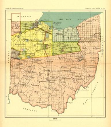
9 Let s Talk History Indian Treaty History Main Treaties Ceding Indian Lands in Ohio/Michigan 1795 Greenville Treaty 16,930,417 Acres 1805 Fort Industry Treaty 2,726,812 Acres 1807 Detroit Treaty 345,600 Acres 1808 Brownstown Treaty Two Roads 1817 Fort Meigs Treaty 4,554,459 Acres 1818 St. Marys Treaties 297,600 Let s Talk History Indian Treaty History Main Treaties Ceding Indian Lands in Ohio/Michigan 1795 Greenville Treaty 16,930,417 Acres 1805 Fort Industry Treaty 2,726,812 Acres 1807 Detroit Treaty 345,600 Acres 1808 Brownstown Treaty Two Roads 1817 Fort Meigs Treaty 4,554,459 Acres 1818 St. Marys Treaties 297,600 9
10 The Treaty of Detroit or the Treaty with the Ottawa, etc was executed by General William Hull, governor of the Michigan Territory. As requested by President Thomas Jefferson he desired the Eastern half of Michigan to be released from Indian Title. General Hull held a council in Detroit with the chiefs and warriors of the Ottawa, Chippewas, Wyandots and Pottwatamies. This treaty covered the first public land to be available in what would become the State of Michigan in One Time Payment of $10,000 $3, to Ottawas $3, to Chippewas $1, to Wyandots $1, to Pottawatamies Forever Annuity of $2,400 (to reservations) $800 to Ottawas $800 to Chippewas $400 to Wyandots $400 to Pottawatamies It is further agreed and stipulated, that the said Indian nations shall enjoy the priviledge of hunting and fishing on the lands ceded as aforesaid, as long as they remain the property of the United States. Beginning at the mouth of the Miami river of the lakes, and running thence up the middle thereof, to the mouth of the great Au Glaize river, thence running due north, until it intersects a parallel of latitude, to be drawn from the outlet of lake Huron, which forms the river Sinclair; thence running north east the course, that may be found, will lead in a direct line, to White Rock, in lake Huron, thence due east, until it intersects the boundary line between the United States and Upper Canada, in said lake, thence southwardly, following the said boundary line, down said lake, through river Sinclair, lake St. Claire, and the river Detroit, into Lake Erie, to a point due east of the aforesaid Miami river, thence west to the place of beginning. 10
11 11


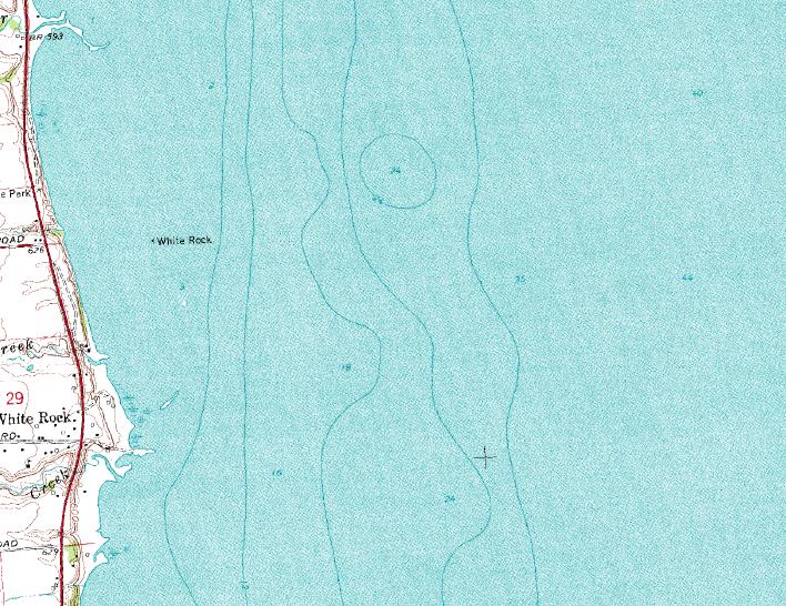
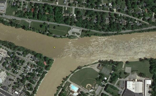
12 White Rock in Lake Huron Detroit Urbanism: Uncovering the History of Our Roads, Borders, and Built Environments. Indian Villages, Reservations, and Removal March 7, 2016 by Paul Szewczyk. World Digital Library 12

13 World Digital Library 13

14 Let s Talk History War of 1812 History Battle between United States and the British Empire -attempt to restrict U.S. Trade and America s desire to expand Lost the Battle at Detroit but won the Battle of Lake Erie because of Commodore Olive Hazard Perry Sept Battle of Lake Erie put the Northwest Territory back in U.S. Control Washington D.C. was burnt on 1814 Key battles were won in New York, Baltimore and New Orleans Treaty of Ghent signed on February 17, 1815 Known as the 2 nd War of Independence national pride soared National Debt went from 80 Million to 125 Million Needed land to fulfill Military Warrants Needed to sell land to pay off national debt 14


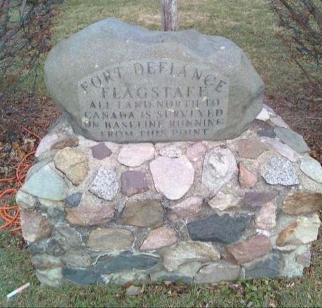
15 Ordered built by General Mad Anthony Wayne 1794 Forts built within a days march from each other Protection from The English, the Indians, and all the devils in hell. according to Lieutenant John Boyer. Northwest Indian War, Tecumseh s War & War of Entire Fort Rebuilt to exact detail Granite Boulder placed at assumed POB (flagstaff). 15
 1804 County")
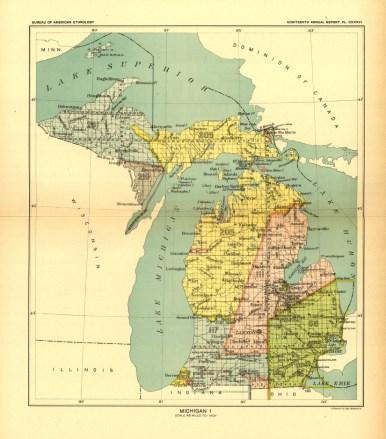
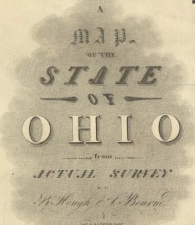
16 Benjamin Hough, DS Alexander Holmes, DS Thomas Evans, DS Allison Looker, DS Nine Other Men to Clear Line, Hunt, Cook & Haul Equipment 1773 Born in Loudon County, VA and Raised in Washington County, PA 1801 Purchased Land in the Seven Ranges at age of Surveyed in Cross Creek Township near Steubenville, OH 1804 Appointed as a General Land Office Deputy Surveyor (31 Years Old) 1804 County Commissioner for Jefferson County, OH 1805 Trustee for City of Steubenville, OH 1805 Ohio Senate 1807 Ohio House of Representatives 1808 State of Ohio Auditor 1810 Moved to Zanesville from Chillicothe new capital 1812 Moved to Chillicothe 1815 Asked to move to Columbus new capital but did not move 1815 Contract to Survey the Michigan Meridian (42 Years Old) 1819 Died at 47 years old A Map of the State of Ohio from Actual Surveys by B. Hough & A. Bourne Published May 01, 1814 Benjamin Hough Alexander Bourne John Melish David Rumsey Map Collection Cartographic Associates 16
17 17
18 18
19 Moved from England 5 Children 19
20 11 Children Surveyor of Lord Fairfax and Landowner Super Wealthy Friend of George Washington Built Corby Hall, Waterford, VA 9 Children, 3 of which became Surveyors 20

21 Surveyor in Virginia, Pennsylvania & Ohio 9 Children Corby Hall Milltown Road, Watertown, VA 21
22 1778 Born and Raised in Washington County, PA 1800 Appointed as a General Land Office Deputy Surveyor (22 Years Old) 1802 Moved to Licking County, OH 1804 Appointed as Licking County Surveyor 1808 Common Pleas Court Judge 1815 Contract to Survey the Michigan Baseline 1815 Contract to Assist B. Hough with the Michigan Meridian (37 Years Old) 1823 Common Pleas Court Judge 1833 Died at 55 years old in Newark, OH Moved from England 22
23 8 Children 14 Children (2 of which became Deputy Surveyors) Not much is known about Thomas Evans other than he held additional contracts to subdivide townships within Michigan. Allison Looker was married to Benjamin Hough s daughter Rachel. He held additional contracts in the State of Indiana. He was also an officer in the war of After Allison passed, Rachel married his brother James Harvey Looker. 23
24 Not much is known about Thomas Evans other than he held additional contracts to subdivide townships within Michigan. Allison Looker was married to Benjamin Hough s daughter Rachel. He held additional contracts in the State of Indiana. He was also an officer in the war of After Allison passed, Rachel married his brother James Harvey Looker. Not much is known about Thomas Evans other than he held additional contracts to subdivide townships within Michigan. Allison Looker was married to Benjamin Hough s daughter Rachel. He held additional contracts in the State of Indiana. He was also an officer in the war of After Allison passed, Rachel married his brother James Harvey Looker. 2 nd Cousin of Abraham Clark Signer of the Declaration of Independence After the War of 1812 the national debt went from 80 million to 125 million. Congress designated an area of land Northwest of Detroit to satisfy military warrants. Also needed the public lands as a source of revenue Needed to be surveyed first! Indian Hostilities elsewhere & confusion of Indian Treaty Line 24
25 Let the two million acres in Michigan be as near the north boundary of OHIO & the western shore of Lake Erie, as convenient. The northern boundary of Ohio not having yet been determined, you will be careful not to extend the surveys so far south as to encroach on that boundary. Josiah Meigs*, March 23, 1815 *Meigs was Commissioner of the General Land Office in 1815 In October 1814 Josiah Meigs and Edward Tiffin switched jobs. Meigs became Commissioner and Tiffin became Surveyor General. Meigs did not like Cincinnati and Tiffin did not like Washington D.C. Tiffin was the first Commissioner of the GLO as created in April Act of December 24, 1811 & January 11, 1812 provided that military bounties of 160 acres would be given to each soldier who had faithfully served in the armed forces in the war with Great Britain Act of May 06, 1812 That the President of the United States be, and he is hereby authorized to cause to be surveyed a quantity of the public lands of the United States, fit for cultivation, not otherwise appropriated, and to which the Indian title is extinguished, not exceeding in the whole six millions of acres, two millions to be surveyed in the territory of Michigan Alexander Holmes had contract for Michigan Baseline, but could not survey it due to Indian hostility. He tried, but had to turn back and return to Detroit. Benjamin Hough also had contract for the sections along the road between Fort Meigs and the Western Reserve. He also could not survey it due to the Indian hostility. Once again he tried, but had to turn back. The surveyors found out that the Indian Hostility was due to a confusion of the Indian Treaty Line they thought it went on a straight line from Fort Defiance to White Rock. 25
26 Indian Opposition led by Chief Tarhe, the Crane. A distinguished Wyandot Chief and Loyal American Leading spirit at the Treaty of Greenville in 1795 Born in Detroit in 1742, member of the Porcupine clan Fought in the Battle of Thames at 72 years old His name came because of his height and slender build. The French translation means at him or at the tree. Tarhe married a French Canadian with daughter named Myerrah (White Crane) White Crane married Isaac Zane who founded Zanesville. The book Betty Zane was about Isaac and his brother Ebenezer Tarhe moved around a lot and lived mostly in Logan County and along the Hocking River. He died in November of 1816 at Cranetown in Upper Sandusky, Ohio Funeral was the largest ever known for an Indian Chief Benjamin Hough and Alexander Holmes joined forces and decided to survey the Indian Treaty Line, but to also survey the Michigan Meridian and establish and run the Michigan Baseline all in one season - actually in 3 months. The theory is they went to the baseline and calculated the latitude (or relied on latitude as observed by Woodward. Hough calculated the N. Cape of Maumee Bay to determine N. Line of Ohio then they traveled to Fort Defiance and calculated the latitude there. Then they could run North without backtracking South and fulfill both of their contracts together. This sounded good, but this did NOT work in the end! 26

27 March 9, 1815 Tiffin proposed surveys be started April 1815 Tiffin contracted with Hough April 1815 Tiffin contracted with Holmes May 1815 Hough measured lat. at N. Cape September 29, 1815 Field work started October 1815 Alexander and Samuel met up November 1815 Survey work ceased July 16, 1816 Survey work resumed According to Thomas Freeman there are two ways to determine Due North 1. To determine the variation of the magnetic needle note exactly by a good watch when the Polar Star and the first [star, Alioth] in the tail of the great Bear (or star next the Square) are vertical to each other, or range with a Plumb line. Ten minutes after wards the polar Star will be on the [t]rue meridian a Stake or Small light placed at that time in a right [true] line with the Plumb line and the Polar Star will point out a true meridian. 2. The most convenient, practical & accurate mo[de] for Surveyors to ascertain the Variation of the needle will be by the polar Star s greatest Elongation which will be visible from the first of November to the first of March (& to) the West and from the first of May to the first of Sept. to the East. Brackets by Owens Volume 10, Fall 2014 Turning the Horizon MSPS GLO Procedures for Astronomical Observation by Jack Owens Thomas Freeman Instructions to the Principal Deputy Surveyor of the Land District East of Island of N. Orleans 1819 Micajah T. Williams General Instructions to His Deputies; By the Surveyor General of the United States, for the States of Ohio and Indiana, and the Territory of Michigan 27
28 According to Thomas Freeman there are two ways to determine Due North 1. To determine the variation of the magnetic needle note exactly by a good watch when the Polar Star and the first [star, Alioth] in the tail of the great Bear (or star next the Square) are vertical to each other, or range with a Plumb line. Ten minutes after wards the polar Star will be on the [t]rue meridian a Stake or Small light placed at that time in a right [true] line with the Plumb line and the Polar Star will point out a true meridian. 2. The most convenient, practical & accurate mo[de] for Surveyors to ascertain the Variation of the needle will be by the polar Star s greatest Elongation which will be visible from the first of November to the first of March (& to) the West and from the first of May to the first of Sept. to the East. Thomas Freeman was a famous astronomer & surveyor from 1792 to He was a good personal friend of George Washington and worked as his land agent and also collected rents and secured payments for land Washington sold. Washington appointed Freeman to survey the US/Spain boundary in 1796 and from surveyed much of the Northwest Territory. In 1806 he was chosen to survey the Red River Expedition by Thomas Jefferson. Volume 10, Fall 2014 Turning the Horizon MSPS GLO Procedures for Astronomical Observation by Jack Owens Thomas Freeman Instructions to the Principal Deputy Surveyor of the Land District East of Island of N. Orleans 1819 Micajah T. Williams General Instructions to His Deputies; By the Surveyor General of the United States, for the States of Ohio and Indiana, and the Territory of Michigan According to Micajah Williams, from 1833, he cites Freeman s first method. The star commonly called the North Star, is not directly north but revolves round the pole in a small circle, once in 24 hours. It can therefore be due north only twice in that period; and that is within a very few minutes of the time, when a star, called Alioth in the constellation of Ursa major, or the great bear, is directly over or under it. There is also another star nearly in an opposite direction from the pole, called Gamma, in the constellation of Cassiopeia. When these three stars are vertical, the north star is very near the meridian. Volume 10, Fall 2014 Turning the Horizon MSPS GLO Procedures for Astronomical Observation by Jack Owens Thomas Freeman Instructions to the Principal Deputy Surveyor of the Land District East of Island of N. Orleans 1819 Micajah T. Williams General Instructions to His Deputies; By the Surveyor General of the United States, for the States of Ohio and Indiana, and the Territory of Michigan According to Micajah Williams, from 1833, he cites Freeman s first method. The star commonly called the North Star, is not directly north but revolves round the pole in a small circle, once in 24 hours. It can therefore be due north only twice in that period; and that is within a very few minutes of the time, when a star, called Alioth in the constellation of Ursa major, or the great bear, is directly over or under it. There is also another star nearly in an opposite direction from the pole, called Gamma, in the constellation of Cassiopeia. When these three stars are vertical, the north star is very near the meridian. Micajah T. Williams was the Surveyor General from Volume 10, Fall 2014 Turning the Horizon MSPS GLO Procedures for Astronomical Observation by Jack Owens Thomas Freeman Instructions to the Principal Deputy Surveyor of the Land District East of Island of N. Orleans 1819 Micajah T. Williams General Instructions to His Deputies; By the Surveyor General of the United States, for the States of Ohio and Indiana, and the Territory of Michigan 28
29 I believe that Hough used both methods for determining Due North. Owens believes that Hough used the 2 nd method and that if timed right during September - October and March-April the elongation could be observed during the same evening. Owens writes that Hough s double observation fits the first time frame, Western Elongation early in the evening followed 12 hours later by Eastern Elongation early in the morning. We arrived at Fort Defiance on the 29 th Ult. And obtained a very satisfactory observation of the polar star when at its greatest elongation, both East and West, and also when on the Meridian, two nights in succession, and found from each observation (both exactly agreeing), that the variation of the compass at that place, was 4 39 East, and by that variation ran the meridian line. Freeman To determine the variation of the magnetic needle note exactly by a good watch when the Polar Star and the first [star, Alioth] in the tail of the great Bear (or star next the Square) are vertical to each other, or range with a Plumb line. Ten minutes after wards the polar Star will be on the [t]rue meridian a Stake or Small light placed at that time in a right [true] line with the Plumb line and the Polar Star will point out a true meridian. Williams The star commonly called the North Star, is not directly north but revolves round the pole in a small circle, once in 24 hours. It can therefore be due north only twice in that period; and that is within a very few minutes of the time, when a star, called Alioth in the constellation of Ursa major, or the great bear, is directly over or under it. There is also another star nearly in an opposite direction from the pole, called Gamma, in the constellation of Cassiopeia. When these three stars are vertical, the north star is very near the meridian. We arrived at Fort Defiance on the 29 th Ult. And obtained a very satisfactory observation of the polar star when at its greatest elongation, both East and West, and also when on the Meridian, two nights in succession, and found from each observation (both exactly agreeing), that the variation of the compass at that place, was 4 39 East, and by that variation ran the meridian line. Freeman 1. The most convenient, practical & accurate mo[de] for Surveyors to ascertain the Variation of the needle will be by the polar Star s greatest Elongation which will be visible from the first of November to the first of March (& to) the West and from the first of May to the first of Sept. to the East. We arrived at Fort Defiance on the 29 th Ult. And obtained a very satisfactory observation of the polar star when at its greatest elongation, both East and West, and also when on the Meridian, two nights in succession, and found from each observation (both exactly agreeing), that the variation of the compass at that place, was 4 39 East, and by that variation ran the meridian line. 29

30 We arrived at Fort Defiance on the 29 th Ult. And obtained a very satisfactory observation of the polar star when at its greatest elongation, both East and West, and also when on the Meridian, two nights in succession, and found from each observation (both exactly agreeing), that the variation of the compass at that place, was 4 39 East, and by that variation ran the meridian line. 30
31 31
32 32
33 33

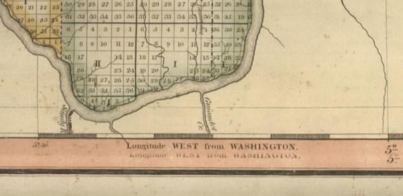
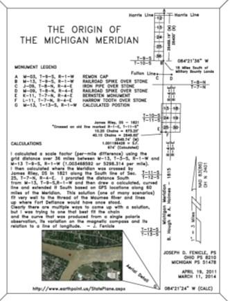
34 Used with Permission from Paul Sewick Things get real confusing Hough heads back to Ohio on Oct. 20 th due to illness. Alexander and Samuel keep surveying until late November then stop Hough comes back in January/February of 1816 to set Initial Point 1819 Saginaw Treaty gives Wampler Contract Wampler comes into the picture in 1824 and sets second initial point against his instructions to use Hough s previously set corners creating Chain Jog Chains = Feet Wampler s Corner = Baseline West as set on or near January 19, 1824 (South Corner) Hough s Corner = Baseline East as set in 1816 (North Corner) 34
35 Not without controversy even in 1815! Unsigned Letter to Josiah Meigs August 26, 1815 Dear sir; I wish Government to be informed through you that Mr. Benjamin Hough has by some means insinuated himself in favor with Surveyor General Tiffin & has got for himself and a parcel of boys he has about him nearly all the public surveying. Hough was a while Auditor of this State and from his errors and inability was put out last session. Mr. Tiffin not being himself a judge has been grossly imposed on by this Hough, who is not a mathematician & yet pretends to everything, & has got the mathematical instruments that was purchased by the United States at a great price, pretending to make observations with them and has left part of them at the lake when discharged by the indians. You may rely sir that he never saw a quadrant before he saw one of Mr. Spencers about a year ago. He is a complete imposter from the eastern states & is pretending & has together nearly all the instruments. You well know I suppose, or the Government knows or ought to know that Mr. Tiffin knows nothing about these things & has suffered himself to be blinded to these fellows to the injury to the U. States. I hope you will make it known to government & that Mr. Tiffin might be cautioned on the subject. If notice is not immediately taken of this I shall inform government publicly, exposing the fact within the National Intelligence. I think it my duty that such men ought to be exposed. For the reality of this statement you had better inquire of Mr., or some man acquainted with the abilities of this B. Hough, for there never was a man more deceived than Mr. Tiffin to entrust such a man with the instruments that is not even a mathematician. The thing is absurd and ridiculous. I am, etc. (no signature) Not without controversy even in 1815! Unsigned Letter to Josiah Meigs August 26, 1815 Dear sir; I wish Government to be informed through you that Mr. Benjamin Hough has by some means insinuated himself in favor with Surveyor General Tiffin & has got for himself and a parcel of boys he has about him nearly all the public surveying. Hough was a while Auditor of this State and from his errors and inability was put out last session. Mr. Tiffin not being himself a judge has been grossly imposed on by this Hough, who is not a mathematician & yet pretends to everything, & has got the mathematical instruments that was purchased by the United States at a great price, pretending to make observations with them and has left part of them at the lake when discharged by the indians. You may rely sir that he never saw a quadrant before he saw one of Mr. Spencers about a year ago. He is a complete imposter from the eastern states & is pretending & has together nearly all the instruments. You well know I suppose, or the Government knows or ought to know that Mr. Tiffin knows nothing about these things & has suffered himself to be blinded to these fellows to the injury to the U. States. I hope you will make it known to government & that Mr. Tiffin might be cautioned on the subject. If notice is not immediately taken of this I shall inform government publicly, exposing the fact within the National Intelligence. I think it my duty that such men ought to be exposed. For the reality of this statement you had better inquire of Mr., or some man acquainted with the abilities of this B. Hough, for there never was a man more deceived than Mr. Tiffin to entrust such a man with the instruments that is not even a mathematician. The thing is absurd and ridiculous. I am, etc. (no signature) Did they actually survey thru Ohio when it didn t even really matter? 35


36 Did they actually survey thru Ohio when it didn t even really matter? The evidence says YES Book 3 ½, Cover Book 3 ½, Page 4 36
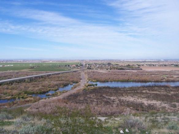
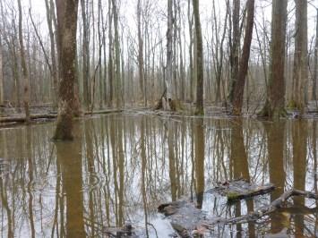
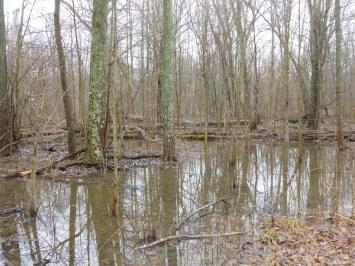
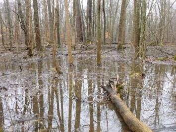
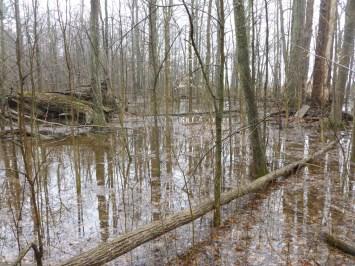
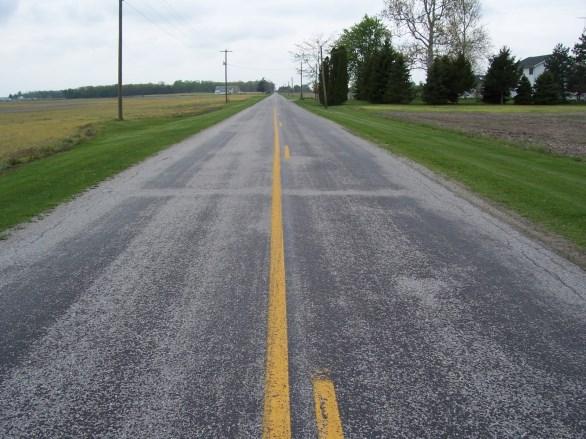
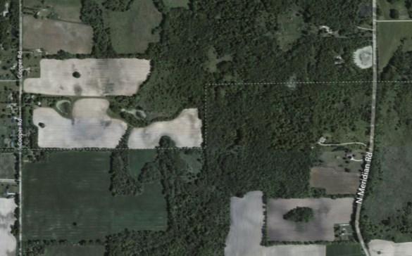
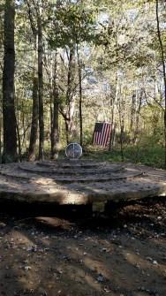
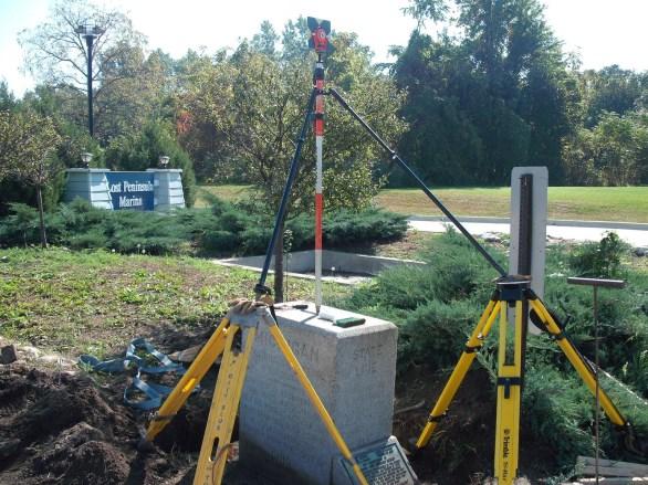
 crossing the Miami of Lake Erie to the North bank")

37 Commenced the Meridian, or Indian boundary line, Beginning at the Mouth of the Great Auglaize river and run by the true meridian due North (the Variation being 4 39 East) crossing the Miami of Lake Erie to the North bank of the Miami; being the width of that river and the width of the great Auglaize being and from the point of Beginning (on the west shore bears S31W, up, and the south shore of the Miami upwardly, bears West, Book 3 ½, Page 4 37

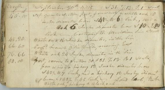
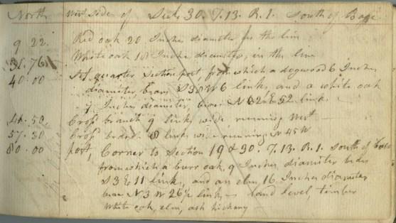
38 Book 3 ½, Page 5 Book 3 ½, Page 6 38


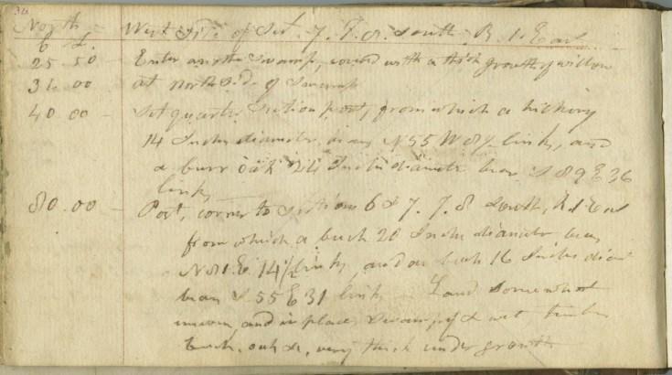
39 Book 3 ½, Page 7 Book 3 ½, Page 39 39

40 East On Random between Sect Crossed an old line marked R 1 E, T 11 S an Elm 20 in. diam. James Riley, DS
41 41
 15,378")


42 Branch 20 Links Wide Running S 45 W Book 3 ½, Page 10 Peterson Ditch 233 Chains (R) 15,378 Feet (R & M +/-) Cross Branch 20 Links Wide Running West Book 3 ½, Page 7 Tanby Ditch 207 Chains (R) 13,662 Feet (R & M +/-) 1907 Defiance Quadrangle Measurements by Google Earth Book 3 ½, Page 29 42

43 Michigan Meridian 43
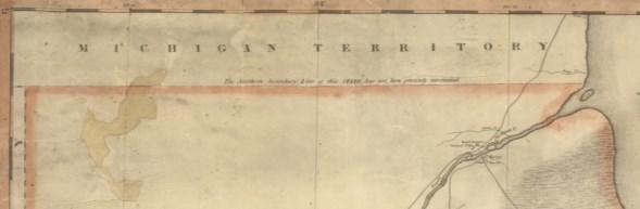
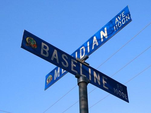
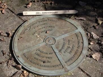
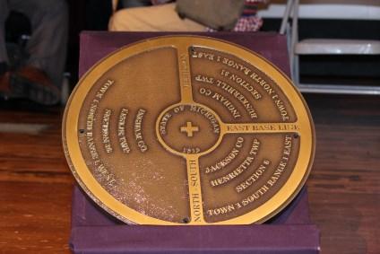
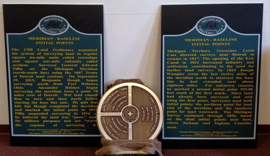
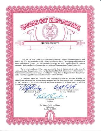
44 44
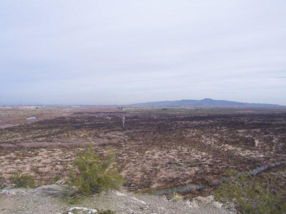
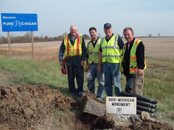
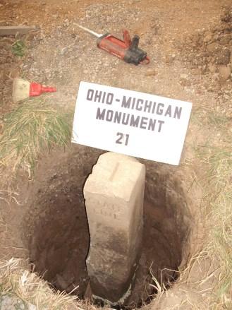
45 What the Michigan Meridian looks like today. 45

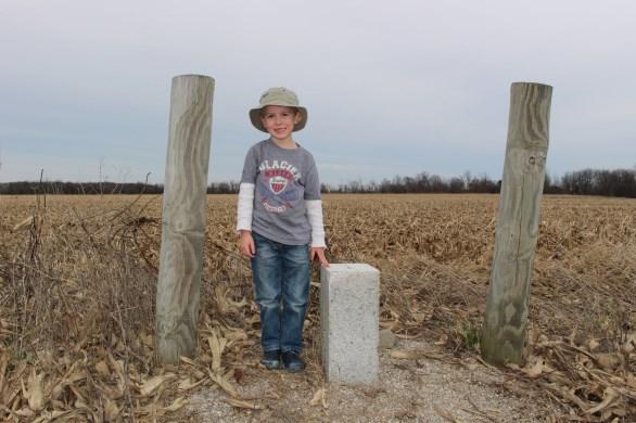
46 46
47 47


48 Pleasant Lake Quadrangle 48
49 ? 49

50 1815 Surveying Michigan Group 50
51 51
52 52

53 Administered by the Ohio Historical Society Vital educational tool to inform residents and visitors about significant aspects of Ohio s past. The markers identify, commemorate, and honor the important people, places and events that have contributed to Ohio s rich history. Standards are set to ensure historical significance and historically accuracy. Be associated with events that have made a significant contribution to broad patterns of history. Be associated with persons no longer living who have made significant contributions to patterns of history and culture. Embody the distinctive characteristics of a type, style, period, method of construction, architecture, or represent the work of a master. Yield, or be likely to yield, information important in prehistory or history. Be associated with ethnic groups who have made distinctive and significant contributions to history. Embody characteristics of the state representing significant aspects of the physical or natural history of the earth and its life. Represent popular stories or myths that, although not verifiable, are significant to history and culture. 53
54 Title of Marker Classification Location of the Proposed Marker Owner of the Property upon which the marker is to be erected Type of Marker Funding sponsor of the marker Maintenance of the marker Shipping Address Statement of Significance Suggested Marker Text Annotated Bibliography Application Submitted By May 24, 2012 May 21, 2013 March 17, 2014 NW PLSO Central MSPS Toledo PLSO NW PLSO = $ Central MSPS = $ Toledo PLSO* = $ $ *Toledo PLSO made an additional motion to donate an undetermined amount for construction materials and to help fund future maintenance. It all began with the signing of the Treaty of Detroit on November 17, 1807 by the Chippewas, Ottawas, Wyandots and Pottawatamies. The tribes ceded approximately 345,600 Acres between Detroit and the Auglaize River and east of a line drawn due north from Fort Defiance. Prior to the War of 1812 the Secretary of the Treasury, Albert Gallatin, limited the national debt to 80 million dollars. After the war the debt inflated to about 125 million dollars and a need for revenue was apparent. Congress, in addition to needing land for military warrants, was also going to sell the land as ceded from the tribes. On March 9, 1815 Surveyor General Edward Tiffin proposed to the Commissioner of the General Land Office, Josiah Meigs that surveying be started. In April of 1815 Tiffin contracted with Benjamin Hough to survey the Meridian from Fort Defiance north to the baseline at a rate of $3.00 per mile. The survey was started September 29, 1815 by Benjamin Hough, assistant Alexander Holmes, Hough s son in law Allison Looker, Thomas Evans and about 9 other men helping to clear line, hunt, cook and haul equipment. The crew ran north from Fort Defiance for 42 miles before branching in different directions. The 42 nd mile marked the southwest corner of the proposed 2 million acres of military lands. Until this point most of the meridian actually fell in Ohio and most notably the disputed territory which prompted the Toledo War. In November of 1815 the surveys ceased due to poor field conditions and the lack of promise to provide soldiers with land fit for cultivation (officially suspended on April 2, 1816). Surveys did not resume until July 16, 1816 and when completed created a confusing second initial point. The Michigan Meridian and accompanying baseline control all townships and ranges across the state of Michigan and that portion that now lies within Ohio. The quality of work and the hardships that the survey crew endured while surveying the meridian shall be remembered and honored. The Michigan Meridian is only part of the vast public land survey system that spans the western United States. 54
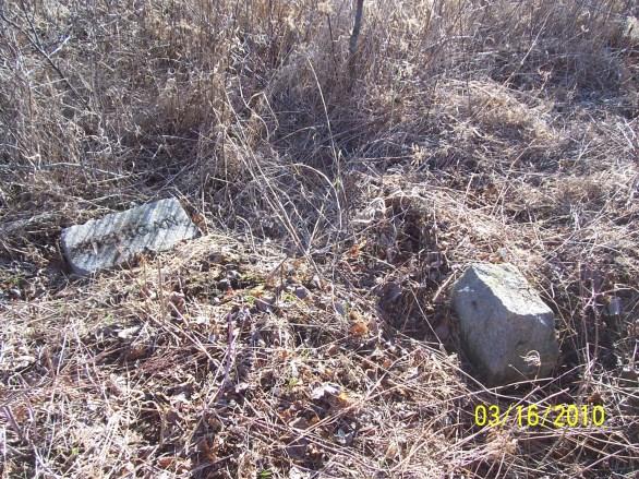
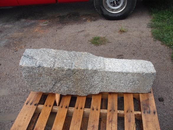
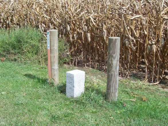
55 1815 MICHIGAN MERIDIAN After the War of 1812, the United States Congress proposed two million acres of military bounty land for the Michigan Territory. To survey the land, the meridian had to first be established. U.S. Surveyor General Edward Tiffin created the meridian based on the western line of the Treaty of Detroit (1807). He contracted with Deputy Surveyor Benjamin Hough in April 1815 to begin the survey for $3 per mile. Taking a reading from Polaris (the North Star), Hough, Alexander Holmes, and 11 crew members surveyed the line due north from Fort Defiance. The difficult terrain they encountered temporarily halted all surveys in the territory and ultimately led to the bounty land being transferred to the Illinois and Missouri Territories. In 1787 when the Northwest Ordinance was drafted based on an inaccurate map drawn by geographer John Mitchell, the problems began. Ohio thought the language from the Ordinance drawing an East-West line from the southern tip of Lake Michigan included present day Toledo and the Mouth of the Maumee River. The Michigan Territory held the Ordinance Line and when surveyed Ohio found the problem and changed their constitution to read a line drawn directly from Lake Michigan s southern extremity to the most northerly cape of the Miami (Maumee)Bay. Commonly known as the Harris Line, William Harris surveyed the line based upon Ohio s Constitution. John Fulton, as ordered by the Michigan Territory, surveyed the Ordinance Line, or Fulton Line and officially created the Toledo Strip. After the bloodless Toledo War and sour feelings on both sides Ohio was granted the 400 square miles of the Toledo Strip and by order of President Andrew Jackson granted Michigan Statehood and was granted 9000 square miles of the Upper Peninsula. As originally surveyed by William Harris in 1817, retraced by The Ohio Boundary Commissioners Surveyors and again retraced by General Land Office Surveyor Andrew Porter the line was finally permanently retraced and monumented by Samuel Stinson Gannett and crew in The 48 th Legislature of Michigan approved Act 84 of the Public Acts of 1915 and the 81rst General Assembly of Ohio approved House Bill 701 to jointly finance the survey. The survey resulted in 72 granite monuments being set over miles between July 12 and October 26, The entire survey cost $7, or $ per mile and was known as one of the cheapest state line retracement surveys ever performed, yet one of the most accurate. The monuments came from the largest open face granite quarry in the world Mount Airy, North Carolina. The monuments were shipped to Toledo and the top 18 inches were dressed and cut by Lloyd Walker Brothers of Toledo. S.S. Gannett, Geographer of the United States Geological Survey was known as a state line boundary retracement specialist. Over his career he surveyed the state lines between New Hampshire/Vermont, Maryland/West Virginia, North Carolina/Tennessee and Idaho/Washington. He was the son of the Henry Gannett, Chief Geographer of the United States Geological Survey. The Ohio-Michigan Boundary settled one of the most deeply disputed state lines in the United States. The granite monuments still exist today and when checked with modern survey instrumentation one can only marvel at the accuracy used to run and establish this historic state line OHIO MICHIGAN STATE LINE SURVEY Between July 12 and October 26, 1915, Samuel Stinson Gannet, Geographer of the United States Geological Survey and crew retraced and surveyed the Ohio and Michigan State Line. Working with a transit and dragging a 300 foot steel tape, the crew surveyed miles and set 72 granite monuments. The 700-pound monuments are 5 feet 6 inches tall and cost $18.00 each, including delivery from Mount Airy, North Carolina. The top 18 inches were cut and carved by Lloyd Brothers in Toledo. Once the survey was complete, it put an end to one of the greatest disputes over a state line in the history of the United States. 55
56 60 R/W Post R/W 56


57 Copyright David Green, State Line Observer 57

58 THANK YOU 58


59 59
60 60
HONORING THE SURVEY OF THE MICHIGAN MERIDIAN
 HONORING THE SURVEY OF THE MICHIGAN MERIDIAN Submitted by Joseph Fenicle, PS On November 17, 1807 a line was described as the Western line of the Treaty of Detroit. This line would become the Michigan
Ohio & Michigan Boundary Posts
 Ohio & Michigan Boundary Posts History, Recovery & Preservation As originally surveyed by Samuel Stinson Gannett and Crew between July and October 1915 Joseph D. Fenicle, PS Ohio & Michigan Professional
SURVEYING ECONOMICS. Thought Leader Our own worst enemy. Surveying History Following the footsteps. Decided Guidance Staying within your survey
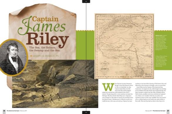
 FEBRUARY 2017 SURVEYING ECONOMICS Thought Leader Our own worst enemy Surveying History Following the footsteps Decided Guidance Staying within your survey James Captain Riley The Sea, the Sahara, the Swamp
Document Based Question. Evaluate the changes in America ideology and policy towards American Indians between the time period of
 Document Based Question Evaluate the changes in America ideology and policy towards American Indians between the time period of 1763-1835. Document 1 The Royal Proclamation of 1763 King George And whereas
DECEMBER 2016 MT. SOLEDAD. GLO Surveying Short cut method. Decided Guidance Obeying our Oath. Train Surveying Rapid data
 DECEMBER 2016 MT. SOLEDAD GLO Surveying Short cut method Train Surveying Rapid data Decided Guidance Obeying our Oath The Short Cut Method» JERRY PENRY, PS n certain areas of the country, the surveyors
THE LATE GREAT PUGET SOUND MERIDIAN. Washington State s Own Principal Meridian. by Denny DeMeyer
 THE LATE GREAT PUGET SOUND MERIDIAN. Washington State s Own Principal Meridian by Denny DeMeyer Pausing briefly in a clearing in the forest while ascending a ridge just south of Bellingham, the surveyors
Why is the Treaty at Logstown in 1748 so important? What did it do?
 Student Worksheet A Shot in the Backwoods of Pennsylvania Sets the World Afire Worksheet 1: Focus Questions for "The Roots of Conflict" Instructions: Your group may answer these questions after the reading
United States History. Robert Taggart
 United States History Robert Taggart Table of Contents To the Student.............................................. v Unit 1: Birth of a Nation Lesson 1: From Colonization to Independence...................
Name: Class Period: Date:
 Name: Class Period: Date: Unit #2 Review E George Washington H Jay s Treaty D Pinckney s Treaty G Treaty of Greenville K Whiskey Rebellion B Marbury v. Madison A. The greatest U.S. victory in the War of
The General William Henry Harrison Trail through Portions of Vermillion County and Warren County, Indiana Written 11 October 2015 by Curtis L.
 The General William Henry Harrison Trail through Portions of Vermillion County and Warren County, Indiana Written 11 October 2015 by Curtis L. Older Five Probable Points Along the Harrison Trail, including
Old Sandy Baptist Church Graveyard
 Old Sandy Baptist Church Graveyard By Dave Hallemann This original church cemetery is located in T41 R4 Survey 2018 in what was at one time called the Upper Sandy Settlement off Highway 21. It was visited
Chapter 3: Many Flags over Iowa
 Chapter 3: Many Flags over Iowa CONTENT OBJECTIVES IOWA PAST TO PRSENT TEACHERS GUIDE Revised 3 rd Edition Following the completion of the readings and activities for this chapter, students will have acquired
Southern Campaigns American Revolution Pension Statements & Rosters
 Southern Campaigns American Revolution Pension Statements & Rosters Pension application of John Might W4548 Keranhappack Might f50sc Transcribed by Will Graves 6/21/09: rev'd 4/10/17 [Methodology: Spelling,
History Kids LET US IN! Statehood FOR MICHIGAN MICHIGAN FOR SPRING 2001
 MICHIGAN History History Kids SPRING 2001 FOR LET US IN! Statehood FOR MICHIGAN What s INSIDE... Features: We Want In!...4 Toledo, Michigan?...9 How They Got Here...10 Coming to Michigan...12 Elsewhere
2008 SURVEY OF INDIANA COUNTY SURVEYORS
 THE COUNTY SURVEYOR: 2008 SURVEY OF INDIANA COUNTY SURVEYORS 1. Are you a Registered Land Surveyor or Professional Engineer? a. REGISTERED LS b. PE c. BOTH d. NEITHER 2. Is your position as County Surveyor
Chapter 8 From Colony to Territory to State
 Chapter 8 From Colony to Territory to State Standard 2 Key Events, Ideas and People: Students analyze how the contributions of key events, ideas, and people influenced the development of modern Louisiana.
Historic Waynesborough collection
 01 Finding aid prepared by Celia Caust-Ellenbogen and Sarah Leu through the Historical Society of Pennsylvania's Hidden Collections Initiative for Pennsylvania Small Archival Repositories. Last updated
Early Adventures at Put-in-Bay, Middle Bass and Johnson s Island Copyright 2008 by Michael Gora
 Early Adventures at Put-in-Bay, Middle Bass and Johnson s Island Copyright 2008 by Michael Gora Cover Note: The two images on the bottom of the cover show Put-in-Bay harbor around 1865. In the image on
Tecumseh. Tecumseh. This article is provided courtesy of History.com
 Tecumseh Tecumseh This article is provided courtesy of History.com Shawnee Indian political leader and war chief Tecumseh (1768 1813) came of age amid the border warfare that ravaged the Ohio Valley in
Ipperwash: General Historical Background
 1 Ipperwash: General Historical Background Joan Holmes & Associates, Inc. Sketch from Field Book of Surveyor M. Burwell, 1826. Native Peoples (circa, 1740) 2 The ancestors of the Kettle and Stony Point
S T A T E O F M I C H I G A N BOARD OF COMMISSIONERS OF THE COUNTY OF ALLEGAN. May 26, 2016
 143-798 S T A T E O F M I C H I G A N BOARD OF COMMISSIONERS OF THE COUNTY OF ALLEGAN May 26, 2016 BOARD OF COMMISSIONERS APPROVE PARTIAL RELEASE PROTECTIVE COVENANTS WHEREAS, on May 2, 2016, the Allegan
664 INDIANA HISTORICAL COLLECTIONS
 664 INDIANA HISTORICAL COLLECTIONS PIKE COUNTY I DECEMBER 21, 1816: Formation by statute, effective February 1, 1817. The formation affected Gibson and Perry counties. BOUNDARIES: "Beginning at a point
Genealogy and NORTH CAROLINA Counties
 1 Genealogy and NORTH CAROLINA Counties An ancestor blessed with longevity could have been born in Rowan County in 1753. married in Burke County in 1778, fathered children in the counties of Burke and
TruthQuest History American History for Young Students II ( ) Maps, Timeline & Report Package
 Maps, Timeline & Report Package") 1 A J T L Grades 1 and up TruthQuest History American History for Young Students II (1800-1865) Maps, Timeline & Report Package A Journey Through Learning www.ajourneythroughlearning.com 2 Please check
1 A J T L Grades 1 and up TruthQuest History American History for Young Students II (1800-1865) Maps, Timeline & Report Package A Journey Through Learning www.ajourneythroughlearning.com 2 Please check
HENRY¹ OF HINGHAM Sixth Generation
 HENRY¹ OF HINGHAM Sixth Generation No. 417 NAME: Stout⁶ Chamberlin Father: Richard⁵ Chamberlin (No. 218) [John⁴ (Henry³, John², Henry¹) and Rebecca (Morris) Chamberlin] Mother: Mary Stout Born: 1 May 1757,
Parts one and two of the transcriptions of the documents within the Elena Gallegos Land Grant papers
 The Elena Gallegos Land Grant Part III by Henrietta M. Christmas and Angela Lewis Parts one and two of the transcriptions of the documents within the Elena Gallegos Land Grant papers can be found in the
Circuit Court, D. Iowa
 YesWeScan: The FEDERAL CASES Case No. 1,142. [5 Dill. 549.] 1 BAYLISS V. POTTAWATTAMIE COUNTY. Circuit Court, D. Iowa. 1878. DEDICATION OF PUBLIC SQUARE IOWA STATUTE ESTOPPEL. The public square in the
THE CODIFIED ORDINANCES OF THE CITY OF AVON REGARDING MINIMUM YARD REQUIREMENTS FOR ACCESSORY STRUCTURES
 MONDAY, JULY 13, 2015 PUBLIC HEARINGS: 7:15 P.M. ORDINANCE NO. 72-15 AN ORDINANCE AMENDING SECTION 1262.08(c) OF THE CODIFIED ORDINANCES OF THE CITY OF AVON REGARDING MINIMUM YARD REQUIREMENTS FOR ACCESSORY
Copyright 2016 by Gary Boden and the Exeter Historical Association
 The Horn Heap Among the landmarks of Exeter, there s a nearly forgotten one with a strange alliterative name. It s called the Horn Heap and its story goes back to the very earliest days of the Rhode Island
Tennessee State Library and Archives
 Box 1 -- Folder 1 Tennessee State Library and Archives LETTERS OF THE TENNESSEE GOVERNORS JOHN SEVIER 1796-1801 ( Part 1 ) NAME YEAR PLACE INCOMING OUTGOING SUBJECT Smith, Daniel (Gen.) 1791 Philadelphia,
Social Studies Chapter 11 Study Guide. People/Places/Terms to Know
 Social Studies Chapter 11 Study Guide Essays electoral college inauguration Cabinet political party first 2 political parties Pierre L Enfant Benjamin Banneker Abigail Adams George Washington Thomas Jefferson
 LAND GRANT DOCUMENT THOMAS ETHRIDGE, ROBERT CRANTON. January 9, 1832 WILLIAM THE FOURTH, by the Grace of God, of the United Kingdom of Great- Britain and Ireland, King, Defender of the Faith, and of the
Dear Sir and Father, We treated them as such, and then waited to see what they would do.
 MEMORIAL TO SIR WILFRID LAURIER, PREMIER OF THE DOMINION OF CANADA FROM THE CHIEFS OF THE SHUSWAP, OKANAGAN AND COUTEAU TRIBES OF BRITISH COLUMBIA. PRESENTED AT KAMLOOPS, B.C. AUGUST 25, 1910 Dear Sir
Chapter 3. Alabama: Territory & State
 Chapter 3 Alabama: Territory & State Lesson 1 (page 71) 13 Colonies began to object the way the British king and Parliament made rules for them. France & Spain helped the colonies win the war. BrainPOP
A. A. (ALPHONSO ALBERT) COLE PAPERS,
 COLE PAPERS,") Collection # M 0586 OM 0263 A. A. (ALPHONSO ALBERT) COLE PAPERS, 1836-1862 Collection Information Biographical Sketch Scope and Content Note Box and Folder List Cataloging Information COLLECTION INFORMATION
Collection # M 0586 OM 0263 A. A. (ALPHONSO ALBERT) COLE PAPERS, 1836-1862 Collection Information Biographical Sketch Scope and Content Note Box and Folder List Cataloging Information COLLECTION INFORMATION
Boone County Commission Minutes 1 December December Session of the December Adjourned Term. Boone County Government Center Commission Chambers
 TERM OF COMMISSION: PLACE OF MEETING: PRESENT WERE: December Session of the December Adjourned Term Boone County Government Center Commission Chambers Presiding Commissioner Don Stamper District I Commissioner
Missouri. Copyright 2010 LessonSnips
 Missouri Missouri is located in the Midwest, surrounded by the states of Iowa to the north; Nebraska, Kansas and Oklahoma to the west; Arkansas to the south; and Illinois and Kentucky to the east. The
Speech to Governor William Harrison, By Chief Tecumseh, of August 11, 1810 (Excerpted)
") 1 2 3 4 5 6 7 8 9 10 11 12 13 14 15 16 17 18 19 20 21 22 23 24 25 26 27 28 29 30 31 32 33 Speech to Governor William Harrison, By Chief Tecumseh, of August 11, 1810 (Excerpted) Brother, I wish you to give
1 2 3 4 5 6 7 8 9 10 11 12 13 14 15 16 17 18 19 20 21 22 23 24 25 26 27 28 29 30 31 32 33 Speech to Governor William Harrison, By Chief Tecumseh, of August 11, 1810 (Excerpted) Brother, I wish you to give
Wenatchee Indians Ask Justice 21
 WENATCHEE INDIANS ASK JUSTICE An early Indian name for the Wenatchee River was Pisquouse and that name was also used for a tribe of Indians in that vicinity. Probably the first time the river was mapped
Washington Monument Written by Julia Hargrove
 Washington Monument Written by Julia Hargrove Illustrated by Gary Mohrman Teaching & Learning Company 1204 Buchanan St., P.O. Box 10 Carthage, IL 62321-0010 Table of Contents George Washington as a Child
HISTORIC AMERICAN ENGINEERING RECORD WYMAN BRIDGE HAER NO. AR-38. UTM: 15/ / Quad: Elkins, Arkansas. Washington County, Arkansas
 HISTORIC AMERICAN ENGINEERING RECORD WYMAN BRIDGE LOCATION: Spanning the White River on Washington County Road 48 near Fayetteville, Washington County, Arkansas. UTM: 15/3992390/402650 Quad: Elkins, Arkansas
CHAPTER 8 CREATING A REPUBLICAN CULTURE, APUSH Mr. Muller
 CHAPTER 8 CREATING A REPUBLICAN CULTURE, 1790-1820 APUSH Mr. Muller AIM: HOW DOES THE NATION BEGIN TO EXPAND? Do Now: A high and honorable feeling generally prevails, and the people begin to assume, more
JOSEPH WIKERSON, SCIPIO, AND HC. I don t know what HC stands for! In all my searching, all these years, I have
 JOSEPH WIKERSON, SCIPIO, AND HC I don t know what HC stands for! In all my searching, all these years, I have found no document or evidence to suggest what these initials mean. I start with this point
OSHTEMO CHARTER TOWNSHIP ZONING BOARD OF APPEALS MINUTES OF A SPECIAL MEETING HELD JUNE 12, 2014
 OSHTEMO CHARTER TOWNSHIP ZONING BOARD OF APPEALS MINUTES OF A SPECIAL MEETING HELD JUNE 12, 2014 Agenda MOPHIE, LLC -REQUEST FOR SITE PLAN REVIEW OF A PROPOSED 37,000 SQUARE FOOT ADDITION TO AN EXISTING
Highlighting the Town of Croghan History
 -Hamlet of Beaver Falls -Hamlet of Belfort -Hamlet of Indian River -Hamlet of Naumburg -Village of Croghan -Beartown -Forest City -French Settlement -Gooville -Jerden (Jordon) Falls -Long Pong -Prussian
Charles Carroll (of Bellevue) PapersD.488
 PapersD.488") This finding aid was produced using ArchivesSpace on October 06, 2015. English Rare Books, Special Collections, and Preservation Department Rare Books Special Collections Preservation Second Floor Map
This finding aid was produced using ArchivesSpace on October 06, 2015. English Rare Books, Special Collections, and Preservation Department Rare Books Special Collections Preservation Second Floor Map
BROWN, JOSEPH PAPERS,
 State of Tennessee Department of State Tennessee State Library and Archives 403 Seventh Avenue North Nashville, Tennessee 37243-0312 BROWN, JOSEPH PAPERS, 1772-1965 (THS Collection) Processed by: Gracia
IRS Private Letter Ruling (Deacons)
") IRS Private Letter Ruling (Deacons) Internal Revenue Service Department of the Treasury Washington, DC 20224 Index No: 0107.00-00 Refer Reply to: CC:EBEO:2 PLR 115424-97 Date: Dec. 10, 1998 Key: Church
IRS Private Letter Ruling (Deacons) Internal Revenue Service Department of the Treasury Washington, DC 20224 Index No: 0107.00-00 Refer Reply to: CC:EBEO:2 PLR 115424-97 Date: Dec. 10, 1998 Key: Church
The Rise of a Mass Democracy, Chapter 13 AP US History
 The Rise of a Mass Democracy, 1824 1840 Chapter 13 AP US History Learning Goals: Students will be able to: Explain how the democratization of American politics contributed to the rise of Andrew Jackson.
JOHN D. JONES Father of Charles E. Jones
 JOHN D. JONES Father of Charles E. Jones John D. Jones was a most successful farmer and fruit growers of Utah County. His residence has been in Provo, Utah, most of the time since 1851. He was born in
Zeroing in on Christopher Gist s cabin site
 Zeroing in on Christopher Gist s cabin site By Lannie Dietle Christopher Gist looms large in regional and national history for the important role he played in the years leading up to the French and Indian
FOWLER, JOSEPH SMITH ( ) PAPERS
 PAPERS") State of Tennessee Department of State Tennessee State Library and Archives 403 Seventh Avenue North Nashville, Tennessee 37243-0312 FOWLER, JOSEPH SMITH (1820-1902) PAPERS 1809-1902 Processed by: Harry
State of Tennessee Department of State Tennessee State Library and Archives 403 Seventh Avenue North Nashville, Tennessee 37243-0312 FOWLER, JOSEPH SMITH (1820-1902) PAPERS 1809-1902 Processed by: Harry
Sutherland and Read Family Papers (MSS 468)
") Western Kentucky University TopSCHOLAR MSS Finding Aids Manuscripts 9-9-2013 Sutherland and Read Family Papers (MSS 468) Manuscripts & Folklife Archives Western Kentucky University, mssfa@wku.edu Follow
Western Kentucky University TopSCHOLAR MSS Finding Aids Manuscripts 9-9-2013 Sutherland and Read Family Papers (MSS 468) Manuscripts & Folklife Archives Western Kentucky University, mssfa@wku.edu Follow
American Indians in Missouri Timeline: Created by Buder Center 2019
 American Indians in Missouri Timeline: Created by Buder Center 2019 "Missouri" is a Siouan Indian word. It comes from the tribal name Missouria, which means "big canoe people." 7a We, the great mass of
Chapter 4 Growth and Crisis in Colonial Society,
 Chapter 4 Growth and Crisis in Colonial Society, 1720-1765 New England s Freehold Society Farm Families: Women in the Household Economy Puritan equality? Fornication crime unequal Land Helpmeets and mothers
Benedict Alford August 26, 1716 After 1790 By: Bob Alford 2010
 Benedict Alford August 26, 1716 After 1790 By: Bob Alford 2010 Benedict Alford was the oldest child of Benedict Alford and Abigail Wilson. He was born August 27, 1716 in Windsor, CT, according to Windsor
William Caldwell / Baby Family Date Line January 15, 2013
 William Caldwell / Baby Family Date Line January 15, 2013 1750 or 1758 William Caldwell (born at Caldwell Castle, Northern Ireland) 1760 British assume control of Detroit (There are some references that
Fort Dearborn. My Chicago. Vocabulary INSTRUCTOR NOTE
 Fort Dearborn INSTRUCTOR NOTE Ask students to locate the first star on the Chicago flag. Remind students that this star represents Fort Dearborn. In 1803, the United States built a fort near what is today
MONDAY NOVEMBER 3, Council met in regular session with president Barnard in the chair.
 MONDAY NOVEMBER 3, 1919 Council met in regular session with president Barnard in the chair. The roll being called the following members answered to their names: Messrs. Grubb, Lower, Merts, H. Miller,
C I V I C S S U C C E S S AC A D E M Y. D e p a r t m e n t o f S o c i a l S c i e n c e s STUDENT PACKET WEEK 1
 C I V I C S S U C C E S S AC A D E M Y D e p a r t m e n t o f S o c i a l S c i e n c e s STUDENT PACKET WEEK 1 Attachment A Radio Theatre Script: WE GOT TO GET INDEPENDENCE! **This is a radio theatre.
Boone County. and the Revolutionary War. By: Robin Edwards Local History Associate
 Boone County and the Revolutionary War By: Robin Edwards Local History Associate Typically the first places that come to mind when asked about the Revolutionary War are Lexington and Concord. After all,
BETH EMETH BAIS YEHUDA SYNAGOGUE
 BETH EMETH BAIS YEHUDA SYNAGOGUE CEMETERY BY-LAW (Motion to Repeal Cemetery Bylaw Enacted and Passed July 13, 1994 and repeal Bylaw 2008-02 AND replace with Bylaw 2015-01 to be known as Cemetery Bylaw
City Council Agenda Item #10_ Meeting of June 27, Resolution approving the final plat of LEGACY OAKS 3 rd ADDITION
 City Council Agenda Item #10_ Meeting of June 27, 2016 Brief Description Resolution approving the final plat of LEGACY OAKS 3 rd ADDITION Recommendation Adopt the resolution approving the request Introduction
THE WELLINGTONS OF TRAPELO ROAD by Elizabeth Castner 1
 THE WELLINGTONS OF TRAPELO ROAD by Elizabeth Castner 1 Roger Wellington was in Watertown as early as 1636. He lived first in the eastern part of the town, his homestall being mostly in Mt. Auburn but was
OTTAWA COUNTY PLANNING COMMISSION. Betty Gajewski, Bill Miller, Jim Miedema, Jim Holtvluwer, Matt Hehl
 OTTAWA COUNTY PLANNING COMMISSION APPROVED MINUTES DATE: August 27, 2007 PLACE: PRESENT: ABSENT: STAFF: GUESTS: Ottawa County Fillmore Complex, Conference Room A Betty Gajewski, Bill Miller, Jim Miedema,
Faithful REGISTER NOW IN A FAITHLESS WORLD. Matthew 5:14-16 Tri-District Conference for DCEs and DFLMs
 Faithful IN A FAITHLESS WORLD Matthew 5:14-16 Tri-District Conference for DCEs and DFLMs Feb. 26-28, 2018 I Maumee Bay Lodge & Conference Center, Oregon, Ohio REGISTER NOW 1 Faithful IN A FAITHLESS Matthew
Lesson Plan First Grade. Meriwether Lewis Journey and Death
 Lesson Plan First Grade Meriwether Lewis Journey and Death Objective: I can ask/answer questions about historical events that helped shape our nation and Tennessee s role in these events. Common Core Standards:
Credit : Indigenous and Northern Affairs, Canada, copy Robinson Huron Treaty,
 Credit : Indigenous and Northern Affairs, Canada, copy Robinson Huron Treaty, https://www.aadnc-aandc.gc.ca/eng/1100100028984/1100100028994 Treaty Texts - Ojibewa Indians of Lake Huron Copy of the Robinson
The Sauk, Fox, and the Black Hawk War of 1832
 The Sauk, Fox, and the Black Hawk War of 1832 Sauk Beginning Migration Originally located in Eastern Ontario Driven out of (eastern Ontario) Canada by rival tribes (Iroquois) who want more land to capture
"Father of Brownwood"
 from; THE PROMISED LAND A HISTORY OF BROWN COUNTY, TEXAS by James C. White "Father of Brownwood" GREENLEAF FISK is a name that is engraved indelibly upon the tablets of Brown County's history, and is known
Charles A. Homan ( )
") It takes more than a good resume to get a government contract. Charles A. Homan (1847-1918) By Jerry C. Olson Figure 2 Charles A. Homan at Vancouver Barracks, seated second from right. Born in Canada in
It takes more than a good resume to get a government contract. Charles A. Homan (1847-1918) By Jerry C. Olson Figure 2 Charles A. Homan at Vancouver Barracks, seated second from right. Born in Canada in
LITTLE TURTLE AND WILLIAM WELLS: A UNIQUE FRIENDSHIP. Carol L. Shuttleworth
 LITTLE TURTLE AND WILLIAM WELLS: A UNIQUE FRIENDSHIP Carol L. Shuttleworth October 5, 2018 1 Little Turtle (or Meshekinnoquah) was born about 1750. Most historians agree he was born in a village in today
Day 6: Kansas-Nebraska Act ( minutes)
") Day 6: Kansas-Nebraska Act (90-120 minutes) Materials to Distribute Kansas-Nebraska Act Text Sheet America Label-me Map 1854 Futility versus Immortality Activity Come to Bleeding Kansas Abolitonist billboard
Day 6: Kansas-Nebraska Act (90-120 minutes) Materials to Distribute Kansas-Nebraska Act Text Sheet America Label-me Map 1854 Futility versus Immortality Activity Come to Bleeding Kansas Abolitonist billboard
A Time to Weep. Chapter
 A Time to Weep It was called the Trail of Tears. And it was a trail, a long trail west, that people were forced to walk. As they went they wept, because they didn t want to go. They didn t want to leave
05/18/ KEVIN HOLLAND. Mayor Holland led the Pledge of Allegiance to the United States and to the State of Texas.
 05/18/15 4424 STATE OF TEXAS )( CITY OF FRIENDSWOOD )( COUNTIES OF GALVESTON/HARRIS )( MAY 18, 2015 )( MINUTES OF A REGULAR MEETING OF THE FRIENDSWOOD CITY COUNCIL THAT WAS HELD ON MONDAY, MAY 18, 2015,
Thomas Eames Family. King Philip s War. Thomas Eames Family in King Philip s War Josiah Temple The Thomas Eames Family.
 Thomas Eames Family in King Philip s War Josiah Temple The Thomas Eames Family was trying again to make a go of it. Thomas and his wife Mary had each been widowed and had children that they brought to
BRENDONWOOD COMMON COLLECTION, CA
 Collection # M 1258 BV 5235-5236 BRENDONWOOD COMMON COLLECTION, CA. 1917-2016 Collection Information Historical Sketch Scope and Content Note Series Contents Processed by Melanie Hankins November 2017
Treaty signing over Flamborough to the Crown, August 21 st, 1797 (source: Burlington Historical Society)
") Treaty signing over Flamborough to the Crown, August 21 st, 1797 (source: Burlington Historical Society) Transcription of Page One: To Whom all these Presents may Come, Greeting // Whereas we the Principal
Treaty signing over Flamborough to the Crown, August 21 st, 1797 (source: Burlington Historical Society) Transcription of Page One: To Whom all these Presents may Come, Greeting // Whereas we the Principal
LIBERTY TOWNSHIP BOARD OF ZONING APPEALS Minutes of December 3, 2013
 LIBERTY TOWNSHIP BOARD OF ZONING APPEALS Minutes of December 3, 2013 The Liberty Township Board of Zoning Appeals held a meeting and Public Hearing on December 3, 2013, in the Liberty Township Administrative
Ramus/Macedonia (Illinois) Markers Dedicated
 Markers Dedicated") 143 Ramus/Macedonia (Illinois) Markers Dedicated William G. Hartley & Alexander L. Baugh In ceremonies on Saturday, 21 May 2000, more than fifty descendants of Ute and Sarah Gant Perkins, along with friends
143 Ramus/Macedonia (Illinois) Markers Dedicated William G. Hartley & Alexander L. Baugh In ceremonies on Saturday, 21 May 2000, more than fifty descendants of Ute and Sarah Gant Perkins, along with friends
NEVADA STATE BOARD ON GEOGRAPHIC NAMES
 NEVADA STATE BOARD ON GEOGRAPHIC NAMES MINUTES May 11, 2010 The meeting began at 10:30 AM at the Great Basin Science Sample and Records Library, 2175 Raggio Parkway, Reno. Board members and guests introduced
JOHN COFFEE PAPERS,
 JOHN COFFEE PAPERS, 1796-1887 Finding aid Call number: Extent: 2 cubic ft. (6 archives boxes.) To return to the ADAHCat catalog record, click here: http://adahcat.archives.alabama.gov:81/vwebv/holdingsinfo?bibid=3272
John Miller ( )
") John Miller (1724-1803) Thomas E (1761-1830) Jacob (1782-abt 1845) Francis Marion (1826-1894) Jacob Franklin(1866-1949) Horace Francis (1905-1974) James Richard (1931-) James Aaron (1954-) John Miller
John Miller (1724-1803) Thomas E (1761-1830) Jacob (1782-abt 1845) Francis Marion (1826-1894) Jacob Franklin(1866-1949) Horace Francis (1905-1974) James Richard (1931-) James Aaron (1954-) John Miller
MANIFEST DESTINY Louisiana Territory
 Louisiana Territory 1. Southwest Santa Fe Trail- Independence, MO to Santa Fe, NM, 1 st attempt thru TX and Mexico William Becknell- developed trade route, caravan system - traded goods to settlers 2.
The Great Encounter: American Indians Meet Explorers & Mountain Men
 Slide 1 CHAPTER 4 The Great Encounter: American Indians Meet Explorers & Mountain Men Slide 2 The Mood Just as different groups of Native American Indian people had displaced other groups who lived in
Livingston, Louisiana January 22, 1998
 Livingston, Louisiana January 22, 1998 The Livingston Parish Council met in regular session duly called, advertised and convened at its regular meeting place, the Parish Council office, on January 22,
Public Acts That Created Territorial Roads in Michigan.
 Public Acts That Created Territorial Roads in Michigan. Shortly after Michigan became a territory in 1805 the U.S. Congress was petitioned by the territory governors, Hull and Cass, to grant funds for
Southern Campaigns American Revolution Pension Statements & Rosters
 Southern Campaigns American Revolution Pension Statements & Rosters Pension application of Berry Cawood S37817 f21nc[sic, VA] Transcribed by Will Graves 11/11/10 supp'd 5/4/15 [Methodology: Spelling, punctuation
6 RITCHIEs & Caldwells
 6 RITCHIEs & Caldwells the RITCHIE family There appear to be several spellings of the surname Ritchie. In her book, The Richey Clan, Mary Durdin Bird uses the spelling Richey, but other documents and court
R Barnitz, Franklin Hoke, , Papers, MICROFILM 5 folders and 2 volumes INTRODUCTION
 R Barnitz, Franklin Hoke, 1836-1910, Papers, 1860-1894 164 MICROFILM 5 folders and 2 volumes This collection is available at The State Historical Society of Missouri. If you would like more information,
MG-4 14 JOSEPH PRIESTLEY COLLECTION CAROLYN FEASEY DONATION 1 7 JTENS
 MG-4 14 DR. JOSEPH PRIESTLEY COLLECTION! CAROLYN FEASEY DONATION 1 7 JTENS 1) 1785 March 10 Deed, Samuel Wallis to m en jam in Rush, recorded Sept. 8,1785 (poor condit.ion) 2) 1794 Feb. 20 Deed, Robert
AGENDA ITEM COVER SHEET
 AGENDA ITEM COVER SHEET Use this form when submitting items for the Town Council Agenda PUBLIC HEARING No. 05 Meeting Date: August 15, 2017 Requesting Department: Planning Presenter(s): Shelly Mayo, Planner
Onondagas file huge land claim
 Onondagas file huge land claim Nation wants lake, other sites cleaned up Friday, March 11, 2005 By Mike McAndrew Staff writer The Onondaga Nation will claim ownership of a 40-mile-wide swath of land stretching
NOTES ON THE LIFE AND WORK OF ROBERT COLEMAN.
 226 Notes on Robert Coleman. NOTES ON THE LIFE AND WORK OF ROBERT COLEMAN. BY JOSEPH LIVINGSTON DELAFIBLD. ROBERT COLEMAN, b. Castlefinn, near Strabane, county Donegal, Province of Ulster, Ireland, November
2008R07557 * R * I llllll lllll lllll lllll lllllll Ill lllll lllll lllll lllll llll llllll llll llll. Recording Cover Sheet
 Recording Cover Sheet ORDINANCE NO. 2007-09-099 AN ORDINANCE VACATING A PORTION OF COLER AVENUE BETWEEN PARK STREET AND CHURCH STREET and PLAT MAP SHOWING PUBLIC RIGHT-OF-WAY VACATED I llllll lllll lllll
Constitution Of The Northwest Ohio Association of The United Church of Christ
 Proposed for Annual Meeting 2018 Article I. NAME Constitution Of The Northwest Ohio Association of The United Church of Christ tongues, and races. 1. The name of this Association of the Ohio Conference
SMYLIE-MONTGOMERY FAMILY PAPERS Mss Inventory
 SMYLIE-MONTGOMERY FAMILY PAPERS Mss. 5038 Inventory Compiled by Luana Henderson Louisiana and Lower Mississippi Valley Collections Special Collections, Hill Memorial Library Louisiana State University
Constitution Of The Northwest Ohio Association of The United Church of Christ
 Approved by Annual Meeting 4/30/16 Constitution Of The Northwest Ohio Association of The United Church of Christ Article I. NAME 1. The name of this Association of the Ohio Conference of the United Church
The Saga of the Transfer of Union Cemetery to Elmwood- Sherbrooke
 The Saga of the Transfer of Union Cemetery to Elmwood- Sherbrooke In 1918 an unusual event took place in Sherbrooke, Quebec. Perhaps it was not so unusual for its day but in retrospect it seems a challenging
Beers Atlas of Worcester, 1870, p.7 (partial) Supplement 2-A. (from photograph by author)
 Supplement 2-A. (from photograph by author)") Beers Atlas of Worcester, 1870, p.7 (partial) Supplement 2-A (from photograph by author) G. M. Hopkins, Atlas of Worcester, 1886, Plate 23 (partial) Supplement 2-B courtesy of Worcester Public Library
Beers Atlas of Worcester, 1870, p.7 (partial) Supplement 2-A (from photograph by author) G. M. Hopkins, Atlas of Worcester, 1886, Plate 23 (partial) Supplement 2-B courtesy of Worcester Public Library