Ohio & Michigan Boundary Posts
|
|
|
- Dina Carter
- 6 years ago
- Views:
Transcription
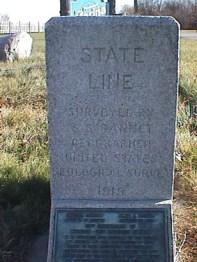
1 Ohio & Michigan Boundary Posts History, Recovery & Preservation As originally surveyed by Samuel Stinson Gannett and Crew between July and October 1915 Joseph D. Fenicle, PS Ohio & Michigan Professional Land Surveyor Angular By Nature, LLC Adrian, MI Office of the Fulton County Engineer Wauseon, OH 1915 Ohio-Michigan State Line Survey In 1787 when the Northwest Ordinance was drafted based on an inaccurate map drawn by geographer John Mitchell, the problems began. Ohio thought the language from the Ordinance drawing an East-West line from the southern tip of Lake Michigan included present day Toledo and the Mouth of the Maumee River. The Michigan Territory held the Ordinance Line and when surveyed Ohio found the problem and changed their constitution to read a line drawn directly from Lake Michigan s southern extremity to the most northerly cape of the Miami (Maumee)Bay. Commonly known as the Harris Line, William Harris surveyed the line based upon Ohio s Constitution. John Fulton, as ordered by the Michigan Territory, surveyed the Ordinance Line, or Fulton Line and officially created the Toledo Strip. After the bloodless Toledo War and sour feelings on both sides Ohio was granted the 400 square miles of the Toledo Strip and by order of President Andrew Jackson granted Michigan Statehood and was granted 9000 square miles of the Upper Peninsula. As originally surveyed by William Harris in 1817, retraced by The Ohio Boundary Commissioners Surveyors and again retraced by General Land Office Surveyor Andrew Porter the line was finally permanently retraced and monumented by Samuel Stinson Gannett and crew in The 48 th Legislature of Michigan approved Act 84 of the Public Acts of 1915 and the 81rst General Assembly of Ohio approved House Bill 701 to jointly finance the survey. The survey resulted in 72 granite monuments being set over miles between July 12 and October 26, The entire survey cost $7, or $ per mile and was known as one of the cheapest state line retracement surveys ever performed, yet one of the most accurate. The monuments came from the largest open face granite quarry in the world Mount Airy, North Carolina. The monuments were shipped to Toledo and the top 18 inches were dressed and cut by Lloyd Walker Brothers of Toledo. S.S. Gannett, Geographer of the United States Geological Survey was known as a state line boundary retracement specialist. Over his career he surveyed the state lines between New Hampshire/Vermont, Maryland/West Virginia, North Carolina/Tennessee, Texas/Oklahoma and Idaho/Washington. He was the cousin of Henry Gannett, Chief Geographer of the United States Geological Survey. The Ohio-Michigan Boundary settled one of the most deeply disputed state lines in the United States. The granite monuments still exist today and when checked with modern survey instrumentation one can only marvel at the accuracy used to run and establish this historic state line Ohio-Michigan State Line Survey In 1787 when the Northwest Ordinance was drafted based on an inaccurate map drawn by geographer John Mitchell, the problems began. Ohio thought the language from the Ordinance drawing an East-West line from the southern tip of Lake Michigan included present day Toledo and the Mouth of the Maumee River. The Michigan Territory held the Ordinance Line and when surveyed Ohio found the problem and changed their constitution to read a line drawn directly from Lake Michigan s southern extremity to the most northerly cape of the Miami (Maumee)Bay. Commonly known as the Harris Line, William Harris surveyed the line based upon Ohio s Constitution. John Fulton, as ordered by the Michigan Territory, surveyed the Ordinance Line, or Fulton Line and officially created the Toledo Strip. After the bloodless Toledo War and sour feelings on both sides Ohio was granted the 400 square miles of the Toledo Strip and by order of President Andrew Jackson granted Michigan Statehood and was granted 9000 square miles of the Upper Peninsula. As originally surveyed by William Harris in 1817, retraced by The Ohio Boundary Commissioners Surveyors and again retraced by General Land Office Surveyor Andrew Porter the line was finally permanently retraced and monumented by Samuel Stinson Gannett and crew in The 48 th Legislature of Michigan approved Act 84 of the Public Acts of 1915 and the 81rst General Assembly of Ohio approved House Bill 701 to jointly finance the survey. The survey resulted in 72 granite monuments being set over miles between July 12 and October 26, The entire survey cost $7, or $ per mile and was known as one of the cheapest state line retracement surveys ever performed, yet one of the most accurate. The monuments came from the largest open face granite quarry in the world Mount Airy, North Carolina. The monuments were shipped to Toledo and the top 18 inches were dressed and cut by Lloyd Walker Brothers of Toledo. S.S. Gannett, Geographer of the United States Geological Survey was known as a state line boundary retracement specialist. Over his career he surveyed the state lines between New Hampshire/Vermont, Maryland/West Virginia, North Carolina/Tennessee, Texas/Oklahoma and Idaho/Washington. He was the cousin of Henry Gannett, Chief Geographer of the United States Geological Survey. The Ohio-Michigan Boundary settled one of the most deeply disputed state lines in the United States. The granite monuments still exist today and when checked with modern survey instrumentation one can only marvel at the accuracy used to run and establish this historic state line. 1

2 1915 Ohio-Michigan State Line Survey In 1787 when the Northwest Ordinance was drafted based on an inaccurate map drawn by geographer John Mitchell, the problems began. Ohio thought the language from the Ordinance drawing an East-West line from the southern tip of Lake Michigan included present day Toledo and the Mouth of the Maumee River. The Michigan Territory held the Ordinance Line and when surveyed Ohio found the problem and changed their constitution to read a line drawn directly from Lake Michigan s southern extremity to the most northerly cape of the Miami (Maumee)Bay. Commonly known as the Harris Line, William Harris surveyed the line based upon Ohio s Constitution. John Fulton, as ordered by the Michigan Territory, surveyed the Ordinance Line, or Fulton Line and officially created the Toledo Strip. After the bloodless Toledo War and sour feelings on both sides Ohio was granted the 400 square miles of the Toledo Strip and by order of President Andrew Jackson granted Michigan Statehood and was granted 9000 square miles of the Upper Peninsula. As originally surveyed by William Harris in 1817, retraced by The Ohio Boundary Commissioners Surveyors and again retraced by General Land Office Surveyor Andrew Porter the line was finally permanently retraced and monumented by Samuel Stinson Gannett and crew in The 48 th Legislature of Michigan approved Act 84 of the Public Acts of 1915 and the 81rst General Assembly of Ohio approved House Bill 701 to jointly finance the survey. The survey resulted in 72 granite monuments being set over miles between July 12 and October 26, The entire survey cost $7, or $ per mile and was known as one of the cheapest state line retracement surveys ever performed, yet one of the most accurate. The monuments came from the largest open face granite quarry in the world Mount Airy, North Carolina. The monuments were shipped to Toledo and the top 18 inches were dressed and cut by Lloyd Walker Brothers of Toledo. S.S. Gannett, Geographer of the United States Geological Survey was known as a state line boundary retracement specialist. Over his career he surveyed the state lines between New Hampshire/Vermont, Maryland/West Virginia, North Carolina/Tennessee, Texas/Oklahoma and Idaho/Washington. He was the cousin of Henry Gannett, Chief Geographer of the United States Geological Survey. The Ohio-Michigan Boundary settled one of the most deeply disputed state lines in the United States. The granite monuments still exist today and when checked with modern survey instrumentation one can only marvel at the accuracy used to run and establish this historic state line Ohio-Michigan State Line Survey In 1787 when the Northwest Ordinance was drafted based on an inaccurate map drawn by geographer John Mitchell, the problems began. Ohio thought the language from the Ordinance drawing an East-West line from the southern tip of Lake Michigan included present day Toledo and the Mouth of the Maumee River. The Michigan Territory held the Ordinance Line and when surveyed Ohio found the problem and changed their constitution to read a line drawn directly from Lake Michigan s southern extremity to the most northerly cape of the Miami (Maumee)Bay. Commonly known as the Harris Line, William Harris surveyed the line based upon Ohio s Constitution. John Fulton, as ordered by the Michigan Territory, surveyed the Ordinance Line, or Fulton Line and officially created the Toledo Strip. After the bloodless Toledo War and sour feelings on both sides Ohio was granted the 400 square miles of the Toledo Strip and by order of President Andrew Jackson granted Michigan Statehood and was granted 9000 square miles of the Upper Peninsula. As originally surveyed by William Harris in 1817, retraced by The Ohio Boundary Commissioners Surveyors and again retraced by General Land Office Surveyor Andrew Porter the line was finally permanently retraced and monumented by Samuel Stinson Gannett and crew in The 48 th Legislature of Michigan approved Act 84 of the Public Acts of 1915 and the 81rst General Assembly of Ohio approved House Bill 701 to jointly finance the survey. The survey resulted in 72 granite monuments being set over miles between July 12 and October 26, The entire survey cost $7, or $ per mile and was known as one of the cheapest state line retracement surveys ever performed, yet one of the most accurate. The monuments came from the largest open face granite quarry in the world Mount Airy, North Carolina. The monuments were shipped to Toledo and the top 18 inches were dressed and cut by Lloyd Walker Brothers of Toledo. S.S. Gannett, Geographer of the United States Geological Survey was known as a state line boundary retracement specialist. Over his career he surveyed the state lines between New Hampshire/Vermont, Maryland/West Virginia, North Carolina/Tennessee, Texas/Oklahoma and Idaho/Washington. He was the cousin of Henry Gannett, Chief Geographer of the United States Geological Survey. The Ohio-Michigan Boundary settled one of the most deeply disputed state lines in the United States. The granite monuments still exist today and when checked with modern survey instrumentation one can only marvel at the accuracy used to run and establish this historic state line. 2

 Ohio-Michigan U.S. Land Office Andrew Porter Survey of the Harris Line USGS Horizontal Triangulation Survey Ohio-Michigan Samuel Stinson Gannett Survey of the Harris Line and Porter Line.")
3 Survey History of Fulton County Benjamin Hough, DS & Alexander Holmes, DS Michigan Meridian Survey Ohio-Michigan William Harris Survey Ohio-Michigan John A. Fulton Survey of the Ordinance Line General Land Office Surveys (Riley, Kellogg, Beasley, Heaton, Rice, Wampler, Mullett, Swan, et al) Andrew Talcott, Washington Hood & Robert E. Lee Survey of the Ordinance Line Ohio-Michigan Ohio Commissioners Survey (Sebried Dodge, Jonathan Taylor, Uri Seely & John Patterson) Ohio-Michigan U.S. Land Office Andrew Porter Survey of the Harris Line USGS Horizontal Triangulation Survey Ohio-Michigan Samuel Stinson Gannett Survey of the Harris Line and Porter Line. 1rst Order USGS Vertical Survey 1rst Order USCGS Horizontal Triangulation Survey 3rd Order USGS Vertical Survey 3rd Order USGS Vertical Survey 1rst Order NGS Horizontal Survey Dean Ringle, PS, PE Ohio-Michigan Survey of the Stinson Line 1rst Order Fulton County Engineers Office Horizontal Control GPS Survey 1rst Order Ohio Department of Transportation Horizontal Control GPS Survey ODOT CORS/VRS Survey GPS Low Distortion Projection Project (Village of Archbold) 3
4 = 1817 William Harris Survey June 18, Mile Post plus 59 Chains, 6 Links August 01, Mile Post August 12, 1817 August 06, 1817 = 1817 William Harris Survey = 1818 John Fulton Survey June 18, Mile Post plus 59 Chains, 6 Links August 01, Mile Post August 12, 1817 August 06, 1817 October 19,
5 = 1817 William Harris Survey = 1818 John Fulton Survey = 1834 Andrew Talcott Survey June 18, Mile Post plus 59 Chains, 6 Links August 01, Mile Post August 12, 1817 August 06, 1817 October 19, 1818 = 1817 William Harris Survey = 1818 John Fulton Survey = 1834 Andrew Talcott Survey = 1835 Ohio Commissioners Survey June 18, Mile Post plus 59 Chains, 6 Links August 01, Mile Post August 12, 1817 August 06, 1817 October 19, 1818 = 1817 William Harris Survey = 1818 John Fulton Survey = 1834 Andrew Talcott Survey = 1835 Ohio Commissioners Survey = 1837 Andrew Porter Survey June 18, Mile Post plus 59 Chains, 6 Links August 01, Mile Post August 12, 1817 August 06, 1817 October 19,
6 = 1817 William Harris Survey = 1818 John Fulton Survey = 1834 Andrew Talcott Survey = 1835 Ohio Commissioners Survey = 1837 Andrew Porter Survey = 1842 John Mullett Survey June 18, Mile Post 194 Mile Post plus 59 Chains, 6 Links August 01, 1817 August 12, 1817 August 06, 1817 October 19, 1818 = 1817 William Harris Survey = 1818 John Fulton Survey = 1834 Andrew Talcott Survey = 1835 Ohio Commissioners Survey = 1837 Andrew Porter Survey = 1842 John Mullett Survey = 1915 Samuel Gannett Survey June 18, Mile Post 194 Mile Post plus 59 Chains, 6 Links August 01, 1817 August 12, 1817 August 06, 1817 October 19, 1818 = 1817 William Harris Survey = 1818 John Fulton Survey = 1834 Andrew Talcott Survey = 1835 Ohio Commissioners Survey = 1837 Andrew Porter Survey = 1842 John Mullett Survey = 1915 Samuel Gannett Survey June 18, Mile Post 194 Mile Post plus 59 Chains, 6 Links August 01, 1817 August 12, 1817 August 06, 1817 October 19,
7 Barzillai Gannett Elizabeth Farley Barzillai Gannett Elizabeth Farley 2/9/2017 Details of the 1915 Survey Crew Samuel Stinson Gannett, Geographer U.S. Geological Survey, in charge. L.L. Linton, of Michigan, Recorder. C. Alfred Campbell, of Ohio, Rear Chainman. F.G. Sorenson, of Ohio, Rear Chainman. R.B. Jackson, of Michigan, Rear Rodman. R.B. Sherman, of Ohio, Head Rodman. Instruments Transit No. 80 (new) with circles 6 inches in diameter graduated to 10 spaces Telescope furnished with stadia wire, ratio 1 to 100 Two 300-foot steel tapes graduated to feet throughout. One 100-foot steel tape, with necessary repair outfit. Two red and white iron transit rods 8 feet in length. One stadia rod 13 feet in length. Plumb bobs, tally pins, etc. Sherman, Christopher. The Ohio-Michigan Boundary. Columbus: The Ohio State Reformatory, P. 15 & 25. Print. Edward Elizabeth Michael Farley Catherine Joseph Barzillai Joseph Farley Edward Elizabeth Michael Farley Catherine Joseph Barzillai Joseph Farley 7
8 Joseph Farley Gannett Mary E. Patterson Barzillai Gannett Elizabeth Farley Barzillai Gannett Elizabeth Farley Barzillai Gannett Elizabeth Farley Michael Farley Gannett Hanna Trufant Michael Farley Gannett Hanna Trufant Michael Farley Gannett Hanna Trufant 2/9/2017 Edward Elizabeth Michael Farley Catherine Joseph Barzillai Joseph Farley Seth Sarah Henry James Catherine Edward Elizabeth Michael Farley Catherine Joseph Barzillai Joseph Farley Henry Gannett Chief Geographer, United States Geological Survey Seth Sarah Henry James Catherine Edward Elizabeth Michael Farley Catherine Joseph Barzillai Joseph Farley Henry Gannett Chief Geographer, United States Geological Survey Charles Eben Mary George Sarah Isabel Addie Emma Joseph Miland Anna William Arthur Samuel Stinson Seth Sarah Henry James Catherine 8

9 Joseph Farley Gannett Mary E. Patterson Joseph Farley Gannett Mary E. Patterson Barzillai Gannett Elizabeth Farley Barzillai Gannett Elizabeth Farley Michael Farley Gannett Hanna Trufant Michael Farley Gannett Hanna Trufant 2/9/2017 Samuel Stinson Gannett Geographer, United States Geological Survey Edward Elizabeth Michael Farley Catherine Joseph Barzillai Joseph Farley Henry Gannett Chief Geographer, United States Geological Survey Charles Eben Mary George Sarah Isabel Addie Emma Joseph Miland Anna William Arthur Samuel Stinson Seth Sarah Henry James Catherine Samuel Stinson Gannett Geographer, United States Geological Survey Edward Elizabeth Michael Farley Catherine Joseph Barzillai Joseph Farley Henry Gannett Chief Geographer, United States Geological Survey Charles Eben Mary George Sarah Isabel Addie Emma Joseph Miland Anna William Arthur Samuel Stinson Seth Sarah Henry James Catherine (Married Samuel Gideon Stinson) 9
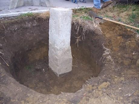
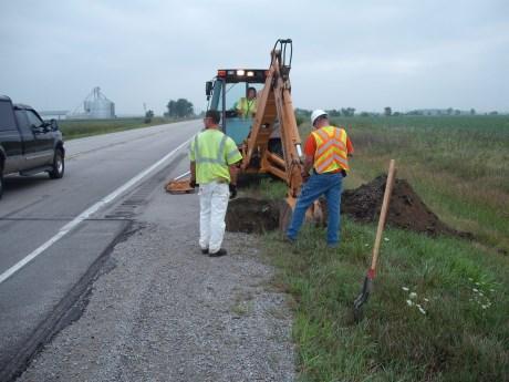
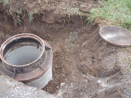
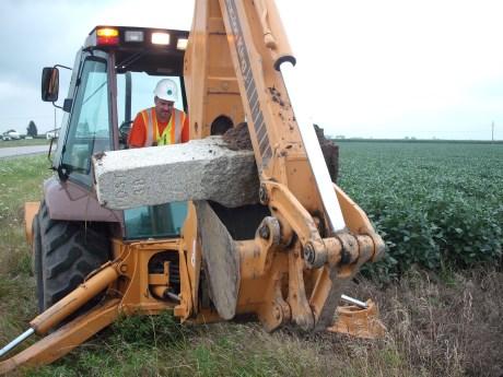
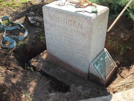
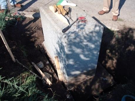
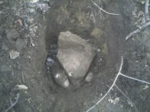
10 a society for the increase and diffusion of geographic knowledge January 13, 1888 a society for the increase and diffusion of geographic knowledge January 13, 1888 The Cosmos Club Washington D.C. Founded by John Wesley Powell also one of the founders History of Boundary Posts 72 Monuments Total Cost $18.00 each including delivery Total height = 5 6 Originated in Mount Airy, North Carolina Each post weighs 700 pounds and is surrounded by 700 pounds of concrete The top 18 was dressed by Lloyd Walker Brothers in Toledo, OH 10

11 Post 49 November 08,


12 12


13 13


14 Post 33 December 15,


15 15


16 16


17 17

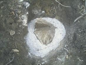
18 Post 38 April 27, 2007 & August 12, 2010 Considered Lost 18


19 19


20 20


21 21


22 22


23 23


24 24


25 25
26 Post 40 October 02,


27 27


28 28


29 29

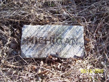
30 Post 22 March 16,


31 31


32 32

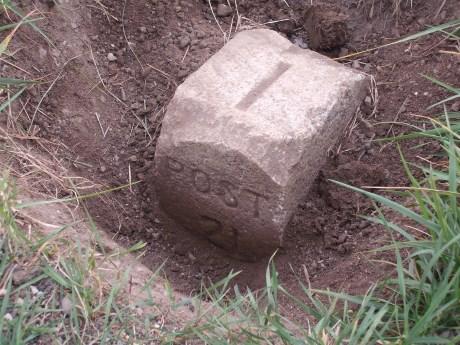
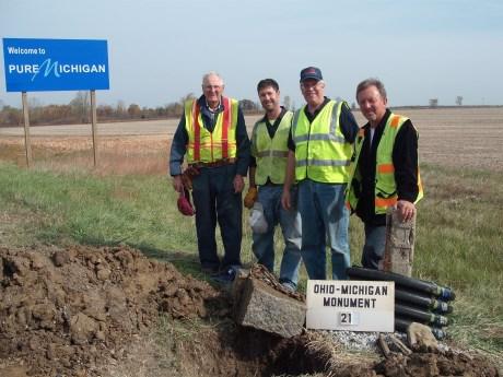
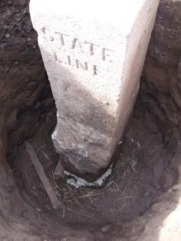
33 Post 21 August 18, 2010 & October 13, 2010 Considered Lost 33


34 34

35 35


36 36

37 Post 41 October 17,


38 Post 70 October 07,


39 39


40 40

41 41


42 42

43 Post 54a December 16, 2015 Ringle, Dean C. Ohio-Michigan Boundary Resurvey. Point of Beginning. February-March Print 43

44 Ringle, Dean C. Ohio-Michigan Boundary Resurvey. Point of Beginning. February-March Print Photos Courtesy of GrizzFlyer Ringle, Dean C. Ohio-Michigan Boundary Resurvey. Point of Beginning. February-March Print 44

45 45
46 46
47 Post 28 September 16,


48 48


49 49

50 Post 29 September 16,


51 51


52 52
53 53
54 54

55 Thank You Questions? 55
2/9/2017 FEBRUARY 23, Joseph D. Fenicle, PS Ohio & Michigan Professional Surveyor Angular By Nature, LLC Adrian, Michigan
 FEBRUARY 23, 2017 Radisson Plaza Hotel Kalamazoo, MI Joseph D. Fenicle, PS Ohio & Michigan Professional Surveyor Angular By Nature, LLC Adrian, MI http://rhymeswithorange.com/?s=the+new+neighbors Joseph
SURVEYING ECONOMICS. Thought Leader Our own worst enemy. Surveying History Following the footsteps. Decided Guidance Staying within your survey
 FEBRUARY 2017 SURVEYING ECONOMICS Thought Leader Our own worst enemy Surveying History Following the footsteps Decided Guidance Staying within your survey James Captain Riley The Sea, the Sahara, the Swamp
HONORING THE SURVEY OF THE MICHIGAN MERIDIAN
 HONORING THE SURVEY OF THE MICHIGAN MERIDIAN Submitted by Joseph Fenicle, PS On November 17, 1807 a line was described as the Western line of the Treaty of Detroit. This line would become the Michigan
History Kids LET US IN! Statehood FOR MICHIGAN MICHIGAN FOR SPRING 2001
 MICHIGAN History History Kids SPRING 2001 FOR LET US IN! Statehood FOR MICHIGAN What s INSIDE... Features: We Want In!...4 Toledo, Michigan?...9 How They Got Here...10 Coming to Michigan...12 Elsewhere
2008 SURVEY OF INDIANA COUNTY SURVEYORS
 THE COUNTY SURVEYOR: 2008 SURVEY OF INDIANA COUNTY SURVEYORS 1. Are you a Registered Land Surveyor or Professional Engineer? a. REGISTERED LS b. PE c. BOTH d. NEITHER 2. Is your position as County Surveyor
Zeroing in on Christopher Gist s cabin site
 Zeroing in on Christopher Gist s cabin site By Lannie Dietle Christopher Gist looms large in regional and national history for the important role he played in the years leading up to the French and Indian
Descendants of John Miller
 FIRST DRAFT OF 06/12/2003 Summary not to be relied upon as "primary documentation" SUMMARY OF ABSTRACT OF TITLE Utica Township, Clark Co., Indiana Tract 1 57 acres in Section 51 Tract 2-6.5 acres in Section
 Pleasant Hill Baptist Church Cemetery Inquire and please, ask permission to enter private property. Quadrant Map: Billingsville General Location: East northeast of Pilot Grove Congressional Township: Township
This Newsletter marks the tenth All About Stout newsletter! To celebrate, can you find all 10 Tens in this Newsletter edition? Inside this Issue:
 Volume 4, Issue 2 June 2014 www.stoutconnection.org Inside this Issue: 1 Moody Memorial - Richard Stout 1 Find the 10 tens! 2 Stout Committee Information 2 Family Search Sources 3 June 2014 - Stout Reunion
Chief Pontiac. The Life of Chief Pontiac: A Timeline. Three Important Facts About Chief Pontiac:
 Brook Trout Chief Pontiac The Life of Chief Pontiac: A Timeline 1750 1755 1760 1765 1770 Three Important Facts About Chief Pontiac: Detroit: Edmund Fitzgerald Questions What year did the ship sink? What
Brown Family History
 Brown Family History Hugh Carr Brown (1814-1902), his wife Matilda Innman Brown (1814-1860) and five children settled in Marshall County around 1846. They came from Nashville, Tennessee. Hugh was the son
THE LATE GREAT PUGET SOUND MERIDIAN. Washington State s Own Principal Meridian. by Denny DeMeyer
 THE LATE GREAT PUGET SOUND MERIDIAN. Washington State s Own Principal Meridian by Denny DeMeyer Pausing briefly in a clearing in the forest while ascending a ridge just south of Bellingham, the surveyors
"To speak the name of the dead is to make him live again"
 "To speak the name of the dead is to make him live again" Ancient Egypt civilization lasted over 3000 years. Egyptian monuments have been around so long that their monuments were ancient even in Greek
Born 1: November 01, 1746 in: Stafford County, Virginia Born 2: November 01, 1746 in: Overwharton Parrish, Stafford County, Virginia
 Husband: Charles Yelton Born 1: November 01, 1746 Born 2: November 01, 1746 in: Overwharton Parrish, Stafford County, Virginia Married: May 03, 1769 Died: July 02, 1817 in: Bourbon County, Kentucky Father:
CHAPTER 5 GENEALOGY OF THE FAMILY OF JOSEPHINE PORTER TAYLOR
 CHAPTER 5 GENEALOGY OF THE FAMILY OF JOSEPHINE PORTER TAYLOR Introduction - Origins of the Porter Family This genealogy outlines the ancestry of Josephine Porter, wife of Charles P. Taylor of Ottawa, Illinois
What is Dowsing? Who Can Dowse? How Can I Tell If I Am A Dowser? Which Device Shall I Start With?
 All about Dowsing! What is Dowsing? Remember when your grandfather "witched" for water with a forked stick? That is dowsing! The basic dowsing tools have evolved into L-rods, pendulums, Y-rods, bobbers
DECEMBER 2016 MT. SOLEDAD. GLO Surveying Short cut method. Decided Guidance Obeying our Oath. Train Surveying Rapid data
 DECEMBER 2016 MT. SOLEDAD GLO Surveying Short cut method Train Surveying Rapid data Decided Guidance Obeying our Oath The Short Cut Method» JERRY PENRY, PS n certain areas of the country, the surveyors
The New England Putnams Ohio to Tennessee to Mississippi
 UPDATED AUGUST 18, 2011 The New England Putnams Ohio to Tennessee to Mississippi In almost every southern state, there pops up a bunch of Putmans and Putnams that just don't seem to fit in with ours. In
CHESTER DISTRICT, SC EQUITY INDEX
 CHESTER DISTRICT, SC EQUITY INDEX This index lists only the names of the major parties. Equity Court files frequently, but not always, contain specific family information. Equity bills for partitions and
Living In Territorial Utah: culture, business, transportation, and mining. Timeline. Schools in Utah Territory
 Slide 1 Living In Territorial Utah: culture, business, transportation, and mining Chapter 8 Slide 2 Timeline 1850 The University of Deseret (U of U) opens. Utah s first newspaper, the Deseret News, is
Early Adventures at Put-in-Bay, Middle Bass and Johnson s Island Copyright 2008 by Michael Gora
 Early Adventures at Put-in-Bay, Middle Bass and Johnson s Island Copyright 2008 by Michael Gora Cover Note: The two images on the bottom of the cover show Put-in-Bay harbor around 1865. In the image on
The Knowledge Bank at The Ohio State University. Ohio Mining Journal. Front Matter
 The Knowledge Bank at The Ohio State University Ohio Mining Journal Title: Front Matter Issue Date: 1896 Citation: Ohio Mining Journal, no. 25 (1896). URI: http://hdl.handle.net/1811/32719 Appears in Collections:
A. A. (ALPHONSO ALBERT) COLE PAPERS,
 COLE PAPERS,") Collection # M 0586 OM 0263 A. A. (ALPHONSO ALBERT) COLE PAPERS, 1836-1862 Collection Information Biographical Sketch Scope and Content Note Box and Folder List Cataloging Information COLLECTION INFORMATION
Collection # M 0586 OM 0263 A. A. (ALPHONSO ALBERT) COLE PAPERS, 1836-1862 Collection Information Biographical Sketch Scope and Content Note Box and Folder List Cataloging Information COLLECTION INFORMATION
a. The Annexation Area is adjacent to and contiguous to the existing boundaries ofthe City of Jeffersontown; and,
 CITY OF JEFFERSONTOWN JEFFERSON COUNTY, KENTUCKY ORDINANCE NO. 1341, SERIES 2016 AN ORDINANCE ANNEXING TO THE CITY OF JEFFERSONTOWN A CERTAIN TRACT OF LAND IN THE COUNTY OF JEFFERSON, ADJOINING THE PRESENT
HISTORIC AMERICAN ENGINEERING RECORD WYMAN BRIDGE HAER NO. AR-38. UTM: 15/ / Quad: Elkins, Arkansas. Washington County, Arkansas
 HISTORIC AMERICAN ENGINEERING RECORD WYMAN BRIDGE LOCATION: Spanning the White River on Washington County Road 48 near Fayetteville, Washington County, Arkansas. UTM: 15/3992390/402650 Quad: Elkins, Arkansas
--Read American Baptist magazine promoting sanctification, credited it with that work in her life
 Chapter 5 --Mother Lizzie Woods Roberson (Robinson) --Born 1860 to slaves; education valued in the home; supported herself after both parents died --Married at 20, worked as a laundress --Read American
Why is the Treaty at Logstown in 1748 so important? What did it do?
 Student Worksheet A Shot in the Backwoods of Pennsylvania Sets the World Afire Worksheet 1: Focus Questions for "The Roots of Conflict" Instructions: Your group may answer these questions after the reading
Descendants of Henry Taylor Wiseman
 Descendants of Henry Taylor Wiseman By Nyla CREED DePauk Based on the 1850 and 1860 Monroe County, Virginia, Federal censuses, Henry Taylor Wiseman was born between June 28 and July 28, 1813, probably
Tennessee State Library and Archives
 Box 1 -- Folder 1 Tennessee State Library and Archives LETTERS OF THE TENNESSEE GOVERNORS JOHN SEVIER 1796-1801 ( Part 1 ) NAME YEAR PLACE INCOMING OUTGOING SUBJECT Smith, Daniel (Gen.) 1791 Philadelphia,
506 Tombstone Inscriptions, Gape May G. H., N. J.
 506 Tombstone Inscriptions, Gape May G. H., N. J. TOMBSTONE INSCRIPTIONS IN THE BAPTIST GRAVEYARD AT CAPE MAY COURT HOUSE, N. J. COPIED BY MBS. EMMA 8TEELMAN ADAMS. (Continued from page 364.) Hand, Aaron,
Tennessee State Library and Archives
 Box 1 -- Folder 5 Tennessee State Library and Archives LETTERS OF THE TENNESSEE GOVERNORS JOHN SEVIER 1796-1801 ( Part 2 ) NAME YEAR PLACE NA Adams, John (President of the US) Adams, John (President) Anderson,
Table of Contents. Our Pennsylvania Story 5
 Table of Contents United States Political Map...........................................2 Pennsylvania Political Map...........................................3 Pennsylvania Physical Map...........................................4
Genealogy of the Hand Family
 Genealogy of the Hand Family Nathan Hand (M) b. 13 November 1781, d. 18 September 1845 Nathan Hand was born on 13 November 1781 in Morris, NJ. He married Margaret Crandelmire on 15 July 1803 in Wantage,
Chapters 10 & 11 Utah Studies
 Chapters 10 & 11 Utah Studies Chapter 10-The Territory Prospers The Railroad Changes Utah Trains were important for moving raw materials from mines to manufacturing centers. They also carried raw material
WINSTON, NAT COLLECTION OF WINSTON FAMILY PAPERS
 State of Tennessee Department of State Tennessee State Library and Archives 403 Seventh Avenue North Nashville, Tennessee 37243-0312 WINSTON, NAT COLLECTION OF WINSTON FAMILY PAPERS 1825-1963 Processed
THE WELLINGTONS OF TRAPELO ROAD by Elizabeth Castner 1
 THE WELLINGTONS OF TRAPELO ROAD by Elizabeth Castner 1 Roger Wellington was in Watertown as early as 1636. He lived first in the eastern part of the town, his homestall being mostly in Mt. Auburn but was
Historic Marker Dedicated to Dr. Simon Green Atkins Saturday, June 11, 2005
 Historic Marker Dedicated to Dr. Simon Green Atkins Saturday, June 11, 2005 by Jane Pyle Historic marker dedicated to Simon Green Atkins on June 11, 2005. Text of marker is at right. Details below. SIMON
Aaron Linton Thompson
 Aaron Linton Thompson Commander - 1900 Born in Wayne County, Indiana, September 23, 1836, Aaron Linton Thompson remembered nothing of the wearisome journey to Arkansas. Brought up on the home farm, near
Chapter 3: Many Flags over Iowa
 Chapter 3: Many Flags over Iowa CONTENT OBJECTIVES IOWA PAST TO PRSENT TEACHERS GUIDE Revised 3 rd Edition Following the completion of the readings and activities for this chapter, students will have acquired
A Tourist s Guide To Heaven
 A Tourist s Guide To Heaven We often think of heaven as a vague notion someplace way out there where we might go someday. However, if we look at heaven from the point of view of the Christian faith, we
S T A T E O F M I C H I G A N BOARD OF COMMISSIONERS OF THE COUNTY OF ALLEGAN. May 26, 2016
 143-798 S T A T E O F M I C H I G A N BOARD OF COMMISSIONERS OF THE COUNTY OF ALLEGAN May 26, 2016 BOARD OF COMMISSIONERS APPROVE PARTIAL RELEASE PROTECTIVE COVENANTS WHEREAS, on May 2, 2016, the Allegan
November 16, 1889, The Tribune, p. 1, col. 3, Evansville, Wisconsin
 Miss Maggie Cornelius friends were considerable surprised to learn of a sudden attack of sickness, after being informed that she was about to leave Berckley Springs for home. Her return now is indefinitely
Bradley Rymph IN THE FOOTSTEPS OF OUR ANCESTORS
 IN THE FOOTSTEPS OF OUR ANCESTORS RESTLESS PIONEERS Samuel Wilson King (1827 1905) & Margaret Taylor Gerrard (1831 1892) / Albert James Rymph (1851 1926) & Luella Maria King (1861 1949) Bradley Rymph The
Keen Field Sr. ( ) Culpeper County Virginia, Jefferson County, Kentucky & Gibson County, Indiana Keen* Field Sr.
 Culpeper County Virginia, Jefferson County, Kentucky & Gibson County, Indiana Keen* Field Sr.") Keen Field Sr. (1744-1815) Culpeper County Virginia, Jefferson County, Kentucky & Gibson County, Indiana Sex: M AKA: Birth Date: Abt 1774 Place: Culpeper County, Virginia Chr. Date: Place: Death Date:
Keen Field Sr. (1744-1815) Culpeper County Virginia, Jefferson County, Kentucky & Gibson County, Indiana Sex: M AKA: Birth Date: Abt 1774 Place: Culpeper County, Virginia Chr. Date: Place: Death Date:
TURNER, Henry McNeal. Digital Howard University. Howard University. MSRC Staff
 Howard University Digital Howard @ Howard University Manuscript Division Finding Aids 10-1-2015 TURNER, Henry McNeal MSRC Staff Follow this and additional works at: http://dh.howard.edu/finaid_manu Recommended
Boone County Commission Minutes 1 December December Session of the December Adjourned Term. Boone County Government Center Commission Chambers
 TERM OF COMMISSION: PLACE OF MEETING: PRESENT WERE: December Session of the December Adjourned Term Boone County Government Center Commission Chambers Presiding Commissioner Don Stamper District I Commissioner
Abraham Lincoln. By: Walker Minix. Mrs. Bingham s 2 nd Grade
 Abraham Lincoln By: Walker Minix Mrs. Bingham s 2 nd Grade Table of Contents Chapter 1 Young Abe Page 1 Chapter 2 Rise To Greatness Page 2 Chapter 3 President Lincoln Page 3 Chapter 4 The Assassination
February 17, Senator Rob Portman 448 Russell Senate Office Building Washington, DC Dear Senator Portman,
 February 17, 2016 Senator Rob Portman 448 Russell Senate Office Building Washington, DC 20510 Dear Senator Portman, Last February, during Black History month, we celebrated the protection of the Pullman
1787 Tax List of Atkinson Hill, Nelson County, KY Pottingers & Beans (Banes) Cos; probably sw Nelson and Hardin Cos
 Cos; probably sw Nelson and Hardin Cos") Mathias Jayne, Kentucky Land Patent abstract 200 acres, Nolin Waters of Green River (Nolin River, which flows into Green River). Surveyed first for Philip Philips. Bounded by the east on Greenwalts land,
Mathias Jayne, Kentucky Land Patent abstract 200 acres, Nolin Waters of Green River (Nolin River, which flows into Green River). Surveyed first for Philip Philips. Bounded by the east on Greenwalts land,
March Loyal. Set up tables or areas for each den to display pictures and items made during this month s adventure, if applicable.
 March Loyal Title Our National Treasures A Scout Is Loyal. How Does Our National Treasures Relate to This Point of the Scout Law? A Scout is loyal. A Scout is true to his nation. America is blessed with
Land Owner or Occupier
 Land Owners and Occupiers Upper Hutt 1915 land owners recorded on the Military Manoeuvre Map [Scan and add image to document] Land Owner or Occupier ALEXANDER A (Aaron John) ALTON (John & Florence) BACKSTROM
Updated 3/20/18. The Rev. Christine Caton 8 Craig Rd Old Lyme, CT /
 Updated 3/20/18 To: Clerks of Session/Moderators in Vacant Pulpits From: Pam Garner, Office Administrator Re: Pulpit Supply January through June 2018 Date: January 2018 The following persons have expressed
Read Horizons Ch. 5, p and complete notes to answer the following questions
 Name/Date: Socials Studies 9 Unit 4 The Many Wests 4B Northwest Rebellion References: Horizons (text) Canada: A Peoples History (video) Useful Website: History of the Northwest Rebellion http://members.memlane.com/gromboug/p5nwreb.htm
Family Group Record. LDS Ordinance Data. Chr: in: End: Other Spouses: Pauline Jane BELL. LDS Ordinance Data. Chr: in: End: Other Spouses:
 Husband: Cary Allen VAN CLEAVE 23 Aug 1802 Chr: End: Married: 16 Dec 1823 Place: Washington County KY Seal: 14 May 1865 Place: Marion County, KY Burial: Father: Aaron VAN CLEAVE, jr Mother: Rachel BRENT
JOHN COFFEE PAPERS,
 JOHN COFFEE PAPERS, 1796-1887 Finding aid Call number: Extent: 2 cubic ft. (6 archives boxes.) To return to the ADAHCat catalog record, click here: http://adahcat.archives.alabama.gov:81/vwebv/holdingsinfo?bibid=3272
Mount Rushmore. Written by Kathy Furgang. Visit for thousands of books and materials.
 Mount Rushmore A Reading A Z Level N Leveled Reader Word Count: 566 LEVELED READER N Written by Kathy Furgang Visit www.readinga-z.com for thousands of books and materials. www.readinga-z.com Mount Rushmore
John Wesley Powell, : Famous Explorer of the American West
 17 March 2012 MP3 at voaspecialenglish.com John Wesley Powell, 1834-1902: Famous Explorer of the American West johnwesleypowell.com A replica of John Wesley Powell in the Emma Dean boat at the John Wesley
Parts one and two of the transcriptions of the documents within the Elena Gallegos Land Grant papers
 The Elena Gallegos Land Grant Part III by Henrietta M. Christmas and Angela Lewis Parts one and two of the transcriptions of the documents within the Elena Gallegos Land Grant papers can be found in the
Philadelphia County (Pa.)
") Philadelphia County (Pa.) Records 1671-1855 4 boxes, 3 volumes, 1 lin. feet Contact: 1300 Locust Street, Philadelphia, PA 19107 Phone: (215) 732-6200 FAX: (215) 732-2680 http://www.hsp.org Processed by:
Philadelphia County (Pa.) Records 1671-1855 4 boxes, 3 volumes, 1 lin. feet Contact: 1300 Locust Street, Philadelphia, PA 19107 Phone: (215) 732-6200 FAX: (215) 732-2680 http://www.hsp.org Processed by:
BLACK ROCK FOUNDRY RECORDS, Accession
 Finding Aid for BLACK ROCK FOUNDRY RECORDS, 1829-1839 Finding Aid Published: November 2011 20900 Oakwood Boulevard Dearborn, MI 48124-5029 USA research.center@thehenryford.org www.thehenryford.org OVERVIEW
Upper-Grade Presidential Spelling Boxes
 Upper-Grade Presidential Spelling Boxes 1. Spell the name of the president who founded the University of Virginia. This president built and lived in a house he named little mountain in Italian. Today it
For more information, see: Wiley Sword, Mountains Touched with Fire: Chattanooga Besieged, 1863 (St. Martin s Griffin, 1997) and Arthur M.
 and Arthur M.") MATHEWS AND KIN IN THE CONFEDERATE ARMY The Civil War claimed five sons of Josiah Allen and Lucy (Martin) Mathews. One died from illness, Marion. The four others returned: David, Elijah, Joe (Josiah),
MATHEWS AND KIN IN THE CONFEDERATE ARMY The Civil War claimed five sons of Josiah Allen and Lucy (Martin) Mathews. One died from illness, Marion. The four others returned: David, Elijah, Joe (Josiah),
MASTABAS PYRAMIDS. How did the Egyptian burial practices evolve?
 "To speak the name of the dead is to make him live again" Ancient Egypt civilization lasted over 3000 years. Egyptian monuments have been around so long that their monuments were ancient even in Greek
1 st Year Greenhand Preliminary Test 2001 (You have 25 minutes to complete test)
") 1 st Year Greenhand Preliminary Test 2001 (You have 25 minutes to complete test) 1. The first National FFA President was: A. Wade Turner, New Jersey B. Kenneth Pettibone, Oregon C. Leslie Applegate, New
1 st Year Greenhand Preliminary Test 2001 (You have 25 minutes to complete test) 1. The first National FFA President was: A. Wade Turner, New Jersey B. Kenneth Pettibone, Oregon C. Leslie Applegate, New
Motion was made by Mr. Robinson to approve the minutes as presented and carried as follows:
 A REGULAR MEETING OF THE BOARD OF SUPERVISORS OF THE COUNTY OF NEW KENT WAS HELD ON THE NINTH DAY OF APRIL IN THE YEAR OF OUR LORD NINETEEN HUNDRED NINETY IN THE BOARD ROOM OF THE COUNTY OFFICE BUILDING.
Thomas Wilkes - Descendant Chart Page 1
 Thomas Wilkes - Descendant Chart Page 1 1-Thomas Wilkes b. Abt 1735, d. Between 1808 and 1810 +Mary Conyers m. Abt 1762, Probably Halifax County, North Carolina, d. Between 1800 and 1810, par. Richard
NORTHWEST AND INDIANA TERRITORY DOCUMENTS,
 Collection # SC2972 NORTHWEST AND INDIANA TERRITORY DOCUMENTS, 1790-1819 Collection Information Historical Sketch Scope and Content Note Contents Cataloging Information Processed by Maire Gurevitz May
Washington Monument Written by Julia Hargrove
 Washington Monument Written by Julia Hargrove Illustrated by Gary Mohrman Teaching & Learning Company 1204 Buchanan St., P.O. Box 10 Carthage, IL 62321-0010 Table of Contents George Washington as a Child
BROWN, JOSEPH PAPERS,
 State of Tennessee Department of State Tennessee State Library and Archives 403 Seventh Avenue North Nashville, Tennessee 37243-0312 BROWN, JOSEPH PAPERS, 1772-1965 (THS Collection) Processed by: Gracia
Tarrant County. Civil War Veterans of Northeast Tarrant County. Edward Pompi Deason. Compiled by Michael Patterson
 Tarrant County TXGenWeb Barbara Knox and Rob Yoder, County Coordinators Copyright 2010-2012. All rights reserved. Civil War Veterans of Northeast Tarrant County Edward Pompi Deason Compiled by Michael
The Knowledge Bank at The Ohio State University. Ohio Mining Journal.
 The Knowledge Bank at The Ohio State University Ohio Mining Journal Title: Issue Date: Proceedings of the Ohio Institute of Mining Engineers: Summer Meeting 15-Aug-1885 Citation: Ohio Mining Journal, vol.
Deer Range Ranch Skutumpah Rd MM 500 Cannonville, UT
 NAI Utah South is pleased to offer the following exclusive listing: FOR SALE Skutumpah Rd MM 500 Cannonville, UT Click For More Info Click For More Info 640+/- Acre South Central Utah Cattle Ranch Sweeping
Albert Hollister - Son of a Pioneer
 Albert Hollister - Son of a Pioneer In 1837 two friends from New York State who had heard the call of the west took a boat from Buffalo to Kenosha. They were Edward Brigham Hollister and John Whiteman,
"Itty Bitty Mormon City"
 "Itty Bitty Mormon City" It s time to think small; really small. Your goal is to find the items pictured on the attached two pages. These items represent nearly unrecognizable bits and pieces of buildings,
Old Sandy Baptist Church Graveyard
 Old Sandy Baptist Church Graveyard By Dave Hallemann This original church cemetery is located in T41 R4 Survey 2018 in what was at one time called the Upper Sandy Settlement off Highway 21. It was visited
OGS FINDING AIDS OHIO GENEALOGICAL SOCIETY
 OHIO GENEALOGICAL SOCIETY 611 State Route 97 W Bellville OH 44813-8813 419-886-1903 www.ogs.org OGS FINDING AIDS Users of this collection should credit the Ohio Genealogical Society in any reference citing.
Boggs Cemetery. Clay, Arkansas. Photo by Leroy Blair. This Cemetery is also known as: None known. GPS Location:
 Boggs Cemetery Clay, Arkansas Photo by Leroy Blair This Cemetery is also known as: None known. GPS Location: 611593-3914937 Arkansas Archeological Survey site #: 3WH0731 Number of Marked Graves: About
Denny-Frye family papers,
 Overview of the Collection Creator Denny-Frye family Title Denny-Frye family papers Dates 1853-1915 (inclusive) 1853 1915 Quantity.28 cubic ft (113 items) Collection Number 0096 (Accession No. 0096-001)
HUNT FAMILY HISTORY. The Ancestors and Descendants of Major Samuel Hunt of Washington County, Tennessee
 HUNT FAMILY HISTORY The Ancestors and Descendants of Major Samuel Hunt of Washington County, Tennessee By Robert M. Wilbanks IV Scottsdale, Arizona 2004 (2004 revision of original compiled in 1988; reflecting
6 RITCHIEs & Caldwells
 6 RITCHIEs & Caldwells the RITCHIE family There appear to be several spellings of the surname Ritchie. In her book, The Richey Clan, Mary Durdin Bird uses the spelling Richey, but other documents and court
Charlottesville Sacred Spaces
 Charlottesville Sacred Spaces The sacred institutions chosen are not an all-encompassing list of historic worship spaces in town. These spaces were selected because of their proximity to the first recorded
THE SENEFF FAMILY. She was born February 5, 1772 in Bullskin, Fayette County, Pennsylvania.
 Updated May 2, 2017 THE SENEFF FAMILY The Seneff or Senff family is German. Virtually everything I have comes from Donna Senff Mata in California who is on the same basic line as we are. The first of the
Benedict Alford August 26, 1716 After 1790 By: Bob Alford 2010
 Benedict Alford August 26, 1716 After 1790 By: Bob Alford 2010 Benedict Alford was the oldest child of Benedict Alford and Abigail Wilson. He was born August 27, 1716 in Windsor, CT, according to Windsor
Relating to Electricity, 1885, Vol 33. makes more sense that they married in Utah Territory.
 Edward Randall Pike Edward Randall Pike was born 8 December 1857 in Brigg, Lincolnshire, England. He was the youngest of seven children of Peter Newman Pike and Mary Hendrie Randall. As a young boy, he
Middleburg Life, June Story and photos by Caitlin Scott
 Middleburg Life, June 2017 Story and photos by Caitlin Scott A car ride across the grounds of Oatlands Historic House and Gardens, a National Historic Landmark and a National Trust for Historic Preservation
Ramus/Macedonia (Illinois) Markers Dedicated
 Markers Dedicated") 143 Ramus/Macedonia (Illinois) Markers Dedicated William G. Hartley & Alexander L. Baugh In ceremonies on Saturday, 21 May 2000, more than fifty descendants of Ute and Sarah Gant Perkins, along with friends
143 Ramus/Macedonia (Illinois) Markers Dedicated William G. Hartley & Alexander L. Baugh In ceremonies on Saturday, 21 May 2000, more than fifty descendants of Ute and Sarah Gant Perkins, along with friends
RESOLUTION OPPOSING INCLUSION OF LAND LOCATED IN UTAH COUNTY IN THE MOUNTAIN ACCORD
 Resolution 2015- RESOLUTION OPPOSING INCLUSION OF LAND LOCATED IN UTAH COUNTY IN THE MOUNTAIN ACCORD WHEREAS, Mountain Accord, in its Program Charter, seeks to make integrated and critical decisions regarding
Boone County. and the Revolutionary War. By: Robin Edwards Local History Associate
 Boone County and the Revolutionary War By: Robin Edwards Local History Associate Typically the first places that come to mind when asked about the Revolutionary War are Lexington and Concord. After all,
Thomas Clark Jr. Pioneer of 1848, 1851 and compiled by Stephen Clark
 Thomas Clark Jr. Pioneer of 1848, 1851 and 1853 compiled by Stephen Clark 1848 FIRST TRIP TO OREGON: In the year of 1848, Thomas Clark Jr. immigrated to the Oregon Territory from Illinois. The only thing
TEACHING WITH ONLINE PRIMARY SOURCES: DOCUMENTS FROM THE NATIONAL ARCHIVES
 r TEACHING WITH ONLINE PRIMARY SOURCES: DOCUMENTS FROM THE NATIONAL ARCHIVES "TO LABOUR DILIGENTLY" SEARCHING FOR ECONOMIC INDEPENDENCE IN THE POST-CIVIL WAR SOUTH Michael Hussey National Archives and
City Council Agenda Item #10_ Meeting of June 27, Resolution approving the final plat of LEGACY OAKS 3 rd ADDITION
 City Council Agenda Item #10_ Meeting of June 27, 2016 Brief Description Resolution approving the final plat of LEGACY OAKS 3 rd ADDITION Recommendation Adopt the resolution approving the request Introduction
Family Search Marriage: About 1729 Virginia Internet Death: 20 February 1777/9 Albemarle Co., Virginia
 Sex: Family Group Husband s Full Name Nicholas Gentry II Sheet Date of: Day Month Year Town County State or Country Additional Info. Information Obtained From: Birth: 30 May 1697 New Kent, *b. 30 March
Hebden Bridge Baptist Heritage Trail
 Hebden Bridge Baptist Heritage Trail This Trail covers three periods of Baptist expansion in the 17 th and 18 th centuries: 1. The work of the Rossendale Confederacy of Particular Baptists (those believing
Chapter 11: Out of Turmoil, West Virginia Moves Closer to Statehood
 Chapter 11 Out of Turmoil, West Virginia Moves Closer to Statehood Chapter Preview Terms slave state, free state, states rights, Missouri Compromise, Underground Railroad, Compromise of 1850, popular sovereignty,
Repository. Access Number. Processed by. Date Completed. Creators. Extent. Dates. Conditions Governing Access
 The Sherman Family Papers Repository Dutchess County Historical Society 549 Main Street Poughkeepsie, NY 12601 (845) 471-1630 http://www.dutchesscountyhistoricalsociety.org/ dchistorical@verizon.net Access
Mount Rushmore LEVELED BOOK N. A Reading A Z Level N Leveled Book Word Count: 566.
 Mount Rushmore A Reading A Z Level N Leveled Book Word Count: 566 LEVELED BOOK N Mount Rushmore Written by Kathy Furgang Visit www.readinga-z.com for thousands of books and materials. www.readinga-z.com
BIBLE NUMBERS IN THE GREAT PYRAMID INTRODUCTION
 BIBLE NUMBERS IN THE GREAT PYRAMID INTRODUCTION PREFACE Do the measurements in the Great Pyramid (GP) tell a story that fits together with the story told by the numbers in the Bible? Yes! The arrangement
LINCOLN PUBLIC LIBRARY ARCHIVES/ SPECIAL COLLECTIONS
 LINCOLN PUBLIC LIBRARY Bedford Road, Lincoln, Massachusetts ARCHIVES/ SPECIAL COLLECTIONS Elizabeth Little Papers Processed by William F. Carroll, CA May 2008 TABLE OF CONTENTS Series Subseries Page Box
People in Bardstown, Kentucky, have
 By Joshua J. Perkey Church Magazines Inspired by the Lord, members of this small Kentucky branch have experienced great success in family history work. A Bountiful People in Bardstown, Kentucky, have a
Descendants of Patrick Gullion
 b. abt 0 Ireland d. 0 Lexington, Fayette Co., KY + Mary d. 0 Lexington, Fayette Co., KY b. bet and d. aft 0 + Margaret Stenson + (---) (---) Edmund Gullion b. bet and d. bef 0 b. bet and d. abt + (---)