CHAPTER III PROFILE OF THE STUDY AREA
|
|
|
- Dana Craig
- 5 years ago
- Views:
Transcription
1 CHAPTER III PROFILE OF THE STUDY AREA 3.1 General Knowledge about the socio-economic profile of the study area facilitates proper understanding of the region. The employment and income level of farmers depend on farming in any region which in turn depends upon the agro-climatic factors such as soil, topography, rainfall, irrigation and other socio-economic and institutional factors prevailing in that region. A brief description of the profile of the study area namely Kalkulam taluk in Kanyakumari District is presented in this chapter. 3.2 District Profile Kanyakumari is a town in the state of Tamil Nadu in India. It is also sometimes referred to as Cape Comorin. Located at the southernmost tip of the Indian Peninsula, it is the geographical end of the Indian mainland. The district in Tamil Nadu where the town is located is called Kanyakumari District. Kanyakumari District is the smallest district in the Southern most part of the State of Tamil Nadu.
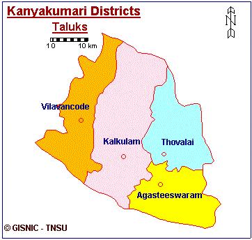
2 3.2.1 Kanyakumari District Kanyakumari district is named after the goddess KANYAKUMARI. It is the smallest district in Tamil Nadu. Even though it is the smallest in terms of area (1672sq.kms), the density of population is the highest in Tamil Nadu next to Chennai. In literacy it stands first. This small district is famous on its vast green stretches of paddy fields, banana fields, coconut groves, rubber gardens and luxurious forests, sea shore and the western Ghat. The area comprising of the present Kanniakumari district was a part of the erstwhile Travancore state before it merger with the state of Tamil Nadu. Kanyakumari District was formed on 1 st November 1956, with Nagercoil as its head quarter. It comprises of four taluks namely Agasteeswaram, Thovalai, Kalkulam and Vilavancode Location Kanyakumari is the southern most district of Tamil Nadu. The district lies between 77 o 15 ' and 77 o 36 ' of the eastern longitudes and 8 o 03 ' and 8 o 35 ' of the northern Latitudes. The District is bound by Tirunelveli District on the North and the east. The South Eastern boundary is the Gulf of Mannar. On the South and the South West, the boundaries are the Indian Ocean and the Arabian Sea. On the West and North West it is bound by Kerala. The district is bifurcated into two revenue Divisions namely, Padmanabhapuram and Nagercoil having the headquarters at Thuckalai and 77
3 Nagercoil respectively. There are four Taluks, Viz., Vilavancode, Kalkulam, Agasteeswaram and Thovalai. This district owns four Municipalities i.e, Nagercoil, Padmanabhapuram, Colachel and Kuzhithurai and nine development blocks. Six blocks namely Melpuram, Munchirai, Killiyoor, Thiruvattar, Thuckalay and Kuruthencode form a part of Padmanabhapuram Development Division and the remaining three Agasteeswaram, Rajakkamangalam and Thovalai come under Nagercoil Development Divisions. There are 56 town panchayats in this district whereas there are only 631 town panchayats throughout the State People and Culture The people are the human resource of the District. Their culture, religion, aptitude, habits, beliefs, talents etc have a bearing on how the district presents itself to others. Tamil and Malayalam are the main languages of this district. Hindus and Christians form a sizeable percentage of the population of the district and there are a number of Muslim dominated belts in the district. Rice is the staple food of the rich and the poor alike in the district. Some among the poorer section also use tapioca. Beverages like tea and coffee are widely spread even in the rural area of the district. 78
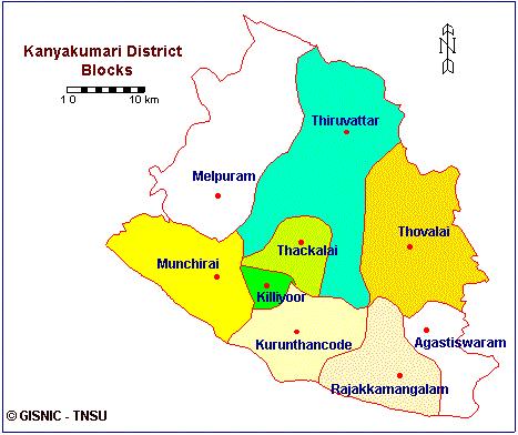
4 Thiruvattar Kurunthancode Thuckalay 3.1 Study Area 79
5 3.2.5 Area and Population The following table explains the area, population, literates, SC/ST and sexwise of the blocks and municipalities in Kanyakumari district. Table: 3.1 AREA, POPULATION, LITERATES IN BLOCKS AND MUNICIPALITIES Sl. No Name of the Blocks/ Municipalities Area (sq.km) Population Literate Persons Male Female Persons Male Female 1. Agastheswaram Rajakkamangalam Thovalai Kurunthancode Thuckalay Thiruvattar Killiyoor Munchiri Melpuram Nagercoil Municipality Padmanabapuram Colachel Kuzhithurai Total Source: Census of India
6 3.2.6 Education Kanyakumari District is one of the 100 per cent literate districts of India. The total number of educational institutions is 925. The various statistics regarding educational institutions in Kanyakumari District are listed in Table 3.2. TABLE: 3.2 EDUATIONAL INSTITUTIONS OF KANYAKUMARI DISTRICT Sl. No. Schools and Colleges No. of Institutions 1. Arts & Science College B.Ed., Colleges Medical colleges i) Allopathu ii) Indian Medicine iii) Homeopathy Engineering Colleges College for Special Education Pre-Primary Schools Primary Schools Middle Schools High Schools Higher Secondary Schools Teacher Training Institutes Total 925 Source: Assistant Director of Statistics, District Profile, District Statistical Office, Nagercoil,
7 Classification of Workers Classification of the Industrial and Agricultural Workers Total main workers of the district are 4,54,378 and marginal workers are 93,678. Total workers constitute cultivators, agricultural labourers, households, industrial workers and other workers per cent are cultivators and per cent are agricultural labourers. Table 3.3 shows industrial and agricultural the classification of workers. TABLE: 3.3 CLASSIFICATION OF THE INDUSTRIAL AND AGRICULTURAL WORKERS (Year ) District Tamil Nadu Sl. Industrial Category % to % to No. Persons Total Workers Persons Total Workers 1. Total Main Workers 4,54, ,37,57, Marginal Workers 93, ,20, Total Workers 5,48, ,78,78, a. Cultivators 13, ,16, b. Agricultural Labourers 56, ,37, Household Industry, Manufacturing Processing, Servicing and Repair 23, ,99, c. Other Works 3,60, ,26,24, Total Non-workers 11,27,978-3,45,27,397 - Total Population 16,76,034-6,24,05,679 - Source: Census of India,
8 3.2.8 Scheduled Castes and Tribes Out of the total population of Kanyakumari District 4.60 per cent are Scheduled Castes and 0.31 per cent are Scheduled Tribes. Table 3.4 gives a detailed listing of the population of Scheduled Castes and Scheduled Tribes in the various blocks and municipalities of Kanyakumari District. Sl. No TABLE: 3.4 SCHEDULED CASTES AND SCHEDULE TRIBES IN KANYAKUMARI DISTRICT Name of the Blocks/ Schedule Caste Schedule Tribes Municipalities Persons Male Female Persons Male Female 1. Agastheswaram Rajakkamangalam Thovalai Kurunthancode Thuckalay Thiruvattar Killiyoor Munchiri Melpuram Nagercoil Municipality Padmanabapuram Colachel Kuzhithurai Total Source: Census of India
9 3.2.9 Health and Medicine Kanyakumari District is blessed with good medical and health facilities, with a number of hospitals, Health Care Institutions, Primary Health Centres and other such institutions. Table 3.5 gives all the relevant information. TABLE: 3.5 STATISTICS ON HEALTH AND MEDICINE IN KANYAKUMARI DISTRICT (in number) Sl. No. Particulars Modern Medicine Indian Medicine Homeopathy 1. Hospitals including T.B. Hospital Dispensaries Primary Health Centers Health Sub-Centers Other Medical Institutions Beds in Hospitals and Dispensaries Total Number of Doctors Total number of Nurses Medial College Source: Assistant Director of Statistics, District Profile, District Statistical Office, Nagercoil,
10 3.2.8 Soil Condition Soil in the district is mostly of red loam variety. In the seacoast sandy type of soil prevails and near the mountain regions gravel soil is generally seen. In the low lands there is neither white sand nor sandy loam. The mid lands and high lands contain fairly fertile soil. The valleys in the mid land have loamy clay soil with high sand content. Generally in the mid lands the soil is clay loam of laterite origin with an admixture of gravel sand. The soil fertility is given in terms of the content of nitrogen, phosphorous and potash. The soil in most of the blocks has low content of nitrogen, phosphorous and potash, while the soil in Killiyoor and Agesteeswaram blocks contains medium content of potash. The ph value of the soil generally ranges from 4.5 to 8.0. Different categories of soil and the suitability of crops are shown in the Table
11 TABLE: 3.6 TYPES OF SOIL AND SUITABILITY OF CROPS IN KANYAKUMARI DISTRICT Sl. No. Soil Type Crops Grown Irrigated 1. Type Tropopsamments Lithic Ustrothents Lithic Troporthents Paralithic Troporthents Typic Troporthents Typic Ustropepts Typic Eutropepts Typic Dystropepts Fluventic Dystropepts Udic Haplustalfs Udic Rhodustalfs Udic Hapludalfs Typic Tropudalfs Aquie Tropudalfs Aquire Hapludalfs Typic Udipsamments - Banana Banana Cole crops Flower and Cole crops Cole crops Paddy - Paddy Cole crops Paddy Paddy Paddy Paddy - Rainfed Coconut Orchard crops Rubber Rubber Orchard crops Tapioca Rubber Tapioca Coconut Pulses Cashew Pulses Pulses - - Coconut Source: Soil Atlas of Kanyakumari District, Soil Testing Laboratory, Nagercoil, Climate and Rainfall The District has a favourable agro-climatic condition, which is suitable for growing a number of crops. The proximity of equator, its topography and other climate factors favour the growth of various crops. The paddy varieties grown in the second crop season in Thovalai and Agasteeswaram taluks are grown during 86
12 the first crop season in Kalkulam and Vilavancode taluks. This shows that there is distinct variation in the climatic conditions prevailing within the district. Unlike other district in Tamil Nadu, it has a rainfall both during the South West and the North East monsoons. The South West monsoon period starts from the month of June and ends in September, while the North East monsoon period starts from October and ends in the middle of December. The temperature details are given in Table 3.7. TABLE: 3.7 DETAILS OF TEMPERATURE IN KANYAKUMARI DSITRICT (in 0 Celsius) Month January 2009 February March April May June July August September October November December Maximum Temperature Minimum Temperature Normal Actual Normal Actual Average Source: Soil Atlas of Kanyakumari District, Soil Testing Laboratory, Nagercoil,
13 A systematic recording of rainfall in Kanyakumari district was started as early as Now there are 37 stations to record the rainfall. Out of these 37 stations, 32 are functioning while five are not. The details are given in Table 3.8. TABLE: 3.8 TALUK WISE DENSITY OF RAINGUAGE STATIONS IN KANYAKUMARI DISTRICT District / Taluk Kanyakumari Agasteeswaram Thovalai Kalkulam Vilavancode Area in sq.km No. of Rainguage Stations Density in sq. km Source: Live Register, Assistant Director of Statistics, District Statistical Office, Nagercoil, In the hill region the rainfall is uniformly distributed through the monsoons and the maximum rainfall is seen during the months of October and November. The coastal regions receive the maximum rainfall during the northeast monsoon followed by the southwest monsoon periods. On the whole, Kanyakumari District has an overall rainfall of mm Cropping Pattern This district produces paddy, tapioca and oilseeds such as groundnut and coconut besides commercial crops like cashew, rubber, fruits and spices. The important feature of this district is the production of off season mangoes. 88
14 Paddy is the main crop of this district. It is grown in two seasons. First crop is sown in the month of April-June (Kannipoo) and second crop is raised in the month of September-October (Kumba poo). Tapioca is raised as a subsidiary food crop in this district. The main planting season is April-May. In some pockets, September-October planting is also done as second season crop. It is purely raised as rainfed crop in Kalkulam and Vilvancode taluks and as irrigated crop in some area of Agastheeswaram taluk of this district. Coconut is an important cash crop of this district. The main planting season is May to July. Pulses are raised in rice-fallow and as intercrop in Tapioca. The important pulses are blackgram, greengram, horsegram, cowpea and redgram. In the months of April-May and September-October pulses are grown as intercrop with Tapioca. In the months of February- March pulses are raised as pure crop in rice-fallows. Vegetables are cultivated during January-February and July-August. Vegetable is also grown as 3rd crop after the harvest of 2nd crop paddy in some pockets of this district. Banana is cultivated mainly during March-May and September-October. Groundnut is raised during March-April and October-November as rainfed crop in small extent. In addition, pepper, cloves, arecanut, betelvine, cocoa, gingelly, ginger, turmeric, arrowroot etc. are also grown in this district. 89
15 The existing physical and technical factors have permitted to grow a variety of crops in the study area. The cultivable crops can be broadly classified into the following heads as given in Table 3.9. TABLE: 3.9 CROPPING PATTERN Sl. No. Crops Cultivated Area in HA % to the Cross Cropped Area Paddy Pulses Spices and Condiments Sugar Crops Banana Other Fruits and Vegetables Coconut Other Food Oil Crops Non-food Oil Crops Medicinal Crops Manure Crops Flowers Grove Verities Rubber Other Verities 18, , , , , , Total 88, Source: G Return, District Statistical Office. Nagercoil, The gross cropped area during in Kanyakumari District is 88, hectares. Of the gross cropped area per cent is used for the 90
16 cultivation of paddy, for coconut, per cent for rubber and per cent for banana and other fruits and vegetables is cultivated in an area of 6.73 per cent. Thus it is revealed that next to paddy banana cultivation occupies an important place in the study area Irrigation Systems The ancient irrigation works in this district dates back well over thousand years. The Pandian dam across the river Paraliyar and the feeding channel known as Pandiankal were constructed by the ancient rulers about one thousand years ago. Irrigation may be defined as the supply of water by human efforts for the cultivation of crops. The function of irrigation is to supplement the supplies of water obtained in the form of rain on the area to be cultivated during the season and to extend required water for the successful cultivation of crops. Irrigation projects may be in the form of surface flow, or ground water. Surface flow irrigation covers rivers, canals, tanks, springs and others. The ground water is confined to the exploitation of under ground water through wells. This is given in Table 3.9. The surface irrigation is the major source in the district. Nearly per cent of the total irrigated area is covered by the surface flow irrigation sources and the remaining 2.10 per cent by ground water irrigation sources. 91
17 TABLE 3.10 AREA IRRIGATED BY DIFFERENT SOURCES IN KANYAKUMARI DISTRICT Sl. No. Name of the Source Gross Area Irrigated in HA A Surface Flow Irrigation B 1. Canals 2. Tanks Sub-Total Ground Water Irrigation 1. Tube Wells 2. Dug Wells 3. Others Sub-Total 13, , , Percentage Total Area Irrigated 36, Source: G Return, District Statistical Office. Nagercoil, The second irrigation commission classified the irrigation projects into three categories on the basis of their cultivable command area, or the total area irrigated by the projects. They are major irrigation projects, medium irrigation projects and minor irrigation projects. This is shown in Table
18 TABLE: 3.11 MAJOR IRRIGATION PROJECTS Sl. No. Name of the Project Estimated Cultivable Command Area in HA A. Major Irrigation Projects Kodayar Project Chittar-Pattanamkal Project B. Medium Irrigation Projects Neyyar Irrigation Project C. Minor Irrigation Project Arruvikkarai Weir System Thirpparappu Weir System Vilathur Lift Irrigation Project Major and Minor Irrigation Tanks Different Forms of Well Other sources 25,900 12,950 3, , Source: Season and Crop Report of Tamil Nadu (Various Issues) Agriculture Agriculture is the main occupation of the people of Kanyakumari District. Total number of cultivators is 16,067 and the agricultural labourers are 81,999. Total area cultivated in is 94,374 hectares and the net area sown is 79, hectares. Area sown more than once is 9, hectares. The land use pattern in Kanyakumari District is given in Table
19 Sl. No TABLE: 3.12 LAND USE PATTERN IN KANYAKUMARI DISTRICT ( ) Forests Particulars Barren and Uncultivable Land Land out to non-agricultural Uses Cultivable Waste Permanent Pastures Land and Miscellaneous Trees and Groves Fallow Land Net sown Area Area sown more than Once Kurunth ancode (Area in Hectares) Thuckalay Thiruvattar District Total Source: Assistant Director of Statistics, District Profile, District Statistical Office, Nagercoil, Area under forests represents both government and private lands covered by forests. In Kanyakumari District hectares of the total area are occupied forests. The barren and uncultivable land comprises the land under mountains and deserts. Such lands are not fit for cultivation purposes. There are 4, hectares of the total land has been identified as barren and uncultivable in the study area. Land not used for agricultural uses covers the lands used for buildings, roads, railways, the area covered by water and other similar purposes and this accounts for 28, hectares. Cultivable land that remains as waste refers to 94
20 the land which is available for cultivation but not cultivated during the current year or the previous five years or more. Only hectares of land accounts for this cultivable waste. Fallow land consists of fallow lands that are not currently cultivated and other fallow lands. Current fallows are the cultivable lands which are kept fallow after the harvest. This accounts for hectares. Net area sown is the area cropped at least in an agricultural year. In the study area, this accounts for 79, hectares to the total geographical area in the year Thus the highest priority has been given to the net area sown in this district Roadways The network of roadways of a country is as essential as the arterial system to the human body. The roads in a big way facilitate advancement in the economy of a country and they simultaneously facilitate communication. In the matter of surface transport, they are almost equal to the railways which connect other parts of the country through its large railway network system. These two transports are not parallel but inter-dependent. The Chennai-Kanyakumari Highway joins the Kanyakumari-Trivandrum road near Aralvoimozhi which passes through Nagercoil touching other important places and terminates at Trivandrum in Kerala State covering a distance of 62.4 km. from Aralvoimozhi to Kerala border. The views on either side of this road can never fail to attract the travelers. 95
21 Coastal Environment The coastal environment is an interface between land and marine water. This ecosystem is valuable to humans from the dawn of civilisation. Human, biological and social needs are readily met by coastal zone. It has been estimated that by 2000 A.D., 75 per cent of the population of the world will be living in the coastal zone. This is also true in other developing maritime countries. Coastal ecosystem is under threat due to anthropogenic activities, increased human settlement, industrial pollution, etc Kanyakumari District and Its Coast Kanyakumari, the smallest District in Tamil Nadu, with a land spread of 1,684 sq. Km. has almost all ecosystem-forests, wetlands, freshwater resources, marine etc. Agricultural resources like plantation crops (Spices, rubber), banana, coconut, paddy, etc. are also produced. Among all this, coastal environment is very important with respect to fish production and fisher folk's employment. The coastal ecosystem of this District comprises 68 Km in length and is studded with 44 coastal fishing villages. Since this District is situated at the extreme south of the Indian subcontinent, the coastline is formed nearly by three seas, namely, Arabian Sea, Indian Ocean and Bay of Bengal. But the main part of the coast faces the Arabian Sea. 96
22 Forest The forest in Kanyakumari District is verdant and virgin Forests are said to be of 75 million years old. Of the total district area of hectares. Government Forests occupy an area of Hectares which comes to about 30.2 % the total District geographic area. The forests of Kanyakumari District was transferred from Kerala to Tamil Nadu on 1 st November 1956 as a result of the State re-organization. The Forests of this Divisions ie. Boothapandy Mahendragiri R.F. etc. were previously managed by the District Forest Officer, Tirunelveli South Division with Head quarters at Tirunelveli. Consequent on the formation of Kalakad and Mundathurari sanctuary, Kanyakumari Division was formed exclusively to manage the forests of Kanyakumari District with Head quarters at Nagercoil from as per G.O.Ms.No. 261 dated There are 14 types of forests from luxuriant tropical wet evergreen to tropical thorn forests occur in this District because of diverse locality factors, (according to Champion and Seths classification) Rainfall varies from 103 cm to 310 cm elevation from sea level to 1829 m. The forest area is 30.2 per cent of total district geographical area which is next to Nilgiris district with 59 per cent and Dharmapuri District with 38 per cent in the State. The District is having 52 per cent of its forests as dense forests coming only second to Dharmapuri District with 58 per cent. 97
23 The forests consist of soaring and lofty trees of Mesua ferrea, Bischofia Javanica, Vitex altissima to smaller trees of Dillini a species festooning climber, shrubs valuable herbs, variety of orchids, two types canes many indigenous palms and cycas. The important timbers are Teak, Rosewood, Vengai and Aini and this District is worth mentioning here for the easy availability and quality of the above timbers. Various types of forest produces like bamboos, reeds, canes soft wood, tamarind, lemon grass, rubber, coconut, Arecanut, Kadukai, Cinna momum bark, Nelli, Cardamom, Mango and many medicinal plants of High value are harvested in this District. The Maruthuvalmalai located among green paddy fields and fluttering coconut palms is famous for valuable medicinal plants. This is the only District in Tamil Nadu, where rubber and clove plantations have been raised in Reserve Forests in an area of hectares and 110 hectares respectively. The District is rich in wildlife with at least 25 types of mammals, about 60 species of birds including 14 species of migratory birds and many species of fishes, reptiles and amphibians listed. In short, these forests are a veritable trove of biological diversion. From Tourism angle, the Forests are highly enhancing with pleasant sholas hill top forests, beautiful grass lands, panoramic valleys, top hillocks, singing streams, vast stretches of rubber plantations valuable teak plantations and excellent climate. No body should miss seeing Mahendragiri, Maramalai, Sea field and Balamore estate area, Ecology farm, Kalikesam, Pechiparai Dam, Perunchani Dam, Upper Kodayar, Maruthamparai and Mukkudal areas for their 98
24 scenic beauty. All areas in forests are worth seeing in Kanyakumari District only. Various types of forests in Kanyakumari District are given in Table TABLE: 3.13 VARIOUS TYPES OF FORESTS IN KANYAKUMARI DISTRICT Sl. No Types of Forests Southern hill top tropical evergreen forest West vast semi evergreen forest Southern moist and teak forest Southern moist mixed deciduous forest Southern dry mixed deciduous forest Dry savannah forest Southern thorn forest Erratic umbrella thorn forest Southern sub-tropical hill forest Ochlandra reed brakes Source: Soil Atlas of Kanyakumari Dsitrict, Soil Testing Laboratory, Nagercoil, Kalkulam Taluk The Kalkulam taluk covers three blocks namely, Kurunthancode, Thiruvattar and Thuckalay. All the blocks are directly linked with every nook and corner of the district by means of a very good net work of roads. 99
25 3.3.1 Kurunthancode Block A short description of Kurunthancode block is presented in this subdivision. The Kurunthancode block is situated in the south-west of the Kanyakumari District. This block is surrounded in the West and the North by the Munchirai block. Killiyoor block, Thuckalay block and Tiruvattar block, the East by Rajakkamangalam block and the South by the Kerala state. This block consists of 15 revenue villages. This block has a total area of sq. kilometers. As per the 2001 census, the population of this block was 1,65,070 out of which the male population was 81,823 and the female population 83,247. The number of SC/ST was 5,723, which was 3.47 percent of the total population. The number of females per 1000 males is The climate is pleasant from September to December. During summer that is April to June it is hot. There are 20 primary schools, eight middle schools, eight high schools, five higher secondary schools, two matriculation higher secondary schools, two colleges and one ITI. This block has a coir making, ice manufacturing and mineral water processing industries which all come under small-scale industries. Occupational pattern shows that the total number of cultivators is 11,157. Agricultural labourers (15,905) constitute percent of the total work force. There are 7,759 male agricultural workers and 8,146 female ones. The total 100
26 numbers of workers in cottage and household industries are 1,287, which contribute only 3.54 percent of the total work force in the block. There are 391 male and 896 female workers in this category. Workers in other industries are 1,147. The numbers of male and female workers are 105 and 1,042 respectively. They form 3.16 percent of the total work force. Other workers are 6,048 or percent of the total work force. The main crops cultivated in the block are paddy, banana, tapioca, rubber, coconut, vegetables and fruits. Kurunthancode block has few infrastructure facilities and the cultivators mainly rely on the channel. The net area sown in this block is 3,851 hectares. Current fallow and other fallow lands account for 2,761 hectares. The area under barren and uncultivated land is 549 hectares. In this block all the 15 villages, 150 hamlets and four towns are electrified. There are 1,686 tube lights and 29 sodium vapours in the streets Thuckalay Block Thuckalay block is located on the North East of Thiruvattar and surrounded by Kurunthancode block, Killiyoor block and Munchirai block. There are sixteen revenue villages, seventeen village panchayats and a town panchayats in this block. This block has a total area of sq. kilometers. As per the 2001 census, the population of this block was 1,67,262 out of which the male population was 82,488 and the female population 84,774. The total number of literates is 1,31,428 out of which, 66,461 are male and 64,967 female. 101
27 The total number of work force in the block is 22,287 persons out of which 14,764 are male workers and 7,523 female workers. The percentage of workforce of the total population is There are no medium or large-scale industries in this block. Occupational pattern shows that the total number of cultivators is 3,108. Agricultural labourers (5,085) constitute only percent of the total work force. There are 4,184 male agricultural workers and 901 female agricultural workers. The total number of workers in the household industries manufacturing factory is 8,675 which contribute percent of the total work force in the block. There are 5,905 male and 2,770 female workers in this category. Marginal workers are 2,824. The numbers of male and female workers are 138 and 2,686 respectively. They form percent of the total work force. Other workers are 2,595 or percent of the total work force. The main crops cultivated in the block are paddy, coconut, banana, tapioca and rubber. In Thuckalay block, the cultivators mainly rely on tanks and canals. The net area sown in this block is 4,022 hectares. Current fallow and other fallow lands account for 3,566 hectares. The area of barren and uncultivated land is 284 hectares. The forest land occupies 5,080 hectares Thiruvattar Block A short description of Thiruvattar block is presented in this subdivision. Thiruvattar block is located almost on the northern side of the district. On the 102
28 northern side, the Kerala state is situated. Thovalai block lies on the eastern side. Munchirai, Thackalay and Kurunthancode blocks are the southern boundary of this block. To its southern side, Melpuram block is situated. There are 31 village panchayats in this block. With regard to education, there are eight pre-primary schools, 17 primary schools, 14 middle schools, five high schools, eight higher secondary schools, an Engineering college, a Teachers Training College, a polytechnic and an Art and Industrial School. This block has a total area of Sq. kilometers. As per the 2001 census, the population of this block was 1,61,619 out of which the male population was 80,220 and the female population 81,399. The number of females per 1000 males is 910. The main crops cultivated in the block are paddy, banana, tapioca, coconut and rubber. The Thiruvattar block has few infrastructure facilities and the cultivators mainly rely on the channel. The net area sown in this block is 7,761 hectares. Current fallow and other fallow lands account for 3,843 hectares. The area under barren and uncultivated land is 100 hectares. The forest land occupies 88 hectares. 3.4 An Overview Kanyakumari District is an agrarian society with a high density of population and 100 per cent literacy rate. Some of the notable features of this 103
29 district are the high mountain ranges, perennial river barins and picturesque sea coast. It is seen that the climate, soil, temperature, rainfall and moisture content prevailing here are suitable for the cultivation of banana. Thus this detailed analysis on the area profile of Kanyakumari District and Kalkulam Taluk proves that it has had a greater positive effect on the continuous growth of banana cultivation for quite a long period of time and the same is expected for the future also. 104
CHAPTER - IV PROFILE OF THE STUDY AREA
 CHAPTER - IV PROFILE OF THE STUDY AREA Origin and History of Kanyakumari District Kanyakumari district has its ancient history dating back to the Sangam Age a Cradle of Civilization in this part of India.
BANKING PROFILE OF KANYAKUMARI DISTRICT
 CHAPTER - II BANKING PROFILE OF KANYAKUMARI DISTRICT 2.1 INTRODUCTION Kanyakumari is a district of Tamil Nadu state and is the southernmost land area of the main land sprawled over an area of 1672 sq.km,
IMPORTANT DAMS IN KANYAKUMARI DISTRICT
 Chapter IV IMPORTANT DAMS IN KANYAKUMARI DISTRICT There are many dams both small and big in Kanyakumari district. The agricultural operations and the drinking water needs of the people of this district
CHAPTER - V. Status of Industries in Jalgaon District
 CHAPTER - V Status of Industries in Jalgaon District 5.1 Introduction 5.2 General Distribution of Industries 5.3 Types of Industries and Their Spatial Distribution 5.4 Location pattern of Industries 5.5
Shared on QualifyGate.com
 SAIL Exam General Awareness 1. Which of the following is not a rabi crop? (a) Wheat (b) Barley (c) Jute (d) Rapeseed 2. Blue Revolution is associated with (a) Fish (b) Milk (c) flower (d) Litmus 3. Study
The South Travancore, the present Kanyakumari District consists of. the four southern most taluks namely Agasthiswaram, Thovalai, Kalkulam
 INTRODUCTION Formatted: Font: Belwe Bd BT, Not Bold The South Travancore, the present Kanyakumari District consists of the four southern most taluks namely Agasthiswaram, Thovalai, Kalkulam and Vilavancode.
MYANMAR REGIONAL INFORMATION
 MYANMAR REGIONAL INFORMATION General Info Combining breath-taking natural beauty with a rich and glorious heritage that has maintained its identity over two thousand years of human history, Myanmar has
Khirbet Zanuta Profile
 Khirbet Zanuta Profile Prepared by The Applied Research Institute - Jerusalem Funded by Spanish Cooperation Azahar program 2009 0 Acknowledgments ARIJ hereby expresses its deep gratitude to the Spanish
DEVELOPMENT BRIEF SOUTH WAZIRISTAN AGENCY ( )
") DEVELOPMENT BRIEF OF SOUTH WAZIRISTAN AGENCY (2008-2009) 1 HISTORICAL AND ADMINISTRATIVE PROFILE OF SOUTH WAZIRISTAN AGENCY BACKGROUND The South Waziristan Agency was declared an Agency in 1895. South
DEVELOPMENT BRIEF OF SOUTH WAZIRISTAN AGENCY (2008-2009) 1 HISTORICAL AND ADMINISTRATIVE PROFILE OF SOUTH WAZIRISTAN AGENCY BACKGROUND The South Waziristan Agency was declared an Agency in 1895. South
By: Amanbir Kaur Wazir and her family
 By: Amanbir Kaur Wazir and her family I spent the: -summer with my family in India when I was 2 years old -winter months when I was 5 -and again when I was 9 years old. My family and our large Sikh circle
Chapter 24 Physical Geography of South Asia The land Where Continents Collided
 Chapter 24 Physical Geography of South Asia The land Where Continents Collided Section 1 Landforms and Resources Mt. Everest (29,035 ft.) is part of the Himalayan Mountains that form the border of the
South Asia Notes. Unit 10-3wks Test
 South Asia Notes Unit 10-3wks Test Indian Subcontinent India, Pakistan, Bangladesh, Bhutan, Nepal, Sri Lanka, the Maldives called Indian Subcontinent because India dominates the region Though half the
IAS Prelims Exam: Ancient History NCERT Questions: The Geographical Background of Indian History III
 IAS Prelims Exam: Ancient History NCERT Questions: The Geographical Background of Indian History III Old edition of NCERT Books are still high in demand in terms of UPSC IAS Exam Preparation because it
Khirbet Al Malih profile
 Khirbet Al Malih profile Produced by The Applied Research Institute - Jerusalem In cooperation with Funded by February, 2006 This document has been produced with the financial assistance of the European
The Giryama of Kenya. People and Language Detail Report
 People and Language Detail Report Profile Year: 1987 Language Name: Giryama ISO Language Code: nyf Primary Religion: Tribal Religion The Giryama of Kenya The Giryama, also called Giriama or Agiryama are
CHAPTER III MARINE FISHERIES BACKGROUND OF KANYAKUMARI DISRICT
 54 CHAPTER III MARINE FISHERIES BACKGROUND OF KANYAKUMARI DISRICT This part of the study aims to bring out a brief account of the salient features of marine fishery industry in Kanyakumari District. The
DISTRICT AND SESSIONS COURT, S O L A P U R
 DISTRICT AND SESSIONS COURT, S O L A P U R JUDICIAL HISTORY Between 1819 and 1824, for purpose of Civil and Criminal Justice, Sholapur was under Poona. In 1825 a first or Senior Assistant Judge was appointed
TAMIL NADU & PONDICHERRY COASTAL AREA ASSESSMENT
 TAMIL NADU & PONDICHERRY COASTAL AREA ASSESSMENT A POST TSUNAMI STUDY ON COASTAL CONSERVATION AND REGULATION EQUATIONS INDIA TAMIL NADU & PONDICHERRY Citation Core Research Team Extended Consultative Team
CHAPTER II A PROFILE OF THE STUDY REGION
 CHAPTER II A PROFILE OF THE STUDY REGION 2.1. Introduction The present study is carried out in the North Karnataka Region (NKR) one of the two major regions of the State of Karnataka the other being the
A study on the changing population structure in Nagaland
 A study on the changing population structure in Nagaland Y. Temjenzulu Jamir* Department of Economics, Nagaland University, Lumami. Pin-798627, Nagaland, India ABSTRACT This paper reviews the changing
Which is true about the Ganges River?
 ROUND 1 Which is true about the Ganges River? 1. The river is ignored by Indian religious rituals. 2. People do not drink the water because it is so polluted. 3. Many people use the river for transportation
Lesson 3 The Northern Plains
 Q1. Long Answers Lesson 3 The Northern Plains Q1.Why are the Northern Plains Fertile? A1. Many rivers originating in the Himalayas mountains flow through the Northern Plains. The rivers flowing through
The Bolon of Burkina Faso
 People and Language Detail Report Profile Year: 1996 Language Name: Bolon ISO Language Code: bof Primary Religion: Animism The Bolon of The Bolon live in western in a land of savannah, small forests, and
District Rural Development Agency, Kishanganj. - : MGNREGA :- Best Practices in Kishanganj District (BIHAR) Its all about PHASE - II
 Its all about PHASE - II") District Rural Development Agency, Kishanganj - : MGNREGA :- Best Practices in Kishanganj District (BIHAR) Its all about PHASE - II Kishanganj District At A Glance Area of the district: 1883.02 (square
District Rural Development Agency, Kishanganj - : MGNREGA :- Best Practices in Kishanganj District (BIHAR) Its all about PHASE - II Kishanganj District At A Glance Area of the district: 1883.02 (square
Deserts. the Empty Quarter is the largest sand desert in the world.
 Saudi Arabia GEOGRAPHIC FEATURES Saudi Arabia Part of the Arabian Peninsula Saudi Arabia is one fourth the size of the United States Deserts cover much of the east and south There are mountain ranges in
Chapter 16: The Eastern Mediterranean. Unit 7
 Chapter 16: The Eastern Mediterranean Unit 7 Section 1: Physical Geography Landforms This region includes the following countries: Syria Jordan Lebanon Israel Palestinian territories The Eastern Mediterranean
YEAR 7- Social Studies Term 1 plan
 Week Topic YEAR 7- Social Studies Term 1 plan 2016-2017 Learning outcomes 1 Introduction Students are given an overview of year 7 Social Studies and learning outcomes. Classroom expectations are made clear
The Ble of Burkina Faso
 People and Language Detail Report Profile Year: 1994 Language Name: Jalkunan ISO Language Code: bxl The Ble of The Ble live in southwestern in a village west of Banfora and south of Sindou. They are surrounded
Chapter II: Environmental Setting
 Section 1. Regional Profiles Chapter II: Environmental Setting The Oneida Lake watershed is situated within the Oswego-Seneca-Oneida Rivers Drainage Basin that drains to Lake Ontario, through the Gulf
Section 1 Natural Environments
 Section 1 Natural Environments India- Key physical features & River systems: Landforms- Subcontinent- Large land mass smaller than a continent Gangetic Plain alluvial plain Deccan peninsular plateau, bordered
A Socio-economic Profile of Ireland s Fishing Harbours. Greencastle
 A Socio-economic Profile of Ireland s Fishing Harbours Greencastle A report commissioned by BIM Trutz Haase* and Feline Engling May 2013 *Trutz-Hasse Social & Economic Consultants www.trutzhasse.eu +353
Trends of Urbanization in Nanded District of Maharashtra State
 EUROPEAN ACADEMIC RESEARCH Vol. II, Issue 2/ May 2014 ISSN 2286-4822 www.euacademic.org Impact Factor: 3.1 (UIF) DRJI Value: 5.9 (B+) Trends of Urbanization in Nanded District of Maharashtra State PRAMOD
PATTERN OF SUGARCANE CONCENTRATION IN SATARA DISTRICT OF MAHARASHTRA (INDIA)
") ISSN: 0976-8920 & E-ISSN: 0976-8939, Vol. 2, Issue 2, 2011, PP-45-50 Available online at http://www.bioinfo.in/contents.php?id=65 PATTERN OF SUGARCANE CONCENTRATION IN SATARA DISTRICT OF MAHARASHTRA (INDIA)
ISSN: 0976-8920 & E-ISSN: 0976-8939, Vol. 2, Issue 2, 2011, PP-45-50 Available online at http://www.bioinfo.in/contents.php?id=65 PATTERN OF SUGARCANE CONCENTRATION IN SATARA DISTRICT OF MAHARASHTRA (INDIA)
The Namo of Papua New Guinea
 People and Language Detail Report Profile Year: 2003 Language Name: Namo ISO Language Code: mxw The Namo speakers of Mari village live on the southern coast of Papua New Guinea in Western Province, close
South India. Overnight at Hotel Supreme or similar.
 South India The Peninsular India is an unlimited experience of rich and vibrant culture and lush topography. The area that dates historically to some of the oldest tribal settlements in the world today
The Hausa of Nigeria
 The Hausa of Nigeria The country of Nigeria, located on the western coast of Africa, has a total population of over 100 million people; 20.6 million of which are the Hausa. They are the largest ethnic
Presented at. Seminar and Site Visits August, Marc Tormo. Coffee Ideas!
 Presented at Seminar and Site Visits 26-28 August, 2010 Holistic Food Systems Marc Tormo Coffee Ideas! Holistic Food Systems Marc Tormo Auroville Green Practices Seminar 2010 1 of 20 Humanity Holistic
Spatial analysis of sex ratio according to different religions in Jalgaon district (MS)
") 217; 3(7): 124-1245 ISS Print: 2394-75 ISS Online: 2394-5869 Impact Factor: 5.2 IJAR 217; 3(7): 124-1245 www.allresearchjournal.com Received: 23-5-217 Accepted: 24-6-217 Badgujar Arvind Amrut Assistant
217; 3(7): 124-1245 ISS Print: 2394-75 ISS Online: 2394-5869 Impact Factor: 5.2 IJAR 217; 3(7): 124-1245 www.allresearchjournal.com Received: 23-5-217 Accepted: 24-6-217 Badgujar Arvind Amrut Assistant
Source of the rivers, scams of the rulers
 Source of the rivers, scams of the rulers Why rivers run dry while money floods the system in Maharashtra. P Sainath Vol. 51, Issue No. 26-27, 25 Jun, 2016 P Sainath (psainath@ruralindiaonline.org ) is
Discussion Topic: Delhi Sultanate and Mali Table Leaders: Brandon Butterwick Shrey Amin Neel Ambardekar Allie Arasi Andrew Buck
 Discussion Topic: Delhi Sultanate and Mali Table Leaders: Brandon Butterwick Shrey Amin Neel Ambardekar Allie Arasi Andrew Buck Questions prepared to Lead or Prompt discussion for the Harkness Discussion.
Market Update. Micro Irrigation
 Market Update Micro Irrigation Micro Irrigation Penetration Rate India China 5.5% 10.0% Brazil U.S. 52.0% 55.0% Spain 65.0% Russia 78.0% Israel 90.0% 0% 10% 20% 30% 40% 50% 60% 70% 80% 90% 100% Penetration
Maungakiekie-Tāmaki Local Board Profile. - Initial results from the 2013 Census. February 2014
 Maungakiekie-Tāmaki Local Board Profile - Initial results from the 2013 Census February 2014 Social and Economic Research Team Research, Investigations and Monitoring Unit Auckland Council Map of Maungakiekie-Tāmaki
The Journey of Ibn Battuta
 The Journey of Ibn Battuta THE JOURNEY Type of account (primary/ secondary, letter, diary, etc.) Home region/country of the traveler Purpose of the journey/dates Success/failure of the journey as related
Church Based Development Project Proposal
 Church Based Development Project Proposal Chipako Community, Zambia Project Background Bright Hope has been working in partnership with Samfya Community of Care Providers (SCCP) in the town of Samfya,
The Kapin of Papua New Guinea
 People and Language Detail Report Profile Year: 2004 Language Name: Kapin ISO Language Code: tbx The Kapin of Papua New Guinea The Kapin people live in Morobe Province of Papua New Guinea, along the Middle
CHAPTER III KANYAKUMARI A TOURIST DESTINATION
 CHAPTER III KANYAKUMARI A TOURIST DESTINATION 3.1 INTRODUCTION Kanyakumari district is the smallest district in Tamil Nadu. Even though it is the smallest in terms of area (1672 sq.km) its density of population
C H A P T E R IV KANYAKUMARI DISTRICT AND ITS PALMYRAH TAPPING INDUSTRY A PROFILE. Tamil Nadu, as it is well known, is famous for its palmyrah
 C H A P T E R IV KANYAKUMARI DISTRICT AND ITS PALMYRAH TAPPING INDUSTRY A PROFILE Tamil Nadu, as it is well known, is famous for its palmyrah tapping industry. Among all the districts in Tamil Nadu, the
SAMPLE PAPER SUMMATIVE ASSESMENT II CLASS VI. Time Allowed: 3 hrs. SOCIAL SCIENCE Maximum Marks: 100
 SAMPLE PAPER SUMMATIVE ASSESMENT II CLASS VI Time Allowed: 3 hrs. SOCIAL SCIENCE Maximum Marks: 100 General Instructions : 1. Answer all the questions. 2. Do not write anything in the question paper. 3.
The Bowiri of Ghana. People and Language Detail Report
 People and Language Detail Report Profile Year: 1996 Language Name: Tuwuli ISO Language Code: bov The Bowiri of The Bowiri people live in the Volta Region in the eastern part of. Their main subsistence
unjustified. Similarly 66 percent women felt that the practice of triple talaq was incorrect and unjustified.
 Appendix 2 Salient Points Highlighted by Dr. Sanjay Kumar, (Fellow, Centre for Study of Developing Societies), in his Paper titled Social and Economic Status and Popular Perception of Muslims in India,
The Diodio of Papua New Guinea
 People and Language Detail Report Profile Year: 2004 Language Name: Diodio ISO Language Code: ddi Primary Religion: Christian The Molata, Giwau, and Miyalabi (the people who speak Diodio) are located in
INDIAN SCHOOL MUSCAT MIDDLE SECTION SECOND SUMMATIVE ASSESSMENT
 INDIAN SCHOOL MUSCAT MIDDLE SECTION SECOND SUMMATIVE ASSESSMENT-2016-17 STD: VI Time: 2 Hours Date: 05.03.2017 SOCIAL SCIENCE Max. Marks: 60 GENERAL INSTRUCTIONS: All the questions must be answered on
TURKEY, SYRIA, LEBANON, JORDAN
 TURKEY, SYRIA, LEBANON, JORDAN TURKEY Turkey is a little larger than Texas. It bridges two continents: Europe and Asia The Asian part of Turkey is called Asia Minor. Three rivers separate the European
Lesson 1: Geography of South Asia
 Lesson 1 Summary Lesson 1: Geography of South Asia Use with pages 122 127. Vocabulary subcontinent a large region separated by water from other land areas monsoon season the rainy season subsistence farming
CHARACTERISTICS THAT CAN DESCRIBE A SANGHA AS "GOOD"
 MYRADA Rural Management Systems Series Paper - 15 2, Service Road Domlur Layout BANGALORE 560 071. INDIA. Fax E-mail Website : : : : 5353166, 5354457, 5352028, 5358279 091-80 - 5350982 myrada@blr.vsnl.net.in
Registration of Geographical Indications- Indian experience
 Registration of Geographical Indications- Indian experience Dr. C.R. Elsy Professor and Co-ordinator Centre for IP protection Kerala Agricultural University 1 Indian legislation India A member of WTO Signatory
Present. 1 India Past and. India and several other countries Pakistan, Bangladesh (BAHNG
 Guide to Reading Main Idea India is trying to develop its resources to meet the needs of its rapidly growing population. Terms to Know subcontinent monsoon green revolution jute cottage industry pesticide
The Burunge of Tanzania
 People and Language Detail Report Profile Year: 1996 Language Name: Burunge ISO Language Code: bds The Burunge of Tanzania The Burunge have a language that is of 'Cushitic' origin and has different structure
Geography and Culture
 Geography and Culture Southern Asia, bordering the Arabian Sea, between India on the east and Iran and Afghanistan on the west and China in the north Flat Indus plain in east; mountains in north and northwest;
EMPOWERMENT OF WOMEN IN THE INFORMAL SECTOR IN KERALA: A STUDY WITH SPECIAL REFERENCE TO KUDUMBASHREE PROJECT
 2 EMPOWERMENT OF WOMEN IN THE INFORMAL SECTOR IN KERALA: A STUDY WITH SPECIAL REFERENCE TO KUDUMBASHREE PROJECT INTRODUCTION Man is incomplete without a woman; she is nucleus of the family and forms half
A STUDY OF THE ADMINISTRATION OF SRI ANDAL TEMPLE IN SRIVILLIPUTHUR
 A STUDY OF THE ADMINISTRATION OF SRI ANDAL TEMPLE IN SRIVILLIPUTHUR Synopsis of the thesis submitted to Madurai Kamaraj University for the award of the Degree of DOCTOR OF PHILOSOPHY IN POLITICAL SCIENCE
Indian Ocean Trade and Social & Cultural Change AN AGE OF ACCELERATING CONNECTIONS ( )
") Indian Ocean Trade and Social & Cultural Change AN AGE OF ACCELERATING CONNECTIONS (600 1450) After 1200 there was an expansion of trade in the Indian Ocean, why? Rising prosperity of Asia, European, &
Indian Ocean Trade and Social & Cultural Change AN AGE OF ACCELERATING CONNECTIONS (600 1450) After 1200 there was an expansion of trade in the Indian Ocean, why? Rising prosperity of Asia, European, &
MONTHLY SYLLABUS SESSION CLASS-IV SUBJECT : SOCIAL STUDIES TERM-I (APRIL-SEPTEMBER) Lesson 1: India An Introduction
 Lesson 1: India An Introduction") MONTHLY SYLLABUS SESSION-2017-18 CLASS-IV SUBJECT : SOCIAL STUDIES MONTH CONTENT TERM-I (APRIL-SEPTEMBER) April 2017 Lesson 1: India An Introduction Introduction of our country India. Map of world to be
MONTHLY SYLLABUS SESSION-2017-18 CLASS-IV SUBJECT : SOCIAL STUDIES MONTH CONTENT TERM-I (APRIL-SEPTEMBER) April 2017 Lesson 1: India An Introduction Introduction of our country India. Map of world to be
Bringing the Gospel to the unreached, unengaged people groups in the Isaan Region, Thailand.
 Frontida Outreach Thailand Kanthararom, Sisaket Province Building bridges for our Lord and Saviour, Jesus Christ frontidaoutreach@gmail.com Bringing the Gospel to the unreached, unengaged people groups
International Seminar on Farmer Suicides in India
 PONDICHERRY UNIVERSITY SCHOOL OF SOCIAL SCIENCES & INTERNATIONAL STUDIES DEPARTMENT OF SOCIOLOGY International Seminar on Farmer Suicides in India Sponsored by Indian Council of Social Science Research,
Early Civilizations Review
 Early Civilizations Review An area with common physical features is called a. region The study of the ways of past cultures through the items they left behind is. archaeology The practice of worshipping
The Yaleba of Papua New Guinea
 People and Language Detail Profile Profile Year: Language Name: ISO Language Code: 2008 Yaleba ylb The Yaleba of Papua New Guinea The Yaleba people of Papua New Guinea live on the peninsula south of Alotau
SUMMATIVE ASSESSMENT - II,
 SUMMATIVE ASSESSMENT - II, 2015-2016 CLASS-VI Time Allowed: 3 hrs. SOCIAL SCIENCE Maximum Marks: 100 General Instructions : 1. Answer all the questions. 2. Do not write anything in the question paper.
SABAH THE STATE OF CHAPTER 13
 WALK THE LAND IN MALAYSIA 1 CHAPTER 13 THE STATE OF SABAH The location of Sabah has caused it to be called The Land Below the Wind or The County Below the Wind. It is situated to the south of the Philippines,
The Countries of Southwest Asia. Chapter 23
 The Countries of Southwest Asia Chapter 23 The Countries of Southwest Asia (Middle East) Creation of Israel After WWII, Jews had no where to go. In 1948, The United Nations decided to split Palestine between
The Middle East Today: Political Map
 The Middle East Today: Political Map 19 13 2 18 12 17 11--> 8--> 9 5 7 16 6
The Tauade of Papua New Guinea
 People and Language Detail Report Profile Year: 2004 Language Name: Tauade ISO Language Code: ttd The Tauade of Papua New Guinea The Tauade language group is located approximately 45 minutes by air from
Chapter 13. Tropical Africa and Asia, AP World History
 Chapter 13 Tropical Africa and Asia, 1200-1500 AP World History I. Tropical Lands and Peoples A. The Tropical Environment Tropical zone between the Tropic of Cancer and Tropic of Capricorn. Equator in
The Sacred Waters of a Tanker
 The Sacred Waters of a Tanker Maharashtra s water crisis continues even if media coverage of it dries up with the onset of the rains P SAINATH Vol. 51, Issue No. 26-27, 25 Jun, 2016 P Sainath (psainath@ruralindiaonline.org)
The Aruamu of Papua New Guinea
 People and Language Detail Report Profile Year: 2003 Language Name: Aruamu ISO Language Code: msy The Aruamu of Papua New Guinea Primary Religion: Christian, Animism Disciples (Matt 28.19): 20% Churches:
IMPACT OF URBANIZATION ON CULTURAL LANDSCAPE: A CASE STUDY OF LUCKNOW METROPOLIS, INDIA
 IMPACT OF URBANIZATION ON CULTURAL LANDSCAPE: A CASE STUDY OF LUCKNOW METROPOLIS, INDIA Presented By: Dr. Sarika Shukla & Anamika Shukla I.T.P.G. College, Lucknow & Symbiosis Law School, Noida E-mail Id-
LEVEL OF URBANISATION AND THEIR DISPARITIES IN MAHARASHTRA STATE
 Scholarly Research Journal for Interdisciplinary Studies, Online ISSN 2278-888, SJIF 216 = 6.17, www.srjis.com UGC Approved Sr. No.45269, JULY-AUG 217, VOL- 4/35 LEVEL OF URBANISATION AND THEIR DISPARITIES
The Tiéfo of Burkina Faso
 Profile Year: 2015 People and Language Detail Profile Language Name: Tiéfo ISO Language Code: tiq Primary Religion: Ethnic Religion & Islam Disciples (Matt 28:19): Unknown Churches: 6 Elderly Tiéfo Woman,
EARLY IRRIGATION SYSTEMS IN KANYAKUMARI DISTRICT
 Chapter I EARLY IRRIGATION SYSTEMS IN KANYAKUMARI DISTRICT The irrigation system of Kanyakumari District dates back to pre-sangam period. The Ay kings who ruled between 4 th century B.C. and 9 th century
SAINT ANSELM S SOUTHALL
 SAINT ANSELM S SOUTHALL JULY 2016 1 PROFILE AND MISSION OF THE PARISH Southall enjoys a diversity of communities from many faiths and ethnic groups and has attracted migrants since the beginning of the
Era 1 and Era 2 Test. 1. Which geographic feature was most important to the development of the early river valley civilizations?
 1. Which geographic feature was most important to the development of the early river valley civilizations? A. fertile soils B. high mountains C. vast deserts D. smooth coastlines 2. The study of culture
The Global Religious Landscape
 The Global Religious Landscape A Report on the Size and Distribution of the World s Major Religious Groups as of 2010 ANALYSIS December 18, 2012 Executive Summary Navigate this page: Geographic Distribution
The Geographic and Political Situation at the Time of Christ s Ministry
 3 The Geographic and Political Situation at the Time of Christ s Ministry Whenever some students see the word geography, they cringe, thinking that the subject is boring and impractical. In reality, geography
The War-Jaintia of Bangladesh
 Profile Year: 2004 People and Language Report Language Name: War-Jaintia ISO Language Code: aml The War-Jaintia of Bangladesh The War-Jaintia belong to the wider Khasi ethnic group, but speak War-Jaintia.
The Basoga of Uganda
 Profile Year: 2006 People and Language Detail Profile Language Name: Lusoga ISO Language Code: xog Primary Religion: Christian/Traditional Disciples (Matt 28:19): 25% Churches: Unknown Scripture Status
The Roviana of Solomon Islands
 Profile Year: 2014 People and Language Detail Profile Language Name: Roviana ISO Language Code: rug Primary Religion: Christian Disciples (Matt 28:19): Yes Churches: Yes Scripture Status (Matt 28:20):
Table of Contents. Our Pennsylvania Story 5
 Table of Contents United States Political Map...........................................2 Pennsylvania Political Map...........................................3 Pennsylvania Physical Map...........................................4
The Nambo of Papua New Guinea
 People and Language Detail Report Profile Year: 2003 Language Name: Nambo ISO Language Code: ncm The Nambo people occupy three villages: Arufe, Gubam, and Bebdeben. These villages are located around thirty
ONE PLANET An experience for those who love our beautiful planet
 ONE PLANET An experience for those who love our beautiful planet 11th - 13th April 2014 Packaged exclusively for those who love our beautiful planet, this workshop will offer participants an opportunity
The Aighon of Papua New Guinea
 People and Language Detail Report Profile Year: 2004 Language Name: Aigon ISO Language Code: aix Primary Religion: Christian Disciples (Matt 28.19): 67% Churches: 21 The Aighon of Papua New Guinea The
How did the Transcontinental Railroad Change Utah s Economy?
 How did the Transcontinental Railroad Change Utah s Economy? GRADE 4 How did the Transcontinental Railroad Change Utah s Economy? By Rebecca Kirkman Summary Students will read about how the railroad changed
CITY COLLEGE NORTH AFRICA & SOUTHWEST ASIA
 CITY COLLEGE NORTH AFRICA & SOUTHWEST ASIA PIVOTAL LOCATION EARLY CULTURE HEARTHS MAJOR GEOGRAPHICAL QUALITIES OF THE REALM Physical Aridity Oil Cultural Culture Hearths World Religions Conflict MAJOR
The Tharaka of Kenya. People and Language Detail Report
 People and Language Detail Report Profile Year: 1994 Language Name: Tharaka ISO Language Code: thk Primary Religion: Christian Disciples (Matt 28.19): 70% Churches: The Tharaka of Kenya There are 100,000
A Resurgent Muslim Community Asserts Itself: Sachar Committee provides the Forum
 A Resurgent Muslim Community Asserts Itself: Sachar Committee provides the Forum [A Review Essay on Social, Economic and Educational Status of the Muslim Community of India, Report of Prime Minister s
The Sama of Papua New Guinea
 Profile Year: 2006 People and Language Detail Profile Language Name: Sama ISO Language Code: nis Primary Religion: Christianity Disciples (Matt 28:19): 100% Churches: 6 _ Scripture Status (Matt 28:20):
Facts About Qatar (ConMnued)
") Qatar Where Is Qatar? Qatar is a peninsula on the Eastern Arabian Peninsula ju7ng out into the Persian Gulf. It is bordered by Saudi Arabia to the South. The Dahwa Salat Bay to the southwest. And the Persian
Qatar Where Is Qatar? Qatar is a peninsula on the Eastern Arabian Peninsula ju7ng out into the Persian Gulf. It is bordered by Saudi Arabia to the South. The Dahwa Salat Bay to the southwest. And the Persian
Development status of Jain pilgrimage centers in Maharashtra
 International Journal of Multidisciplinary Research and Development Online ISSN: 2349-4182, Print ISSN: 2349-5979, Impact Factor: RJIF 5.72 www.allsubjectjournal.com Volume 3; Issue 9; September 2016;
Where is OMAN located?
 Oman 1 2 Where is OMAN located? Oman is located in the Middle East, bordering the Arabian Sea to the east, Saudi Arabia to the west, Yemen to the south and UAE to the north. It is located 21degrees north
Interesting Facts. Known as Gods Own Country The state animal is the elephant Highest life expectancy at 75.1 percent
 Interesting Facts Known as Gods Own Country The state animal is the elephant Highest life expectancy at 75.1 percent Geography Kerala, which lies in the tropic region is mostly contains the type of humid
International Boundary Study. Jordan Saudi Arabia Boundary
 International Boundary Study No. 60 December 30, 1965 Jordan Saudi Arabia Boundary (Country Codes: JO-SA) The Geographer Office of the Geographer Bureau of Intelligence and Research INTERNATIONAL BOUNDARY