TH LANDER ROAD PR CONVENTI0N TOUR. AU6UST t 0-t 2. Oregon-California Trails Association 15th Annual Convention August 13-16, 1997 TOUR GUIDES
|
|
|
- Dorthy Wiggins
- 5 years ago
- Views:
Transcription
1 TH LANDER ROAD PR CONVENTI0N TOUR AU6UST t 0-t 2 Oregon-California Trails Association 15th Annual Convention August 13-16, 1997 TOUR GUIDES IRVSUTTON PAUL SCHERBEL TOM McCUTCHEON ROSS MARSHALL... THE FIRST FEDERALLY FUNDED ROAD CONSTRUCTED WEST OF THE MISSISSIPPI RIVER...
2 L ORIGIN OF THE LANDER ROAD THE LANDER ROAD PRECONVENTION TOUR August 10-12, 1997 The Lander Road as we refer to it these days was a shortcut for the wagon trains bound for Oregon and California across the Rocky Mountain and Continental Divide areas of western Wyoming. But when it was constructed in the period, it was part of a surveyed and 'improved wagon road' to the Pacific Ocean and was actually called the Pacific Wagon Road. It also at various times has been known as 'Lander's Cutoff' or just simply as the 'Lander Trail'. This shortcut saved five to seven days over the other routes. The construction of this road was an outgrowth of repeated calls, including petitions to Congress, for an easy and safe wagon road for the continuing emigration to the Pacific shores. Similar to the political pressure for improved streets and highways today, this need became part of the politics of the day and eventually became a plank in the party platforms of each candidate for President in 1856; John C. Fremont, of the new Republican Party, and James Buchanan, Democrat and eventual winner. Beginning with the Donner-Reed tragedy of and continuing through the Gold Rush years of 1849 and following, the hazards of trail travel were the subject of ongoing public and political concern. A further development was the increasingly 'unreasonable' cost of trail travel, particularly west of South Pass, due to the entrepreneurs of the area continually raising prices for ferries, bridges, livestock, pasturage, and for supplies at trading posts. In addition, travel through Utah Territory (created as part of the California Compromise of 1850) became increasingly less attractive. Not only were some of the Utah routes desert and somewhat longer, but the trails were more and more on private property in the Salt Lake area. Also the 'Mormon Problem' was a growing concern for emigrants. In addition to the traditional bias toward the Mormons and the reluctance on the part of gentile and Mormon emigrants to mix, by 1857 open hostility existed between the United States government and Utah Territory U. S. Army troops were sent to the Territory under the command of General Albert Sydney Johnston (who fell in 1862 at Shiloh as the commanding Confederate General..... but that' s another story). Much of the background information for the text of this Lander Road booklet was gleaned from two principal sources and the reader is advised to consult them further: Jermy Benton Wight, Frederick Lander and the Lander Trail (Bedford, WY: Star Valley Llama, 1993). Peter G. Harstad and Max G. Pavesic, Lander Trail Report (A Lander Trail Survey carried out by the Idaho Sate University Museum under a contract with the United State Forest Service, Contract #50-381),
3 Even though small in number, nearly half of the standing army of the U. S. eventually ended up in Utah Territory. Peace was negotiated without war breaking out, but trail travel through the Territory during this period was dangerous, if not impossible. The need for a better 'shortcut' from the South Pass area of western Wyoming to the Fort Hall area of eastern Idaho continued to exist. The Sublette Desert, the Salt River Range, and the Commissary and Dempsey Ridges of the Bear River Divide had always presented barriers to the emigrants, resulting in the roundabout main trail down to Fort Bridger or the difficult Sublette, Kinney, Slate Creek, and Baker-Davis cutoffs. After the national elections of 1856, with the new President James Buchanan and the 34th Congress in place, all of whom had supported this idea of better wagon roads to the Pacific, the stage was set for the advent of The Lander Road. II. FREDERICK W. LANDER Frederick Lander was born in Salem, Massachusetts in 1822 into a family of prominence, where both parents were descended from wealth and influence. Under these favorable circumstances, he received an excellent education and became a professional civil engineer. He was a tall fellow, six feet four (same as Abraham Lincoln), sturdily built, of noble stature and was a natural leader. No surprise that his life was one of accomplishment. His engineering career began with railroads. By 1853, he was offered the position of Chief Engineer with the Northern Pacific Railroad's Survey Team to search out a route to the North Pacific. Not being satisfied with the results of this survey, he :financed his own survey party expedition in After spending the year in the Rocky Mountains, in the area of the later Lander Road, he returned to Washington D.C. and wrote a widely disseminated publication of his :findings. Frederick Lander had made his mark and was an not only recognized as an authority on western routes, but became an overnight celebrity in the Washington D.C. social circles. His star had risen at the right time. ill. CONSTRUCTION OF THE LANDER ROAD As the 34th Congress convened in January, 1857, one of the first agenda items was to deal with an appropriations bill for a Fort Kearney-South Pass-Honey Lakes Wagon Road. After the usual partisan wrangling and pork-barrel amendments, the measure was enacted in February which appropriated $300,000 for construction and improvements for this route. Almost immediately, the fledgling Department of Interior hired Frederick Lander to be the Chief Engineer. Lander's first assignment was to survey the practical routes west of South Pass to Soda Springs and Fort Hall. He submitted survey details on sixteen different potential routes through the mountain passes, but drawing on his experience from his 1854 reconnaissance 2
4 work, he focused on a new route further north from the Sublette Desert across the New Fork of the Green River. At the end of that season, he returned to Washington and wrote up his report. In January of 1858, Lander was hired by the Secretary of the Interior as the Superintendent for the construction of the Fort Kearney-South Pass-Honey Lakes Wagon Road. Specifically, the assignment was to complete the South Pass to City of Rocks segment during this construction season. In fact, the project name was commonly known as the South Pass Wagon Road. Lander's party passed overland from Independence through Fort Leavenworth, Fort Kearney, and Fort Laramie and arrived at South Pass on June 14. Ironically, the Lander Road, that intended to bypass Salt Lake City, was built by a work force ofup to 100, substantially made up of recent Mormon converts from Europe hired in Salt Lake City! It turned out to be a win-win deal for both Lander and Brigham Young, because it provided some badly needed employment for this new converts. Unavoidably, some emigrants began to use the road before the west end was completed, as testified by a letter written from Fort Hall on July 15 by William Glaze of Missouri. He was accompanied by fifty-nine other men and they claimed it was as good as any road they had used back home 'in the States'. By the end of the season in late September, the road had been completed to its junction with the main Oregon-California Trail near Fort Hall. In the process, 230 miles of road had been constructed, over 62,000 cubic yards of dirt and loose rock had been excavated, and 34 miles of trees had been cleared from the roadway. No small feat! IV. FREDERICK W. LANDER ( conclusion) Lander returned to Washington and spent the winter writing his report to the Department of the Interior. This report dated January 20, 1859, contained a detailed 'EMIGRANT GUIDE' which gave mileages and descriptions of all points along the road, and we will occasionly quote information from this guide. In 1859, Lander returned to the Road and did some final touch-up work on the west end. With the outbreak of the Civil War, Lander became an aide to General McClellan. Soon after, in August of 1861, he was commissioned a Brigadier General and became a divisional commander. During these months, he composed several patriotic poems of the Civil War. Whi~ eqijim~ jg }f ~~-rj~s ~f eng~rpen~.s agmnst Stonewall. Jackson in the Shenandoah Valley Campaign in early 1862, he bee~ iu witji a ~conge~~iv~ chill' and died ~ on March 2. He was buried in the Broad Street Burial Ground in,salem, Mijssapl}usetts. In his short forty years, Lander had been an engineer, an explorer, a General, a poet, and a hero. His wife, Jean Davenport, was an English Actress who had been an early day Shirley Temple. They had married in 1860 and actually honeymooned by traversing the Lander Road, west to east. She continued to delight audiences in Europe and America for forty years. 3
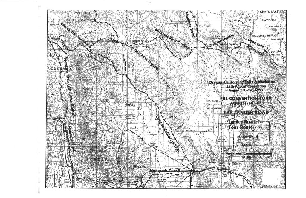
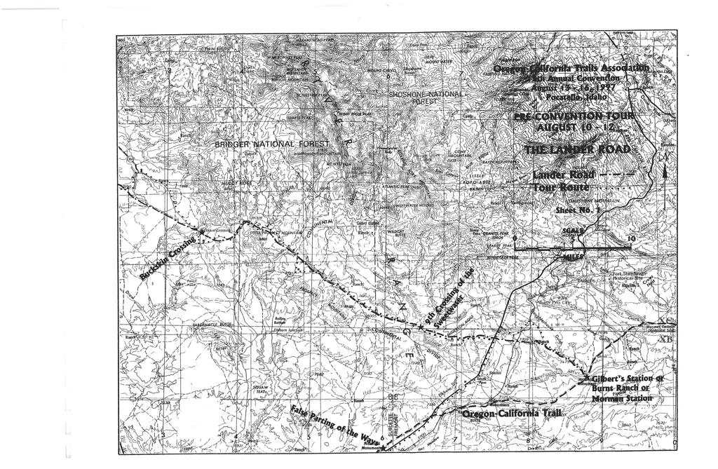
5 LANDER ROAD TOUR SITES Special thanks to Fred Dykes, OCT A member of Pocatello who, after the route and site information had been assembled, prepared the copy- ready color map we are using. The following are some of the sites we will be seeing on the Lander Road Tour: BURNT RANCH --- This location is the ninth and last crossing of the Sweetwater River on the main Oregon-California Trail. The Seminoe Cutoff from the east rejoined the main trail here on the south side of the river. It is also the beginning point for the Lander Road which headed west-northwest from here toward Fort Hall. All of the main routes and alternates went on to the southwest from here. This site was known variously as Gilbert's Station, Gilbert's Fort, or Gilbert's Store, named after the store proprietor H. L. Gilbert, who, according to Lander's Emigrant Guide, would show people how to get onto the Lander Road. It was later known as U. S. Mail Station #31, the Upper Sweetwater Station, and South Pass Station. It served as a stagecoach station, a Pony Express Station and a telegraph relay station. For a time, there was a Mormon mail station on the south bank. From 1862 to 1868, a unit of the 11th Ohio Volunteers was garrisoned at this site to protect both the Oregon-California Trail and the Lander Road. A sketch of the military quarters here was made by Lt. Caspar Collins sometime before his death in 1865, which showed the rooms, stables, parade ground, and telegraph installation. Shortly after the troops left, it was burned by Indians. Later rebuilt as a ranch house, it was burned again. Thus the enduring name of 'Burnt Ranch'. Frederick Lander stationed one of his trusted men, Charles H. Miller, at Gilbert's Station in 1859 to promote the advantages of using Lander's new cutoff. Mormons and others who owned toll bridges, ferries, and trading posts also stationed representatives at this site to promote their sites on the main trail. This competition resulted in a quarrel and Miller was shot and killed the next year. He is buried on the high ground north of the site. This was a popular campsite and many diary writers mentioned this site by its various names, including 0. Allen in 1858, Sir Richard Burton in 1860, Henry R. Herr in 1862, and William H. Jackson in A slate marker was erected here in 1913 and is inscribed "BURNT RANCH, OREGON, CAL TRAIL 1913". It is in an enclosure just west of the existing buildings. Burnt Ranch is on private property and is owned by the Hellyer family of Lander, WY. They have very generously allowed us to visit this site during our tour. NOTE: For more information on Burnt Ranch, see Historic Sites along the Oregon Trail, by Aubrey L. Haines (Patrice Press, Gerald, Mo., 1981), p LANDER CUTOFF MARKER - BIGHW AY Erected by the BLM and the Sublette County Historical Society, it tells the story off.w. Lander's improved wagon road as a shortcut to the Snake River, also avoiding the deserts to the south and providing more wood, water, and forage. 1
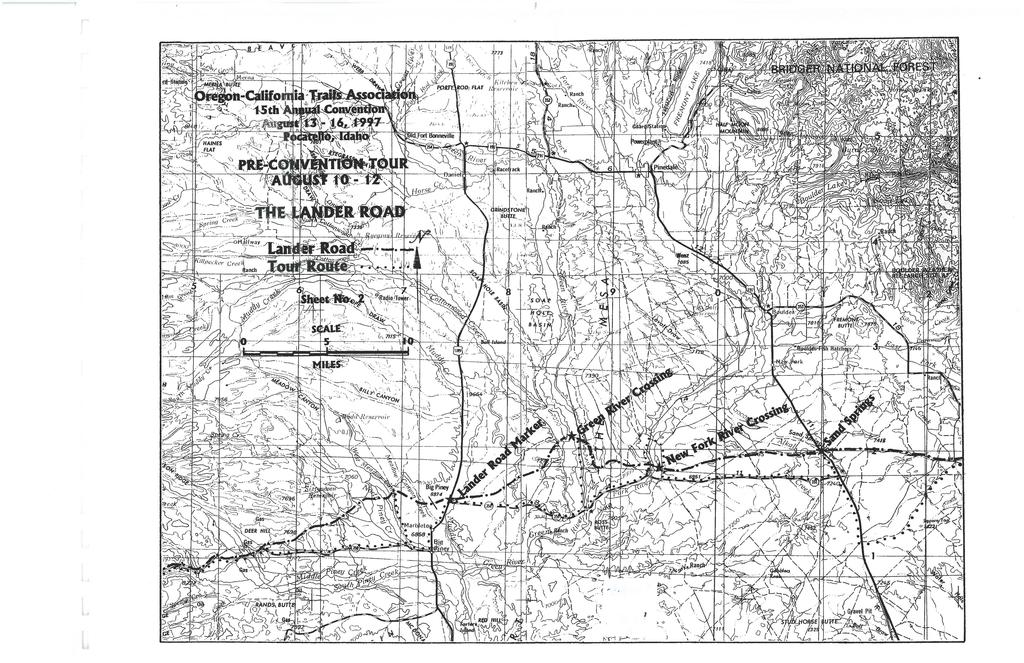
6 SWEETWATER CROSSING -- As our maps state, this is the ninth crossing of the Sweetwater for the Lander Road emigrants, as the crossing at Burnt Ranch was the ninth crossing for emigrants on the main trail. Lander Creek enters it just downstream and we will cross Lander Creek about 1 Yz miles west of here. As we will discover, the crossing may not be as exciting as the descent down to it from the plateau. Lander's Emigrant Guide said this crossing was miles from Gilbert's Station (Burnt Ranch). CONTINENTAL DIVIDE --- As imperceptible as at South Pass, the continental divide in this area fits tightly in between Lander Creek and Little Sandy Creek about twelve miles west of the Sweetwater Crossing. BUCKSKIN CROSSING --- Used as early as the fur era and by Bonneville and Fremont, this crossing of the Big Sandy River may have been named for Buckskin Joe, who according to local legend, used this site for a cabin for his family. The Big Sandy was named by William Ashley in Lander's Emigrant Guide says ''Hard pitchy road. A steep pitch to go down to the river", and "5. 00 miles from the Little Sandy crossing and miles from Gilbert's Ranch". SAND SPRINGS --- This BLM- Sublette Co. HIS marker on the west side of highway #191 about a mile north of highway #3 51 notes this site on the trail which was called "Grass Spring" by Lander's Emigrant Guide. The Guide also said that it was 8.15 miles from Big Sandy and miles from Gilbert's Station. A Lander Cutoff monument is on the East Side of the highway. NEW FORK RIVER CROSSING --- Also called the First Fork of the Green River or the East Fork, this was the first major river crossing on the Lander Road, just north of highway #351. The crossing used a large island in the center of the river, and the Guide said the river was twenty to thirty yards wide on each side of the island. It further suggested that wagon beds may need to be raised on their bolsters, because in the spring the river may be three to four feet deep miles from Grass Spring and miles from Gilbert's Station. GREEN RIVER CROSSING --- 5Yz miles from the New Fork, this was also a major crossing. Lander, by 1859, collected emigrant's signatures on a petition for a bridge here, but was not successful in convincing the Department of the Interior. The crossing site is not easily accessible and the river is spread out across the valley in several meanders. LANDER ROAD MARKER --- The Lander Road crossed here at the intersection of highways #351 and #189 at the fairgrounds. The marker is identical to the one on highway # 191 at Sand Spring. Marbleton and Big Piney villages are two or three miles south of here. End of the first day 2
7 PINEY CREEKS --- The trail for the first twenty miles west of highway # 189 crosses many branches of the North, Middle, and South Piney Creeks. All these creeks run into Green River just southeast of the village of Big Piney. PINEY CANYON --- For the next 7 or 8 miles we will be in this canyon through which courses South Piney Creek, which flows generally east. We will cross the creek several times. This was the first extensive construction work on the Lander Road. EMIGRANT GRAVES -- Many grave sites exist through this canyon, several of which have been marked by the Sublette County Historical Society, and are noted on the tour maps. FORT SNYDER --- At the head of Piney Canyon was the staging area in 1858 for much of the construction materials and equipment used for the Lander Road. A crude structure was built called Fort Snyder, which was named after James Snyder, Lander's Commissary Officer. This site was also called Fort Piney. THOMPSON PASS --- Named for Jacob Thompson, Secretary of the Interior in Buchanan's administration who was Lander's boss. There are several miles of good hiking along the trail in this area, which is still visible because it was used well into this century, even with automobiles. ELIZABETH PAUL GRAVE --- The 32-year-old wife of Thomas Paul, who died in childbirth in The extended Paul Family Party was from Indiana and had joined up with the Kennedy Party for the trek west. This wagon train would later be involved in the Massacre Rocks Indian attack on the Snake River, as they went to the aid of the attacked trains. None of their group was killed, but some were wounded in the running battle. LaBARGE MEADOWS --- A popular camping place. The William Smedley wagon train likely camped here before they found the remains of trader John Campbell and his wagons after an Indian attack in WAGNER PASS --- Named for William H. Wagner, topographer, meteorologist, engineer, and physician for Lander's 1858 party. The pass is elevation 9025 feet which is not the highest point on the Lander Road. Just a few miles west the elevation reaches 9113 feet. SALT RIVER VALLEY --- The trail descends into this beautiful valley and runs generally north for about twenty miles, crossing the Salt River in the process. Many diaries record the beauty of this peaceful valley and after the hard going of previous days this valley became a time to gather strength for challenges yet to come. The Guide says the Salt River Crossing is forty miles west of Fort Piney. In this century it has been called Star Valley. End of the second day ONEIDA SALT WORKS --- In the northwest corner of the Salt Creek Valley, the trail crosses the Idaho border and turns to the west up Smoky Creek (now called Stump Creek, 3
8 named for the prominent part-owner of the Oneida Salt Works, John H. Stump) and Red Willow Creek (now called Tygee Creek) for about ten miles to the area where the Oneida Salt W arks was in the 1860' s and 18 70' s. Lander's Guide says "Surface of ground in many places white with pure and excellent salt. A good laying up place to salt your stock". A salt brine still flows from the ground across several acres of a rocky flat area, which when evaporated yields nearly pure table salt. TERRACE CANYON - We will backtrack from here, because there is no road over Terrace Canyon, and pick up the trail on the other side of the mountain near Lane's Grave. The trail route up Terrace Canyon is very steep and difficult; hiking it is possible, although strenuous. There are some interpretive markers along the way which show the rock ledges and aspen carvings that remain. Strangely, Lander's Guide makes light mention of this difficult climb. LANE'S GRAVE --- Enclosed in a fenced area adjacent to the ranch house of Lane's Creek Ranch which is near Lane's Creek. J. W. Lane died July 18, 1859 at about 50 years of age. Little else is known. The current owner of the ranch is the Lloyd family who have very generously allowed us to visit the grave site and their ranch. BLACKFOOT RIVER CROSSING --- The trail crosses the north end of the present Blackfoot Reservoir. The actual crossing is just west of the reservoir. On the East side of the reservoir is where the road to Montana went toward Idaho Falls and carried salt to the miners in Montana in the 1860's. This crossing is 199 miles from Gilbert's Station and about 52 miles from the Salt River. Lander had a staging camp near here on his 1859 trip to do the final touch-up on the work on the west end of the Lander Road. PORTNEUF RIVER CROSSING --- Lander's Guide said "Aspen grove'and good grass at the crossing". The crossing is sixteen miles from the Blackfoot River Crossing. OREGON TRAIL JUNCTION --- This is the main trail that comes from Soda Springs and is fourteen miles from the PortneufRiver according to the Guide. Fort Hall was now only about twenty-five miles away. This junction is miles from Gilbert's Station per the Guide. FORT HALL --- One of the most important sites on the entire Oregon-California Trail, it was first erected in 1834 by Nathaniel J. Wyeth on the east bank of the Snake River. It was sold to the Hudson's Bay Company in 1837 and later remodeled, but by 1849 when the fur business had long passed away, it was only serving the emigrant traffic. Abandoned in This concludes the Tour All ofus who worked on this pre-convention tour of the Lander Road sincerely hope that it has been enjoyable and educational. We also hope that the tour has enhanced your appreciation of this chapter in the Westward Movement. Ross Marshall 4
9

10
11
12
Mormon Trail, The. William Hill. Published by Utah State University Press. For additional information about this book
 Mormon Trail, The William Hill Published by Utah State University Press Hill, William. Mormon Trail, The: Yesterday and Today. Logan: Utah State University Press, 1996. Project MUSE., https://muse.jhu.edu/.
Chapter 5 Utah Studies
 Chapter 5 Utah Studies As the beaver trapping industry died out, many mountain men started sharing their stories of west with others. People were fascinated by the stories about California and the Oregon
Mormon Trail, The. William Hill. Published by Utah State University Press. For additional information about this book
 Mormon Trail, The William Hill Published by Utah State University Press Hill, William. Mormon Trail, The: Yesterday and Today. Logan: Utah State University Press, 1996. Project MUSE., https://muse.jhu.edu/.
Chapter 4 MOUNTAIN MEN
 Chapter 4 MOUNTAIN MEN Jedediah Smith Ethnicity: American Company: Ashley-Henry Company Location: All over Utah Accomplishments: Leader among trappers First to travel the length and width of Utah Proved
Utah. Copyright 2010 LessonSnips
 Utah Utah is located in the middle of the American Southwest between Nevada on the west; Arizona to the south; Colorado to the east; and Idaho and Wyoming to the north. The corners of four states (Utah,
Chapter 11, Section 1 Trails to the West. Pages
 Chapter 11, Section 1 Trails to the West Pages 345-349 Many Americans during the Jacksonian Era were restless, curious, and eager to be on the move. The American West drew a variety of settlers. Some looked
Territorial Utah and The Utah War. Chapter 9
 Territorial Utah and The Utah War Chapter 9 Mormon and Natives Interaction When Brigham Young and the Mormons arrived in Utah the Natives welcomed them. The Natives were excited to have the Mormons in
Oregon Country. Adams-Onís Treaty. Mountain Men. Kit Carson. Oregon Trail. Manifest Destiny
 Chapter 11 Section 1: Westward to the Pacific Oregon Country Adams-Onís Treaty Mountain Men Kit Carson Oregon Trail Manifest Destiny Chapter 11 Section 2: Independence for Texas Davy Crockett The area
Living In Territorial Utah: culture, business, transportation, and mining. Timeline. Schools in Utah Territory
 Slide 1 Living In Territorial Utah: culture, business, transportation, and mining Chapter 8 Slide 2 Timeline 1850 The University of Deseret (U of U) opens. Utah s first newspaper, the Deseret News, is
Mormon Trail, The. William Hill. Published by Utah State University Press. For additional information about this book
 Mormon Trail, The William Hill Published by Utah State University Press Hill, William. Mormon Trail, The: Yesterday and Today. Logan: Utah State University Press, 1996. Project MUSE., https://muse.jhu.edu/.
CHAPTER 4. The Great Encounter. American Indians Meet Explorers and Mountain Men
 CHAPTER 4 The Great Encounter American Indians Meet Explorers and Mountain Men Introduction During 1765, when the American Revolution was starting to unfold, Spanish missionaries began crossing into Utah.
Doctrine & Covenants and Church History Study Squares
 Doctrine & Covenants and Church History Study Squares As you study the Doctrine and Covenants, use this book to record things you learn in each chapter. Pick a favorite doctrine or principle, something
Territorial Utah and The Utah War. Chapter 9
 Territorial Utah and The Utah War Chapter 9 Nativists Many Americans alarmed at growing number of immigrants Nativists want America for the Americans Preserve country for native-born white citizens Favored
MANIFEST DESTINY Louisiana Territory
 Louisiana Territory 1. Southwest Santa Fe Trail- Independence, MO to Santa Fe, NM, 1 st attempt thru TX and Mexico William Becknell- developed trade route, caravan system - traded goods to settlers 2.
NOVEMBER 2017 LESSON, ARTIFACT, AND MUSIC. November 2017 DUP Lesson Cove Fort Ellen Taylor Jeppson
 NOVEMBER 2017 LESSON, ARTIFACT, AND MUSIC November 2017 DUP Lesson Cove Fort Ellen Taylor Jeppson The great Mormon pioneer migration to the West began in 1847 when the pioneers made their way to the Salt
Appendix A. Rocky Mountain Trip List, 1804 to Dep Date From Arv Date To Party, Route and Notes
 Appendix A Rocky Mountain Trip List, 1804 to 1843 May 14 1804 St Louis Dec 7 1805 Columbia Lewis & Clark Expedition via Upper Missouri» Mar 23 1806 Oregon Sep 23 1806 St Louis and across the Rockies to
Map Exercise Routes West and Territory
 Routes to the West Unit Objective: examine the cause and effects of Independence Movements west & south of the United States; investigate and critique U.S. expansionism under the administrations of Van
Chapter 9 UTAH S STRUGGLE FOR STATEHOOD
 Chapter 9 UTAH S STRUGGLE FOR STATEHOOD Introduction In 1849, 2 years after first settling into Utah, Mormon leaders drew up a large region on a map. This new territory would be called the State of Deseret.
The Great Encounter: American Indians Meet Explorers & Mountain Men
 Slide 1 CHAPTER 4 The Great Encounter: American Indians Meet Explorers & Mountain Men Slide 2 The Mood Just as different groups of Native American Indian people had displaced other groups who lived in
Wife of Anson Call
 A life sketch of Ann Mariah Bowen Call 1834 1924 Wife of Anson Call Ann Mariah Bowen Call was born January 3, 1834, in Bethany, Gennesse County, New York. In her early childhood she, with her parents,
Chapter 9. Utah s Struggle for Statehood
 Chapter 9 Utah s Struggle for Statehood Introduction In 1849, 2 years after first settling into Utah, Mormon leaders drew up a large region on a map. This new territory would be called the State of Deseret.
CHAPTER 7. American Indian and Pioneers (Clash of Cultures)
") CHAPTER 7 American Indian and Pioneers (Clash of Cultures) Essential Question 14 One week after the Mormons moved, the Mormons watched a bad fight, Shoshones against the Utes. Why didn t they help stop
CHAPTER 7 American Indian and Pioneers (Clash of Cultures) Essential Question 14 One week after the Mormons moved, the Mormons watched a bad fight, Shoshones against the Utes. Why didn t they help stop
Mormon Trail, The. William Hill. Published by Utah State University Press. For additional information about this book. Accessed 4 May :17 GMT
 Mormon Trail, The William Hill Published by Utah State University Press Hill, William. Mormon Trail, The: Yesterday and Today. Logan: Utah State University Press, 1996. Project MUSE., https://muse.jhu.edu/.
From the colonial days forward, Americans had continued to move westward. At first, trails were found through the Appalachians as settlers began to
 From the colonial days forward, Americans had continued to move westward. At first, trails were found through the Appalachians as settlers began to move into the fertile lands stretching toward the Mississippi
SETTLEMENTS TRANSPORTATION & MINING. Chapter 9 Utah Studies
 SETTLEMENTS TRANSPORTATION & MINING Chapter 9 Utah Studies HUNTSVILLE-1860 Seven families led by Jefferson Hunt established Huntsville in 1860. They found Shoshone living in the Ogden Valley and paid a
Between the early 1830s and the mid 1850s, a new political party called the Whigs ran in opposition against the Democrat party of Andrew Jackson.
 Between the early 1830s and the mid 1850s, a new political party called the Whigs ran in opposition against the Democrat party of Andrew Jackson. They believed in congressional supremacy instead of presidential
I wonder, I noticed, It was interesting to me that...
 I wonder, I noticed, It was interesting to me that... 4th Grade Responses to Patty Reed s Doll Chapter 1 Background Info: Springfield, Illinois, 1846 Patty and her family were going on an exciting, and
Expanding West. Trails to the West. The Texas Revolution. The Mexican-American War. The California Gold Rush. Section 1: Section 2: Section 3:
 Expanding West Section 1: Trails to the West Section 2: The Texas Revolution Section 3: The Mexican-American War Section 4: The California Gold Rush Section 1: Trails to the West Key Terms & People: John
Joel Hills Johnson wrote:
 WEDNESDAY, SEPTEMBER 19TH Started early and traveled about 8 miles and camped for the night without water five miles from Little Sandy. THURSDAY, SEPTEMBER 20TH Started about sunrise without breakfast
The Mormon Trail: In search of the promised land
 Name Period US History 8 Mr. Tripodi The Mormon Trail: In search of the promised land Directions: 1. Read the paragraph. 2. Present the paragraph a different way. Make meaning out of what you are reading
EXPLORERS, MOUNTAIN MEN, & PIONEERS
 UNIT 3: EXPLORERS, MOUNTAIN MEN, & PIONEERS Chapters 4, 5, 6 The Spanish Come to Utah After the explorations of Christopher Columbus, the Spanish sent other explorers to claim land in North and South America
4. Why did the Mormons move from place to place in their early history? Describe some of the events and issues that led to this movement.
 Name Today s Date Test Date Hour Chapters 6 and 7 Study Guide Their Faces Towards Hope and Settling the Great Basin Notes A Journey for Religious Freedom (pg. 98-99) Chapter 6 1. What was the Great Awakening?
Mormon Trail, The. William Hill. Published by Utah State University Press. For additional information about this book
 Mormon Trail, The William Hill Published by Utah State University Press Hill, William. Mormon Trail, The: Yesterday and Today. Logan: Utah State University Press, 1996. Project MUSE., https://muse.jhu.edu/.
Killed - None Wounded - None Fooled - Everybody
 1857-1858 Killed - None Wounded - None Fooled - Everybody Mormon War Utah War Utah Expedition Johnston s Army Buchanan s Folly Buchanan s Blunder Contractor s War Echo Canyon War President Brigham Young
Early Settlers Fact Test 1. Name a mountain range beginning with R where you would find mountain men? 2. Which 2 US States were the early settlers
 Indians fact test 1. What n describes Indians way of life 2, Which dance involved piercing skin 3 What word means marriage to more than one wife 4. Which body part did Indians take after killing an enemy
Section 1 The Oregon Country: The U.S. was a nation that was destined to be a country that reached from coast to coast.
 Chapter 14 Manifest Destiny Section 1 The Oregon Country: The U.S. was a nation that was destined to be a country that reached from coast to coast. Settlers Move West: The Oregon Country included the present
Assessment: Life in the West
 Name Date Mastering the Content Circle the letter next to the best answer.. Assessment: Life in the West 1. Which of these led to the Lewis and Clark expedition in 1804? A. Monroe Doctrine B. Gadsden Purchase
The Mormons and the Donner Party. BYU Studies copyright 1971
 The Mormons and the Donner Party The Mormons and the Donner Party Eugene E. Campbell A busload of tourists, enroute from San Francisco to Salt Lake City, had stopped at the large stone monument near Donner
ALONG THE OREGON TRAIL
 ALONG THE OREGON TRAIL Mark Hattan, with his bride of six days - Martha, together with his sister, Jane Hattan Baxter, and Horace Baker left Illinois in April 1845 to join the great wagon train from Missouri
CONTINUE SOUTH ON HWY. 11 FOR 1/4 MILE TO OLD MILITARY ROAD, TURN WEST:
 The area described in this brochure is part of present day Jackson Township in Hall County and Shelton Township in Buffalo County. When the original Mormon Trail came through, there were families already
TruthQuest History American History for Young Students II ( ) Maps, Timeline & Report Package
 Maps, Timeline & Report Package") 1 A J T L Grades 1 and up TruthQuest History American History for Young Students II (1800-1865) Maps, Timeline & Report Package A Journey Through Learning www.ajourneythroughlearning.com 2 Please check
1 A J T L Grades 1 and up TruthQuest History American History for Young Students II (1800-1865) Maps, Timeline & Report Package A Journey Through Learning www.ajourneythroughlearning.com 2 Please check
Mormon Trail Network in Nebraska, : A New Look
 Mormon Trail Network in Nebraska, 1846 1868: A New Look Mormon Trail Network in Nebraska, 1846 1868: A New Look Stanley B. Kimball For more than twenty years during the mid-nineteenth century, between
From Emigration Canyon to City Creek: Pioneer Trail and Campsites in the Salt Lake Valley in 1847
 The Pioneers' First View of Salt Lake Valley by Utah artist Lewis A. Ramsey depicts Brigham Young's party on the south side of Emigration Canyon onjuly 24, 1847. Frontispiece in S. A. Kenner's Utah As
Mexican-American War Act-It-Out
 Florida Act-It-Out Follow the narration below to create an act-it-out about Florida. When the narrator says Action! the actors will move, act, and speak as described. When the narrator says Audience! the
Bell work. What do you think when you hear the term Manifest Destiny?
 Bell work What do you think when you hear the term Manifest Destiny? Manifest Destiny and the War with Mexico Essential Question How did the idea of Manifest Destiny affect the movement of Americans across
Name: Class Period: Date:
 Name: Class Period: Date: Unit #2 Review E George Washington H Jay s Treaty D Pinckney s Treaty G Treaty of Greenville K Whiskey Rebellion B Marbury v. Madison A. The greatest U.S. victory in the War of
WESTWARD EXPANSION II. The Expansion
 WESTWARD EXPANSION II The Expansion GOALS: WHAT I NEED TO KNOW How did the Louisiana Purchase, Texas, the Alamo, the Oregon Trail, California Gold Rush, and development of mining towns help Westward Expansion
The General William Henry Harrison Trail through Portions of Vermillion County and Warren County, Indiana Written 11 October 2015 by Curtis L.
 The General William Henry Harrison Trail through Portions of Vermillion County and Warren County, Indiana Written 11 October 2015 by Curtis L. Older Five Probable Points Along the Harrison Trail, including
In the 1840s, westward expansion led Americans to acquire all lands from the Atlantic to Pacific in a movement called Manifest Destiny
 In the 1840s, westward expansion led Americans to acquire all lands from the Atlantic to Pacific in a movement called Manifest Destiny Obvious Future Americans flooded into the West for new economic opportunities
It was near this spot that J. D. Lee operated his ferry across the Colorado. Photo Paul Fretheim
 It was near this spot that J. D. Lee operated his ferry across the Colorado. Photo Paul Fretheim CLICK IN IMAGE TO OPEN A 360 PANO OF THIS LOCATION. Topo Map: Glen Canyon Dam; Coordinates: 36 52 N - 111
The Americans (Survey)
") The Americans (Survey) Chapter 9: TELESCOPING THE TIMES Expanding Markets and Moving West CHAPTER OVERVIEW The economy of the United States grows, and so does the nation s territory, as settlers move west.
The Americans (Survey) Chapter 9: TELESCOPING THE TIMES Expanding Markets and Moving West CHAPTER OVERVIEW The economy of the United States grows, and so does the nation s territory, as settlers move west.
Great Pioneer. Projects. Sample file. You Can Build Yourself. Rachel Dickinson
 Great Pioneer Projects You Can Build Yourself Rachel Dickinson Nomad Press A division of Nomad Communications 10 9 8 7 6 5 4 3 2 1 Copyright 2007 by Nomad Press All rights reserved. No part of this book
United States History. Robert Taggart
 United States History Robert Taggart Table of Contents To the Student.............................................. v Unit 1: Birth of a Nation Lesson 1: From Colonization to Independence...................
Scholar discusses Joseph Smith's 1844 presidential election campaign
 Scholar discusses Joseph Smith's 1844 presidential election campaign By R. Scott Lloyd@RScottLloyd1 Published: Sept. 22, 2016 1:25 p.m. Updated: Sept. 22, 2016 1:27 p.m. Susan Easton Black, in lecture
Who were the Mountain Men?
 Mountain Men Who were the Mountain Men? Inspired by the adventures of Lewis and Clark, thousands of explorers and fur trappers roamed the American Rocky Mountains from about 1810 to the early 1840s. Today
The Mormons and the Donner Party
 BYU Studies Quarterly Volume 11 Issue 3 Article 9 7-1-1971 The Mormons and the Donner Party Eugene E. Campbell Follow this and additional works at: https://scholarsarchive.byu.edu/byusq Recommended Citation
Who were the Mormons and why did they decide to Head West?
 Who were the Mormons and why did they decide to Head West? Learning Objectives: To understand who the Mormons were and why they were unpopular in the East. To assess how successful their move West was
Thomas Clark Jr. Pioneer of 1848, 1851 and compiled by Stephen Clark
 Thomas Clark Jr. Pioneer of 1848, 1851 and 1853 compiled by Stephen Clark 1848 FIRST TRIP TO OREGON: In the year of 1848, Thomas Clark Jr. immigrated to the Oregon Territory from Illinois. The only thing
Western Trails & Settlers
 Western Trails & Settlers Today, you will be able to: Identify selected racial, ethnic, and religious groups that settled in the US and reasons for immigration Westward Trails & Settlers Directions: 1.
Warm- Up 3/21 List three mo4ves, or reasons, for why the Lewis and Clark expedi4on explored the West.
 Warm- Up 3/21 List three mo4ves, or reasons, for why the Lewis and Clark expedi4on explored the West. Who Were the Explorers? In the early 1800s, a number of expedi4ons set out from the United States to
American Westward Expansion
 Chapter 9 Americans Head West In 1800 less than 400,000 settlers lived west of the Appalachian Mountains. By the beginning of the Civil War, more Americans lived west of the Appalachians than lived along
Utah This is the Place! 4 th grade program March 23 rd, :15 pm
 Utah This is the Place! 4 th grade program March 23 rd, 2016 2:15 pm Jade: On January 4, 1896 Utah was admitted to the Union as the 45 th state. As students of Trailside Elementary School, we would like
Other Awards. Council Aquatic Awards GRAND CANYON COUNCIL, BSA. See the Council s Aquatic Awards book for information on all the Aquatic Awards.
 Other Awards Council Aquatic Awards See the Council s Aquatic Awards book for information on all the Aquatic Awards. 116 Arizona Trail 117 Arizona Trail Passages Mexico to Utah Section # Name Passage Description
Chapter 9 Expanding Markets and Moving West
 Chapter 9 Expanding Markets and Moving West The Market Revolution factory system changed the lives of workers and consumers. People will stop growing and making things for their own survival and begin
It is Thought They Will be Shot on the Grounds : A Letter from Missourian Josiah Hendrick During the Mormon-Missouri Conflict
 Walker: A Letter from Josiah Hendrick 175 It is Thought They Will be Shot on the Grounds : A Letter from Missourian Josiah Hendrick During the Mormon-Missouri Conflict Kyle R. Walker In the fall of 1838,
C Colman-Hayter Family Papers, linear feet
 C Colman-Hayter Family Papers, 1839-1900 84.2 linear feet This collection is available at The State Historical Society of Missouri. If you would like more information, please contact us at shsresearch@umsystem.edu.
Manifest Destiny,
 Manifest Destiny, 1810 1853 Westward expansion has political, economic, and social effects on the development of the United States. Stephen Fuller Austin, 19thcentury American frontiersman and founder
Manifest Destiny and Andrew Jackson
 Manifest Destiny and Andrew Jackson Study online at quizlet.com/_204f5a 1. 13 colonies 4. Andrew Jackson 2. 1849 The original states : Connecticut, Delaware, Georgia, Maryland, massachusetts, New jersey,
The DONNER Party. A test of survival...
 The DONNER Party A test of survival... Be sure to have a Learning Journal out! You will be asked to complete a series of tasks as this slide show progresses. Be ready when you see this: Learning Objectives:
*On your sticky note depict (draw) the following two words. Acquire. Expansion
 the following two words. Acquire. Expansion") *On your sticky note depict (draw) the following two words. Acquire Expansion The Northwest Ordinance of 1787 1. What did the Northwest Ordinance of 1787 establish? This act established the principles
*On your sticky note depict (draw) the following two words. Acquire Expansion The Northwest Ordinance of 1787 1. What did the Northwest Ordinance of 1787 establish? This act established the principles
(2) SIGNIFICANT THEMES AND HIGHLIGHTS
 SIGNIFICANT THEMES AND HIGHLIGHTS") 13 Moving West (1) CHAPTER OUTLINE Narcissa Whitman her husb Marcus, were among thouss of Americans who played a part in the movement into the trans-mississippi West between 1830-1865. The chapter also
13 Moving West (1) CHAPTER OUTLINE Narcissa Whitman her husb Marcus, were among thouss of Americans who played a part in the movement into the trans-mississippi West between 1830-1865. The chapter also
Westward Expansion. What did the United States look like before Westward Expansion?
 Westward Expansion What did the United States look like before Westward Expansion? In 1803, Thomas Jefferson, the third president of the United States, purchased 828,000 square miles from France. This
The Iowa Trek of 1846: The Brigham Young Route from Nauvoo to Winter Quarters
 Ensign» 1972» June The Iowa Trek of 1846: The Brigham Young Route from Nauvoo to Winter Quarters By Stanley B. Kimball Stanley B. Kimball, The Iow a Trek of 1846: The Brigham Young Route from Nauvoo to
THE LATE GREAT PUGET SOUND MERIDIAN. Washington State s Own Principal Meridian. by Denny DeMeyer
 THE LATE GREAT PUGET SOUND MERIDIAN. Washington State s Own Principal Meridian by Denny DeMeyer Pausing briefly in a clearing in the forest while ascending a ridge just south of Bellingham, the surveyors
J. NEILSON BARRY, portland, Oregon.
 A VALUABLE MANUSCRIPT WHICH MAY BE FOUND In 1852 there was a manuscript journal with an alleged ac-. count of a journey by four shipwrecked sailors from the Oregon coast to the Red River, and the following
The Saints Build Winter Quarters
 Lesson 39 The Saints Build Winter Quarters Purpose To help the children understand that great things can be accomplished when people cooperate and serve each other. Preparation 1. Prayerfully study Mosiah
R Barnitz, Franklin Hoke, , Papers, MICROFILM 5 folders and 2 volumes INTRODUCTION
 R Barnitz, Franklin Hoke, 1836-1910, Papers, 1860-1894 164 MICROFILM 5 folders and 2 volumes This collection is available at The State Historical Society of Missouri. If you would like more information,
UTAH...THIS IS THE PLACE
 , Gary Francis Music- Gary Francis UTAH...THIS IS THE PLACE (The State Song of Utah) Utah! People working together Utah! What a great place to be. Blessed from Heaven above. It s the land that we love.
The Third Sunday after Epiphany Jonah 3:1-5,10 January 23, Corinthians 7:29-31 Cycle B Mark 1:14-20
 The Third Sunday after Epiphany Jonah 3:1-5,10 January 23, 2018 1 Corinthians 7:29-31 Cycle B Mark 1:14-20 Grace, Mercy, & Peace from God our Father & our Lord, Jesus Christ. Amen Do you realize that the
Major Indian White Conflicts U T A H H I S T O R Y C H A P T E R 7
 Major Indian White Conflicts U T A H H I S T O R Y C H A P T E R 7 Native Americans vs. Mormons: Conflicts happened over a period of time. They were sometimes violent, but were usually resolved peacefully.
Deer Range Ranch Skutumpah Rd MM 500 Cannonville, UT
 NAI Utah South is pleased to offer the following exclusive listing: FOR SALE Skutumpah Rd MM 500 Cannonville, UT Click For More Info Click For More Info 640+/- Acre South Central Utah Cattle Ranch Sweeping
Scipio Africanus Kenner
 Scipio Africanus Kenner Scipio Africanus Kenner was born 14 May 1846 in Saint Francisville, Clark, Missouri. He was the oldest of four children of Foster Ray Kenner and Sarah Catherine Kirkwood. He was
Wichita Stamp Club Newsletter
 Wichita Stamp Club Newsletter Vol. 83, No. 4, April, 2015 Neal E. Danielson Editor Go Fly A Stamp Click on a link below in order to go directly to the article. Kingman County, Kansas The first in a series
Expanding West. Chapter 11 page 342
 Expanding West Chapter 11 page 342 Trails to the West Section 1 Americans Move West In the early 1800s, Americans pushed steadily westward, moving even beyond the territory of the United States Many of
Name Period Parent Signature (EC) LESSON PACKET NEVADA 7 th Social Studies DUE DATE:
 LESSON PACKET NEVADA 7 th Social Studies DUE DATE:") Name Period Parent Signature (EC) LESSON PACKET NEVADA 7 th Social Studies DUE DATE: Much of ancient Nevada use to be covered by waters from ancient Lake Lahontan. Indians from Nevada included the Washoe,
Name Period Parent Signature (EC) LESSON PACKET NEVADA 7 th Social Studies DUE DATE: Much of ancient Nevada use to be covered by waters from ancient Lake Lahontan. Indians from Nevada included the Washoe,
Bates, Also Known As Murphy, Has Three Graves in Sturgis
 Sunday, August 09, 2009 Remembering Custer s Last Command in South Dakota Bates, Also Known As Murphy, Has Three Graves in Sturgis By Jack McCulloh Pictures by Scott Nelson The geography now South Dakota,
Westward Expansion & America s Manifest Destiny
 Westward Expansion & America s Manifest Destiny Manifest Destiny Term first coined by newspaper editor, John O Sullivan in 1845... the right of our manifest destiny to over spread and to possess the whole
Manifest Destiny and Westward Expansion
 Manifest Destiny and Westward Expansion Van Buren, Harrison, and Tyler Martin Van Buren was the 8th President from 1837-1841 Indian Removal Amistad Case Diplomacy with Great Britain and Mexico over land
10/18/ Explain at least one way in which the first Industrial/Market Revolution changed the American economy.
 10/18/2016 35. Explain at least one way in which the first Industrial/Market Revolution changed the American economy. 36. Of the inventions of the first Industrial Revolution that we have discussed thus
William T. Sherman on the western railroads,
 1 Introduction After Ulysses S. Grant s election as president, William Tecumseh Sherman, known for leading the March to the Sea in the closing months of the Civil War, was appointed commanding general
Copyright History Matters 2015.
 Copyright History Matters 2015. Social Studies Name: Directions: Use the handout to complete the following timeline assignment. Task Overview Westward Expansion unfolded as a series of key events that
winter Fur Trade Rendezvous in Cache Valley By Stephen Darley*
 Newsletter of the Jedediah Smith Society University of the Pacific, Stockton, California Much has been made over the last thirty five years of the competition between Cove, Utah, and Hyrum, Utah, in terms
Old Sandy Baptist Church Graveyard
 Old Sandy Baptist Church Graveyard By Dave Hallemann This original church cemetery is located in T41 R4 Survey 2018 in what was at one time called the Upper Sandy Settlement off Highway 21. It was visited
The Pew Charitable Trusts Utah: Grand Staircase-Escalante National Monument Survey. Screeners
 The Pew Charitable Trusts Utah: Grand Staircase-Escalante National Monument Survey Fielded July 26 31, 2016 Among 600 registered voters in Utah with an oversample of 100 in select counties in Southeastern
The. Lytle R anch Preserve
 The Lytle R anch Preserve Mission Statement The Lytle Ranch Preserve is a remarkable desert laboratory located at the convergence of the Great Basin, Colorado Plateau, and Mojave Desert biogeographical
Unit 3 Part 2. Analyze the movement toward greater democracy and its impact. Describe the personal and political qualities of Andrew Jackson.
 Unit 3 Part 2 Trace the settlement and development of the Spanish borderlands. Explain the concept of Manifest Destiny. Describe the causes and challenges of westward migration. Explain how Texas won independence
Study Guide: Sunshine State Standards
 Ù Ç È É Ê Ë Ë Ë Ë Ë Ë Ë Ë Ë Ë Ë Ë Ë Ë Ë Ë Ë Ë Ë Ë Ë Ë Ë Ë Ë Ë Ë Ë Ë Ë Ë Ë Ë Ë Ë Ë Ë Ë Ë Ë Ë Ë Ë Ë Ë Ì È Í Ê Ë Ë Ë Ë Ë Ë Ë Ë Ë Ë Ë Ë Ë Ë Ë Ë Ë Ë Ë Ë Î Ï È Ð Ð Ë Ë Ë Ë Ë Ë Ë Ë Ë Ë Ë Ë Ë Ë Study Guide: Chapter
ABIGAIL SPRAGUE BRADFORD
 154 LIFE OF ARCHIBALD GARDNER ABIGAIL SPRAGUE BRADFORD Abigail Sprague Bradford Gardner came of good old English stock. Her forefather, William Sprague, came from England in.the ship "Abigail" in 1628
Salt Lake County (Utah). Records Management & Archives Salt Lake County Maps,
. Records Management & Archives Salt Lake County Maps,") Salt Lake County (Utah). Records Management & Archives Salt Lake County Maps, 1854-1972 Processed by: Ronda Frazier Date Completed: June, 2009 Salt Lake County Records Management & Archives 4505 South
Salt Lake County (Utah). Records Management & Archives Salt Lake County Maps, 1854-1972 Processed by: Ronda Frazier Date Completed: June, 2009 Salt Lake County Records Management & Archives 4505 South
HIST 1301 Part Three. 13: An Age of Expansion
 HIST 1301 Part Three 13: An Age of Expansion Manifest Destiny Trails West A belief in Manifest Destiny led many Americans to go west in the early 1800s. 2 min. 51 sec. [It is] our manifest destiny to overspread