THE EXACT SITE OF FORT WASHINGTON AND DANIEL DRAKE'S ERROR
|
|
|
- Clifford Bradford
- 5 years ago
- Views:
Transcription


1 THE EXACT SITE OF FORT WASHINGTON AND DANIEL DRAKE'S ERROR by ARTHUR G. KING, M.D. The establishment of Fort Washington in 1789 has been described as the greatest single event in Cincinnati history. The Fort offered protection to the pioneers who pushed west of Fort Harmar at Marietta, and encouraged them to settle at this intersection of two great natural routes of communication into the interior. It was the base of the operations which cleared the hostile Indians from Ohio and Indiana. Finally it lent publicity and prestige to Cincinnati as the capital of the Northwest Territory, out of which Ohio became the first state to emerge just 150 years ago. And yet, when the structure was razed after its abandonment in 1804, so little was thought of Fort Washington by the citizens of Cincinnati that its exact location was never determined officially. The sesquicentennial anniversary of Ohio is a fitting occasion to perform this service, particularly in the light of a recent discovery that makes it possible. Daniel Drake was apparently the first to recognize the historical value of memorializing the Fort. In his "Picture of Cincinnati," published in 1815, he indicated the location of the Fort on the accompanying map, but gave no evidence or reason for the selection of the site. This site was copied by Farnsworth in 1819 on the map which accompanied the first Directory of Cincinnati, so that it achieved a semi-official status. In 1902 Robert Ralston Jones, in his little history entitled "Fort Washington," tried to show how Drake arrived at his conclusions. His chief contribution to history was to call attention to a law-suit in December 1829 at which Daniel Drake testified as to the location of the Fort. Drake's testimony is a little inconsistent and is in conflict with the testimony of other witnesses. However, Jones used selected portions of Drake's statement to support Drake's original placement of the Fort, and the site has unfortunately been perpetuated in bronze. This location has often been questioned. For one thing it does not fit the excellent description given by the Reverend Oliver M. Spencer in his "Indian Captivity" (Waught and Mason edition,


2 Site of Fort Washington 129 New York, 1835, page 28). Speaking of Fort Washington as he saw it in 1791, he says: "On the top, and about 80 feet distant from the brow of the second bank, facing the river, stood Fort Washington, occupying nearly all the ground between Third Street and Fourth Street and between Ludlow Street and Broadway. This fort, of nearly a square form, had... four sides or walls, each about 180 feet long, which were constructed of hewed logs erected into barracks two stories high, connected at the corners by high pickets, with bastions or blockhouses, also of hewed logs, projecting about ten feet in front of each side of the fort, so that the cannon placed within them could rake its walls. Through the center of the south side, or front of the fort, was the principal gateway, a passage through this line of barracks about 12 feet wide and ten feet high... Appended to the fort on its north side, and enclosed with high palisades extending from its northeast and northwest corners to a blockhouse, was a small triangular space in which were constructed shops for the accommodation of artificers. Extending along the whole front of the fort was a fine esplanade about 80 feet wide, enclosed with a handsome paling on the brow of the bank." For another reason, Drake's location was militarily unsound. The Fort, as he placed it, would have been at a lower elevation than the broad plateau which extended northward from Third Street. Any Indian attackers from the north would have had a distinct advantage in observation, archery, and assault. Similarly the deep gully that later became Ludlow Street would have provided excellent defilade from the small-arms fire of the American troops within the Fort. Impetus for determining the exact location of the Fort came from the recent discovery by Mr. Fred P. Bounds, the construction superintendent for the Frank Messer Company, while digging foundations for a garage for the Western and Southern Life Insurance Company, at Third Street and Broadway. Great credit belongs to Mr. Bounds for recognizing the possible value of the logs which were uncovered, for connecting them from the very beginning with Fort Washington, and for taking the responsibility of continuing the excavation for historical purposes at considerable expense to his company. His account of the "find" was reported in The Engineer and Scientist on December 1, 1952


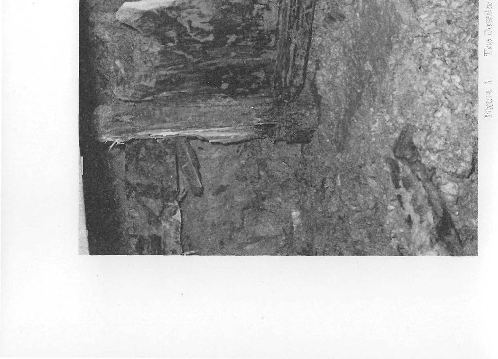

3 Figure 1. The Powder Magazine of Fort Washington in the Course of Excavation.


4 Site of Fort Washington 131 (volume 17, page 1), from which the following extracts are taken with his kind permission: "The logs had been hewed and notched at each end to fit into each other... They had laid the logs in a horizontal position... and had notched them to fit at the corners of an irregular foursided figure about ten or twelve feet across... About eight feet deeper they had changed the design to a five-sided figure using logs... about nine feet long. [Here] they had used vertical plank, 2" x 12", to hold the structure together... At the bottom of the plank we found logs flat on four sides and morticed at each end to fit the... figure, and fastened with wooden pegs. The planks were joined in a groove about two inches wide and two inches deep throughout the entire length of the flat [horizontal] log (and were held in place against the pegs by the pressure of the dirt on the outside)... At thirty feet below Third Street level it was decided to dig no farther, and we pulled three [of the upright posts] to see how much deeper [the structure] went. The posts were ten feet long... and I calculate that the bottom of the last post and planks was forty feet below the level of Third Street." Figure 1 is a photograph of the logs in situ, and Figure 2 is a sketch to indicate the construction. The eastern edge of the structure, which was the longest side of the figure and the only side which was constant all the way down, lay at a bearing of North 30 21' West. Its southern end was 49 feet from the line of Third Street and 204 feet from the line of Broadway. The measurements and angles are important in locating the Fort as a whole. Mr. Bounds notified Mr. Henry Gest, the architect's field superintendent, who called Mr. Virginius Hall, Director of the Historical and Philosophical Society. He, in turn, initiated the research. The "structure" was identified as the powder magazine of old Fort Washington. Not only did the wood and the method of construction conform perfectly to the period, but the shape of the upper part of the shaft fitted exactly the design of the powder magazine shown in the drawing of Fort Washington, dated 1792 (part of the McHenry Papers). This drawing also shows the northern extension of the Fort, referred to by the Reverend 0. M. Spencer, and the later western extension shown in various paintings and lithographs. Thus for the first time in 150 years evidence was available to fix the site of the southwest blockhouse behind which the powder


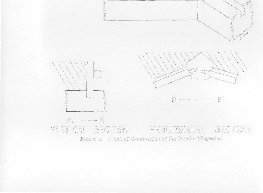

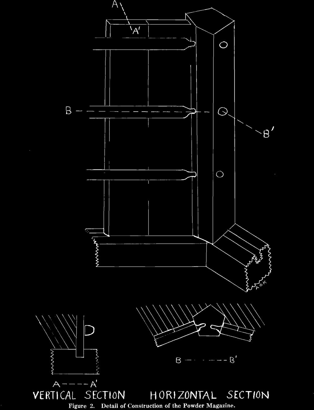
5 B A A' VERTICAL SECTION HORIZONTAL SECTION Figure 2. Detail of Construction of the Powder Magazine.


6 Site of Fort Washington 133 magazine was located. But the position of the rest of the Fort, i.e. in which direction it faced, can be deduced only from indirect evidence. It will be observed that the powder magazine was situated with its long side parallel to the side of the barracks and therefore at right angles to the south line of the Fort. To find the bearing or direction or azimuth of the front line of the Fort one need only rotate the drawing from the McHenry Papers so that the long side of the powder magazine on the drawing coincides with the direction of the long side of the powder magazine in the ground. Since the latter lay at a bearing of North 30 21' West the front face of the Fort must have been at right angles to it, or at a bearing of North 59 39' East. This is confirmed within the limits of acceptable accuracy by the official drawing of Fort Washington in the National Archives where the bearing or direction of the front row of barracks is specifically recorded as North 59 16' East. But to be certain of the exact location of Fort Washington all the conflicting testimony concerning it must be reconciled or explained. As far as can be determined there is universal agreement as to the site with one single exception, namely the small part of Daniel Drake's total evidence which claimed that the southeast blockhouse was on property that he had bought. His house, which is still standing as the Syrian Maronite Roman Catholic Church at 429 East Third Street, is at the very eastern edge of what is known in the Hamilton County Deed-books and Plat-books as the "U. S. Subdivision." Exactly when the United States acquired title to the "Military Reservation," if it ever actually did, once the patent to John Cleves Symmes had been granted, and how large an area it encompassed, is not clear. For example the Mansfield Survey, made upon order of the Federal government, specifies 15 acres, whereas the Town of Cincinnati claimed it was only 13 acres. Much information about the area and about some of the early settlers and their activities appear in the voluminous records, occupying 45 large ledger pages (page 263 through page 308 inclusive) of fine script in the case of The Heirs of Josiah Harmar, Deceased, vs. George Morris and David Gwynne, a Suit for Ejectment, heard the 28th of December, 1829, at Columbus, Ohio, in the United States Circuit Court, Ohio District, before Justices John McClean and John W. Campbell, and a jury. The volume


 and the digging of a cellar for General St. Clair somewhere north of Front Street and west of Lawrence Street.")
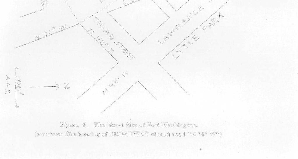
7 134 The Quarterly Bulletin of "Complete Record" containing this case is currently in Cincinnati in the files of the Circuit Court. The suit was the last phase of litigation started in 1809 against Ethan Stone in the Common Pleas Court, where he lost. The judgment against him was not satisfied until the sheriff sold some of his property at auction, where it was picked up by George Morris. David Gwynne got into the case by reason of having married the widow of John Piatt who had been Stone's partner in some other real estate deals. The sworn statement of John Cleves Symmes (taken in 1809 but read into the evidence) declares: "In the fall of 1789 Major John Doughty arrived... and laid the foundations of Fort Washington... Early in 1790, at the request of many officers of the Garrison... I was induced to lay out lots of 60 square rods each lying between Fort Washington and the Parade on the west and Deer Creek on the east." The actual surveying, it appears, was done by Israel Ludlow, and his plat, dated 1790, was registered as "In the Eastern Part of Cincinnati." It has the notation that the "course of the streets and lines running from the River was North 44 West," and appears on page 483 of Deed-book W-2 in the office of the Recorder of Hamilton County. This plat is shown in Figure 3. Many officers bought these lots from John Cleves Symmes, including General Harmar, Captain Pratt, Captain Strong, Doctor Allison, and General St. Clair. There is sworn testimony to flourishing gardens, crops of corn in 1791, the erecting of fences, the construction of a summer house for General Harmar (50 yards west of Lawrence St.) and the digging of a cellar for General St. Clair somewhere north of Front Street and west of Lawrence Street. General Wilkinson ordered "some of the fences thrown down in order to extend the ground for the exercise of the troops." General St. Clair ordered "prostrated" some of the "improvements" of General Harmar. One can be sure of only three landmarks: one was the house of Major Ruffin on the northeast corner of Front and Lawrence Street, another was Lawrence Street itself, and the last is Third Street. In regard to Third Street, the Reverend O. M. Spencer, on page 36 of his book already cited, has this description as of 1794: "A narrow road leading from Columbia to Cincinnati, just wide enough for the passage of a wagon, which, winding round the point of the hill above Deer Creek descended... and crossing that creek...


8 JOO Figure 3. Official Plat, "In the Eastern Part of Cincinnati" by Israel Ludlow (1790) bearing the notation "The Course of the streets and lines from the river N 44 W." Major Ruffin's house added.

![enclosed in a handsome paling?] entered the Town.](/docs-images/84/89368274/images/9-1.jpg "\" Since Israel Ludlow could not possibly have surveyed, and John Cleves Symmes could not possibly have sold, any ground on which the Fort itself stood,")


![] and adjoining the said second street to 12 rods from east to west, and on the east bounded by the lands of Governor St. Clair.](/docs-images/84/89368274/images/9-5.jpg "The other four lots, being part of the 8 lots aforesaid, are butted and bounded as follows: southward by the north side of the second street, 12 rods")
![wide on said street including the two lots on the east bounded by the first street running northwardly from the Ohio [present Lawrence Street] on the](/docs-images/84/89368274/images/9-6.jpg "east side of Fort Washington [reservation?")
![] adjoining said street 20 rods from north to south; on the north by the south side of the Third Street from the Ohio River, adjoining said Third Street](/docs-images/84/89368274/images/9-7.jpg "for 12 rods east and west, the said 4 lots being an oblong square of 12 by 20 rods from street to street lying eastwardly from Fort Washington.")
9 136 The Quarterly Bulletin ascending gradually its western bank, led along the ground now Symmes Street [the old name for Third Street east of Ludlow Street] directly toward Fort Washington, and diverging at the intersection [sic] of Lawrence Street to the right and left of the Fort [and the Parade enclosed in a handsome paling?] entered the Town." Since Israel Ludlow could not possibly have surveyed, and John Cleves Symmes could not possibly have sold, any ground on which the Fort itself stood, it is obvious, and should be indisputable, that the Fort must have been located outside the Ludlow 1790 plat. On May 6, 1791 Symmes sold to Josiah Harmar, Brigadier- General in the Army of the United States, 8 lots, each 60 square rods. This deed was confirmed over and over again in the several law-suits heard between 1809 and Unfortunately the numbers of the lots were not given so that their location must be deduced from the description in the deed, which was: "bounding on the south side on Front or River Street in the said Town, lying directly in front of Fort Washington, being 12 rods wide on said street, including two lots, and extending northwards from said Front St 20 rods to the south side of the second street from the Ohio [present Pearl St.] and adjoining the said second street to 12 rods from east to west, and on the east bounded by the lands of Governor St. Clair. The other four lots, being part of the 8 lots aforesaid, are butted and bounded as follows: southward by the north side of the second street, 12 rods wide on said street including the two lots on the east bounded by the first street running northwardly from the Ohio [present Lawrence Street] on the east side of Fort Washington [reservation?] adjoining said street 20 rods from north to south; on the north by the south side of the Third Street from the Ohio River, adjoining said Third Street for 12 rods east and west, the said 4 lots being an oblong square of 12 by 20 rods from street to street lying eastwardly from Fort Washington." The best that can be made out of this deed is that the four "lower lots" were numbers 1, 2, 23, and 24 (with General St. Clair owning Lots 3, 4, 21, and 22) and that Harmar's "upper lots" were numbers 27, 28, 45, and 46. (Figure 3.) Throughout the trial most of the controversy as to just where the Fort stood came about in order to interpret the significant words: "lying directly in front of Fort Washington."


10 Site of Fort Washington 137 There is not space here to describe the many legal ramifications, which included such things as Nicholas Longworth's statement that it was Symmes' practice to sell lots even before he had title to them, or that Symmes' title to these lots was confirmed only in 1794 when "General Harmar was away in the service of his country," or that the first suit by General Harmar was abated by his death and the second suit by reason of his son's being under age 21, or that General St. Clair sold Lots 1 through 24 to John Fricker who was killed in the Indian Wars and "his heirs could not locate the town of Losantiville in order to claim the property." To satisfy a judgment against John Cleves Symmes all his property "east of Broadway" was sold at public auction, and it was "cried down" to Ethan Stone in February, But just who owned these lands just east of Broadway was apparently not well established. Much of it was considered "publick," and the Ordinances of the Town of Cincinnati, under the date of 27 October 1804, contain the following resolution passed: "to petition for the fee of the Thirteen Acres now occupied by the Garrison and other Publick Buildings, and should Congress conceive this incompatible with their former donations of lands, that the ground lying north of a street running from the stone house of Daniel Symmes [Third St.] be granted in trust to the Corporation for the purpose of erecting an Academy, and that the land lying south of said street be granted to Jeremiah Hunt and Ethan Stone... and [the Corporation] shall grant to said Hunt and Stone a deed for such part thereof that lies south of said street on their paying the value thereof." The outcome of this petition is not known. What is now Arch Street was for a long time called School St., and the Guilford School is, of course, just north of it, and further research may reveal that this part of the "publick" land was set aside for educational purposes. But it would appear that Ethan Stone was trying to protect his title. That this land never became legally his is indicated by an entry on page 481 of Deed-book W-2 in the Recorder's Office, dated July 20, 1816, to the effect that he returned to numerous individuals (Daniel Drake not being included), moneys they had given him for lots to which he had asserted possession by reason of the sale in 1803 by the Sheriff, James Smith, as recorded in Deed-book L-l, page 446. The releases that followed on this entry are referred to frequently in the course of the 1829 law-suit and formed part of the charge to the jury.


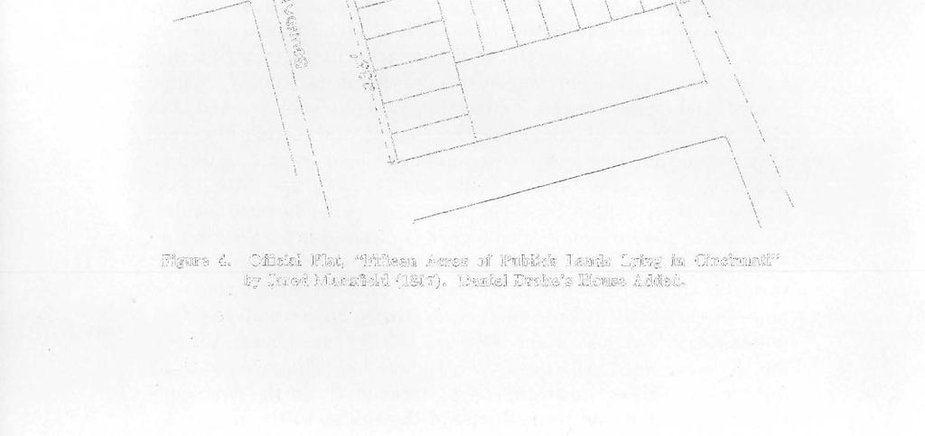

11 Figure 4. Official Plat, "Fifteen Acres of Publick Lands Lying in Cincinnati" by Jared Mansfield (1807). Daniel Drake's House Added.


12 Site of Fort Washington 139 In 1807 Jared Mansfield, in behalf of the U. S. Government, made a survey of the "Fifteen Acres of Publick Land Lying in Cincinnati." This survey is shown in Figure 4, and all testimony, measurements, and even an Ordinance of the Town of Cincinnati in 1814 indicate that the eastern edge of Ludlow Street is the eastern boundary of this tract. The Fort itself is not shown at all. This makes for a very strong presumption that by 1806 the buildings had been completely dismantled, leaving no vestige that a surveyor could use for a reference point. Evidence was adduced over and over again that the Fort faced generally southward, between Broadway and Ludlow Street. The defense tried in vain to get David Lewis to say that the southwest and northwest blockhouses were on the line of Broadway. William Orcutt swore that the southeast blockhouse was on "Drake's Corner," meaning Third and Ludlow. He was not asked to specify which of the four corners involved he meant, but there is nothing to show that it was not the northwest corner. Defense admitted that on May 31, 1816, the Supreme Court of the State of Ohio had ruled that Harmar's Heirs had title to certain lots bounded on the east by the first street running northward from the river on the east side of Fort Washington to a width of 12 rods and bounded on the north by the south side of Third Street, but Ethan Stone's affidavit specified that he was "not confessing or acknowledging all or any of the matters in the said Bill to be true." Thomas Henderson, surveyor for Hamilton County from 1807 to 1814 and then Recorder of Hamilton County, testified that in 1811 a "disturbance" arose in relation to the commons or esplanade laid out by Judge Symmes. His plan, made by Israel Ludlow, showing Lots numbered 1 through 57, was certified and made a matter of record. In the argument plantiff said that this plat of Israel Ludlow's was accepted by everyone except Ethan Stone; the defendant's objection to this and the introduction of the plat as evidence was overruled. Henderson continued that "there were no streets between Lawrence and Broadway prior to 1807." He further testified that "The U. S. Survey (Mansfield's) did 'interfere' with the lots laid out by Judge Symmes." Nicholas Longworth stated that Lot #24 bounded on the Reservation, i.e. Ludlow Street. Christopher Cary testified that in 1807 he was erecting a fence for Ethan Stone on a lot through the western part of which ran Ludlow Street (?Lot #46) and that Jesse Hunt and

, and then combining them correctly at two established points. Figure 5 presents this composite map.")

13 140 The Quarterly Bulletin David Ziegler warned him there would be a law-suit, as the land belonged to General Harmar. Griffith Yeatman felt that the reason General St. Clair never built his house on the cellar he had dug was that St. Clair feared there was a possibility that his house might come to lie within the Reservation. John Riddle confirmed this. What was meant by "interference" can be readily seen if the Mansfield Survey and the Ludlow Survey are drawn to the same scale and oriented with the streets running correctly in relation to true north as each of these surveyors recorded them (and as they run now), and then combining them correctly at two established points. Figure 5 presents this composite map. Jesse Hunt testified that he had arrived in Cincinnati in March 1789, that from 1801 or 1802 until 1821 he was General Harmar's agent, and that "two lots of Harmar's were lost by the Garrison Reservation." He was then asked this question: "Did you understand during your agency for Harmar's Heirs that but for the interference of the Garrison reservation, Harmar's upper block could have enclosed the ground on a part of which Dr. Drake's house now stands?" The answer was: "I did suppose that the upper block would come somewhere near where Dr. Drake's house now stands." But probably the most startling sworn statement was that of Joseph Gest. Under cross-examination he admitted, and it was borne out by other testimony, that he had made the survey of the disputed lands, not independently, but from the description given him by Ethan Stone! In addition to that, it has been known for years that some of Gest's measurements contain an error due to his use of a nonstandard rule. And yet Daniel Drake explained that he knew he was right about the site of Fort Washington on the basis of the plat made by Gest. The court refused to admit Drake's map in evidence and insisted that he personally testify. His description of Fort Washington was accurate as to the direction in which it faced, but in answer to the question: "What would be the location of four lots, the calls of which were 'lying directly in front of Fort Washington'?" he replied only that they would lie west of Ludlow Street, making no mention of Third Street. Drake's statement that the front of the Fort was on Front Street was an obvious slip of the tongue. If one includes the


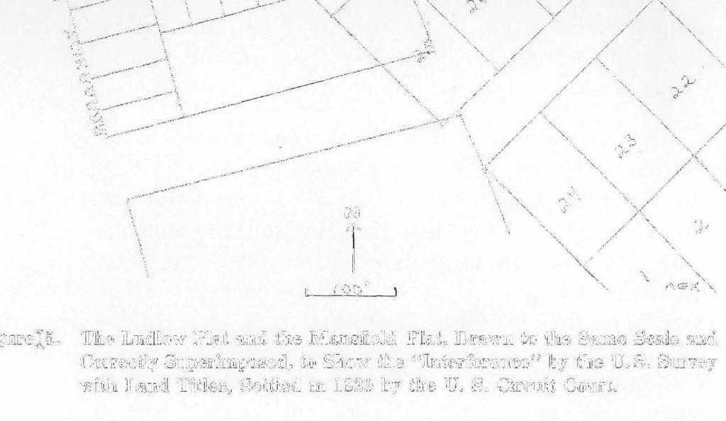

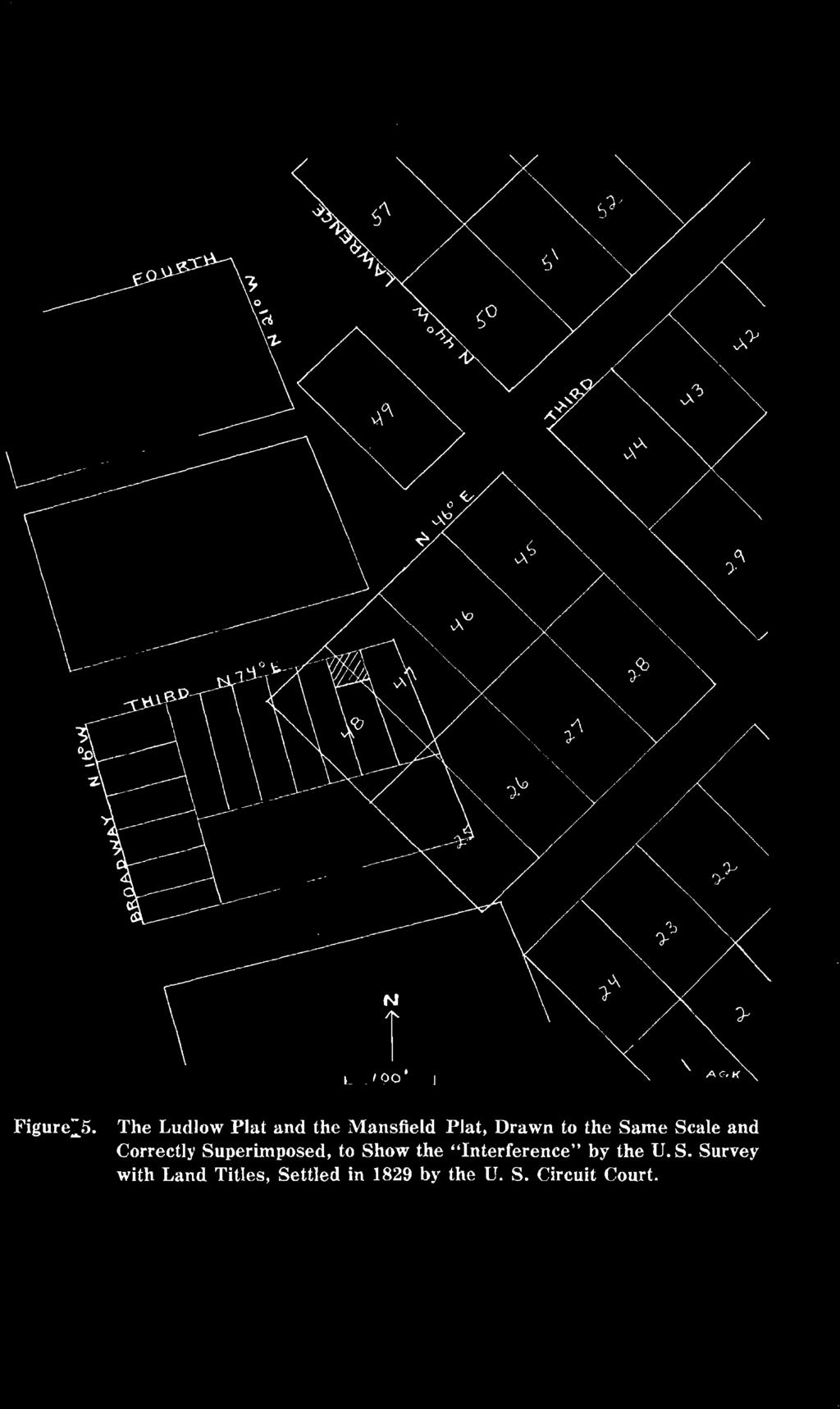
14 t I0O I Figure^5. The Ludlow Plat and the Mansfield Plat, Drawn to the Same Scale and Correctly Superimposed, to Show the "Interference" by the U. S. Survey with Land Titles, Settled in 1829 by the U. S. Circuit Court.


15 142 The Quarterly Bulletin Parade, as almost everyone did, his map shows the front of the Fort on Congress Street (now Pearl Street). Or it may have been a slip of the pen of the Clerk of Court. The entire record shows numerous words crossed out, others duplicated and not crossed out, others very obviously omitted, and there are many interlineations and additions, all in the same handwriting but some in different ink. The record, naturally, was reviewed and corrected, but in a phrase such as "south front was on the south side of Front Street" the error must have gone undetected. When Daniel Drake placed the Fort straddling Third Street, part of the Fort, as contrasted with the Military Reservation, was on his property. Whether due to faulty memory, or wishful thinking, or independent reconstruction of fragments of evidence he had heard, or because, like Joseph Gest, he believed Ethan Stone, the net effect was to exclude his property from the disputed "lands lying directly in front of the Garrison." However, the jury found for the plaintiff in accordance with the charge of the court. This reaffirmed the validity of the deed from Symmes to Harmar for the eight lots indicated on the Ludlow 1790 survey and described as lying directly in front of Fort Washington. This places Fort Washington directly behind the disputed lots, and officially rejects the site shown by Drake in 1815, restated by Jones in 1902, and inscribed on the monument at Third Street and Ludlow Street. The recent discovery of the powder magazine proves the correctness of the verdict of the jury and the error of Daniel Drake. Apparently also in error is the compromise location offered by Richard Knopf, Raymond S. Baby, and Dwight L. Smith in the January 1953 Bulletin of the Historical and Philosophical Society (vol. 11, page 3). Their text states: "the 1789 plan shows the fort was constructed on an angle (??) the front facing west of south," but their own figure 3 shows it facing east of south. They title their figure 3 as "Map of 1789 showing N 59 16' E construction line" but in their text and in their figure 4 they speak of a "N 59 16' E construction angle." By these contradictory terms they are probably referring to what the original drawing shows as a bearing or direction of the line under which it is written, a universal surveyors' practice in use for at least 200 years. They use this interpretation of the bearing N 59 16' E, calling it the north-


 and also in the copy submitted to the court in 1829, whereas the very same map in the Hamilton County Deedbook (W-2, page 483) entered in 1808, has the notation correctly, as N 16 W.")

16 Site of Fort Washington 143 south axis of the fort, to explain the "north" that appears in the 1792 (McHenry Papers) drawing of Fort Washington shown in their Figure 2. This "north" is the sole point of argument, and admittedly is a little puzzling. On the other hand, as a representation of north it is very unusual and looks as if it might have been added as an afterthought. If General Harmar or General St. Clair felt that the relationship of the Fort to the terrain or the river or to other artifactual elements such as a street were important, there would most certainly have been other indications of orientation. Could the original draftsman have been confused by the similarity of the two triangular extensions and put the symbol for "north" on the west arm, without the error being detected at the time? An example of how this could happen as a draftsman's error is the fact that the Mansfield survey of 1807 shows Broadway correctly but has "N 11 W" on the copy used by the Cincinnati City Engineer (1819) and also in the copy submitted to the court in 1829, whereas the very same map in the Hamilton County Deedbook (W-2, page 483) entered in 1808, has the notation correctly, as N 16 W. In any case, all other evidence as to the way the Fort faced is so overwhelmingly great that the dependability of that particular compass reading can be doubted. Their Figure 4 shows the long side of the powder magazine lying at a bearing of North 30 East, whereas actually it was found lying at a bearing of North 30 West, a disorientation, again, of exactly 90 degrees. Further, they show Broadway running true north, whereas it still runs, as Israel Ludlow stated he intended it, 16 west of north. They have placed the powder magazine 170 feet from Broadway, whereas it actually was found 34 feet farther east than that. Correcting their error, they would have the northeast blockhouse on the other side of Ludlow Street, well outside the Military Reservation, and the southeast blockhouse in the Ludlow Street gully. The triangular extension to the north would then wipe out Lot #49 which Symmes sold to Captain Pratt. The "handsome paling" which is supposed to have surrounded the Fort would block Lawrence Street, over which Oliver M. Spencer drove his wagon in 1794, and would encroach on the property of Dr. Allison. It is hardly fair to rob Dr. Allison to pay Dr. Drake. One more site of Fort Washington must be mentioned. The Historical and Philosophical Society has in its possession a map of


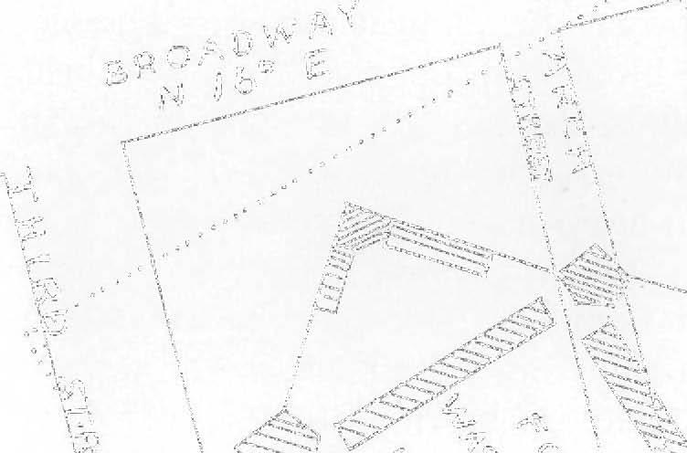


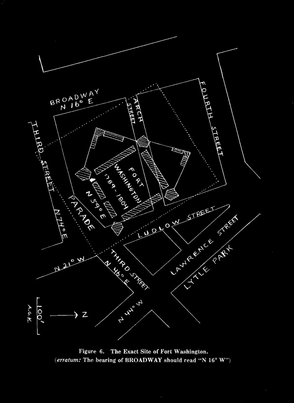
17 Figure 6. The Exact Site of Fort Washington. {erratum: The bearing of BROADWAY should read "N 16 W")


 of the Hamilton County records, and the validity of the sale of the lots has been")


18 Site of Fort Washington 145 Cincinnati and Fort Washington. Unfortunately, complete identification of the map and its origin has not yet been made. Informally called "the St. Clair Map" it deals with "the military lines as drawn by General St. Clair's order in 1792," and from the names and military ranks of the property owners shown, it can be dated with assurance as of The Ludlow Survey is correctly incorporated, as well as the "second bank" and the gully, and although it is a crude map, obviously not that of a professional surveyor, it has every indication of being an authentic military sketch. It shows Fort Washington with the southwest blockhouse exactly where the powder magazine was found, and the front of the Fort at a bearing of approximately North 65 East. Considering that this is a sketch rather than a draftsman's plat, it may be taken as very strong supporting evidence. SUMMARY Figure 6 illustrates the exact site of Fort Washington, built in With two minor exceptions which are discussed in the text, this site fits every known description and drawing of the Fort, together with every known scrap of ancillary evidence. The facts to support this site consist of the following: 1. The Fort must necessarily have stood outside the limits of the 57 lots surveyed by Israel Ludlow in 1790 and sold by John Cleves Symmes. The plat is recorded in Deed-book I, page 458 (old page 628) of the Hamilton County records, and the validity of the sale of the lots has been upheld by the courts over and over again. 2. The recent discovery of a structure, identified as the powder magazine, makes possible the pin-pointing of the southwest blockhouse behind which it had been dug, according to coeval evidence and the plan of Fort Washington of 1792 found in the McHenry papers. This is a spot 49 feet from the north line of Third Street and 204 feet from the east line of Broadway. 3. The direction in which the Fort faced is determined by evidence from independent sources: (a) The south line of the Fort was at right angles to the long side of the powder magazine, or at right angles to a carefully determined bearing of North 30 21' West, making the line of the front of the Fort, North 59 39' East, (b) The recorded bearing of the front of the Fort, as given in the official plat of 1789 in the National Archives, is North 59 16' East,
 east of true south. 4.")


19 146 The Quarterly Bulletin essentially the same, (c) Without exception every one of the many recorded descriptions of the Fort confirms this direction, that is, that the Fort faced a little (30 ) east of true south. 4. The Fort, the westward triangular addition and the northward triangular addition to the Fort, as well as the 80 feet of "Parade" in front of the Fort must have been within the Mansfield Survey of the U. S. Government Military Reservation. It is hardly possible that the parade could have included the Ludlow Street gully which goes southward from Third Street. A corollary suggestion is made that as no landmark representing the Fort appears on this survey of 1807 (the year that Ludlow Street came into existence) it is likely that every vestige of the Fort had been obliterated before that year. 5. The various other sites suggested heretofore (with the exception of the still unidentified "St. Clair" map) were based on the testimony of Daniel Drake that his property included a portion of the Fort rather than being part of the disputed land "lying directly in front of the Fort." The background of this controversial testimony is discussed in detail, with strong implications that it was in error.
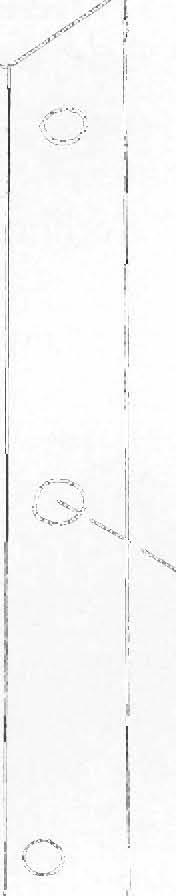
A section of a corner post, two of the horizontal cross members, and a piece of planking in their original positions. Note the doweled joints and the
 A section of a corner post, two of the horizontal cross members, and a piece of planking in their original positions. Note the doweled joints and the angle at which the corner post is cut. The piece of
Circuit Court, D. Iowa
 YesWeScan: The FEDERAL CASES Case No. 1,142. [5 Dill. 549.] 1 BAYLISS V. POTTAWATTAMIE COUNTY. Circuit Court, D. Iowa. 1878. DEDICATION OF PUBLIC SQUARE IOWA STATUTE ESTOPPEL. The public square in the
Old Sandy Baptist Church Graveyard
 Old Sandy Baptist Church Graveyard By Dave Hallemann This original church cemetery is located in T41 R4 Survey 2018 in what was at one time called the Upper Sandy Settlement off Highway 21. It was visited
Parts one and two of the transcriptions of the documents within the Elena Gallegos Land Grant papers
 The Elena Gallegos Land Grant Part III by Henrietta M. Christmas and Angela Lewis Parts one and two of the transcriptions of the documents within the Elena Gallegos Land Grant papers can be found in the
Fallacies of the Warren Commission Solution
 Fallacies of the Warren Commission Solution by Thomas Purvis from his unpublished work, There Is No Magic (published with special permission) Altered Evidence By utilizing the services of a Registered
Our Community Service. by William A. "Steve" Stephens. [Portions Taken from my report to the members of the Moffat Cemetery Assn.]
![Our Community Service. by William A. Steve Stephens. [Portions Taken from my report to the members of the Moffat Cemetery Assn.]](/thumbs/95/125400252.jpg "Our Community Service. by William A. Steve Stephens. [Portions Taken from my report to the members of the Moffat Cemetery Assn.]") Our Community Service by William A. "Steve" Stephens [Portions Taken from my report to the members of the Moffat Cemetery Assn.] We begin with some background. We became involved in the cemetery shortly
Our Community Service by William A. "Steve" Stephens [Portions Taken from my report to the members of the Moffat Cemetery Assn.] We begin with some background. We became involved in the cemetery shortly
IN COURT OF APPEALS DECISION DATED AND RELEASED NOTICE. August 19, No STAN SMITH, INC., PLAINTIFF-APPELLANT,
 COURT OF APPEALS DECISION DATED AND RELEASED August 19, 1997 A party may file with the Supreme Court a petition to review an adverse decision by the Court of Appeals. See 808.10 and RULE 809.62, STATS.
Zeroing in on Christopher Gist s cabin site
 Zeroing in on Christopher Gist s cabin site By Lannie Dietle Christopher Gist looms large in regional and national history for the important role he played in the years leading up to the French and Indian
R E S O L U T I O N. B. Development Data Summary:
 R E S O L U T I O N WHEREAS, the Prince George s County Planning Board has reviewed Certification of Nonconforming Use Application No. CNU-45423-2016 requesting certification of a nonconforming use for
Sara Copeland, AICP, Community Development Director. Vacating Right-of-Way in the Armour Road Redevelopment Area
 MEMORANDUM TO: FROM: Mayor and City Council City Administrator Sara Copeland, AICP, Community Development Director DATE: April 4, 2017 RE: Vacating Right-of-Way in the Armour Road Redevelopment Area As
STATE OF OHIO ERIC SMITH
 [Cite as State v. Smith, 2010-Ohio-4006.] Court of Appeals of Ohio EIGHTH APPELLATE DISTRICT COUNTY OF CUYAHOGA JOURNAL ENTRY AND OPINION No. 93593 STATE OF OHIO PLAINTIFF-APPELLEE vs. ERIC SMITH DEFENDANT-APPELLANT
Communications. THE RIBCHESTER "TEMPLE."
 THE RIBCHESTER "TEMPLE." TSJINETY-TWO years ago, in July, 1811, a J- ^ Roman inscription was discovered at Ribchester, which, though fragmentary and in part obscure, provides evidence that early in the
STATE OF LOUISIANA COURT OF APPEAL, THIRD CIRCUIT ************
 STATE OF LOUISIANA COURT OF APPEAL, THIRD CIRCUIT 04-1399 WILLIAM T. LOWERY, SR. VERSUS GREGORY ALLEN HERBERT, ET AL ************ APPEAL FROM THE TWENTY-SEVENTH JUDICIAL DISTRICT COURT, PARISH OF ST. LANDRY,
METES AND BOUNDS DESCRIPTION OF A ACRE TRACT J. H. JONES SURVEY, A-26 BRYAN, BRAZOS COUNTY, TEXAS
 METES AND BOUNDS DESCRIPTION OF A 0.563 ACRE TRACT J. H. JONES SURVEY, A-26 BRYAN, BRAZOS COUNTY, TEXAS METES AND BOUNDS DESCRIPTION OF ALL THAT CERTAIN TRACT OF LAND LYING AND BEING SITUATED IN THE J.
Methodist Episcopal Union Church records
 33 Finding aid prepared by the Historical Society of Pennsylvania's Hidden Collections Initiative for Pennsylvania Small Archival Repositories using data provided by the Historical Society of the Eastern
S08A1608. WALKER et al. v. SAPELO ISLAND HERITAGE. AUTHORITY et al. In 2006, Jonathan Walker and Linda Woods, on behalf of themselves
 Final Copy 285 Ga. 194 S08A1608. WALKER et al. v. SAPELO ISLAND HERITAGE AUTHORITY et al. Hines, Justice. In 2006, Jonathan Walker and Linda Woods, on behalf of themselves and the similarly situated heirs
Glade District, Oglethorpe County, Georgia Location: end of Pea Ridge Road, N W
 Glade District, Oglethorpe County, Georgia Location: end of Pea Ridge Road, N 34 00 05 W 83 02 40 Research and narrative by descendants: Mr. Glenn M. Paul and Dr. Michael M. Black Buried in this cemetery
MINUTES PLANNING BOARD OF THE BOROUGH OF MADISON REGULAR MEETING DECEMBER 1, 2015
 MINUTES PLANNING BOARD OF THE BOROUGH OF MADISON REGULAR MEETING DECEMBER 1, 2015 A regular meeting of the of the Borough of Madison was held on the 1st day of December 2015 at 7:30 P.M., in the Court
Genealogy and NORTH CAROLINA Counties
 1 Genealogy and NORTH CAROLINA Counties An ancestor blessed with longevity could have been born in Rowan County in 1753. married in Burke County in 1778, fathered children in the counties of Burke and
Mini-Unit Integrating ELA and Social Studies With Maps and Primary Source Documents
 Mini-Unit Integrating ELA and Social Studies With Maps and Primary Source Documents This picture, The Trail of Tears, was painted by Robert Lindneux in 1942. What do you see? Be specific. Trail of Tears
ORDINANCE NO , and of Chapter 51 of the Dallas City
 ORDINANCE NO. 16439 12/11/79 An Ordinance amending CHAPTER 51, "COMPREHENSIVE GENERAL ZONING ORDINANCE," of the Dallas City Code, as amended, by permitting the following described property, to-wit: Being
From the Archives: UTAH STATE HISTORICAL SOCIETY 300 Rio Grande Salt Lake City, UT (801)
") From the Archives: Sources 145 From the Archives: Sources UTAH STATE HISTORICAL SOCIETY 300 Rio Grande Salt Lake City, UT 84101-1182 (801) 533-3535 HOURS OF OPERATION 10 a.m.-5 p.m., Monday through Friday
From the Archives: Sources 145 From the Archives: Sources UTAH STATE HISTORICAL SOCIETY 300 Rio Grande Salt Lake City, UT 84101-1182 (801) 533-3535 HOURS OF OPERATION 10 a.m.-5 p.m., Monday through Friday
"Father of Brownwood"
 from; THE PROMISED LAND A HISTORY OF BROWN COUNTY, TEXAS by James C. White "Father of Brownwood" GREENLEAF FISK is a name that is engraved indelibly upon the tablets of Brown County's history, and is known
PPS RECORDS FOR 125 HOPE STREET PLAT 17, LOT 602
 PPS Records for 125 Hope Street Page 1 NOTES PPS RECORDS FOR 125 HOPE STREET PLAT 17, LOT 602 JOSEPH S. COOKE HOUSE Built 1819 at the corner of Hope and Power Streets; Moved to this location in 1885 by
Bible Christian Cemetery
 RESEARCH REPORT HTG-14-121 Bible Christian Cemetery 39 Columbus Road West Oshawa, Ontario Prepared for Heritage Oshawa Prepared by M. Cole August 2012 31 1.0 Introduction 1.1 Purpose of Report 3 1.2 Legislative
Cincinnati Doctors Before Daniel Drake, '
 Cincinnati Doctors Before Daniel Drake, 1788-1807' by ARTHUR G. KING, M.D. In a mystical way, perhaps, the heritage of Cincinnati as a medical center may have been foreshadowed by the exposure to the Aesculapian
The General William Henry Harrison Trail through Portions of Vermillion County and Warren County, Indiana Written 11 October 2015 by Curtis L.
 The General William Henry Harrison Trail through Portions of Vermillion County and Warren County, Indiana Written 11 October 2015 by Curtis L. Older Five Probable Points Along the Harrison Trail, including
Denny-Frye family papers,
 Overview of the Collection Creator Denny-Frye family Title Denny-Frye family papers Dates 1853-1915 (inclusive) 1853 1915 Quantity.28 cubic ft (113 items) Collection Number 0096 (Accession No. 0096-001)
2008R07557 * R * I llllll lllll lllll lllll lllllll Ill lllll lllll lllll lllll llll llllll llll llll. Recording Cover Sheet
 Recording Cover Sheet ORDINANCE NO. 2007-09-099 AN ORDINANCE VACATING A PORTION OF COLER AVENUE BETWEEN PARK STREET AND CHURCH STREET and PLAT MAP SHOWING PUBLIC RIGHT-OF-WAY VACATED I llllll lllll lllll
Kemp et al. vs. Hull Copper Co., DB 542 Finding Aid Sharlot Hall Museum Archives
 Kemp et al. vs. Hull Copper Co., 1906-1918 DB 542 Finding Aid Sharlot Hall Museum Archives Description The Papers of Kemp et al. vs. Hull Copper Company is a collection of legal papers of a landmark lawsuit
RESCHEDULED REGULAR MEETING OF THE BOARD OF DIRECTORS OF THE CITY OF TEXARKANA, ARKANSAS SEPTEMBER 3, 2002
 RESCHEDULED REGULAR MEETING OF THE BOARD OF DIRECTORS OF THE CITY OF TEXARKANA, ARKANSAS SEPTEMBER 3, 2002 MEMBERS PRESENT: The Board of Directors of the City of Texarkana, Arkansas, convened in rescheduled
2009R23684 * R * Recording Cover Sheet
 Recording Cover Sheet ORDINANCE NO. 2009-06-070 AN ORDINANCE VACATING COLLEGE COURT MARYLAND DRIVE AND LINCOLN AVENUE) (BETWEEN (PLAT MAP SHOWING PUBLIC RIGHT-OF-WAY VACATED ATTACHED) I llllll lllll lllll
UNITED STATES DISTRICT COURT NORTHERN DISTRICT OF ILLINOIS EASTERN DIVISION
 Case: 1:16-cv-02912 Document #: 35 Filed: 04/18/17 Page 1 of 7 PageID #:499 UNITED STATES DISTRICT COURT NORTHERN DISTRICT OF ILLINOIS EASTERN DIVISION COLIN COLLETTE, ) ) Plaintiff, ) ) 16 C 2912 v. )
HENRY¹ OF HINGHAM Sixth Generation
 HENRY¹ OF HINGHAM Sixth Generation No. 417 NAME: Stout⁶ Chamberlin Father: Richard⁵ Chamberlin (No. 218) [John⁴ (Henry³, John², Henry¹) and Rebecca (Morris) Chamberlin] Mother: Mary Stout Born: 1 May 1757,
THE LATE GREAT PUGET SOUND MERIDIAN. Washington State s Own Principal Meridian. by Denny DeMeyer
 THE LATE GREAT PUGET SOUND MERIDIAN. Washington State s Own Principal Meridian by Denny DeMeyer Pausing briefly in a clearing in the forest while ascending a ridge just south of Bellingham, the surveyors
CITY OF KENT BOARD OF ZONING APPEALS PUBLIC HEARING & BUSINESS MEETING April 18, Dave Mail Paul Sellman Jona Burton Benjamin Tipton
 CITY OF KENT BOARD OF ZONING APPEALS PUBLIC HEARING & BUSINESS MEETING MEMBERS PRESENT: STAFF PRESENT: Elizabeth Howard Dave Mail Paul Sellman Jona Burton Benjamin Tipton Bridget Susel, Community Development
Copyright 2016 by Gary Boden and the Exeter Historical Association
 The Horn Heap Among the landmarks of Exeter, there s a nearly forgotten one with a strange alliterative name. It s called the Horn Heap and its story goes back to the very earliest days of the Rhode Island
IN THE HIGH COURT OF JUSTICE (CIVIL} A.D FREDERICK PROSPERE. and. 1. THOMAS WALCOTT, Executor of Joseph Felecien, deceased;
 l~ 9--~,, J ~-t) V-t_ L1>\_/ \~ C ()l< j.t: v'. SAINT LUCIA #043 IN THE HIGH COURT OF JUSTICE (CIVIL} A.D. 1994 Suit No. 488 of 1991 BETWEEN: FREDERICK PROSPERE and 1. THOMAS WALCOTT, Executor of Joseph
Tarrant County. Civil War Veterans of Northeast Tarrant County. Edward Pompi Deason. Compiled by Michael Patterson
 Tarrant County TXGenWeb Barbara Knox and Rob Yoder, County Coordinators Copyright 2010-2012. All rights reserved. Civil War Veterans of Northeast Tarrant County Edward Pompi Deason Compiled by Michael
Boise City Planning & Zoning Commission Minutes August 4, 2014 Page 1
 Page 1 CVA14-00030 / SCOTT STEWART Location: 1493 W. Saint Patrick Street VARIANCE TO REDUCE THE STREET-SIDE SETBACK FROM 20 FEET TO APPROXIMATELY 2 FEET AND REDUCE THE REAR YARD SETBACK TO APPROXIMATELY
Document Based Question. Evaluate the changes in America ideology and policy towards American Indians between the time period of
 Document Based Question Evaluate the changes in America ideology and policy towards American Indians between the time period of 1763-1835. Document 1 The Royal Proclamation of 1763 King George And whereas
Dorcas, a Free Person of Color in Washington County *Note The spelling was not changed from the original records.
 Dorcas, a Free Person of Color in Washington County *Note The spelling was not changed from the original records. Christopher Taylor was one of the early settlers of Washington County, Tennessee. He was
2008 SURVEY OF INDIANA COUNTY SURVEYORS
 THE COUNTY SURVEYOR: 2008 SURVEY OF INDIANA COUNTY SURVEYORS 1. Are you a Registered Land Surveyor or Professional Engineer? a. REGISTERED LS b. PE c. BOTH d. NEITHER 2. Is your position as County Surveyor
1.2. What is said: propositions
 1.2. What is said: propositions 1.2.0. Overview In 1.1.5, we saw the close relation between two properties of a deductive inference: (i) it is a transition from premises to conclusion that is free of any
Court of Appeals of Ohio
 [Cite as State v. McMichael, 2012-Ohio-1343.] Court of Appeals of Ohio EIGHTH APPELLATE DISTRICT COUNTY OF CUYAHOGA JOURNAL ENTRY AND OPINION Nos. 96970 and 96971 STATE OF OHIO PLAINTIFF-APPELLEE vs. TREA
Southern Campaigns American Revolution Pension Statements & Rosters
 Southern Campaigns American Revolution Pension Statements & Rosters Pension application of James Withrow S7945 Transcribed by Will Graves f37nc rev'd 1/24/11 &2/18/18 [Methodology: Spelling, punctuation
RISING SUN, INDIANA STAMPLESS COVERS
 RISING SUN, INDIANA STAMPLESS COVERS Rising Sun was settled in 1813. The post office opened September 15, 1815. Larger in population than Indianapolis until the mid 1820's, Rising Sun was one of Indiana's
PRAIRIE GROVE CUMBERLAND PRESBYTERIAN CHURCH HISTORY
 The land now known as Washington County, Arkansas, was first home to Native American tribes such as the Osage and Cherokee. In 1817, this territory was part of Lovely s Purchase, named after Major William
Introduction and Transcription to the Andrew Woods Deerskin Booklet
 Introduction and Transcription to the Andrew Woods Deerskin Booklet Accreditation This deerskin covered booklet belonged to an Andrew Woods of Virginia, between 1759-1789, whose father had died in 1758.
Southern Campaigns American Revolution Pension Statements & Rosters
 Southern Campaigns American Revolution Pension Statements & Rosters Pension Application of Joshua Dinkins S3278 Transcribed by Jim Long Joshua Denkins or Dinkins Revolutionary War Pension File Service:
Ft. Smith National Historic Site Documentary Cedarville High School Environmental and Spatial Technology (EAST) Narrator/Voice-Over: Bailie Murphy
 Narrator/Voice-Over: Bailie Murphy") Narrator/Voice-Over: Bailie Murphy Student Created Music: Manuel Galdamez (AERIAL VIEW OF HISTORIC SITE) The Ft. Smith National Historic Site is located on the bank of the Arkansas River in downtown Ft.
Narrator/Voice-Over: Bailie Murphy Student Created Music: Manuel Galdamez (AERIAL VIEW OF HISTORIC SITE) The Ft. Smith National Historic Site is located on the bank of the Arkansas River in downtown Ft.
THE WELLINGTONS OF TRAPELO ROAD by Elizabeth Castner 1
 THE WELLINGTONS OF TRAPELO ROAD by Elizabeth Castner 1 Roger Wellington was in Watertown as early as 1636. He lived first in the eastern part of the town, his homestall being mostly in Mt. Auburn but was
Chapter 3. Alabama: Territory & State
 Chapter 3 Alabama: Territory & State Lesson 1 (page 71) 13 Colonies began to object the way the British king and Parliament made rules for them. France & Spain helped the colonies win the war. BrainPOP
Descendants of John Miller
 FIRST DRAFT OF 06/12/2003 Summary not to be relied upon as "primary documentation" SUMMARY OF ABSTRACT OF TITLE Utica Township, Clark Co., Indiana Tract 1 57 acres in Section 51 Tract 2-6.5 acres in Section
The Courthouse Mentioned in the Revelation on Zion
 The Courthouse Mentioned in the Revelation on Zion The Courthouse Mentioned in the Revelation on Zion Max H. Parkin In the summer of 1831 after the Prophet Joseph Smith and members of his party arrived
Ipperwash: General Historical Background
 1 Ipperwash: General Historical Background Joan Holmes & Associates, Inc. Sketch from Field Book of Surveyor M. Burwell, 1826. Native Peoples (circa, 1740) 2 The ancestors of the Kettle and Stony Point
J. NEILSON BARRY, portland, Oregon.
 A VALUABLE MANUSCRIPT WHICH MAY BE FOUND In 1852 there was a manuscript journal with an alleged ac-. count of a journey by four shipwrecked sailors from the Oregon coast to the Red River, and the following
MOUNDS IN VERMONT: PREHISTORIC OR HISTORIC?
 MOUNDS IN VERMONT: PREHISTORIC OR HISTORIC? WILLIAM A. HAVILAND University of Vermont Revised 1973 Vermont Archaeological Society Monograph Series: Number 2 Vermont Archaeological Society c/o Waterman
Mormon Trail, The. William Hill. Published by Utah State University Press. For additional information about this book
 Mormon Trail, The William Hill Published by Utah State University Press Hill, William. Mormon Trail, The: Yesterday and Today. Logan: Utah State University Press, 1996. Project MUSE., https://muse.jhu.edu/.
AGENDA ITEM COVER SHEET
 AGENDA ITEM COVER SHEET Use this form when submitting items for the Town Council Agenda PUBLIC HEARING No. 05 Meeting Date: August 15, 2017 Requesting Department: Planning Presenter(s): Shelly Mayo, Planner
Southern Campaigns American Revolution Pension Statements & Rosters
 Southern Campaigns American Revolution Pension Statements & Rosters Pension application of Ansel Fields (Field) W10021 Martha Fields f55nc Transcribed by Will Graves 12/22/08 rev'd 2/6/15 [Methodology:
a. The Annexation Area is adjacent to and contiguous to the existing boundaries ofthe City of Jeffersontown; and,
 CITY OF JEFFERSONTOWN JEFFERSON COUNTY, KENTUCKY ORDINANCE NO. 1341, SERIES 2016 AN ORDINANCE ANNEXING TO THE CITY OF JEFFERSONTOWN A CERTAIN TRACT OF LAND IN THE COUNTY OF JEFFERSON, ADJOINING THE PRESENT
sw 668PA485 CITY OF MONTICELLO n U y tqt ` PIATT COUNTY, ILLINOIS ORDINANCE NO
 sw 668PA485 STATE Qf ILLINOIS COUNWOF PIATT: 33S779 Filed r rocurd in d d C ounty CITY OF MONTICELLO 4.0. 116116n U y tqt ` Cto k Aa. m. PIATT COUNTY, ILLINOIS the L on and recor(wi in F3nij1 in ORDINANCE
FIRST CHRISTIAN CHURCH BOARD RESOLUTION TO MERGE
 [[The purpose of this resolution is to transfer the real property of Niles Congregational Church to Niles Discovery Church. This needs to be done at the final congregational meeting of Niles Congregational
BROWN, JOSEPH PAPERS,
 State of Tennessee Department of State Tennessee State Library and Archives 403 Seventh Avenue North Nashville, Tennessee 37243-0312 BROWN, JOSEPH PAPERS, 1772-1965 (THS Collection) Processed by: Gracia
This Newsletter marks the tenth All About Stout newsletter! To celebrate, can you find all 10 Tens in this Newsletter edition? Inside this Issue:
 Volume 4, Issue 2 June 2014 www.stoutconnection.org Inside this Issue: 1 Moody Memorial - Richard Stout 1 Find the 10 tens! 2 Stout Committee Information 2 Family Search Sources 3 June 2014 - Stout Reunion
Mormon Trail, The. William Hill. Published by Utah State University Press. For additional information about this book
 Mormon Trail, The William Hill Published by Utah State University Press Hill, William. Mormon Trail, The: Yesterday and Today. Logan: Utah State University Press, 1996. Project MUSE., https://muse.jhu.edu/.
William Peters. pg 1/16
 pg 1/16 William Peters No Picture Available Born: 1788 South Carolina Married: Mar 1810 to Rachael Bamberg Died: 1860 Lowndes Co., GA Parents: John Christopher Peters & Mary Unknown Pg 2/16 Article from
WHEREAS, the Alleghany County School Board is vested with title to certain real
 BOUNDARY LINE AGREEMENT BETWEEN FALLING SPRING PRESBYTERIAN CHURCH AND THE ALLEGHANY COUNTY SCHOOL BOARD Prepared by and return to: R.W. Vaught, 355 W. Main Street, Covington, VA 24426 (VSB #17376) Title
Ezekiel Chapters 40-42
 Ezekiel 40 1 Ezekiel Chapters 40-42 Chapter 40 1 In the twenty-fifth year of our captivity, at the beginning of the year, on the tenth day of the month, in the fourteenth year after the city was captured,
Sons of Abraham Synagogue
 HISTORIC RESOURCES 2013 City of Medicine Hat Sons of Abraham Synagogue Date of Construction 1912 Address 530-5 (Ottawa) Street SE Original Owner Elijah L. Becker Architect Elijah L. Becker Contractor Mat
NOTICES OF SHERIFF'S SALE
 Updated: 03/17/18 at 1:16 AM NOTICES OF SHERIFF'S SALE Date & Time of Sale: Wed, Oct 04, 2017 at 1:00 pm Sheriff Sale File number: 67-17-0072-SS Judgment to be Satisfied: $58,234.93 Cause Number: 67D01-1609-MF-000070
Why is the Treaty at Logstown in 1748 so important? What did it do?
 Student Worksheet A Shot in the Backwoods of Pennsylvania Sets the World Afire Worksheet 1: Focus Questions for "The Roots of Conflict" Instructions: Your group may answer these questions after the reading
Chapter 7: The Ark of the Covenant
 7 The Ark of the Covenant 195 Chapter 7: The Ark of the Covenant The average person would say that Moses and the Hebrews made and used the Ark of the Covenant as a way to talk and listen to God. This is
EHER 9194 Field to South of Sewage Works at Bures St Mary National Grid Ref: TL919333
 EHER 9194 Field to South of Sewage Works at Bures St Mary National Grid Ref: TL919333 Background Situated to the South of the Sewage works and North of a bend in the river Stour. The Tithe Award Map of
Wenatchee Indians Ask Justice 21
 WENATCHEE INDIANS ASK JUSTICE An early Indian name for the Wenatchee River was Pisquouse and that name was also used for a tribe of Indians in that vicinity. Probably the first time the river was mapped
Born 1: November 01, 1746 in: Stafford County, Virginia Born 2: November 01, 1746 in: Overwharton Parrish, Stafford County, Virginia
 Husband: Charles Yelton Born 1: November 01, 1746 Born 2: November 01, 1746 in: Overwharton Parrish, Stafford County, Virginia Married: May 03, 1769 Died: July 02, 1817 in: Bourbon County, Kentucky Father:
Southern Campaigns American Revolution Pension Statements & Rosters
 Southern Campaigns American Revolution Pension Statements & Rosters Pension application of James McDowell R6695 Mary Ann McDowell f26sc Transcribed by Will Graves 3/18/09: rev'd 10/29/09 & rev'd 11/14/16
Chapter 8. The Antebellum Era
 Chapter 8 The Antebellum Era Vocabulary Matching Directions: Match the vocabulary words in Column A with their definitions in Column B. Write the letter of the correct answer in the space provided. COLUMN
IN THE COURT OF APPEALS FOR CLARK COUNTY, OHIO. v. : T.C. NO. 06 CR 1487
 [Cite as State v. Moore, 2008-Ohio-2577.] IN THE COURT OF APPEALS FOR CLARK COUNTY, OHIO STATE OF OHIO : Plaintiff-Appellee : C.A. CASE NO. 2007 CA 40 v. : T.C. NO. 06 CR 1487 MICHAEL MOORE : (Criminal
Oregon Country. Adams-Onís Treaty. Mountain Men. Kit Carson. Oregon Trail. Manifest Destiny
 Chapter 11 Section 1: Westward to the Pacific Oregon Country Adams-Onís Treaty Mountain Men Kit Carson Oregon Trail Manifest Destiny Chapter 11 Section 2: Independence for Texas Davy Crockett The area
Ohio & Michigan Boundary Posts
 Ohio & Michigan Boundary Posts History, Recovery & Preservation As originally surveyed by Samuel Stinson Gannett and Crew between July and October 1915 Joseph D. Fenicle, PS Ohio & Michigan Professional
what an appraiser does is to adjust one property so that it equals the other property) and instead of raising a number he lowered it and instead of lo
 and instead of raising a number he lowered it and instead of lo") CONDEMNATION Some time in 1984/1985 the City of Round Rock resolved that what they needed was a City park and what better place for a City park than the 427 acres known as the Palm estate. At this point
CONDEMNATION Some time in 1984/1985 the City of Round Rock resolved that what they needed was a City park and what better place for a City park than the 427 acres known as the Palm estate. At this point
JULY 2004 LAW REVIEW RELIGIOUS MESSAGE EXCLUDED FROM CHRISTMAS DISPLAYS IN PARK. James C. Kozlowski, J.D., Ph.D James C.
 RELIGIOUS MESSAGE EXCLUDED FROM CHRISTMAS DISPLAYS IN PARK James C. Kozlowski, J.D., Ph.D. 2004 James C. Kozlowski In the case of Calvary Chapel Church, Inc. v. Broward County, 299 F.Supp.2d 1295 (So.Dist
THOMPSON CREEK BAPTIST CHURCH (BEDFORD COUNTY, TENN.) RECORDS,
 RECORDS,") State of Tennessee Department of State Tennessee State Library and Archives THOMPSON CREEK BAPTIST CHURCH (BEDFORD COUNTY, TENN.) RECORDS, 1876-2000 COLLECTION SUMMARY Creator: Thompson Creek Baptist Church
State of Tennessee Department of State Tennessee State Library and Archives THOMPSON CREEK BAPTIST CHURCH (BEDFORD COUNTY, TENN.) RECORDS, 1876-2000 COLLECTION SUMMARY Creator: Thompson Creek Baptist Church
Title 3 Laws of Bermuda Item 1 BERMUDA 1975 : 5 CHURCH OF ENGLAND IN BERMUDA ACT 1975 ARRANGEMENT OF SECTIONS
 BERMUDA 1975 : 5 CHURCH OF ENGLAND IN BERMUDA ACT 1975 ARRANGEMENT OF SECTIONS 1 Interpretation 2 Name; power to manage own affairs 3 Declaration of Principles 4 Ecclesiastical law 5 Continuance of ecclesiastical
THE JOSEPH BUELL PAPERS THE JOSEPH BUELL FAMILY PAPERS
 GUIDE TO THE MICROFILM EDITION OF THE JOSEPH BUELL PAPERS 1806-1812 AND THE JOSEPH BUELL FAMILY PAPERS 1785-1956 From the holdings of the Western Reserve Historical Society Cleveland, Ohio A Microfilm
WHEREAS, the City Council has determined that the annexation is reasonable and necessary to the proper development of the City; and
 BILL NO. ORDINANCE NO. AN ORDINANCE ANNEXING CERAIN ADJACEN ERRIORY INO HE CIY OF WARRENSBURG, MISSOURI, LOCAED A 91 NW 10 ROAD IN HE 800 BLOCK OF WES GAY SREE ON HEN ORH SIDE OF WES GAY SREE WHEREAS,
SECOND SUPPLEMENTAL TO DECLARATION OF COVENANTS, CONDITIONS, AND RESTRICTIONS STATE OF TEXAS KNOW ALL MEN BY THESE PRESENTS: COUNTY OF GRAYSON
 SECOND SUPPLEMENTAL TO DECLARATION OF COVENANTS, CONDITIONS, AND RESTRICTIONS STATE OF TEXAS KNOW ALL MEN BY THESE PRESENTS: COUNTY OF GRAYSON This First Supplemental to Declaration of Covenants, Conditions
LINCOLN PUBLIC LIBRARY ARCHIVES/ SPECIAL COLLECTIONS
 LINCOLN PUBLIC LIBRARY Bedford Road, Lincoln, Massachusetts ARCHIVES/ SPECIAL COLLECTIONS Elizabeth Little Papers Processed by William F. Carroll, CA May 2008 TABLE OF CONTENTS Series Subseries Page Box
International Boundary Study. Jordan Saudi Arabia Boundary
 International Boundary Study No. 60 December 30, 1965 Jordan Saudi Arabia Boundary (Country Codes: JO-SA) The Geographer Office of the Geographer Bureau of Intelligence and Research INTERNATIONAL BOUNDARY
Weddle CREP Aerial Map
 Weddle CREP Aerial Map R DR OD D R OLD O JESW D AS R ME HO OM TH IO N N AT I AL P KE IE RR CA CT 2.59ac 17.41ac PI OLD NATIONAL KE CREP Contract Easement The parcel lines shown on this map are derived
Write your contestant number in the upper right corner, and circle your grade below. Circle Grade Level :
 FOR GRADER USE ONLY Score Test Below: out of 75. Initials out of 75. Initials Papers contending to place: CONTESTANT NUMBER: University Interscholastic League A+ Listening Contest Answer Sheet out of 75.
Lewis and Clark for Kids
 Lewis and Clark for Kids Their Journey of Discovery with 21 Activities JANIS HERBERT Contents Time Line viii Preface To the Westward xi Time Line of the Lewis and Clark Expedition Map of the Expedition
St. Paul s Episcopal Church
 St. Paul s Episcopal Church Founded 1838 Ivy Virginia P. O. Box 37 Ivy, VA 22945-0037 Telephone: (434) 979-6354 Email: office@stpaulsivy.org 1. THE GRAVEYARD COMMITTEE (A) The full authority for the management,
1 P age T own of Wappinger ZBA Minute
 1 P age T own of Wappinger ZBA Minute 9-8 - 15 MINUTES Town of Wappinger Zoning Board of Appeals September 8, 2015 Time: 7:00PM Town Hall 20 Middlebush Road Wappinger Falls, NY Summarized Minutes Members:
Hallowed Grounds: Sites of African-American Memories. Courtesy of the archival collection at the Albany County Hall of Records
 Hallowed Grounds: Sites of African-American Memories Courtesy of the archival collection at the Albany County Hall of Records The history of African-Americans in the United States can be remembered not
Case 1:13-cv TSC-DAR Document 59 Filed 12/01/14 Page 1 of 22 1 UNITED STATES DISTRICT COURT DISTRICT OF COLUMBIA
 Case 1:13-cv-01215-TSC-DAR Document 59 Filed 12/01/14 Page 1 of 22 1 UNITED STATES DISTRICT COURT DISTRICT OF COLUMBIA AMERICAN SOCIETY FOR TESTING. Case No. 1:13-CV-01215. (TSC/DAR) AND MATERIALS, ET
BOWEN, JOHN PERRY, PAPERS,
 BOWEN, JOHN PERRY, 1827-1906 PAPERS, 1881-1900 Processed by: Dixie W. Dittfurth Archives and Manuscripts Unit Technical Services Section Tennessee State Library and Archives Accession Number: 94-013 Date
Hyams (Henry M. and Family) Papers (Mss. 1392) Inventory
 Papers (Mss. 1392) Inventory") See also UPA microfilm: MF 5750, Series E, Reels 13-14 Hyams (Henry M. and Family) Papers (Mss. 1392) Inventory Louisiana and Lower Mississippi Valley Collections Special Collections, Hill Memorial Library
See also UPA microfilm: MF 5750, Series E, Reels 13-14 Hyams (Henry M. and Family) Papers (Mss. 1392) Inventory Louisiana and Lower Mississippi Valley Collections Special Collections, Hill Memorial Library