himalayan-fantasy.com
|
|
|
- Osborne Walsh
- 6 years ago
- Views:
Transcription

1 LEISURE ADVENTURE himalayan-fantasy.com


2

3 Dear Friend, Namaste!! welcome to Himalayan Fantasy Himalayas is today a hotspot tourist destination for people around the world. A brief highlight would be that you would be dazzled with high altitude lakes at 18,000 feet, desert and river flowing next to each other, no traffic lights yet disciplined traffic and many more unbelievable facts. You get to opt for your favorite destination and enjoy its grandeur at your own pace. You will completely benefit from customized packages especially for you considering your interests and requirements. You can start your pick from the wider range of itineraries; and then we help further in planning your holidays by providing best options. Come, and live your dreams in Himalayas We once again welcome for this fascinating journey. Team Himalayan Fantasy PREFACE It s been many years since Himalayan region has been my passion and love to visit this wonderful land not only for enjoyment but also experience spiritual essence which is very much predominant in this region. But then how to convert the passion into full time yearning has been a daunting task all the time for me. Every time I met fellow travelers and shared me their experience, everyone had similar issues with transport, stay, food and sightseeing and I wanted to do something to provide solution for this problem they are facing. This was the motivation for me to start a venture which not only helped me to visit the spiritual land of Himalayas frequently, but also help as many people as possible to visit Bhutan, Nepal and Indian Himalayas in terms of providing answers to where to stay, what to see, where to eat etc., However, the limitation is that passing information by word of mouth would reach only few people, but then writing and publishing it would reach many. But then making it available for FREE is best service to do. With that intent in my mind and burning desire to help people on Himalayas I not only started this venture but also started writing this book. This is my first attempt to write an elaborate yet concise aspect of Himalayas and would appreciate the reader if he/she could provide me feedback on what they feel about this book and improvements they would like to see. Hope you would enjoy reading this book as much as have taken interest in making attempt to write and share with you info@himalayan-fantasy.com


4 INTRODUCTION My Fascination for Himalayas started in 1987 when I visited Kashmir valley during my schooling days along with my parents and has been since vivid in my memory. I had always dreamt of being there in the near future. A chance came by during 2000 to 2004 to visit some of the places around Himalayas like Shillong, Tawang, Tezpur, Darjeeling, Gangtok, Shimla, Parwanoo while visiting these places on work and my determination grew to visit Himalayan stretch over the period from then on. Then came the opportunity of trekking Mount Rainier in Washington State, USA during 2007 and that charged my nerves to trek places in Himalayas.From 2007 onwards, more visits took place to fascinating places around Himalayas and by 2010, had visited many places from Northern to Eastern Himalayas. Himalayan Region is roughly 160 to 250 kms wide covering 6 countries over a distance of 25,600 kms. The Himalayas include over a hundred mountains exceeding 7,200 metres (23,600 ft) in elevation and if you see it from the top through a helicopter or a plane ride on Nepal, it seems like endless. Three of the world's major rivers, the Indus, the Ganges and the Tsangpo-Brahmaputra, rise in the Himalayas. While the Indus, and the Tsangpo-Brahmaputra rise near Mount Kailash, the Ganges rises in the Indian state of Uttarkhand. Their combined drainage basin is home to more than 600 million people. Ultimately, these major rivers merge into Bay of Bengal and inundate Bangladesh which is referred as Rice Bowl and the view from Mouth of Ganges at Sundarbans is an exotic sight. The Himalayan range encompasses about 15,000 glaciers, which store about 12,000 km3 (3000 cubic miles) of fresh water. Its glaciers include the Gangotri and Yamunotri (Uttarakhand) and Khumbu glaciers (Mount Everest region), and Zemu (Sikkim). Such is the glory of Himalayas that if you happen to visit any of the locations once, you would fall in love and would like to visit again and again. Himalayas are accessible throughout the year and can be a very good place either for solitude, fun, adventure or leisure and nowhere in the world would you get to see such an amazing variety of flora, fauna and gigantic snow filled mountains. From meditating Sadhu s and monks in the caves, to waterfalls and streams, high passes, you would get to see and enjoy nature to the best. When you are in this part of the world, you would forget all pains and sorrows, anxieties of future and be blissed throughout the journey and no doubt that monks visit here to find solitude by exploring within themselves the vast ocean of bliss. This amazing fascination brought me face to face few years back to put my experience in these places to best use by starting a venture, not for making profit, but to help travelers with information on terrain, time to visit, hotels to stay, transportation arrangements and guides including working myself as guide on tours and follow my dedication and passion for Himalayas. Come and Live your Dreams in Himalayas and hope that this book is useful to you as to me in writing it. VILAS KADIVAL
5 SPLENDID HOLIDAYS GREAT MEMORIES
6

7 It was the first time I was on a trek and going to see Himalayas. It was just 8 days of scenic views of Himalayas with the total comfort to enjoy it in all awe. These 8 days was like a spark for a new passion towards trekking Himalayas. The pickups and drops was so promising with absolutely no delays and rush. Food and Stay at every point in time was so appreciating. People and the group along with helpers were like added bliss for the experience. All thanks to Vilas Kadival and his team "Himalayan-Fantasy" for giving this state of comfort which was more than expected in a unknown place and with a unknown experience. Will surely like to join the team back for a new location that's closer to heaven - Shishir Kumar Right from the moment we indicated an interest in the trip to Ladakh, Himalayan Fantasy, Vilas was great to work with. He was very prompt in responses to s and was more than willing to customize our trip and went out of the way to help organize an extra day at Ladakh. This is the first time we were traveling in a group and Vilas's arrangements ensured that the entire trip from the beginning to the end was super smooth and coordinated. Vilas took care of all our tickets, vans for internal travel within Ladakh (even the Oxygen for high altitude emergencies), great drivers and above all great company. Our fellow travelers were of similar temperament and there were absolutely no issues through the entire trip. For our family, this was a first time experience, this was our first trip to North India as a family, it was also our first trip with a group - and we were relaxed and thoroughly enjoyed our vacation. - Prakash CJ and family The 7 days experience with the group led by Mr. Vilas Kadival was amazing. Our guide, Mr. Ramesh did a great work by taking us all over Bhutan. It was a thrilling experience with the beautiful Dzongs and the calm atmosphere everywhere. Hospitality was brilliant and the food was good too. This is one excellent trip and a must visit place, BHUTAN- the land of the thunder dragon.thank you Mr. Vilas Kadival - Suresh and family "From pre tour schedules& details to entire stay and tour of Ladakh, Himalayan Fantasy team have been very attentive and helpful. We were given information on places we were to visit with photographs of the places, hotels we were housed in, along with all that we need to prepare for such high altitude journeys. The local transport was excellent and well equipped with very competent drivers. In short, they made our journey were pleasant and memorable. Recommend them to anyone - families or trekkers, first timers or veterans - going to Himalayas." - Poornima & Ashok Our 7 day visit to North Sikkim was memorable and comfortable. Any travel outside home always brings out anxieties especially when you are travelling to hitherto less known places with family and want to make sure all arrangements are done to ensure the travel, stay and food (with special needs) are arranged to our likes. Thanks to Vilas and his team, all these were arranged to per our needs making our trip to an exotic location memorable, although nature was not so co-operating, due to which we had to skip major nature destinations :(. He spent considerable time and effort to understand our expectations, dispelled our concerns and personalised the trip to our liking which was an added benefit. - Vidyamurthy and family We had planned to attend a marriage of one of our colleague in Guwahati. Approached Himalayan Fantasy for suggestion on places in North East. Vilas from Himalayan Fantasy not only gave us complete information, but also ensured that the whole tour is completely taken care with every details including stay, food and transport and his knowledge of the area is tremendous. We used to call him whenever we saw something what he said just to acknowledge his correct and precise knowledge on where what is in Sikkim and Darjeeling.Himalayan Fantasy is highly recommended as they are just not another tour operator but engage themselves with planning and meticulous execution to the satisfaction of customers. - Chandan & Logesh


8 LADAKH Land of Passes This region is called land of pases due to the fact that it 21 passes in all which makes it highly fascinating. Ladakh is a vast plateau of sand, rocks and boulders strewn all around flanked by lofty, barren mountain peaks with snow covered on top and a scanty vegitation, arid and desert climate with rivers flowing like mighty Indus (Sindhu) and Zanskar. The world highest motorable road in world is at Khardulg La where in Khardung in local language means Snow and La means Pass. This is one of the amazing places to visit from May to November beyond which the passes will close. The most memorable one being Bike ride from Manali in Himachal to Ladakh via Leh provides panaromic views of mountains, streams, desert and passes which could be enjoyed from end of June to early October.
9 BRIEF HISTORY Ladakh was inhabited for long by nomads called as Dards who moved with their cattle and made homes at Da, Hanu, Darchik and Garkhon in the Indus valley. After few years, some of the nomads moved to Drass valley. They were followed by another tribe called as Mons from Kullu region of Himachal Pradesh who were good with musical instruments and were greatest musicians. They settled in Gya on Kullu-Leh route and then inhabited to Rong, Shyok, Sakti, Tangtse and Durbag. After few years, Mongols crossed over to Indus valley with the army of Alexander the Great and settled there and hence have Mongolian look in the population. Thus, Ladakhi s are descendants of blended race of Dards of Baltistan, Mons of North India (Kullu) and Mongols of Central Asia. Like most of Tibetan region, Ladakh was following Bon Chos religion before advent of Buddhism. From 7 th Century AD, Tibet was fully transformed into Buddhism which also had greater influence on Ladakh dynasty who converted into Buddhism. However, King Lang-darma of Tibet made all efforts to restore Bon religion and overthrowing Buddhism out of Tibet but was assassinated by Buddhist Monk Lachung Palgi Dorjee in 899 AD to protect the faith of Buddhism. This is enacted as drama until today during the Gustor festival celebrated in monasteries of Spituk, Thiksey and Karsha in Ladakh. After the assassination of Lang-drama, his two sons Utshang and Yemstan divided Tibet between themselves with Utsahang ruling over Western Tibet and Yemstan ruling over Eastern Tibet. Many events took place between 925 AD to 1300 AD in socio-economic and political aspects concerning Kashmir and Ladakh in particular. During Yesh-es-od of Guge under whose reign the region flourished in Buddhism and as well as wealth is worth noting. He was pioneer in sending scholars and notably being Rinchen Zangpo to Kashmir and North India to study Indian Buddhism and propagate the same in Western Tibet. The Muslim powers from Kashmir and Baltistan became active and noticed the prosperous empire whose economy depended on the production of Pashmina wool. During that time, Ladakh has been divided into two kingdoms with twin capitals at Leh and Shey and the other with capitals at Basgo and Tingmosgang. The first Muslim invasion took place during the reign of Trags-bum-de in 1420 AD and continued for around two centuries until 1600 AD. The invaders from Kashmir and Baltistan plundered the region of its valuables from monasteries and forced Islam on the people of Ladakh.The most popular of Muslim king Mirza Haider Daughlat of Central Asia invaded Ladakh for the first time in 1535 AD and forced Islam on the region. He attacked Nubra Valley and advanced towards Lhasa in Tibet. However, he had to abandon his conquest of Lhasa due to extreme weather conditions and soldiers dying out of cold. He made Shey as his capital and the conquest of Ladakh continued and changing to Islam. Later in 1551 AD he died and a ruler by name Bhagan, a grandson of Tokpabum, reunited the disintegrated Ladakh after so many centuries of hardship by merging Shey and made Leh as integrated capital of Ladakh. Thus, Bhagan is regarded as founder of new dynasty which took surname or last name as Namgyal which means Victorious. During Namgyal rule, Ladakh flourished and Muslim rulers were defeated. To commemorate this success, Tashi Namgyal built Namgyal Tsemo Hill overlooking Ladakh as guardian deities which can be seen even today.from 1555 AD to 1834 AD, Ladakh was in full swing of various rulers of Namgyal and saw the decline of Islam and prosperity of Buddhism in Ladakh. However, from 1819 AD, Kashmir Valley was ruled by Sikhs and Ladakh king Tsepel having enjoying a easy life never used to accompany the forces in the battlefield and was one of the ineffective ruler. He wiled his time in various activities and left the affairs in the hands of his ministers. By this time, Ladakh had become weaker politically and this came to the notice of Raja Gulab Singh who was ruler of Kashmir as well. Traders from Ludhiana, Amristar and Nurpur had trading relations with Tibet and Ladakh and used to exchange their goods with Pashmina. Raja Gulab Singh then took over Ladakh and ruled over it. Later, it was ruled by English as part of East India Company and ultimately became part of India due to accession treaty executed by Maharaja Hari Singh on October 27, 1947 as part of Kashmir State.

10 With office in Leh, we assist fellow travelers be it just a back-packer or a family on holiday or adventure enthusiast with all logistical arrangements from planning stage to completion of tour or adventure. Our itenerary is fully customizable to suit the needs of travelers interest, budget and time on hand. We provide off-beat, standard and all woman tours to this exotic land of Ladakh where you feel like coming back again and again. Julley Ladakh!! Leh Nubra Valley Hundar Leh, headquarter of Leh district is the largest town of the region. It can be considered as lifeline of Ladakh with every possible facility that gives the town a complete urban feeling. Stay and accommodation Leh provides medium to lower level accommodation with many guest houses and hotels that can suit every budget. There are few premium and luxury hotels which have started recently. While at Leh, monasteries are must to see apart from river rafting at Zanskar and Indus Roads The road surface in Leh is good but gets bumpy as you move 10 kms of Leh due to high terrain and gets worse towards Khardung La or any other passes. Taxi / Transport Generally controlled by association, is expensive during tourist season from May to September but can get very good vehicles to suit every budget The orignal name used for Nubra is Ldumra meaning Valley of Flowers and situated at North of Ladakh. The settlements can be seen along the Shayok and Siachen River streams. The most facinating and unique feature is Sand dunes between Deskit and Hundar villages where you can take a tour via bactarian camels which came from Persia during the Silk Route. Khardung La and Khardung Village 37 kms from Leh you will get to this highest motorable road in the world at 18,380 feet. Amazing isn t it sign board welcomes you on way to Nubra from Leh. This is very picturesque and puts you in mersmerized state, but with lower oyxgen at this height, very dangerous to stay for long time. Once you cross North Pullu, you reach Khardung village and then to Valley of flowers. Deskit This the adminstrative center for Nubra valley and larger than surrounding villages. Resturants serve Ladakhi, Tibetan, Chinese and Indian food of rice, roti and sabzi. This place gives you astounding views of mountains and known for Deskit Gonpa founded by Lama Sherab Zangpo of Stod in 1420 AD. This monastery from top provides you a picturesque and wonderful sight of Nubra Valley. Stay and accommodation Camps and medium budget hotels can be found across Deskit and Hundar. Hundar is located approx 7 kms from Deskit. This place is known for sand dunes and a walk on the sand dunes which has various forms and shape would be an exotic experience. There is monastery which is 500 year old and worth a visit for it provides tremendous serene and stillness to the mind. Sumur Other side of Shayok river, you will find this small village known for monastery called Samstanling gonpa and camel safari. Panamik Further away from Sumur and Tiger village is Panamik which is known for sulpur springs having medicinal properties. North of Panamik upto 5 kms tourists are allowed to visit which leads to Siachen area and comes under restricted area. On the other side of Panamik and Nubra river, you will see Ensa village known for picturesque monastery. Changthang The great Tibetan plateu is known as Chang-Thang primarily inhabited by Changpa nomads, who are traditional producers of the finest variety of pashmina wool used by Kashmiri weavers for the world famous Pashmina shawls. One can visit the factory on way to Pangong Lake or Tsomoriri
11 Tsomoriri Lake Known for exotic birds in Korzok Changthang is tucked in the midst of barren mountains. This lake is 19 kms long and 7 kms wide at an altitude of 4595 mtr and 215 kms southeast of Leh. This water is unfit for any living organism eventhough it looks breathtaking. Towards the northern offshore island measuring around 80 x 60 mtr, you would find barheaded goose and brown-headed gull apart from other exotic birds like horned-lark, redbilled chough and wagtails. You would be fascinated to see various wild animals including Snow Leopard, Kiang, Nyan, Wolf, Red Fox, Lynx, Marmots Korzok Monastery This 153 year old monastery lie beside the lake is in a most serene environment and good place for meditation practices. Chumathang On the way to Tsomoriri, you will reach this place which is known for Sulpur springs over Indus river and people visit this place to undergo treatment for various ailments using the springs under the guidance of Amchi who are Tibetan medical practitioners. Tsokar Lake Like Tsomoriri, Tso-kar is surrounded by wedlands and lush green meadows is home for Samad-Rokchen nomadic community. Known for salt in the lake, is the source of salt extraction for the locals. This lake can be approached while return from Tsomoriri which will touch 2 nd highest motorable road at Taglang La at 17,584 feet. You can stay at a camp at Tsokar which is breathtaking and refreshing as it provides adventure and serene experience. Pangong Lake This lake covering 40 miles in length is on Indian side and 75% of this total length is on China side thus making the biggest lake shared between both countries. The width 2-4 miles and on the Indian side is most fabulous to see in terms of landscape and provides spectacular views of arid mountains and vistas. At 13,930 feet, this lake provides different shade variations from turquose, deep blue, green and olive color and is photographer s delight. The last village on the Indian side is Spangmik and tourist are restricted to visit this village due to border security reasons. Kargil 220 kms from Leh is this small transit town to Srinagar providing excellent views of Tololing and Tiger Hill mountains. These mountains came into lime-light during the Kargil war of 1999 between Pakistan and India. Once a Buddhist area, this changed to Shia Muslim tradition in late 15 th century. Kargil at an altitude of 10,000 feet has mightly Suru River flowing through it providing fantastic views and a photographer s delight. Mulbek 40 kms from Kargil towards Leh lies a rock-cut image of Maitreya Buddha at Mulbek on Leh-Srinagar highway. Suru Valley This popular enchanting valley is covered with awesome greenery spread across large stretch of valley flanked by snow clad mountains. With sparking Suru River, this valley looks breathtaking and photographers cannot stop their shutters either. This valley ends at Penzi La. Mulbek is known for Syed Mir Hashmi shrine located at Karpo Khar on outskirts of Sankoo. Panikhar This is the best place for starting mountaineering expeditions. Especially for Nun and Kun peaks, this is the starting point. Drass About 60 kms from Kargil on way to Srinagar, this town is known for 2 nd world s coldest inhabited place on earth, just next to Siberia. During winters, the mercury dips to - 35c making it the coldest where the blood can get immediately frozen if exposed. Zanskar Valley Zanskar comprises of two main valleys of Stod and Lungnak which converge below at Padum. The area remain inacessible for 7 months or more in a year There are remote caves used by saints after Buddha for meditation pursuits and most sacred being Sani monastery having stupa of Kanishka period Padum While reaching Padum from Kargil you would see spectacular views of Nun kun mountain and cross most challenging Penzi-La by road. You would reach Rangdum valley with a moastery perched atop of hillock covered by glacial mountains. Padum was once capital of Zanskar and is now most populous settlement of Zanskar and here you can take river rafting. Dha-Hanu Situated to south-west of Leh passing through beautiful villages of Khaltsey, Domkhar and Achinathang, this village is known for Aryan race people. Their features are pure Indo- Aryan and they appear to have preserved their racial purity down the centuries. Their jewellery and head wear decorated with colourful plastic flowers make them different than other Ladakhi people of this region


12 Namgyal Tsemo Hill and Leh Palace Magnetic Hill on Leh-Srinagar road


13 Nubra Valley, Hunder, Ladakh


14 Beautiful Tsomoriri Lake, Ladakh Splendid Pangong Lake, Ladakh


15 Kargil Town in the background

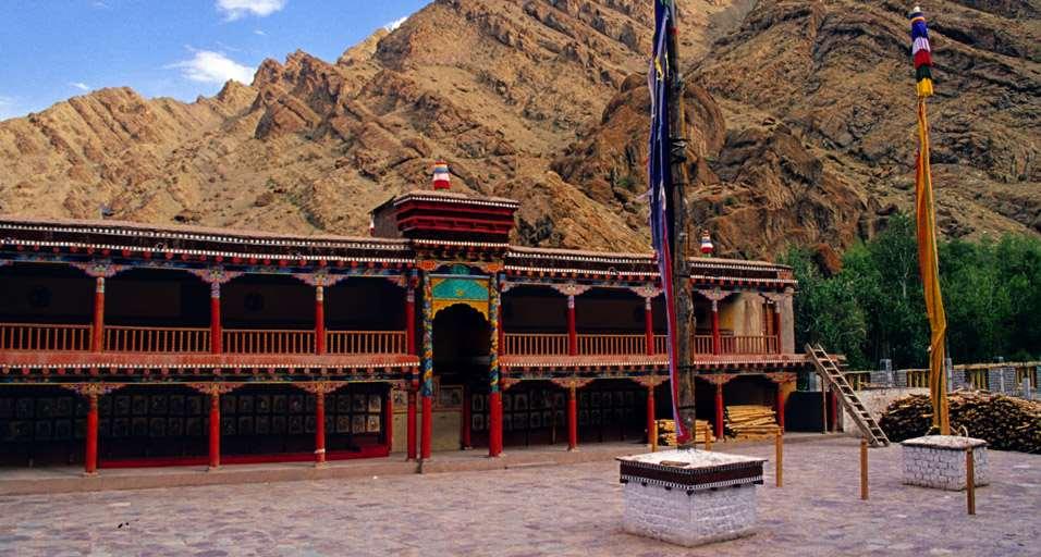
16 Hemis Monastery


17 Confluence of Zanskar and Indus Moonscape on way to Lamayuru


18 Thiksey Monastery, Ladakh Spituk Monastery from runway


19 Enjoying camel ride at Hundur, Ladakh Bridge on way to Pangong. This is where 3 idiots movie was shot


20 Amazing Chang La pass
21
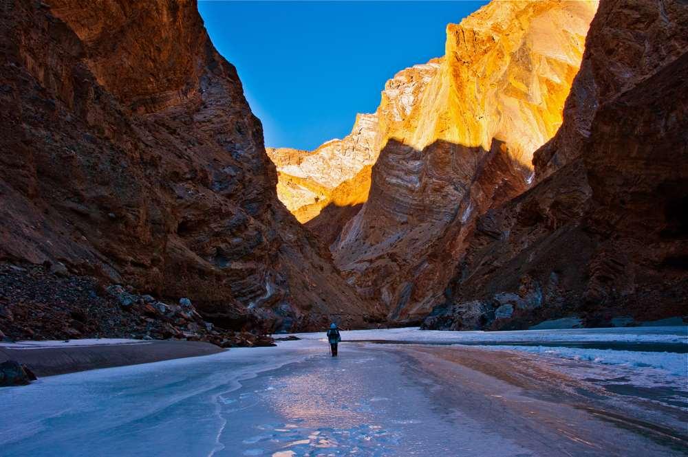
22 Trekking in Ladakh While at Ladakh, you can enjoy following treks which would provide you with beauty, culture and heritage, excitement and offcourse thrill of crossing over passes would be an awesome experience Markha Valley Trek This trek starts from Spituk and ending at Hemi passes through Ganda La (15748 ft) and Kongmaru La, (17060 ft) apart from enjoying views of Stok Kangri at ft and Kang Yissey at ft. Apart from the passes and mountain ranges, you get to experience Ladakhi culture at various remote villages, monasteries like Hemis, interact with monks and understanding about Tibetan Buddhism and wilderness of Snow Leopard, Baharal, marmot, wolf to name a few animals you would encounter. This trek is moderate in effort but best in category of experiencing passes. Trek days: 8 days Total days: 12 days Highlight: Markha Valley, Ganda La and Kongmaru La, monasteries, culture and Stok Kangri peaks. Grade: Moderate Season: May to September Chadar (Frozen River Trek) This trek is considered as one of the most exciting and unique treks as you would walk on the banks of of Tsarap River. The trek normally starts at Chilling Sumdo (crossed road) and as you trek will lead to a narrow valley filled with breathtaking views of ice-peaks and unexpected hanging icicles that will attract your gaze for some time. You will spend the night at cave camps with the help of a born fire that will keep you warm and relaxed. Chadar (Frozen River Trek cont) The Chadar trek is one such route, connecting villages like Lingshed in the Zanskar valley (deep in the mountains) with Chilling (on the road to Leh) along the frozen Zanskar River. This route has been used for centuries for trade and transportation, as some villages become completely inaccessible between November and March. Mid Jan to end February is considered the best season to walk on the frozen river and reach Lingshed which has a fantastic monastery apart from breathtaking views of mountains and passes along the icy river. Trek days: 14 days Total days: 16 days Highlight: Lingshed via frozen river, very remote villages, Zanskar river Grade: Difficult Season: Mid Jan to end Feb Temp : - 40C Stok-Kangri Trek / Expedition Probably the only trek from Indian side which can take you to 20,086 feet thus firing out the passion for trekking and looking almost like mountaineering. Even the base camp is at 16,300 feet higher than any other route in this region. Above all, Ladakh is known for passes and it would be extremely exciting to see from the top. The trek route from Shang to the Stok Kangri base springs a very pleasant surprise in this regard. On this trail you get to see the purples, the browns, the gold and the yellows of the mountains as you usually expect. Along with these, you also trek through vast meadows of green grass laden with flowers all flourishing at heights above 14,000 ft. The trail takes you through some unimaginable, unexplored sides of the Ladakhi mountains. (Stok-Kangri Trek / Expedition cont) This is one of the most sought out by trekking enthusiast and usually the trekking period starts from end May to early October. On the summit day, we normally start by 1:00 AM in morning to reach by 5:00 AM to see the sun on the summit. Plus, the weather might turn bad during the day and hence safer to do very early in the morning. Trek days: 10 days Total days: 11 days Highlight: Stok Kangri peak at 20,086 feet and Stok village Grade: Streneous Season: May to October Markha Valley with Stok- Kangri Trek To add more challenge to the Markha Valley trek, you could add to the route an extra pass which stretches to 4900 meters. The trek is recommended for only those who have a prior experience in the trekking. This trek is not recommended for novice trekkers who are experiencing the thrill of trekking for the first time. This trek being the difficult one receives less number of trekkers. The trek offers a myriad diversity in the landscape. One can avail the opportunity of viewing a breathtaking and scenic beauty of the Markha valley through this trek. The trek is a perfect blend of challenge, thrill and captivating charm of the beauty of the nature. Trek days: 11 days Total days: 14 days Highlight: Stok Kangri peak at 20,086 feet and Stok village, Hemis, Markha Valley, Ganda La and Kongmaru La Grade: Streneous Season: May to October
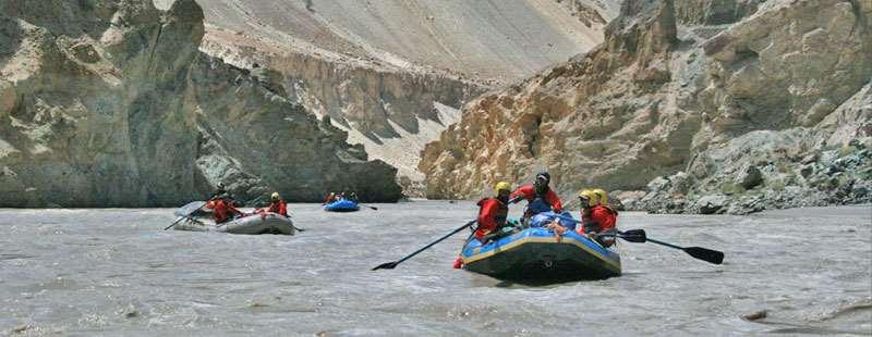
23 River Rafting in Ladakh May to October While in Ladakh, you could enjoy river rafting in two options. 1. Indus River Rafting: From the time one starts from Leh and proceeds towards Uletopo or Ule, you would find Indus river flowing where you have great rapids towards Ule and beyond. This would be the ideal place for rafting and the point starts from Sangam where Zanskar river and Indus river meets. The Indus River, locally known as the Singhe Khababs (out of Lion s mouth), flows across the north west to the south east, passing through Ladakh and flows into Pakistan where it joined Shayok and Suru to become major historical Indus River. The Indus, originates near the Kailash Mountain and the Mansarovar Lake in Western Tibet. Water levels remain high during the month June to late August, which is the best season for fascinating rafting expeditions The Indus River rafting offers a spectacular river rafting course along with camps at interesting locations. Much easier and quieter than the Zanskar, the Indus is suitable for Grade II and III trips. The river, which originates in Tibet, flows down through Ladakh, past Leh, and then passes into Pakistan. 2. Zanskar River Rafting: Zanskar River originates from the high altitude plateau of Sarchu on the border of Himachal Pradesh and Jammu and Kashmir. Originally known as the Tsarap the river gorges a path out of the rocky mountains of western Himalayas, dropping in a continuous torrent of class V rapids. The river then eases into the forbidden Kingdom of Zanskar and slowly flows past the capital at Padum. Here it joins with the Stod river which flows down from the Pensi La pass on the road from Kargil to Padum. Keep around 2 days handy while you plan for rafting in your total tour plan as the rafting would be highly tiresome and exhaustive. There are various places both in Indus and Zanskar where one can plan out for rafting. They are as under: Phey - Nimo route This route consist mostly of Grade II or III easy rapids is that it passes through astoundingly beautiful mountains, many of them with tiny hamlets and imposing old monasteries nestling among the valleys. Starting from Phey Village, about 12 Kms from Leh and ends Indus-Zanskar confluence at Nimo, about 36 kms from Leh. Upshi - Kharu route This route is somewhat long as compare to the Phey-Nimo, but not too difficult. The stretch between Upshi and Kharu consists of I and II rapids, although there are some grade III rapids too. The starting point is at Upshi, about 90 Kms South east of Leh, along the road which leads south to Manali. From Upshi, the river makes its way westwards to Kharu, along the road to Leh. Phey - Saspol This rafting trip starts from Phey, about 8 kms south of Leh and its end at Saspol, on Leh-Srinagar Highway, near Alchi. This route is short and relaxed enough to enjoy the breathtaking view of landscapes and beauty of tiny hamlets on the both side of Indus. Kharu - Spituk It starts from Kharo, about 45 Kms South-East of Leh and ends at Spituk, just short of Leh. This route is specially recommended for the beginners and amateurs. Saspol Khaltsey If you are experienced rafters, you may try the more challenging route between Saspol and Khaltsey, which has kilometre long series of rapids at Nurla. The rafting will finish at Khaltsey 90 Kilometres from Leh. Contact Himalayan Fantasy at or write to us at info@himalayan-fantasy.com to know more on rafting circuits and costs.


24 Bike tour of Ladakh (Cycling) During months of June end to September 2 nd week, you could experience the fabulous and thrilling cycling from Manali to Leh and Khardung La at 18,380 covering a distance of around 470 kms in 13 days time and then catch flight back to your destination from Leh. Here is a short description of how the tour could be planned. Day 01. You go with a bus from Delhi through the hill-landscape of Himachal Pradesh into the valley of Kulu and the Beas River along into the town of Manali(2000m) Make your accommodation in Manali and stay for 2 days for acclimatization before starting the bike tour. Day 02. The mountain bikes will be provided to you. Start on your first reconnaissance-trip: A forest hides a temple, called Hidimba Devi, carved out of wood. Later you drive steeply up to "Old Manali", a picturesque village close to the ruins of the Fortress Mandakot. Along the Beas River you will find the hot spring called as Vashist springs. Day 03. Today would be strenuous ride as you are biking to Rohtang Pass from Manali by crossing fascinating Solang Valley. This trip passes through the "alpine" forest to the Rothang La serves for your acclimatization. After the last village, called Kothi, many serpentines bring you to the Rohalla Falls and after a big turn into a small valley you reach the camp where you stay overnight (3000m). Have a nice dinner and take rest after travelling for 5-6 ours and covering 35 km. Day 04. In many serpentines and over green pastures, it goes to the Rothang La, 4060m. There you can enjoy the view over the glacier summits of Spiti, and the mountains of Ladakh. It s fantastic! Now you enjoy the downhill of about 1000 height-meters to the village of Khoksar. There is the first check post, but you need not a permit. You are now in Lahaul-Valley. In softly up and down, you reach Tandi, the campsite at the place, where the rivers Chandra and Bhaga comes together. (2800m). Day -Performance 75 km, 6hours. Day 05. You start early morning into the canyon and come to Keylong, the capital city of Lahaul-Valley. Prayer flags and Mani walls clarify for you that you are in a Tibetan- Buddhist culture-area. Four monasteries surrounding in the former capital of Lahaul invite you for sightseeing. The monastery of Kardung shines at the opposite hillside in the sun. After a powerful uphill in the afternoon you reach at the camp Jispa (3200m). Day 06. Now the wood border is behind you, passing Darcha (3235m), in a big river-landscape, you reach Patseo (3650m) on a comfortable half-stage. You start your trip intentionally quietly, in because of the adaptation of height. There you get a lot of fresh tea, and drinking liquids like water and tea is very important during the acclimatization. Day- performance 32 km, 3 hours. Day 07. The Baralacha La, 4670m, is the first key-position on this demanding tour. The timberline remains behind, the landscape becomes balder. The height of this pass is a crossing- point of archaic caravan-ways. Three rivers rise from here: Bhaga, Chandra and one of the brooks of Zanskar, which will follow you from now on at your way in direction northwards to Indus. You have crossed the weather- difference of the Himalayan. You are very proud that you have managed this without help of the car, which accompanies you. Now, the indented mountains of Ladakh and Ruphsu are in front of you. Campsite in Sarchu at the Zanskar River. The cook there pampers you with original Indian or Nepalese food. The comfortable tents will give you a gently night. This day you pushed up your bike 1800 meters and clocked 55km. You need 6-8 hours of rest and that s recommended.
 and the last ascent bring you to the Lachalung La at 5150m.")
25 Day 08. Early morning you start the strongest steppe. For approximately 38 km distance, the road is flat until you reach Gataloops. The next 800 meters you push up your bike in many serpentines and reach Nakee La 5050m. A short downhill (250m) and the last ascent bring you to the Lachalung La at 5150m. On the pass travelers have established Manis out of stones, which should appease the mountain- demons. The wind blow over the colorful prayer-flags. If you have acclimatized very well, at Lachalung La 5150m, you do not feel thin air and you zoom on.. Over the trans-himalayan ranges, you find stones piled up, until you rach Pang the second arm of the Zanskar is reached and Zara Chu. Immediately beside a control- station you will stay for camping in the tents at, 4500m. You are hungry and Tibetan food-momo would be ideal or Noodles with Beans, Pancakes with Jam, Dal with Rice, and so on. Day-Performance 84 km, 7-9 hours. Day 09. You slept well in the Jute-tent. After breakfast, you start slowly at a short ascent to the Mora Plain at 4700m. As you reach Rupshu typical, waterless high deserts, you find Changpa Nomads stay here in almost isolation at this reach of 5600m with high pastures with their yaks, sheep s and goats. In interesting excursion, you bump over unfixed tracks to a clear source that bubbles between mountain-backs from green pastures. Further to Tsokar, a no-flowing-off salt lake. That is eaten by a sweet twin lake, and in its mineral wealth almost suffocates. Rust and strip-goose are in this paradise equally at home, as the Tibetan gull. Few years ago people have transported the precious salt with goat stoves into the endless corners of Ladakh. It is a fantastic panorama! Campsite near the lakes. Day performance: 57 km, 4 hours. Day 10. Starting from Tsokar you will reach Taklang La, 5303m separates you from the Indus-Valley. In a far swinging back, soft traverse, the street wins the saddle before dabbling, 4800m. You can see it as a thin line at the steep hillside. Also like the audacious turning of the old caravan-way, from prayer-masons. In three hours you are above and will be rewarded with a wonderful view on the mountains of Karakoram. It s a stormy corner and you stay only for a short time on the pass. After taking some pictures, you have a gently downhill till Üpshi, 56 km, without treating! The street is in very good competition and you reach the camp in the romantically canyon of the Gya-River in 5 hours time. Day 11. Its cold on morning in the shadow of the canyon. We start early to the Indus-Valley. We follow the green wideness till a hidden valley. In a short uphill, 7 km, we reach the monastery of Hemis. There we have sightseeing and in the restaurant our second breakfast. Past midday we are on the last trip to Leh, we pass the monasteries of Stakna, Thikse, Shey, and its time enough, to make a short visit. A last ascent, 300m, will bring you to Leh. There are many guesthouses and restaurants. Day 12. You slept very well and it s time for sightseeing and shopping in Leh. It s fantastic here; they have everything for you in the market area consisting of all kinds of fruits, what you missed in the past 11 days. It is warm in the sun, you enjoy at a black coffee and Donates in one of many shops. You go by bike to the monastery of Sankar, the Shanti Stupa, and the Tsenmo Hill. Day 13. With less luggage you start early morning to the highest motor able pass of the world, the Kardung La 5606m. The ascent begins at 3540m and end by 5603m. There are 46 km. Behind Leh you leave the last small village, Ganglass 4000m, then you reach 2 hours later the check post in South Pullu. Only 14 km separate you from the summit. You need 3 hours to the pass. The view along the street is always fantastic, on Kardung La; you get fresh tea or Maggie noodle soup. There is also the highest Gompa, you can make a visit. The reward of the day is a fantastic downhill to Leh. This journey is very strenuous and sometimes depend on the weather. You need a technical perfect bike, fully fit body and enough batteries to click photos as you drive your bike to glory and achieve remarkable feat from Manali to Khardungla on cycle or bike.


-Khardung La-Nubra-Pangong-Leh Season: June end to October The Passes: Rohtang Pass- 3980m Baralacha la pass- 4892 m Tanglang la")
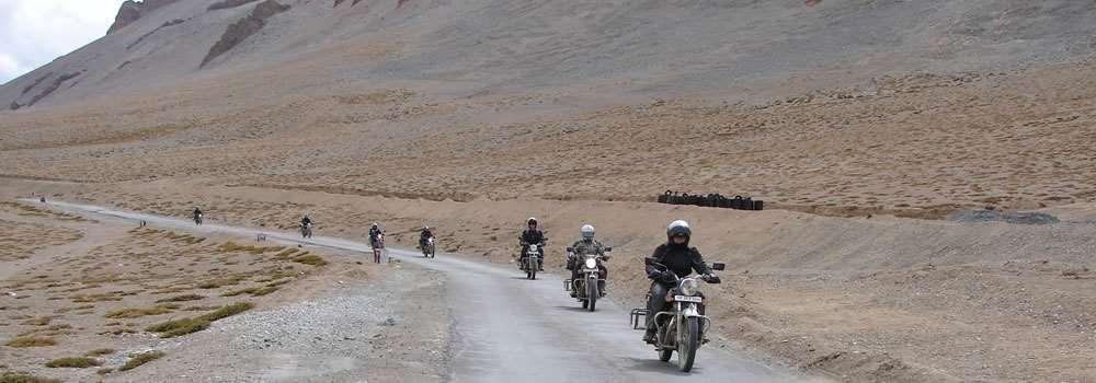
26 MOTOR BIKE TOUR OF LEH AND MANALI From June end to September end, the Himalayan town of Manali has a festive look with bikers thronging to hire bike on rent and zoom to Leh covering journey of 475 kms and then drive 37 more kms from Leh to reach world s highest motorable route at Khardungla. Altitude at this place is 18,380 feet and the biker feels delighted of being there and made this treacherous journey without any much challenge on the way. I m providing herewith certain details which would help fellow bike enthusiast to take on the journey of their dreams. Our journey begins with reaching Manali on a sunny yet cold morning and checkin into hotel. After breakfast, Himalayan Fantasy folks walking past us and providing information on when the bike would be assigned and planning for the bike journey including logistical arrangements, spare parts, terrain maps, food to be carried enroute and not to forget fuel cans because after Tandi, there is absolutely no fuel and Enfiled bike 500cc cannot be pushed on this trecherous terrain in case of fuel shortage. Nevertheless, this morning, we just take a tour of Manali and chill out with Himalayan Fantasy guide and bike expert and rest for the day. The route map enclosed here shows the route we are going to take in this 11 days and 10 nights which is correctly called as Trans-Himalayan Bike tour. Route Manali- Naggar- Jana Water fall - Keylong Sarchu-Leh(ladakh)-Khardung La-Nubra-Pangong-Leh Season: June end to October The Passes: Rohtang Pass- 3980m Baralacha la pass m Tanglang la Pass m Khardung la pass m Manali 2. Hadimba Temple 3. Naggar Castle Today, after breakfast we wanted to try our new bikes and headed towards sightseeing of Manali and Kullu. Drive was wonderful and weather held things up. By this time, we had made very good friendship with guide and he gave us a route map of Kullu, Naggar and Manali. We spent whole day on our bikes touring entire Naggar and Manali.
27 Sissu Camp 2. Rohtang Top 3. Rahalla Falls Morning after breakfast we were all charged up to leave for Sissu. Started by AM & drive of 90 Kms by crossing Rohtang Pass 13050, known as getaway pass for Lahaul & Spiti valley, we enter to Lahaul valley. On the way we stopped at Nehru Kund, Rahalla falls and other fabulous view points and arrived at Sissu Camp. Lot of fun activities organized by Himalyaan Fantasy guides ensured that we enjoy and had a great night and rest with fantastic food Tandi 2. Deepak Tal 3. Suraj Tal This morning after breakfast we started to Sarchu by driving approx140 Kms. Our first pit stop was at Tandi where Chandra and Bhaga joins or Sangam. Also this is the refueling at Tandi after which we would not get it for around 200 kms. We not only filled our tank, but also the cans we had as spare. Then we started our drive towards mistifying Deepak Tal & Suraj Tal (known as origin of Bhaga river) and crossed Baralacha Pass (16020 ft) By 11:00 am, we reached Bharatpur where Himalyan Fantasy folks were waiting with banner for a tea break and finally reached Sarchu by late afternoon at 13,999ft Nakee La 2. Lachung La 3. Taglang La Early morning after breakfast we started to Leh. This day is what we were looking for and then Himalayan Fantasy team had given us so much of information that we wanted to experience for ourselves. From the place we started, drive was for 250 Kms by passing through Nakeela and Lachangla Pass 16,617 ft. We had packed Lunch at Pang. After the Lunch we started our drive to Leh by passing through Skyangchu Thang (Biggest and Highest Plateau on Earth at a Stretch of 42 Kms) & Tanglang La Pass 17,585ft, second highest motorable road in the world and at 4:45 pm reached reached Upshi. After a small break we started driving our bikes along with banks of Indus river & Valley next to us. Passing through Thiksey monastery route, Shey Palace, White Lotus School which had become popular in 2008 due to shooting of 3 idiots there and Leh palace we reached hotel at 7:00 pm and time to take shower and rest. The folks were right there helping us with all that we needed and the mechanic was doing his bit of checking our vehicles and doing small servicing. Seeing their enthusiasm, we were even more charged up Shanti Stupa 2. Magnetic Hill 3. Sangam Today our main objective was to explore Leh. Having heard lot of Leh, we wanted to see everything we can. Initial idea was to only visit Sangam but then we drove until Lamayuru at a distance of 162 kms and while return visited Alchi monastery which was fabulous experience. It was very nice of Vilas from Himalayan Fantasy to give us a small lecture on Tibetan culture and tradition in monasteries while we attended a corporate course conducated by him for couple of hours while he gave gyan on Project Management and Spirituality. This indeed helped us to understand the inner meanings of stupas, prayer wheel, flags etc., apart from the paintigs and murals we see on monasteries. If not that, we would have ended up in just visitng some monasteries and not knowing what they mean. We also visited Hall of Fame while return from Alchi monastery.
28 Khardung La 2. Sand dunes 3. Nubra road Today was one of the most exciting day. We were to conquer World s highest motorable road at Khardung La. Khardung in local language means Snow and La means Pass and that is what we are going to corss to reach Nubra Valley. The actual name for this valley was Ldumra which means Valley of Flowers. After breakfast on our bikes we started to Nubra Valley via Khardungla (Highest Motorable road in the World, 18,380 ft) The entire tour was excellent as we followed one another and stopped at Khardung La for picutre perfect break. We arrived at Hundur by afternoon and lunch was served at at Camp. We explored rest of the day by driving to Deskit monastery, Hunder Villages and camel Safari in Sand Dunes between Deskit and Hunder Village Deskit 2. Bikes at N.Pullu 3. Tsemo Hill This morning after breakfast we started to Leh after visiting fantastic monastery of Deskit. This monastery has powers to make our mind subdued and we felt so much relaxing than never before. Everyone of us enjoyed a lot and it was time to retrace the same path as we had come via Khardung La and had a nice exploration fo Leh Palace and Tsemo Hill and monastery Chang La 2. First glimpse of Pangong 3. Pangong Lake We had seen 3 Idiots so much that it was hard to wait to see Pangong Lake.After breakfast, we started to Pangong lake and the entire route is so much breathtaking.we wanted to reach by 12:00 pm as we wanted to spend more time in the lake than anywhere else. To our surprise, we got some snow storms at Chang La which put a pit stop break for a considerable amount of time. With navigating carefully, we reached Pangong at 3:00 pm and checked into Pangong Retreat camp where in the staff were waiting for us. As soon as we entered, we were welcomed by drink and nice food. We then proceeded to play in water but then found that it is too chill to get into it. Had a very long walk and returned back to our tents at 7:30 pm and time for dinner and rest Bridge 2. Hemis 3. Thiksey Today, we were to return back to Leh taking the same route. We started relatively late so that we just reach Leh and hang our boots for the day and return back the bikes and conclude this fascinating journey. We started our journey by crossing bridge which you can see in 3 idiots also.we reached Tangse, Durbuk and then to Chang La. Enroute, we saw yaks grazing, marmos and wild ass. It was such a nice feeling. Then, we proceeded to Hemis monastery, Thiksey monastery and Shey Palace before reaching Leh. Day 11: This morning, it was time to say goodbye to Ladakh as they say in local language Julley Ladakh. Also thanks to Himalayan Fantasy and Overland Escape who have created Destination Ladakh portal to make this tour happen.
29 Ladakh Best time to visit May to October. Leh is open throughout the year Climate condition Arid and dry. Snow storms from Jan to April. Can snow in May and June as well. Temperature Leh : 10 C to -2 C from May to June 20C ~ 25 C from July to Sept -5 C ~ -10 C from Nov to March Entire Ladakh: Warm weather June ~ Sept Moderate April ~ June Very cold : Nov ~ March Mobile phones Postpaid Private and BSNL works in Leh and only BSNL postpaid in entire Ladakh. For detailed itineraries, please visit: All our packages are customizable and hence the itineraries are just suggestive. Do call us for customizing as per your needs.


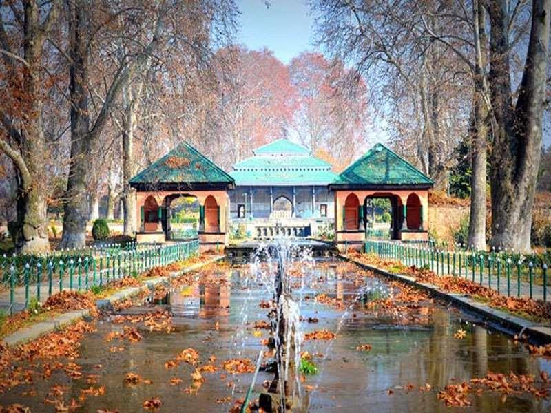
30 KASHMIR Kashmir is known as paradise on earth due to natural splendor and beautiful gardens and off-course apple trees and dry fruits. Every season in Kashmir is always beautiful. Two major Himalayan ranges, the Great Himalayan Range and the Pir Panjal, surround the landscape from the north and south respectively. They are the source of great rivers, which flow down into the valleys, richly forested with orchards and decorated by lily-laden lakes. Mughals were the first to note this earthly splendor and called it Paradise on Earth, They developed gardens and fountains and now known collectively as Mughal gardens. They also patronized the development of art and craft among the people of Kashmir, leaving behind a heritage of exquisite artisanship among its people and making the handicrafts of the land, prized gifts all over the world. Finally, Kashmir is known for saffron which is used in homes as spices and also for pooja and rituals.
31 BRIEF HISTORY Kashmir is called Paradise on Earth due to the reason that it has one of the spectacular views, streams, gardens, valleys, flowers in full bloom and fruits. The beauty and the salubrious climate of the valley was known even from the ancient times. The mythological traditions supported fully by the research of geologists confirm that the valley originally was a huge lake called "Satisar", ( the land of goddess Sati, consort of Lord Shiva ) and its waters were blocked near Baramulla (ancient Varahmulla). In the words of Sir Francis Young Husband, "The huge lake must have been twice the length and three times the width of the lake of Geneva, completely encircled by snowy mountains as high, and higher than Mount Blank, while in the immediately following glacial period, mighty glaciers came wending down to the Sindh, Lidder, and other valleys even to the edge of water." Kashmir's greatest historian Kalhan writes about his native land : "It is a country where the sun shines mildly, being the place created by Rishi Kashyap, for his glory - big and lofty houses, learning, Saffron, icy cool water and grapes rare in Heaven are plentiful here - Kailash is the best place in the three worlds (Trilok), Himalayas the best place in Kailash, and Kashmir the best place in Himalayas". With advent of Muslim invasion in the North, Kashmir valley underwent metamorphical changes in culture and heritage of the region. Sultan Shamas-ud-din took over from Queen Kota after her death and his dynasty ruled for more than 220 years. During this period, the region underwent total cultural revolution and firmly converted into Muslim population. Various Sultans ruled over the period until 1587 when Emperor Akbar having visited Kashmir to study the nature and surroundings felt the need to conquer this paradise for himself. The Moghuls remained in power here, from 1587 to 1752, and in this period undoubtedly the people enjoyed peace and orderly Govt. There were some rapacious officers, but on the complaint of the people the Moghul rulers immediately removed them. It was in 1579 that illuminated Moghul emperor Akbar visited Kashmir. About eighty thousand Kashmiris were entertained by Akbar at Id-Gah. During his reign Raja Todar Mal, the great Finance and Revenue Minister, made revenue settlement of the valley, which in its broad features forms the basis of the present revenue settlement in the valley. Akbar built a new town near Hariparbat and called it Nagar-Magar and built the massive wall around the hill. The great emperor visited the valley three times, and with him, came a large number of Moghul grandees, noblemen and army generals. The fame of the valley spread throughout the country and a very large number of people started to visit the valley. It was in the time of Jahangir that the beauty of the state attracted thousands of visitors to the happy valley. The great emperor visited the State thirteen times. The Moghul rulers never came alone, but were always accompanied by hundreds of Nobles, Amirs and Umras, Princes and Army Generals. Jahangir came virtually, under the spell of the scenic beauty of the place, and wherever he found a hill coming down gently to a spring or a grove of majestic Chinar trees or a beautiful lake, he utilised the place for planting a pleasure garden. Shalimar and Nishat gardens on the banks of Dal Lake, would keep Jahangir's love for natural beauty ever fresh in our memory. He laid gardens at Achable and Verinag. Perhaps no other ruler has ever paid so much tribute to the beauty of Kashmir as Jahangir did. Bad period started during 1752 to 1819 AD when Afgans defeated Moguls and made their inroads into valley and Kashmir came under rule of Kabul, Afghanistan. The period is generally marked as bad years for Kashmir as most of the people were displaced or killed when revolted. At last the reign of terror broke the patience of the peace loving people, and a deputation of Kashmiris led by Pandit Birbal Dhar, and his son Pandit Rajakak Dhar, left for Lahore and fervently requested Maharaja Ranjit Singh to conquer Kashmir. Three prominent Muslims helped Pandit Birbal Dhar in his escape from the valley. They were Abdul Qadoos Gojwari, Mallick Zulfiqar and Malik Kamgar. In 1819, 30,000 soliders of Maharaja Ranjit Singh attacked Kashmir, defeated the Pathans, and the state became a part of Ranjit Singh's empire. On receipt of the news,maharaja Ranjit Singh bestowed honours in Dhar family and Lahore was illuminated for three days, Sikh rule lasted for only 27 years and during this period 10 Governors administersd the country one after another, out of whom the last two were Muslims. In the beginning Sikh rule also proved to be oppressive but this was better than Pathans. Sikh rule came to an end with Engilsh taking over due to two Anglo-Sikh war and from that time, Dogra kingdom started from 1846 to 1957 when lot of reforms took place under Raja Gulab Singh and finally with accession to India by Raja Hari Singh in 1947, but then the war with Pakistan in 1948 created more problem for the valley with Pakistan making claims of Kashmir when the Maharaja had acceeded to India. This problem can be felt and seen even today, but from 2008 onwards, travelling in Kashmir has not become a problem atleast for tourists from other parts of India.
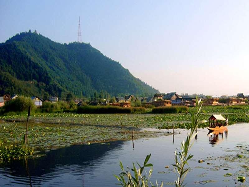
32 Jammu Jammu is the Duggar land where the past still dwells. It is the land of grand ancient temples and beautiful palaces,all nestling in the foothills of the Himalayas. Jammu apart from temples is known for forts and forests.bahu Mata is the presiding deity of Jammu. The Dargah of Peer Budhan Ali Shah is the other shrine that protects Jammuites. The other major tourist attraction is the Raghunath Temple Complex. There are two charmingly contradictory aspects to the city of Jammu which one can see while shopping. You will find traditional and most mordern items and there is constant demand for both. Vaishno Devi Around 61 Kms from Jammu and 13 Kms trek from Katra lies the famous Vaishno Devi Temple. Other temples around the vicinity are Raghunath Mandir, Kalka Mandir and Bhumika Mandir. Other than that you would be amazed with Shalimar Park and the Chintamani Park which are very beautiful. Patnitop Though not as popular as most other hill stations, Patnitop is as beautiful and serene. This famous meadow, situated at an altitude of 1950 metres, is surrounded by dense woods and the lush greenery of the pines. An ideal place for walks and picnics, one can even indulge in pony rides along the lesser known trails and camps. Srinagar This is the heart of Kashmir valley and is divided by the River Jhelum. Mughals beautified this place as they reached here to escape from heat of Delhi or Northern plains. They were fascinated by the pristine valleys and climatic conditions that they named it as Paradise on Earth While at Srinagar you cannot afford to miss Dal Lake with its maze of intricate waterways and channels, floating islands of vegetation and houseboats that look so firmly moored that they could almost be islands and hotels on islands which look like they could simply float away. A ride on Shikara is must for every traveler to unwind his day or start the day. The waters of the lake are so clear that swimming in them is quite a refreshing experience. While at Srinagar, you can visit the famous Mughal Gardens, Chashmashahi Bagh, Nishat Bagh,Shalimar Bagh, the Dal & Nagin Lake and end with Shakaracharya Temple. Pahalgam 96 Kms east of you Srinagar will take you to the shepherd s village as it was called earlier and now named as Pahalgam. Upland meadows and hills covered with pine forests form the backdrop of Pahalgam. An ideal delight for trekkers, one can enjoy fishing in Pahalgam. The Lidder River is divided into three fishing belts, offering bountiful opportunities for fishing. Gulmarg A huge shaped meadow with gently undulating slopes, ringed by fir trees and snow-capped peaks, is how one would describe Gulmarg. A nature lover s delight, one can generally hear the birds sing and the sound of the wind blowing through the pines. A heaven for trekkers, one can trek the steep hills to the Seven Springs and view one of the highest peaks, Nanda Devi Peak. By December, Gulmarg is a paradise for skiers, with snow covering the lush meadows. Sonamarg This Meadow of Gold is a quiet valley carved by the Sindh River and encircled by placid lakes and awesome glaciers. Lying at an altitude of 3000 metres, it is located 80 Kms north-east of Srinagar. The journey to Sonamarg itself is an enchanting wonderland of nature s beauty. Yousmarg Is a medow which mesmerizes tourists with its scenic beauty and mountains comparable to European Alps. Situated amidst Sang Safed valley, Yousmarg is reputed for having some unique spring flowers. It also has some of the highest peaks in PirPanjal range like Tatakoti 4725 mtrs and Sunset Peak 4746 mtrs. The mighty river Doodh Ganga makes this destination more thrilling. The natural slopes of Yousmarg offer skiing opportunities to experts. Verinag Situated at a distance of approximately 80 km from Srinagar and reached through the link road at a height of 1,876 m. It is said that the Verinag spring in Kashmir is the chief source of the river Jhelum. There is an octagonal base at the spring, surrounded by a covered passage. The Mughal Emperor Jehangir started the construction work on both the base as well as the arcade. It was during the reign of Emperor Shah Jahan that the work got completed. There are remains of Mughal pavilion and baths in Verinag was built. To the east. of Verinag Spring, another spiring is named after Nila Nag, the son of the famous Hindu sage Kashyap Rishi, to whom, goes the credit of establishing the territory of Jammu and Kashmir is one of the principle tourist attractions. Today, picturesque spring is surrounded by tall Pine trees and characterized by waters which are calm and sparklingly clear.
33 Kokernag is a town and a notified area in Anantnag. Koker means 'fowl' and nag means 'serpent'. The spring gushes out of the base of a thickly wooded hill from where it divides into channels, which resembles to the claw-foot of a hen, hence its name. Kokernag is at the height of approx.2000 mtrs and famous for gardens, largest fresh water springs in Kashmir Kokernag has been mentioned in Ain Akbari, where in it has been mentioned that the water of Kokernag satisfies both hunger and thirst and its is also a remedy for indigestion. Gurez This valley is located in high Himalayas of about 86 kms from Bandipore and 123 kms from Srinagar At about 8,000 feet (2,400 m) above sea level, the valley is surrounded by snow capped mountains. It has diverse fauna and wildlife including the Himalayan brown bear and the snow leopard. The Kishanganga River flows through the valley. The road to Gilgit runs through Gurez. The roar of mighty Kishan-Ganga river flowing across the valley, resonotes with surrounding mountains that lulls a visitors to sound sleep.the traditional log wood houses make Gurez no less than a European country side. Dodhpather Known for bow- shaped valley about 42 kms form Srinagar. It is a recent discovery in the valley covered with green carpeted meadows. An adjoining river resounds the soft wind passing through pine trees of the surrounding forests. It is said that the cattle grazing in the meadows of Dodhpather, produces rich milk in large quantity, and for this reason it is also called the "valley of milk". Shepherds from different areas travel to this place along with their cattle's and stay there for days together. This area also connected to Gurez valley on its north. A cup of tea with snack at tea stalls run by local people during the season at the main meadows could become your most pleasurable drink. A full day tour to Dodhpather with some packed lunch will definitely be a bonus to your visit to Kashmir. Mansar About 62 km from Jammu, Mansar is a beautiful lake sounded by forestcovered hills with its length more than a mile and width half-a-mile. Besides being a popular excursion destination in Jammu, it also has provision for boating for which adequate facilities are provided by the J&K Tourism. The history of mansar and surinsar goes back to the time of Mahabhartata. Babaruvahana, son of Arjuna and Ulpi (daughter of king Nag), was ruling this area and how Babruvahana was able to get mani or pearl from Seshnag happened at this very site and hence has historical importance. Mansar is a holy site as well, sharing the legend and sanctity of Lake Mansarovar. There are ancient temples on the lake side, which are often visited by devotees in large numbers. Some Hindus from the region perform Mundan (First hair cut) ceremony of the male baby here. Lolab valley Locally known as Wadi-e-Lolab is known for its fruit orchards, lake, springs and lush rice fields. Lolab can be easily reached by road. Travelers staying in Srinagar can easily reach Lolab by a local bus or hire a taxi. Poets like to refer to Lolab asa true destination and as land of love and beauty. Lolab valley is 5km wide and 26 km long. It is located at a distance of 120 kms from Srinagar in Kupwara district. Lolab is a combination of three valleys, Potnai valley, Brunai valley and Kalaroos valley. There are beautiful Nagmarg meadows, which separate Lolab from Bandipora district. The headquarters of Lolab is situated at Sogam. It is said that Sogam was very densely populated a long time ago, when Kashmir valley was still a lake called Satisar. Travelers visiting Lolab also visit the resting place of a famous saint Kashyap reshi, which is located at a distance of 1 km from village Lalpur. A spring called Lavnag can be found nearby. The spring is three feet deep and has crystal clear water. Gauri spring is another major spring in the area. Government has taken several steps to maintain Lolab Valley to its pristine beauty. Bhadarwah This is located on the foothills of middle Himalayas.The town is endowed with breath-taking natural beauty which is why it is popularly called "mini Kashmir".Apart from having picture perfect scenic beauty due to beautiful forests, there are many small streams flowing through various parts of the town.the Halyan river flows through the main market of the town.

34 Gulmarg Pahalgam
35 Shankaracharya Hill Shalimar gardens

36


37 Vaishno Devi Temple Fascinating Dal Lake
38 Kashmir Best time to visit March to September. Srinagar is open throughout the year. Climate condition Arid and tundra. Snow from November to March. Other months would be pleasant. Temperature Srinagar: 18 C to 6 C from March to May 25 ~ 14 C from June to Sept -5 C ~ -10 C from Nov to March Entire Kashmir Pleasant June ~ Sept Moderate March ~ June Very cold. freezing : Nov ~ March Mobile phones Postpaid Private and BSNL works in Leh and only BSNL postpaid in entire Ladakh. For detailed itineraries, please visit: All our tours are customizable and hence the itineraries are just suggestive. Do call us for customizing as per your needs.


39 HIMACHAL Nurtured by three rivers, Ravi, Beas and Sutlej, Himachal Pradesh is one of the most beautiful states of India and popularly known as Abode of Snow Hidden away from the heat of the plains and approachable within a overnight journey, this state of remarkable beauty provides respite to the tourists from the summer heat. The state encompasses in its fold, a series of magnificent valleys, towering peaks and glistening rivers crisscrossing each other. There are lush fruits, orchids, ancient temples, magnificent monasteries, green meadows and gurgling brooklets and keeps travelers mesmerized.
40 BRIEF HISTORY Himachal has a unique history from Vedic civilization to Aryan to Mongol descent as it is a combination of various tribes who settled in Himachal over various period of time. During vedic period, the inhabitants were known as Dasas or Kosals. After that Khasas migrated into Himachal from North West and dominated cultural, economic and social fabric of Himachal. Since Himachal is closer to Tibet, there was influx all the time from Tibet into Himachal and saw intermingling of Mongol culture into Himachali culture. These descendants were Bhots, Kinner, Lahaulas, Gujjar, Gaddi and Pangwal tribes who migrated into Kinnar and Champa valleys with a mix of Hinduism and Buddhism. Himachal people have a mention in Mahabharatha and these republics were called Janapadas each constituting an independent, political and cultural unit. During 2 nd century AD, the region saw invasions by foreigners from Central Asia. From Mauryan king Chandragupta and Ashoka to Kushan emperors, Himachal was ruled and formed the social mix of all cultural and political outfits changing fabrics and adding new ones. The hill kingdoms were subjected to periodic waves of Muslim invaders who swept through North India Kangra was plundered as early as 1009 AD by Mahamud Ghazni. The entire region came under Mughal rule in 1620 AD when Jehangir s army defeated the Katoch rulers despite their profound resistance during war. Mughal supremacy lasted for 160 years and after which Sikhs ruled Himachal for a brief period of time. After a while, Gorkha rulers form Nepal led by Amar Singh Thapa overthrew Sikh rulers and Nepalese ruled for brief period of time. But then, Raja Sansar Chand sought help of Maharaja Ranjit Singh and the Sikh army once again pushed the Gorkhas eastwards beyond Sutlej. As a treaty, Raja Ranjit Singh had to give away Kangra Fort to Sikhs. By this time, English had made tremendous progress in getting entire Northern India under their siege. British contingent were always challenged by Gorkha rulers who had by now captured almost all of Himalayan belt including Himachal and Kangra regions and this was become extremely difficult for English to explore Himalayas and expand their empire to Northern and Eastern tip of India. Finally, they declared war on Nepalese Gorkha regiment in 1814 with the help of chieftains who were promised restoration of original position before Gorkhas had taken siege. The war went on for a year and English with their artillery were able to defeat Gorkhas and with the treaty with English, they had to give away Darjeeling as penalty to English crown. In the meanwhile, Sikhs were able to gain positions by waging war with chieftains and seeing right opportunity, British waged war against Sikhs who were defeated in With this Kangra, Nurpur, Guler, Suket, Mandi, Kullu, Lahaul and Spiti came under direct control of British. Many westerners started visited Himachal and making their inroads into culture fabric of Himachal. The first was a Christian missionary who came there to spread words of Lord among the locals and converting them from Hindu, Sikh and Buddhist faith to Christianity. However, after futile attempts by British to convert people of this region, they gave up and came up a different strategy to make people fight themselves and support the British. British being highly political and knowing how to play with emotions of people started with divide and rule among the local kings or rulers thus ensuring that British would be the only people to resolve issues which come up with different dynasties which ruled Himachal. During this time, British had made their complete inroads into North, East and West India and were virtually ruling everywhere. In order to subdue the local populace of Himachal, they set up Viceroy office in Simla which served two purpose. One, to have control and suzerainty over Himalayan region and two, was to escape heat from the plains below during summer. British started ruling entire India from Simla which became summer capital. After independence, the state of Himachal Pradesh was originally formed as a centrally administered territory on 15 th April, 1948 by merging around 30 hill states of Punjab province. Till 1966, the state had only 6 districts but was then enlarged to include Shimla, Kangra, Kullu, Nalagarh, Lahaul and Spiti. Himachal became full-fledged state on 25th January, 1971 with Shimla as its capital. Himachal has been developing at a great pace and you can find hotels of every kind in Shimla and Manali. The pristine charm is still retained at Spiti and Lahaul valleys as the stay is basic but interesting. While at Himachal, you will explore lot of things in this land of Abode of Snow which cannot be imagined while at our seats in offices. Come and experience near bliss in Himachal Abode of Snow
41 Generally, Himachal Tourism has been divided into four interesting travel circuits. Sutlej Circuit Passes through the shiwalik foot hills through apple orchards, forests of pine, oak and deodar, majestic monuments of the Raj, snow covered ski slopes and the furious Sutlej river. This circuit covers Rohru - Rampur - Sarahan - Narkanda - Naldehra - Tattapani - Shimla Kiarighat.. This voyage also includes Renuka, Paonta Sahib and Nahan. Beas Circuit Passes through highly picturesque Beas valley - the valley of gods. Flower covered meadows, terraced fields of apple, paddy, maize and the sparkling Beas river. It covers Shimla - Mandi - Rewalsar - KulluManali - Rohtang - Nagar Manikaran - Delhi. One can also continue to Leh across the Baralacha pass. Dhauladhar Circuit Passes in the shadow of the mighty and majestic snow clad Dhauladhar ranges, which dominate the beautiful Kangra valley, dotted by flower filled meadows, temples, tea gardens and flocks of sheep. It covers: Chintpurni - Jwalamukhi - Kangra - Dalhousie - Khajjiar - Chamba - Dharamsala - Chamunda - Palampur - Jogindernagar Tribal Circuit Passes through a spectacular terrain of river valleys, cold desert mountains, high passes, snow capped peaks, icy lakes, mighty glaciers-an exotic tribal country dotted by monasteries. It covers: Shimla - Narkanda/Hatkoti - Sarahan - Sangla - Kalpa - Pooh - Nako - Tabo - Dhankar - Kaza - Losar - Kunzam - Koksar - Sissu - Keylong - Udaipur - Trilokpur - Rohtang Manali. Manali Manali gets its word from Manu who is called as the person who created humanity and hence in Sanskrit is termed as Manushya or human who came to this world due to Manu. This place Manali came into existance once the great deluge dried up leaving behind a breathtaking place in Himalayas and termed as Himachal or abode of snow. Manali is extremely picturesque and also crowded by tourist alike. This place has lot to offer from artistic temples to castle, to art gallery, valleys and starting point for Solang and Kullu Valley apart from Rohtang Pass. Shimla Shimla or Simla as it was called became summer capital of British under East India Company rule. This picturesque town was choosen by English to beat the summer heat of the plains of Delhi and very approachability from Delhi. Situated in the lower ranges of the Himalayan mountains, it is surrounded by pine deodar, oak and rhododendron forests. Towards the north lie the snow-covered highranges, while the valleys breathe whispering streams and swaying fields. Within the town are host of splendid colonial edifices, quaint cottages and charming walks which captivates tourist who visit this exquisite place. Naldhera Located at distance of 22 km from Shimla, Naldehra (2044 m) is a heaven for tourists. It boasts of the oldest 9 hole golf course in the country. The well groomed Golf Course is a lovely verdant, perhaps one of the finest and sporty in India. Crowned with a springing turf the Golf Course was suggested by Lord Curzon. He was so enchanted by the place that he gave his daughter Alexendra, "Naldehra" as her second name. It is the venue of many competitions. The Nag temple is also situated here and Naldehra derives its name from it. Narkanda Situated at an attitude of 2708 meters on the Hindustan Tibet road (NH - 22), and 65 kms from Shimla, Narkanda offers a spectacular view of snow ranges. This is an ideal retreat for the tourists who seek seclusion in mountains. It commands an unique view of the eternal snow line, the inviting apple orchards and dense forests. Narkanda is famous for Skiing & Winter sports. During these days the slopes come alive with skiers. The skiing at Narkanda was started in 1980 and since then HPTDC is conducting skiing courses every year. Narkanda is a gateway to apple country of Himachal Pradesh. Sarahan Located halfway up a high mountain side, the road to Sarahan winds past flowering Pine trees that give way to stately Oaks. Dozens of small streams rush past. The fields and orchards that surround the small villages with their slate roofed houses, compose pictures of pastoral perfection. Above Sarahan, a many deodar trees rides the slopes and higher still, encircling the Bashal peak, are trees of smooth birch and variety of wild flowers and rare medicinal herbs. This sparsely populated tract is steeped in ancient legends and here is the famous Bhimakali temple regarded as one of the Fifty One sacred Shaktipeethhs. The temple's unusual architecture and wealth of carvings have made it a resplendent example of what is loosely called the Indo-Tibetan style. Deep down the alley flows the river Sutlej and across lies the snow-clad Shrikhand peak. This is also the starting place for trekking in Kinnaur region.
42 Khara Pathar If you look for a road less traveled, and want to experience an indefinable blend of myth and reality, fact and fiction, if ancient and towering temples, legends, charming architecture and soaring mountains excite you, if fishing and trekking set your pulse racing, if you plan your vacation in the scrutiny of picturesque hamlets, fruit-laden orchards cradled by thick words and set by swift streams, and if you want to experience a place where man and nature live on - Experience the bewitching spell of Pabbar valley Khara pathar is a place that gives expression to the phrase of 'time standing still', Kharapathar is a perfect leisure destination in the heart of nature's generous blessings to the area. Lush forests, wide views, excellent walk and hike trails and the charm of apple orchards make this a perfect leisure destination that is easily accessible by a short drive (85 km) from Shimla. Kullu Kullu (1220m) was once known as Kulanthapitha - the end of the habitable world. Beyond rose the forbidding heights of the Greater Himalaya, and by the banks of the shining river Beas lay the fabled Silver Valley. Here is the core of an intricate web of numerous valleys, each of which is a visual delight and seems more beautiful than the other. This valley has nature's treasures that lie carelessly scattered as flowers. This wealth nestles by every tree in the splendid forests, bursts forth in the blooms and in the fruit of every orchard thus making visit to Kullu a memorable experience. There are many places around Kullu worth visit but one must not miss to visit Bijli Mahadev temple while at Kullu. Manikaran At 1737 m, on the right bank of river Parvati. this place is famous for hot sulphur springs revered by both Hindus and Sikhs pilgrims. Thousand, of pilgrims take dip in holy water. The water of the spring is also said to have curative value which cures many skin diseases. According to an ancient saying Manikaran is also connected with Lord Shiva and His divine concert Parvati. Naggar Situated on the left bank of river Beas at an altitude of 1851m, Naggar - an ancient town commands extensive views, especially to the North West of the valley. Naggar was the former capital of Kullu. It was founded by Raja Visudhpal and continued as a headquarters of the State until the capital was transferred to Sultanpur (Kullu) by Jagat Singh in 1460 A.D. Today this ancient and beautiful Palace is a popular tourist spot. Solang Valley Solang Nala as it is called comes from two words: Solang (Nearby village) and Nullah (water stream). It is a side valley at the top of the Kullu Valley, 14 km northwest of the resort town Manali on the way to Rohtang Pass, and is known for its summer and winter sport conditions. The sports most commonly offered are parachuting, paragliding, skating and zorbing. Giant slopes of lawn comprise Solang Valley and provide its reputation as a popular ski resort. A few ski agencies offering courses and equipment reside here and operate only during winters. Snow melts during the summer months starting May and skiing is then replaced by zorbing (a giant ball with room for 2 people which is rolled down a 200 metre hill), paragliding, parachuting and horse riding. A ropeway was recently opened and going to the summit can be possible by ATVs, Ropeway or trekking. Dharamsala Dharamsala is the principal township of Kangra district and overlooks wide spread of the plains. With dense pine and deodar forests, numerous streams, cool healthy air, and snowline marks Dharamsala a perfect holiday spot. It is full of life and yet peaceful. The headquarters of His Holiness the Dalai Lama are at upper Dharamsala at Mcleodganj. Covering a wide area in the form of twin settlement, lower Dharamsala (1380m) is a busy commercial centre. While upper Dharamsala (1830m) with the suburbs of Mcleodganj and Forsytheganj, retains a British flavor and colonial lifestyle. The charming church of St. John in the wilderness is situated here and this is the final resting place of Lord Elgin, a British Viceroy of India during the 19th century. There is also a large Tibetan community who have made this place their home. Numerous ancient temples like Jwalamukhi, Brijeshwari and Chamunda lie on the plains below Dharamsala. Khajjiar Often called India's Switzerland, the exquisite glade of Khajjiar (1960m) has a circumference of about 5 km. Along its fringes, thick forests of deodar climb the slopes, the snowline rests above these woods. At Khajjiar there is a 12th century temple dedicated to KhajjI Nag. Within the temple are life size wooden images of the five Pandav brothers. Dalhousie In western Himachal Pradesh, the hill station of Dalhousie is full of old world charm and holds lingering echos of the Raj era. It covers an area of 14 sq. km. and is built on five hills - Kathlog, Patreyn, Tehra, Bakrota and Balun. It is named after the British governor General of the 19th century, Lord Dalhousie. Its location presents panoramic views of the plains and like a long silver line, the river Ravi twists and turns below Dalhousie. The spectacular snow-covered Dhauladhar mountains are also visible form this enchanting town.


43 Kinnaur Kinnaur has a spectacular terrain of lush green valley, orchards, vineyards, snow clad peaks and cold desert mountains. It is a border district of Himachal Pradesh. Kinnaur is also rich in flora & fauna. The culture and language is different from other parts of the state. Kinnaur, the tribal district lies 250 km away from Shimla. The landscape of the area varies from lush green orchards of the scenic Sangla Valley to the stark magnificence of the Hangrang Valley. The massive snow clad ranges that provide a regal dignity to the scene are dominated by the peak of Kinner Kailash. Kalpa is one of the biggest and beautiful villages of Kinnaur. One can enter Kinnaur district at Village Chshora and follow a straight line road constructed in vertical rock and it is a rare treat to travel on this road which is a great engineering feat. Kaza Situated at an altitude of 3600 meter above sea level on left bank of river Spiti is presently the headquarters of Spiti sub division. This is 210 kms from Kalpa and 47 kms from Tabo. Translated, 'Spiti' means the 'middle country' - a name obviously given as a result of its ties with both India and Tibet. Kaza has a Buddhist Monastery and also a Hindu temple. Kaza mainly serves as a tourist base for Spiti valley and one can visit places like the Ki Moneastery, Kibber and Komic village, Nako, Pin valley, Kunzum Pass and Chandratal lake from here. Chandratal The lake is accessible on foot from Batal as well as from Kunzum Pass from late May to early October. There is also a motorable road from Batal which is 16 km away from Chandra Tal, but before August, its condition can be bad. The road from Kunzum Pass is accessible only on foot, and it is about 8 km from Chandra Tal. Keylong Keylong is accessed from Manali by Manali-Leh Highway, a part of NH21. It is located about 125 km (78 mi) north of Manali. It is located at an altitude of 3,080 m (10,100 ft) and cut off from the outside world from October-end to mid-may due to heavy snowfall at Rohtang Pass that closes the pass during the winter. From Keylong, one can access sparkling lakes of Deepak Tal and Suraj Tal. Suraj Tal This lake situated 65 kms of Keylong and very close to Bara-lacha-la is a spectacular site. The lake is fed from the glaciers and torrential nullahs (streams) originating from the Bara-lacha-la pass, which is 8 km (5.0 mi) long and is also called the "Pass with crossroads on summit" since roads from Zanskar, Ladakh, Spiti and Lahaul meet at this pass.in addition to the Suraj Tal and the Bhaga River that originates from it, Bara-lacha-la Pass is also the source of the Chandra and Yunan Rivers in the northwest and north, respectively. Deepak Tal Along the lines of Suraj Tal, Deepak Tal is situated 50 kms of Keylong and on Manali-Leh highway before reaching Bara-lacha-la. Tabo Tabo is a small town in the Lahaul and Spiti district on the banks of the Spiti River The town lies on the road between Rekong Peo and Kaza The town surrounds a Buddhist monastery which, according to legend, is said to be over a thousand years old. His Holiness the Dalai Lama has expressed his desire to retire to Tabo, since he maintains that the Tabo Monastery is one of the holiest. Kibber Has monastery and Kibber Wildlife Sanctuary. Kibber lies in a narrow valley on the summit of a limestone rock. It is located 16 kilometres from Kaza and a bus service connects them in the milder summer months. Chandratal Lake, Kaza Rastrapati Bhavan, Shimla


44 Manu temple, Manali Solang Valley


45 Ki Monastery, Kaza Kibber Monastery, Kaza


46 Dhankar Monastery, Kaza Golf Course, Naldhera


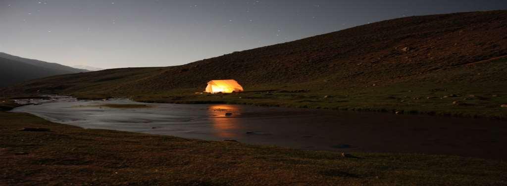
47 ADVENTURE IN HIMACHAL
48 Trekking in Himachal Himachal provides with a fantastic trekking experience ranging from 1600 mtr to 6000 mtr in terms of altitude and terrain. There are 10 or more popular treks which one can take and enjoy beauty of Dhauladhar and Pir Panjal ranges. The routes over the passes between the Shimla region and the Kullu valley has numerous treks, apart from remote trekking in Trans-Himalyan regions of Kinnaur, Lahaul and Spiti. Pin Parvati Trek Pin Parvati trek is one of the most beautiful treks in Himachal Pradesh. This pass links Parvati Valley in Kullu with Pin Valley of Spiti. Hence it derives the name Pin Parvati Pass. There is no other trek in all over the Western Himalayan region, which can match the grandeur of Pin Parvati Trek. Sir Louis Dane, an Englishman first discovered this high pass trek in 1884 as entry point to Spiti from Kullu valley. This is a very difficult trek owing to its high in altitude and remains under snowfall for most of the year and terrain. Trek days: 12 days Total days: 14 days Highlight: Pin Parvati pass at 17,500 feet Grade: Difficult Season: June to October Hampta Pass Chandratal This is one of the fascinating treks as one would see changing vistas from greenery to partial trans- Himalayan barrenness. Kullu- Manali valleys are green while Lahaul has rain-shadows but barren landscape offering a fantastic treat to the eyes. Finally you drop down to Chandratal lake which would keep you captivated with beauty as we pitch tents and stay there for the night and day. Hampta Pass..(Cont). The trek starts from Preni village situated at height of 6370 ft. and you reach Baralacha La at 16,020 ft and Hampta at 14,000 ft thus reaching Chandratal. Trek days: 6 days Total days: 7 days Highlight: Hampta Pass at 14,000 ft. Baralacha La at 16,1010 feet and Chandratal Grade: Moderate Season: May to October except for July and mid-sept due to rains. Sar Pass Trek This is a moderate trek in Parvati valley of Himachal. Sar, in local dialect, means a lake. Sar valley overlooks the beautiful Parvati valley abundant in natural treasure. The valley is surrounded by snow clad mountains, perennial streams, waterfalls, and lush green forests. It is a heavenly experience for any adventurous traveler and nature lovers. It is recommended that Kasol be made the base camp for this trek. It is a lovely place, with its temperate climate and beautiful, elegant pine forests. Trek days: 5 days Total days: 7 days Highlight: Parvati Valley and Sar Valley Grade: Easy Season: June to October Kinnaur Kaisash Trek The Kinnaur Kailash range lies on the south of district of Kinnaur,which is dominated by Kinnaur Kailash (6349 mts) and Jonkarden (6437 mts). Kinnaur Kailash Peak is one the 5 Mount Kailash. It is believed that the Lord Shiva took care and regulated the universe from here. Earlier the parikrama used to be of 200 kms, but it has been shortened up. Kinner Kailash (cont). To reach this lost land, India's northern tip, in summers; you have to travel through the Hindustan - Tibet highway, the ancient silk route following the Satluj, the natural boundary between India and Tibet (China). The circuit attracts the a lot of pilgrimages. The holy parikrama starts from Kalpa via Triung Valley and then back to Kalpa via Sangla. From here, once can cross to Charang Ghati to complete the circuit around this range whose highest peak is Jorkanden at ft. Trek days: 7 days Total days: 9 days Highlight: Kinnaur Kailash parikrama, Charang Ghanti at 17,600 feet. Grade: Difficult especially crossing the pass. Season: mid-june to October White River Rafting in Himachal Himachal provides an awesome environment and place for white river rafting. Rafting points are: 1. Kullu for Byas river 2. Shimla for Sutlej river 3. Parvati river at Manikaran 4. Chandra river at Spiti Himachal tourism corporation also conduts courses for river rafting and could be enrolled while at any of these places. Paragliding in Himachal In Solnag Valley, one could experience adernaline rush by selecting paragliding during summer months of May to October. There are various sports associated with paragliding and one could register while at Solang Valley. During winter months of November to March, Solang valley is known for skating and skiying and this also could be enjoyed here.

49 MOTOR BIKE TOUR OF SPITI VALLEY From June end to October end, the Himachal provides an awesome opportunity. To drive from Manali to Leh or take Shimla to Kaza, Spiti which is equally daunting and challenging as once traverses Hindustan-Tibet road which was earlier silk route from India to China. In my earlier section, covered on Manali to Leh and now I m sharing experience on Shimla to Kaza and back to Shimla & Chandigarh. Our journey begins with reaching Chandigarh on our own while Himalayan Fantasy staff arrive from Shimla to meet up with us with the bikes Some of my friends had their bikes shipped, while I wanted to drive Enfield 500cc bike from Chandigarh provided by the staff rather than taking my own Our bikes had arrived two days back and were stationed at Chandigarh Chandigarh 2. Shimla 3. Bikes We started from Delhi by boarding the train and reaching Chandigarh in just 4 hours. The next stop would have been Kalka where one can take the toy train from Kalka to Shimla. That is an aweesome experience for the family and now that we all were forced bachelors our bikes were much more than the wife content. Anyways, our bikes were getting ready while we had lunch and inspecting our bikes.we were briefed about next few days and then we started to Shimla to reach by evening Bushahr palace 2. Shrikhand peak 3. Saharan Today, we were to drive to Sarahan situated at 2315 m / 7640 ft- 175 kms in around 6 hours time. I was informed that the route is breathtaking and we were all very excited. After breakfast it s time to kickoff and we started motorcycle journey into Kinnaur. From Shimla riding up the Hindustan-Tibet Highway (NH-22) towards Rampur was a fantastic experience to begin with. This is because we are on oldest highway connecting to Tibet First pit stop was at ancient sun temple at Nirath a small town on the highway. At Jeori we took deviation and continued 18 Km winding up the mountains to Sarahan, home to the legendary Bhimakali temple, dedicated to the mother goddess Bhimakali, presiding deity of the rulers of former Bushahr State. Sarahan is a sleepy town is situated at 7101 ft. In Puranas, Sarahan is called as Shonitpur where the ruling king Banasur s daughter fell in love with Krishna s grandson Anirudha,.From here one can clearly see Shrikhand peak which is very good to look at.
50 Sutlej river 2. Baspa valley 3. Sangla Sarahan Sangla. (3450 m / ft) (100 KMS / 3 4 hrs) We were briefed that the ride is going to be short but challenging due to elevation and road conditions. Back-tracking till Jeori, we rejoined NH-22 again towards Kinnaur. Riding along the fierce Sutlej river flowing angrily in the gorges below we reached Karchham. At this turning point, a road continued towards Spiti and another turned towards the Baspa Valley and on to the beautiful village of Sangla. This was another 18 km stretch of narrow winding road with hair-raising gorges & cliffs high above the Baspa river gushing below.here was our stop and spot for staying for night. The gushing river sound was enchanting and so the mountain views Chitkul 2. Kalpa 3. RecongPeo This morning, after breakfast we were to start to Chitkul which is extremely beautiful village to look at and visit the last village before touching Tibet and overlooking Kinnaur ranges.we started our journey and the route itself was so exotic that we were finding it hard to continue our journey as we clicked photos in glory and stopping everywhere instead of riding. After enjoying a quite morning in the lap of Sangla valley we reached Chitkul and reached the border beyond which is Tibet in China. After spending considerable amount of time here we returned back to Sangla for lunch and by 3 pm we headed towards Kalpa. Again backtracking to the NH-22 at Karchham we continued on the road towards RecongPeo, nestled 7 km above which is the village of Kalpa Nako lake 2. Lake and village 3. Nako village After a nice sleep and the best morning we could ever image, we started our journey to Nako Lake situated at 3662 m / ft at a distance of 115 kms. Our guide said that it would take us around 4 hours and with numerous stops we did previous day, can be 5 hours also.!!!. As we ride further up the Hindustan-Tibet highway, the mountain landscape started to change from green to rocky & barren. Still riding along the Sutlej we reached a small hamlet called Spello our your permits were verified at a Police check-post. Another 35 km ride from there we reached Khab, a small village at the confluence of the Spiti& Sutlej rivers. Leaving Sutlej, from this point on we started riding along the Spiti river to reach Nako, a village situated near the small but beautiful Nako lake (3660 M). This is first of the many high altitude lakes visited by us on this tour. The location of this village is very remote & infrastructure is basic including food Tabo 2. Dhankhar 3. Spiti Gate Nako Tabo Dhankhar Kaza (3600 m / ft) (150 KMS / 5 6 HRS). Today s ride will take us further up into higher mountains (& across the infamous MalingNala, our first major water crossing) and down to Chango where we shall enter Spiti Valley. We will visit the Tabo Monastery. After having lunch at a restaurant nearby we started our dirve further to Dhankhar, the ancient palace of Spiti on the top of the cliff after visiting the Palace there we started our ride further to Kaza which is district headquarter of Spiti. This spelndid journy is what we signed up for. Spiti valley is amazing is to see from the landscape to culture. Spiti in local language menas middle country and has more affinity towards Tibet and you can see Tibetan Buddhism to all its glory from Tabo to Dhankhar monastery.
51 Kibber 2. Dhankhar 3. Kibber village The morning was exceedingly good with blue sky and mountain vistas towering. Kaza is one good place bu then road is real challenging especially with the slippery tracks. But that adds lot of fun and adventure. We started our ride to visit Ki Monastery & Kibber village situated at a height of 4205 M / FT the highest situated village which is connected by motorable road. The views from the monastery is exceedingly beautiful and breathtaking. One will forget himself in this environment and with the sound of chymbals and prayer flags fluttering across the horizon. We stayed there for more than 3 hours or more trying to understand nuainces of Tibetan Buddhism. Again the effort by Himalayan Fantasy folks in explaining us the place and documentaiton came real handy. It made us wonder on the amount of information the company has and provided to us fo r the benefit of everyone. From Ki Monastery we proceeded to Kibber Village and monastery. Later in the afternoon, it was time to start back to Kaza and stay for the day and enjoy the night Kumzum La 2. Chandra Tal 3. Chandra Tal Today was the most fascinating point of our entire bike trour of Himachal. We were to touch Kunzum La at 15,020 feet and Chandratal at 14,090 feet with a travel of 100 kms to be completed in 4 hours. Continuing up the Spiti Valley & further into higher Himalayas, after a adventurous journey we arrived at fascinating Kunzum La, 4550 m.. After passing through a couple of streams (glacier melts) we reached the beautiful & desolate lake of Chandra Tal (4270 m). A chilling yet intriguing experience, nevertheless Lady of Keylong Rohtang Traffic Before Rohtnag As our journey was coming to end, we were updated that from Chandra tal to Manali would take anywhere between 6-12 hours depending upon the road conditions and traffic. We planned to start by 7:30 am, but then everyone were tired of previous day trecherous journey that we started by 9:00 AM. To our horrific sight, traffic jam started just 30 kms after pasing Spiti onto Lahaul valley. Reaching Keyong was seeming like a distant dream Eventhough the kms from Chandratal to Manali was just 150 kms, it was seeming like we reach Manali by evening.after 4 hours of wait and driving, we reached Rohtang Pass. Traffic pile up was an amazing sight there and we stood for more than 2 hours before we started to move. By 3 pm, traffic eased and we reached Solang Valley by 4:30 pm and then Vashist spring in.manali by 5:30 pm. We checked into hotel at 6:00 pm and were dead tired by then Today is our last day of riding. We started from Manali to Gushaini. This is a small yet beautiful village and need to cross Tirthan river to go over to other side. The stay was wonderful at Raju Guest house. More information on Guest house can be found on internet. Tirthan river is known for wily trout fishing and you can try to fish. If one does not like fishing, can then just relax. Today, was reserved for taking rest and fun at Gushaini. Crossing Tirthan Raju cottage Before Rohtnag Day 11: We started back to Chandigarh and the bikes were already given back when we reached Gushaini. After 4 hours of travel, we reached Chandigarh and onto high speed train to Delhi. Next day we took early morning flight ack to Bangalore with 6 of our friends.it was indeed a fascinating experience like never before. Once again thanks to Himalayan Fantasy staff for makiing this tour possible especially the bikes were of high quality be it 350cc or 500cc.
52 Himachal Best time to visit Shimla-Manali-Kullu Kangra Valley since the terrain is very vast; you will find variations in temperature. The suggested period are: April to Oct Perfect holiday experience Nov-Mar : Winter experience with snow Lahaul and Spiti Dist: July to October. Beyond October, the passes closes at Rothang and hence cannot visit. Climate condition Arid and tundra. Snow from November to March. Other months would be pleasant. Temperature Entire Himachal Pleasant Moderate May ~ Sept April and Oct Very cold. freezing : Nov ~ March Mobile phones Postpaid Private and BSNL works in towns like Manali, Kullu and Shimla. Better to have BSNL mobile. For detailed itineraries, please visit: All our tours are customizable and hence the itineraries are just suggestive. Do call us for customizing as per your needs.


53 SIKKIM AND DARJEELING Sikkim Is known as Scotland of East. Sandwiched between the kingdoms of Nepal in the west and Bhutan in the east, lies a small stretch of rugged land just 11 5kms and 65 kms is Indian State of Sikkim. This is one of the cleanest state of India. Darjeeling is tucked away between Sikkim in South, Nepal in the West and Bhutan in the East. Being part of West Bengal, however, Darjeeling shares the same topography of Sikkim and major language is Nepali as it was earlier part of Nepal before Indo-Nepalese war.
54 BRIEF HISTORY Sikkim though the smallest state in India, yet is one of the cleanest and beautiful. It has diverse history, culture and legends associated on how this place came into existence. Landlocked between Nepal, Bhutan and West Bengal, this State has different kind of climate at each regions except for scorching summer. Almost 2/3 of the State is covered by mountain ranges towering over 20,000 feet and the Sinolchu mountain is considered as the most beautiful apart from the Five Jewel mountain which is Kanchendzonga. The earliest inhabitants known to have settled are a tribe by name Lepcha s (Ravine Folks) who arrived somewhere in thirteenth century and were from Assam and Bhutan. They too followed Bon faith like Tibetans until advent of Buddhism. During 14 th century, Bhutia s (Bhot in Nepalese means Tibetans) settled here and established Sakya kingdom.guru Tashi was inspired by a divine vision to establish his kingdom here for the welfare of the people. Sakya ruled for more than 200 years and during which period Buddhism became predominant as a religion of Sikkim and monasteries were constructed. During 1600 AD, there were disturbances in Tibet where Red Hat sect people had various hardships to deal through. They fled to Sikkim and Bhutan in order to escape persecution. During 1642, Phuentshok along with his family travelled to Yuksom (Norbugang) and became the first king or Chogyal (Chogyal means Righteous Ruler) taking the surname Namgyal. Under his regime, Sikkim expanded to include Chumbi valley in Tibet, Darjeeling, Kalimpong and parts of Nepal and Bhutan. The capital was Norbugang or present day Yuksom and term Sikkim was first used. Sikkim means Su Khim or New House. Around 1670, his son shifted the capital to Rabdentse near the Pemayangtse Monastery in Pelling. Today, you can see the Rabdentse palace in ruins when one visits Pelling. After few years, family schism during generations of rule, invited Bhutanese to invade Sikkim who took Rabdentse and Kalimpong. The monarchy was restored but during Tenzing Namgyal rule, Nepal invaded Sikkim and drove him out of Rabdentse and he fled to Tibet. Nepalese being over ambitious wanted to conquer Tibet but then Chinese forces subdued their attack and restored back monarchy of Sikkim. Since then, Sikkim was a vassal state of China. Following the beginning of British rule in neighboring India, Sikkim allied with Britain against their common adversary, Nepal. The Nepalese attacked Sikkim, overrunning most of the region including the Terai. This prompted the British East India Company to attack Nepal, resulting in the Gurkha War of 1814.Treaties signed between Sikkim and Nepal resulted in the return of the territory annexed by the Nepalese in However, ties between Sikkim and the British weakened when the latter began taxation of the Morang region. In 1849, two British physicians, Sir Joseph Dalton Hooker and Dr. Archibald Campbell, the latter being in charge of relations between the British and Sikkimese governments, ventured into the mountains of Sikkim unannounced and unauthorized The doctors were detained by the Sikkimese government, leading to a punitive British expedition against the kingdom, after which the Darjeeling district and Morang were annexed to British India in The invasion led to the Chogyal of Sikkim becoming a titular ruler under the directive of the British governor. In 1890, Sikkim became a British protectorate, and was gradually granted more sovereignty over the next three decades. In 1947, when India became independent, a popular vote rejected Sikkim's joining the Indian Union. Although a treaty was made between India and Sikkim in 1950, in the interest of Prime Minister Jawaharlal Nehru. That Indo-Sikkim treaty made Sikkim an Indian protectorate status. Sikkim came under the suzerainty of India, which controlled its external affairs, defense, diplomacy and communications, but Sikkim otherwise retained administrative autonomy. A state council was established in 1953 to allow for constitutional government under the Chogyal. Meanwhile, the Sikkim National Congress demanded fresh elections and greater representation for Nepalis in Sikkim. Palden Thondup Namgyal, the Chogyal at the time, proved to be extremely unpopular with the people, and in 1973, riots in front of the Chogyal's palace led to a formal request for protection from India. In 1975, the Prime Minister of Sikkim appealed to the Indian Parliament for Sikkim to become a state of India. In April of that year, the Indian Army took over the city of Gangtok and disarmed the Chogyal's palace guards. Thereafter, a referendum was held in which 97.5 per cent of voters supported abolishing the monarchy, effectively approving union with India. Although the union was presented as the will of the people by the India authority, the merger was widely criticized as an annexation and India was accused of exploiting the ethnic divide and rigging the referendum. On 16 May 1975, Sikkim became the 22nd state of the Indian Union, and the monarchy was abolished. As of date, Sikkim is cleanest and prosperous state of India.
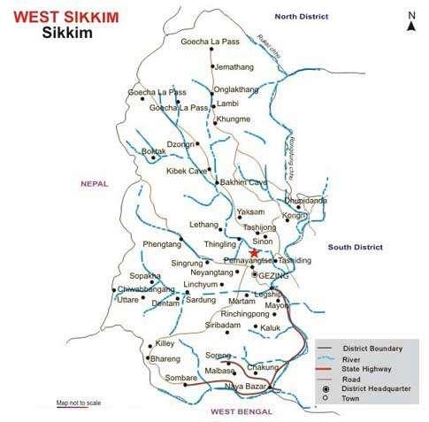

55
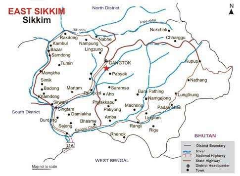
56
57 West Sikkim Yuksom Yuksom in West District of Sikkim was the capital of Namgyal as indicated earlier in the brief history. Here is what you can see while at Yuksom 1. Kongri Labdang Situated at a distance of 25 kms. from Pelling, it is considered to be one of the sacred lakes of the State both by the Buddhist and the Hindus. The Lake remains hidden under the rich forest cover. The birds do not permit even a single leaf to float on the lake surface. There is motorable road from Pemayangtse right up to the lake area. 2. Dubdi Monastery This was the first monastery established soon after the consecration ceremony of the first Chogyal. The monastery is located on a hill top above Yuksom surrounded by verdant forest. It can be approached by trekking only, negotiating steep slope for about half an hour. It is an ideal place for lamas seeking meditation recluse. 3. Phamrong Waterfalls Located between Yuksom and Gerethang this highest waterfall of West Sikkim presents a magnificent scenario especially during Monsoon. A gentle gradient footpath takes one to a viewpoint for a closer view of this mighty discharge of water. A cafeteria is being constructed for the benefit of tourists and the picnickers. 4. Tashiding Monastery This monastery is constructed on top of a heart shaped hill with the back drop of the sacred Mt. Khangchendzonga. According to Buddhist scriptures Guru Padmasambhava, blessed the sacred land of Sikkim in the 8th century AD from this spot. The monastery, however, was built in the 18th Century AD by Ngadak Sempa Chempo, one of the three Lamas who had performed the consecration ceremony of the first Chogyal. Soreng Drive from Pelling in west Sikkim takes you to the picturesque village of Soreng. Surrounded by lush green hills, Soreng is located amidst scenic splendour. The area is famous for the wide variety of flowers and birds available here. A trip to Jhandi Danra is highly recommended for nature lovers. Soreng is one of the three gateways to the Barsey Rhododendron Sanctuary. Sandwiched between the Singalila National Park in the south and Khangchendzonga Biosphere Reserve in the north, this small 104- sq-km sanctuary is at an altitude of 10,000 ft and supports a wide variety of bio-diversity. But the main attraction of the sanctuary is the rhododendron which blooms in April- May. Chakung A picnic spot, cafeteria, easy walking trail through forest, Durpiney Danra Viewpoint (also a paragliding takeoff point) overlooking Darjeeling, Jorethang etc. are worth a visit. Tourists can easily spend a day in these eco-friendly surroundings. Varey Near Hilley, in West Sikkim is the Varsey Rhododendron Sanctuary. Sandwiched between the Singalila National Park in the south and Khangchendzonga Biosphere Reserve in the north, this small 104- sq-km sanctuary is at an altitude of 10,000 ft and supports a wide variety of bio-diversity. But the main attractions of the sanctuary are the rhododendrons which bloom in April- May coloring the Sanctuary in wild abandon. Legship Often called the Gateway to West Sikkim, Legship is slowly gaining in popularity. On the left banks of the river Rangit is a Shiva temple known as the Kirateshwar Mahadev Mandir. 4 kms from here, close to Reshi is the very popular Phur Cha-chu sulphur baths. This hot water spring is well known for its medicinal properties. Legship cont Close by is Kah-do Sang phu or the cave of the occult fairies considered sacred by the people. Rangit Water World, a lake formed by the Rangit dam offers swimming, angling and river rafting facilities. Tashiding Tashiding is a small village on a hilltop near Pelling. The Tashiding monastery belongs to the Nyingmapa order and is highly revered among the people of Sikkim. Build on the top of the hill and looming over the Rathong and Rangit river, the monastery can be seen from far and wide. It is believed that even a slight glimpse of the monastery can cleanse mortals of all sins. The monastery was built during the 17th Century. There are a large number of oranges orchards and cardamoms plantations around Tashiding which can be visited from here. Inside the monastery, a pot of holy water is kept sealed only to be revealed and its droplets given to devotees once every year at the Bumchu Festival during the 14th and 15th day of the first month of the Tibetan calendar. Situated in the west district of Sikkim, you can reach Uttarey from Pelling, Gezing or Dentum. On your way you will pass Singsor bridge, said to be the second highest bridge in Asia. The height of Uttarey is about 6600ft. Uttarey Uttarey is famous for its tranquility and natural beauty. The place provides beautiful view to the Himalayan mountains and is yet relatively less traveled by tourists. This allows a more serene atmosphere to be enjoyed. During winter the mountains around here are covered with snow allowing heavenly views. The Kagju Gumpha (Gumpha is the local for monastery) in Uttarey is a highly revered place of worship for the locals and a good place for sight seeing.
58 Uttarey (Cont) The monastery is set amidst dense forests. The wall paintings in the monastery might be of interest to you. The Dentam peak and the river is also visible from the monastery. Other important tourist spots around Uttare include the Mainbus Waterfall and the Chewyabhang Pass. This pass is about 10 km of Uttarey and is the gateway to Nepal. Rinchenpong The upcoming tourist spot in the western part of Sikkim, has a magnificent command over the mountain views, sunrise and sunset, flora and fauna, village tourism,historical sites and heritage of Resum Monastery, rich forests and ample area for short treks. At an altitude of about 5576ft, Rinchenpong is the latest addition to the tourist map of West Sikkim. The place is famous for the beautiful view of the Kanchenjunga range of mountains. Apart from the natural beauty of the surroundings, the place is also quite significant from historical point of view. Gyalshing The headquarters of the West district, Gyalshing, which means the King s Garden, is believed to have once been the royal gardens attached to the Palace at Rabdentse, Sikkim s capital till the late 18th century. Today it is a bustling town and the main transit point to various tourist destinations of the region. Close by is Rabdentse as well as Pemayangste, Sikkim s premier monastery. Opposite Gyalshing bazaar is the longest and believed to be the holiest, Mendang or Holy Wall, constructed by the third king, Chogyal Chador Namgyal. Gyalshing Bazar, is one of the oldest market established approximately about 100 years ago Sombaria Situated at an altitude of 3,700 feet, Sombaria, a small village is full of vegetation of temperate type and is located remotely in the extreme Western Sikkim. Sombaria is close to the Indo-Nepal border and border region of Darjeeling Hills. At a distance of 115 km away from Siliguri and 112 km from the capital city of Sikkim, Gangtok, it is an ideal place for Bird Watching.. Pelling Around 10 kms from Gyalshing (District Headquarter), Pelling is today emerging as the second biggest tourist destination in the state after Gangtok. Although in itself it is little more than a strip of road lined with hotels, its main USP is the breathtaking view it offers of the Khangchendzonga and surrounding ranges, as well as the easy access it provides to tourist spots in the area. Pemayangste monastery is less than a kilometre from Pelling, while a 40 minute walk on the hill opposite the monastery takes you to Sanga Choling monastery built in 1697, one of the first in the state. Pelling s serene environment and picturesque setting is perfect for nice nature walks and small treks. A destination for all seasons, Pelling has hotels and resorts catering to all budgets. Khecheopalri Lake Khecheopalri Lake Situated at a distance of 25 kms. from Pelling, it is considered to be one of the sacred lakes of the State both by the Buddhist and the Hindus. The Lake remains hidden under the rich forest cover. The birds do not permit even a single leaf to float on the lake surface. Pemayangste Monastery It is one of the oldest monasteries of the State. It was originally established by Lhatsun Chempo, one of the revered Lamas to have performed the consecration ceremony of the first Chogyal (Monarch) of Sikkim Hee Bermoik Journey to Hee Bermiok takes about four and a half hours from Gangtok. One can also reach here from Pelling, the journey taking one and a half hours. The main attractions are mountain biking, nature walk, visit to villages, Sirijonga Yuma Mangheem, Sirijonga Holy Cave at Martam etc. The adventure lovers can enjoy two and a half hour trek to Varsey. Apart from having an annual tourist festival, village home stay facilities are available. These are being further developed and upgraded with the help of INTACH, New Delhi. SRIJONGA YUMA MAGHEEM, MARTAM This Limboo temple was constructed at Martam in in West Sikkim, in the memory of Siri Jonga-Tey- Ongshi. His birthday is celebrated on a large scale in the month of December every year by the Limboo community, known for their ancient language, heritage, culture patterns and boom of their Chabrung. In addition, a Lomboo Culture Centre set up at Tharpu in 2003 depicts their rich culture. Wadhan (Cave) Upon undertaking a 2 kms trek from from Sirijonga Yuma Mangheem, one comes across a waterfall besides which lies a cave where Teongshi is reported to have taken refuge. This place is reserved by the Limboo Community. Dentam DentamDentam is a scenic village located 10 km from Varsey in West Sikkim District. It lies at an elevation of around 1,500 m. Dentam commands a constant view of the Kanchenjunga. The entire area is surrounded by forest of rhododendrons. Pemayangtse Monastery (10 km), Ravangla (69 km) and Hilley are nearby interesting destinations to visit. The village is an ideal spot for bird watchers and nature lovers. Trekking and mountaineering are arranged here. Accommodation is available at Pelling and Pemayangtse.
59 South Sikkim South Sikkim is known for culture and in recent past for Char Dham and Samdruptse Monastery. Here are list of places which should not be missed. Namchi 78 kms from Gangtok, Namchi, literally translating as top of the sky is the South district headquarters and fast emerging as a tourist destination. Set in a picturesque location, Namchi offers an unmatched view of the Khangchendzonga range and the Rangit valley. Here are few things you can do at Namchi. 1. Rock Garden. Around two kms from Namchi is the old Ngadak monastery which is now being renovated. Situated on a hill just above Ngadak monastery is the very attractive Rock Garden, which is full of rare flowers and plants and also offers breathtakingly beautiful views. 2. Samdrupste Samdruptse literally means 'wish fulfilling hill' in the Bhutia language. Situated near Namchi in South Sikkim, it is at a distance of 75 kms from Gangtok. A unique, awe inspiring and gigangtic 135 feet high statue of Guru Padamasambhava is installed atop Sampruptse. It is the highest statue of Guru Padamasambhava in the world. His Holiness the Dalai Lama laid the foundation stone of the statue in October It took nearly three years to complete the statue. 3. Solophok Chardham Sikkim Govt in the recent past took a task of promoting Sikkim as Eco tourism and Religious village and thus started construction fo Chardham which has following unique structure: a. Shiva statue measuring 87 feet. b. 12 Jyotir Lingas c. Replicas of these four Dhams, namely Badrinath, Jaganath and Dwarka dedicated to Lord Vishnu and Rameshwar, dedicated to Lord Shiva is also constructed. Ravangla Ravangla is one of the most popular tourist destinations in South Sikkim. At an altitude of 7000 ft, located on a ridge between Maenam and Tendong Hill, Ravangla offers unmatched views of the Greater Himalayas. 8 kms on way to Damthang is the Rayong sunrise view point that offers spectacular views of the first rays of the sun falling on snow peaks. Visit the Ralong monastery as well as the Tibetan Carpet Centre. The traditionally designed and woven carpets available here are said to be the best you can buy anywhere. Some of the best places to vist neear Ravangla are: 1. Borong Facing the snow-capped mountains is Borong, motorable from Ravangla or by a trek via Maenam. A picturesque village, its beautiful landscape and magnificent view is also host to the hot spring, 'Borong Tsachu'. The trek trail, originating from Namchi or Damthang to Tendong - Ravangla Maenam - Borong (5-6 days) is one of the most interesting trails scaling all the hill tops along the route. The trekker can continue to Tashiding or terminate at Borong and then drive back to Ravangla. 2. Borong and Ralong Hot Springs Borong and Ralong hot water springs are located within a distance of 7 kms from each other. Popular with visitors from all over the region, these natural spas are said to have strong curative powers. Ralang Cha-chu can be reached after an hour long walk from Ralong monastery while Borang Chachu is reached after a 7 km drive to Ralong and then a 40 min walk downhill. 3. Buddha Park (Sakyamuni Project), Rabong To commemorate the 2550th year work is in full swing to construct and install statue of Lord Buddha at Rabong and also to develop the Buddhist Circuit in Sikkim Ravangla (Cont) 4. Kewzing Village Eight kms from Ravangla is Kewzing Village which offers the opportunity of experiencing the rural life in Sikkim. You can stay here with a local family in village home stays and experience the warmth of Sikkimese hospitality. The Bon Monastery here is the only one of its kind in Sikkim and is a symbol of the determination of a community to preserve their religious traditions. Located 2 kms from Kewzing bazaar is the Mangbrue Gompa, which follows the Nyingmapa sect of buddhism. 5. Maenam Hill Maenam Hill Situated at an altitude of 10,300 ft the scenic view from this height is, perhaps, unmatched in this part of the world. Mt. KhangchenDzonga and its surrounding ranges loom above to dwarf the richly forested and rugged hills. On a clear sunny day, it is possible to see the plains of Bengal spanning across Kalimpong and Darjeeling hills in the South and right across the Indo-China border towards the North. 6. Temi Tea Estates The one and only tea estate existing in the State produces one of the top quality teas for the international market. The tea garden spread out on a gentle hill slope originating from the Tendong Hill provides a magnificent view of the surrounding villages. The visit to the factory could be an eye opener for those wanting to know about tea processing methods. 7. Tinkitam Is the natural habitat of a rare species of orchid, Paphiopedilum Faireanum or ladys slipper as it is commonly known. Unlike most wild orchids which grow on trees, this orchid is terrestrial and flowers in October- November. Also this is the home town of Indian Soccer captain, Baichung Bhutia.
60 Jorethang Situated at an altitude of 300 m above sea level with a pleasant temperate climate is Jorethang, a major town in south Sikkim. It lies sprawled upon the foothills below which flows the Rangeet River, with the hills of Darjeeling looming large in the south on the opposite side of the river. East Sikkim To the East lies Gangtok which itself has plenty of places to see and is one of the cleanest towns of India. From here once can visit the ONLY International Border to China where you can shake hands with Chinese at NathuLa Pass. Most fascinating places in East Sikkim are: Gangtok Gangtok, the capital city of Sikkim is located on a ridge at a height of 5500 feet. With a spectacular view of the Khangchendzonga, the town provides the perfect base for travel through the state. Once an important transit point for traders traveling between Tibet and India, it is today a busy administrative and business centre and presents an interesting mix of cultures and communities. 1.Harbajan Singh Mandir The temple lies on the road between the Nathula and the Jelepla Pass and is visited by hundreds of people each day. The temple is believed to have wish-fulfilling powers and many devotees leave behind bottles of water at the temple which they pick up on their way back as holy water. On Sundays a langar is run at the temple which provides free meals to the visitors. 2.Bakthang Waterfalls A small drive or a nice nature walk will take you to this waterfalls along the 31 A National Highway leading to North Sikkim. It originates from Ratey Chu, the main water source of Gangtok area. 3. Banjhakri Falls and Energy Park This beautiful places has Sikkim cultural show apart from Waterfalls, well laid out trails and amazing landscape. The main attraction of this place as culture is Shamanism where in people are believed to host spirits in their body and do various meta-physical activites which are normally not possible with a normal person. Many murals and Gazebos are placed on this practice and must see place when you are in Gangtok. 4. Do-Drul Chorten Do-Drul Chorten or Stupa was built by the Venerable Trullshi Rimpoche, head of the Nyingma order of Tibeten Buddhism, in Inside the stupa, there are complete mandala set of Dorjee phurba (Vajra Kilaya), a set of Kang Gyur relic (Holy Book), complete 'Zung' (mantras) and other religious objects. Around the Chorten, there are 108 Mani Lhakor (Prayer Wheels). These are turned by devout Buddhists while chanting 'Om Mane Padme Hum' (O Jewel in the Lotus) to invoke the Bodhisattva. It is surrounded by Chorten Lakhang and Guru Lakhang, where there are two huge statues of Guru Padmasambhava. 5. Enchey Monastery An important seat of the Nyingmapa order, the Enchey Monastery is built on the Site Blessed by Lama Druptok Karpo, a tantric master known for his power of flying. This 200 years old monastery has in its premises images of gods, goddesses and other religious objects. Every year around January, "Chaam" or religious masked dance is performed with great fanfare-for two days. 6. Fambong Lho Wildlife Sanctuary Located at a distance of 25 kms from Gangtok having an area of sq. km has oak, katus, kimbu, champa, thick bamboos and ferns. The sanctuary is also home to a large number of wild orchids, rhododendrons, etc. The richly forested area is known to be the home for various species of wild animals and birds. This area, located close to Gangtok, is also a short trekking trail. 7. Ganesh Tok From this Spot one can get birds eye view of sprawling Gangtok town, while across the hills Mt. Khang-chen- Dzonga and Mt. Siniolchu loom over the horizon. A cafeteria serves hot tea, coffee and snacks. The view from here is truly breathtaking with snow peaks providing the perfect backdrop for a panoramic view of Gangtok town. Dedicated to Lord Ganesh, the temple is located at an altitude of 6500 feet on a panoramic hilltop. At present the temple is surrounded by a beautiful pinetum, Bulbylay Zooligical Park and a smriti-van, wherein visitors plant saplings in the memory of their dear departed. 8. Hanuman Tok The temple dedicated to Lord Hanuman is situated at an altitude of 7200 feet at a distance of about nine kilometres uphill from Gangtok on a blissfully calm and quiet hilltop. Popularly known as a wish fulfilling temple, it is maintained by the resident units of the Indian Army and contributions from the local people. The whole complex has been recently renovated and a lot of public utilities provided. The location is completely free from the pollution of city life and provides spectacular view of Mt.Kanchendzonga, 9. Gangtok Ropeway It takes the passenger to the highest point of the city of Gangtok, covering the distance of about 1 km in only seven minutes. Each cabin accommodates 24 passengers. The lower terminal station is located at Deorali Market, the intermediate terminal at Nam- Nang and the upper terminal station is below the Secretariat (Tashiling). One can truly enjoy the panoramic view and thrilling rise as the Ropeway goes over the City.
61 10. Himalayan (Bulbuley) Zoological Park Himalayan (Bulbuley) Zoological Park 8 kms away from Gangtok is the Himalayan Zoological Park which covers an area of 205 hectares. This area is also known as Bulbulay. Located just above Ganesh Tok, the park is home to a number of animals living in open enclosures in their natural habitat. If you are lucky you might see the Red Panda, Sikkim s state animal, the barking Deer, Tibetan wolves, panthers, Civet cats or even the Himalayan Black Bear. The Park also has Kush and Urbashi, a snow leopard pair living in. It s definitely worth a visit. 11. Menmecho Lake Upon covering a distance of 64 kms from Gangtok via Sherathang (6 kms short of famous Nathula Pass) one comes across a marvellous snow fed water body called Menmecho Lake (altitude 13,000 feet). Surrounded by lush green forest and typical reddish alpine grass cover, it is the source of the river Rangpochu. Larger in size than Tsomgo lake, it is full of trout fish. Impressed by its calm and quiet atmosphere and rare beauty, one can spend hours in splendid isolation. 12. M.G. Marg The main street of Gangtok town is a great place to chill out in the evenings. The country's first litter and spit free zone, no vehicular traffic is allowed into the Marg. You can sit at the Titanic Park and listen to the piped in music played for the listening pleasure of visitors or just walk down the Mall and take in the carnival like atmosphere, especially during the tourist season. The Mall is lined with shops on both sides of the road so shopping becomes an added pleasure. 13. Tashi View Point Situated along the North Sikkim Highway, it is only 8 kms from Gangtok. From this point one gets a breath taking view of Mt. Khangchendzonga and has observatory and cafeteria. 14. The Ridge The Ridge, a small stretch of flat land above Gangtok town is one of the most attractive places here and is a favorite haunt for both tourists and locals. It stretches from the gates of the Palace of the erstwhile Namgyal kings to the White Hall building built in the memory of the first Political Officer of Sikkim, Claude White. 15. Sikkim Science Centre, Marchak The first of kind in the state, communicates science and technology in a non-formal way with the primary objective of developing a scientific temper and promoting creative learning among people at large, including the student community. Its galleries on Unique Human and Fun Science, Childrens Activity Corner, Science Park, Taramandal Show and various educational activities are step towards the aspired goal. 16. Tsogmo Lake 38 km from Gangtok and at an altitude of 12,400 ft, the ethereally beautiful Tsomgo lake is a must on every visitors itinerary. A winding road through rugged mountain terrain and sharp cliffs takes you to Tsomgo, which means source of the water in Bhutia language. The lake derives its water from the melting snows of the mountains surrounding the lake. Of legendary beauty, the lake looks different at different seasons. In winter the placid lake remains frozen with the area around it covered in snow while in late spring the profusion of flowers in bloom adds a riot of colours around the lake. 17. Nathula Pass Nathula Pass was a major corridor of passage between India and Tibet before it was closed in Located around 56 kms from Gangtok at an altitude of ft, the road to Nathula passes through the Tsomgo lake. It is one of the highest motorable roads in the world and is richly surrounded by alpine flora. On a clear day you can even see the road winding down the Chumbi valley. Tourists are allowed to go close to the international border from where you can see Chinese soldiers on the other side of the barbed wire. Nathula Nathula is open for Indian nationals on Wednesday, Thursday, Friday, Saturday and Sundays. 18. Elephant Lake Further ahead of Baba Harbajan Mandir on way out of Nathula, you will be amazed at a lake shaped like a Elephant. This is an out of bound place and need special permit to visit here. 19. Yak Golf Course and Environmental Park, Kupup This is one of the fascinating golf course which is highest in elevation in the world and has got Guniess Book of World record. Worth visiting this place while return from Elephant Lake, Nathula. 20. Saramsa Garden About 14 kms. from Gangtok is the Saramsa Garden. Established and maintained by the Department of Forests, it is an excellent recreation, leisure and picnic spot. A musical fountain and a swimming pool are the recent additions. The Garden is the venue for the International Flori Show Sa-Ngor Monastery It is a Tibeten refugee monastic institution established in 1961 by his Eminence Luding Khen Rimpoche, Head of Ngorpa, sub-set of the Sakya Order, with the blessings of H.H. Sakya Trizin and H.H. The Dalai Lama. This is the only monastery of the sakya Order of Tibeten Buddhism in Sikkim. It is located on a beautiful hill top at a distance of 5 kms from Gangtok town.
62 Aritar A breathtaking view of Khangchendzonga only adds to the many natural riches that Aritar is blessed with. Lush green forests, sweeping hills of paddy fields and placid lakes hidden inside deep forests makes it a perfect destination for those in search of nature trails and a serene holiday. The Lampokari Lake surrounded by lush greenery is considered one of the oldest in Sikkim. This lake has been recently provided with artificial embankment to facilitate boating, a first for Sikkim. A short trek leads you to Mankhim Dara, where a temple dedicated to the ethnic Rai community is located. Mankhim offers a 360 degree view of the surrounding areas. The Aritar Gumpa is one of the oldest monasteries in Sikkim belonging to the Karma Kagyu lineage order of Tibetan Buddhism. Rumtek Situated around 23 kms from Gangtok, in the hill facing Gangtok is Rumtek, a quiet getaway and home to the Rumtek Monastery, seat of His Holiness, The Gyalwa Karmapa of the Kargyu sect of Tibetan Buddhism. The drive to Rumtek snakes through typical Sikkimese villages and many paddy fields. The paddy fields resemble a green carpet from July to September and later in October-November, the entire place is a sight to behold with golden paddy swaying in the breeze. The lush green hilly terrain, a breathtaking topography and misty mountains makes Rumtek an ideal place for some quiet time. Rumtek offer a host of sightseeing opportunities. These include local sightseeing within Rumtek, one day tours to places around Rumtek, monastery tours and adventurous exploits such as white water rafting and trekking. The main attraction, however, is the Rumtek Monastery, seat of His Holiness the Gyalwa Karmapa of the Kargyu sect of Buddhism. Rumtek..(Cont) The largest monastery in Sikkim it demonstrates the best of Tibetan architecture and is an almost replica of the original monastery in Tsurpu intibet. The monastery houses some of the rarest Buddhist religious art objects found in the world and is also a world renowned centre for Kargyu teachings. North Sikkim North Sikkim is often called as Switzerland of East as you can find Alps like climate and mountain vistas. You will be amazed with flora, fauna and breathtaking view of mountains, streams and above all visiting starting point of India at Zero Point and Gurudongmar Lake at 17,110 feet. Here are the details of North Sikkim. 1. Mangan 67 kilometres from Gangtok, this small town is the district headquarters of the spectacular North district. It is an attractive place with good views and is a transit point to other destinations of the region. A three day music festival is held at Mangan in December every year. Bands from the region as well as from the other Northeast states entertain the huge gathering and compete for the main prize. Mountains, music and the cold weather create an enthralling event. Other attractions include an exhibition cum sale of local handicrafts, a presentation of traditional cultural songs and dances and a food festival. a. Rong Lungten Lee This replica of a Lepcha traditional house at Namprikdang, 8 kms away from Mangan, was inaugurated on It comprises of three rooms. The ceiling called 'PHAHONG' (attic) is used to store valuable items. This house is open to tourists, both foreigners and domestic throughout the year and visitors can admire the antique artifacts displayed. Namprikdang is situated at the confluence of two rivers - Kanaka and Teesta. Visitors will definitely admire the pristine beauty of the flora and fauna especially during the annual Namsoong festival. b. Sirijonga Yuma Mangheem Constructed in 1983, its designs are similar to that of Sirijonga Yuma Mangheem - Martam, (West Sikkim). During January, Maghey Sankranti is celebrated with enthusiasm and people of all communities from the neighbourhood hamlets come and partake in the celebrations. In recent years the festivity has gained so much popularity that people travel for hours to witness the cultural extravaganza organised over here. 2. Lachen At an altitude of 8500 ft Lachen is alluring in its simplicity. Not yet as big a tourist destination as Lachung, it retains a freshness which is very appealing. The village comprises of less than 200 houses, earlier inhabited only during winters by their owners who spend their summers on the alpine pastures bordering Tibet tending to their yaks. Lachen is the starting point for some of the most interesting treks in North Sikkim as well as the gateway to the holy Guru Dongmar and Tso Lhamu lakes. You can visit the Lachen Gompa here and sample the simple village life of the Lachenpas. a. Gurudongmar Lake Situated at a height of 17,800 feet, it is considered one the most sacred lakes by the Buddhists and Hindus alike. The beautiful and awe inspiring lake (190 kms from Gangtok) remains milky in colour throughout the year. According to a legend, since the lake used to remain frozen most of the year, it was not possible to use its water for drinking purposes. When the Guru Padmasambhava passed by, while returning from Tibet, the local residents are reported to have approached him for providing source of water. The Guru obliged. A portion of the lake touched by him does not freeze in extreme winter. Since water of the lake is considered sacred, visitors carry the 'blessed' water in bottles.
63 Lachen (Cont) b. Thangu Thangu, situated at an altitude of 13,500 ft. is about two hours drive from Lachen. It is a small village where the visitors usually acclimatize before they proceed to Guru-Dongmar Lake, Muguthang or Cho Lhamu (source of River Teesta Singhik A small and picturesque hamlet, Singhik is located around four kms away from Mangan. The popular Singhik View Point offers the most magnificent view of Mt. Khangchendzonga and Mt. Siniolchu. Surrounded by lush green hills, with the Teesta River flowing below it, Singhik is a great place to take a short break in before heading on to the other destinations of North Sikkim. Dzongu 70 kms away from Gangtok in North Sikkim is Dzongu, an area reserved for the Lepchas, the original inhabitants of Sikkim. Bordering the Kanchendzonga Biosphere Reserve and at an elevation ranging between 3000ft and 20,000ft above sea level, Dzongu still retains an air of exclusivity. The Lepcha Communities in Dzongu live in relative isolation from the outside world with their own traditional practice and believe. 30 minutes ahead of Dzongu is the Seven Sisters waterfall, seven waterfalls falling down cliffs amidst dense forests, it is a sight to behold. Dzongu is surrounded with panoramic views of Mt. Khangchendzonga and is particularly rich in flora and fauna. Dzongu offers a unique home-stay experience. You can stay with local families and experience the Lepcha lifestyle and cultural traditions amidst luxuriant landscape and spectacular mountain scenery.. You can go for village hikes, visit the rich cardamom fields or check out the cane bamboo bridge at Passingdon. Go angling on the Teesta River or learn how the Lepchas use medicinal plants for healing. In the evening a special cultural programme can be arranged on demand. Dzongu offers an authentic and alluring experience of Sikkim Phodong Around 38 kms from Gangtok are the monasteries of Phodong, Phensang and Labrang. All three are close to each other on the North Sikkim Highway. Kabi 20 kms from Gangtok, on way to North Sikkim is the sacred spot of Kabi where the pact of blood brotherhood was sworn between the Lepchas and the Bhutias in the 15th century. Nine stones were erected facing Mount Khangchendzonga to witness the treaty of brotherhood between the Lepchas and the Bhutias. To this day the stones stand as testimony to the treaty. The area is a sacred grove rich with medicinal plants and is the venue for the annual Siqueok Puja, a thanksgiving for a good harvest to the Gods and prayers for continued benevolence. Lachung The picturesque mountain village of Lachung, at a height of 8610 ft, embraced by snow capped mountain peaks, breathtaking waterfalls, sparkling streams and apple orchards is the perfect holiday destination. Sprawled across the banks of the Lachung Chu [river] which slices the village in two, Lachung is famous for its apples, peaches and apricots. At Lachung you can visit the Lachung Gompa, built around 1880, the monastery is situated amidst apple orchards across the river from the town centre. Also go see the handicraft centre which has exquisitely woven rugs and blankets. Shingba Rhododendron Sanctuary Spread over 43 sq kms through which flows the Yumthang river, Shingba Rhododendron Sanctuary adjoins Lachung and Yumthang. The Sanctuary which is known for its abundance of Rhododendron shrubs and trees is rich in ground flora and other vegetation as well. The Yumthang River is rich in Brown Trout and good for angling. There is a forest rest house here as well as one in Yumthang. Yumthang Situated at a height of feet is popularly known as 'Valley of Flowers', Located at a distance of 148 kms from Gangtok, it is a paradise for nature lovers with a fascinating blend of flora and fauna and breathtaking scenic beauty. In spring season, wild flowers such as primulas and Rhododendrons bathe the landscape in rich colours, making it a tourist hot spot Yumesamdong Six kms away further North is Shiv Mandir. A drive or trek to this place can be very refreshing and exhilerating. Situated further up at a distance of 16 kms, at an altitude of about 16,000 feet is Yumesamdong where you can visit Zero Point or starting point of India. With office in Gangtok, we assist fellow travelers be it just a backpacker or a family on holiday or adventure enthusiast with all logistical arrangements from planning stage to completion of tour or adventure. Our itenerary is fully customizable to suit the needs of travelers interest, budget and time on hand. We provide off-beat, standard and all woman tours to this exotic land of Sikkim where you feel like coming back again and again.

64 Guru Padmasambhava at Samdrupste Elephant Lake, Nathula


65 Hanuman Tok, Gangtok 137 feet tall Buddha statue at Rabong


66 Char Dham, Solophok


67 India-China border at Nathu La, Pass Temi Tea Garden, Ravangla


68 Gurudongmar Lake, Lachen Lachen, Switzerland of East


69 Rabdantse Palace ruins, Pelling Cave in Legship
70 HISTORY OF DARJEELING Darjeeling or Dorjee-ling is derived from Tibetan word to say Thunderbolt place. Dorjee in Tibetan stands for Thunderbolt and Ling is place was part of Sikkim and was inhabited by Lepcha tribes. Sikkim ruler had always battles with Gorkha s of Nepal which were all the time unsuccessful. From 1780 the Gorkhas constantly made inroads into Sikkim and by the beginning of 19th Century, they had overrun Sikkim as far eastward as the Teesta and had conquered and annexed the Terai. E.C.Dozey in his 'Darjeeling Past and Present' writes, 'Prior to the year 1816, the whole of the territory known as British Sikkim belonged to Nepal, which won it by conquest'. In the meantime, the British were engaged in preventing the Gorkhas from overrunning the whole of the northern frontier. The Anglo-Nepal war broke out in 1814 where Gorkha s wree defeated. This led to the Treaty of Sugauli,in 1815 in which, 'Nepal had to cede all those' territories the Gorkhas had annexed from the Raja of Sikkim to the East India Company. 'In 1817, in the Treaty of Titalia', the East India Co. reinstated the Raja of Sikkim (who was driven out), restored all the tracts of land between the Mechi and the Teesta to the Raja and guaranteed his sovereignty. With the intervention of the British, the Gorkhas were prevented from turning the whole of Sikkim into a province of Nepal and Sikkim (including the present District of Darjeeling) was retained as a buffer state between Nepal, Bhutan and Tibet. Ten years later dispute once again arose between Sikkim and Nepal, which according to the Treaty of Titalia, were referred to the Governor General. Accordingly in 1828 Captain Lloyd was deputed to settle the dispute once and for all. Along with Mr. J.W.Grant, the Commercial Resident at Malda,he came to the Hills and was attracted by the position of Darjeeling as it was cloer to Tibet and Bhutan which Engish wanted to have trade links for all this long Some of the advantage were: 1. Serve as a British outpost in the Himalayas. 2. Serve as a base for the defence of the trade route to Tibet through Sikkim. 3. From its commanding height, the whole of Sikkim and the neighbourhood could be observed and protected. 4. A summer resort for British officials to escape the heat in the plains. Thus the Engish requested Raja of Sikkim to grant Darjeeling to them on lease which he could not deny. In the year 1835, the Raja gifted Darjeeling to British India for an annual grant of Rs This was an unconditional cessation of what was then a worthless uninhabited mountain. The land gifted to East India Co. in 1835 did not comprise the whole present Darjeeling. It was narrow enclave of 138 square miles, about 30 miles long and 6 miles wide. It was entirely surrounded by the Raja's dominions - entry and exit being restricted to a narrow path, which included the sites of Darjeeling and Kurseong towns and touched the plains near Pankhabari. What the Raja got in return immediately was a gift parcel - one double barreled gun, one rifle,one 20 yards of red-broad cloth, 2 pairs of shawl- one superior quality and the other of inferior quality. However, over the period, circumstances forced the Raja to give up Darjeeling to English. Also at this time, English looked at developing the place for Tea cultivation as it seemed conductive. After research, the forest areas were made way for tea bushes with the services of Chinese experts and Nepalese labourers. Darjeeling Tea thus got name of Champagne of East due to its unique taste. During the end of that century, they also discovered that some parts of Darjeeling area would best suit cultivation of Chinchona which was wonder drug for Malaria. Huge tracts at Mongpoo at approx 25 kms from Darjeeling was developed. English started working on railways to connect Bengal with Darjeeling for movement of goods and servies. This was commissioned in 1881 connecting Tindharia, Kurseong and Darjeeling. Further developments connected to Siliguri. Franklin Prestage also had plans to extend line over the Sinelila range to Arun valley in Nepal through Ilam district because he felt that the trade with Tibet through Nepal was more beneficial. However, the Nepal administration did not grant permission and was later dropped.
71 Darjeeling was in limelight right through 1900 as English also found this place to be best suited for surveying the himalayan ranges. Many of the major mountains were surveyed in Darjeeling and also reached pinnacle for Everest expeditions. Engish who were extremely observant found that the Nepalese locals having huge strength in carrying loads in hilly terrain thus prompting them to use as labor for Himalayan expeditions. During 1930 s there were many activites planned to conquer some of the mountains closer to Nepal and Tibet and Everest was the prominent. Tenzing Norgay or Namgyal Wangdi was a Nepalese resident who ran away from Nepal with a goal to achieve climbing highest peaks and when English met him for expeditions, he was taken as porter and then promoted to Sirdar or Chief. After India became Independent, Pt.Jawaharlal Nehru made Tenzing Norgay as the ambassador for mountainering activites in India and made him Director who established Himalayan Mountaineering Institute situated in Darjeeling. This institute even today is most sought out institution for acquiring skills in mountaineering and also get certified with Basic Mountaineer and Advanced Mountaineer. Today, Darjeeling is a bustling town filled with shops and hotels of every kind and a must visit place for soul stirring experience. MUST SEE IN DARJEELING 1. Chowrasta or Mall road What is Ride for Shimla is Chowrasta for Darjeeling. Situated above Darjeeling town is lined with shops and resturants of all kinds. Best place to chill around with the mighty Kanchendzonga rage in the East and rolling hills of Sikkim to the North. From here, one could stroll to see spectacular views of tea gardens apart from the awesome view of snow-clad mountains 2. Observatory Hill From Chowrasta, a few mintues walk you will reach Observatory hill on which you can see Mahakal temple. This shrine is of importance to both Buddhist and Hindus. 3. HMI Further down from Observatory Hill, you will reach Himalayan Mountaineering Institute which also has Padmaja Naidu Zoological Garden. On 4 th Nov, 1954 the then Prime Minster, Pt.Jawaharlal Nehru laid foundation stone of HMI which was chaired for many years by Tenzing Norgay after his successful summit experience of Everest. This place is known for entire mountaineering artifacts including the ones used by Edmund Hillary and Tenzing Norgay. 4. Himalayan Zoological Park Just adjacent to the HMI, you will find the zoo which houses variety of birds and animals like Red Panda, Bear, Snow Leopard, Antelopes and Tigers. These are related to Himalayan region and a good experience for both children and adults alike. This zoo is closed on Thursdays and opens up on all other days from 8:00 AM to 4 pm. 5. Darjeeling Ropeway This ropeway provides you with unique expereince of lifetime. From an elevation of 2,134 m (7,001 ft) in Darjeeling s North Point (Singamari), this bicable ropeway descended to 244 m (801 ft) at Singla on the banks of the Ramman river, which with Little Rangeet, meets the Great Rangeet. Stopping at Tukver, Burnesbeg and Singla tea estates, it takes 45 minutes to reach Singla Bazar, 8 km away. The ropeway passed over dense forests, mountain ridges, water falls, flowing rivers, green valleys and tea gardens. 6. Freedom fighter cottage (Step Aside) Just below Chowrasta, this beautiful cottage is where the famous Indian partriot and freedom fighter Deshbandhu Chittaranjan Das lived. The 1 st floor of cottages has ben retained as it was during the life of Deshbandhu. 7. Tibetan Self-Help Centre Again from Chowrasta, if one walks towards Lebong, will find Tibetan handicrafts centre which is a nice place to shop unique and authentic Tibetan wood carvings, carpets and woollens. You can also visit workshops to see how they are manufactured. 8. Natural History Muesum Further down on Chowrasta, you will reach National Hill Muesum which has wide range of collections of preserved reptiles, birds, butterflies and other insects. This is closed on Thursday like the Zoo and half day on Wednesday. The timings are 10:00 AM to 4:00 pm. 9. Japanese Peace Pagoda Around 2 kms from Chowrasta, you can visit Peace Pagoda which was constructed by Japanese in This is an awesome place to spend some quiet moments with the sound of the mystic peace mantra NA MU MYO REN GE KYO. 10. Dhiradham Temple This temple resembles the famous Pashupatinath Temple of Kathmandu is situated just below the railway station. This temple was built in 1939.
72 11. Rock Garden and Ganga Maya Park The Rock Garden is also known as the Barbotey Rock Garden which is located approxe 10kms away from Darjeeling town in a valley down below. Ganga Maya is another park area located further down. As you take the right turn from the main Hill Cart Road of Darjeeling towards the Rock Garden, you know that you are in for a nature's treat. The entire garden area has been created by cutting rocks at different levels and making terraced seating arrangements at various levels. There is a wonderful waterfall that comes all the way from the top and over the rocks to down below. You will need to keep climbing stairs, go up the ramp and cross small bridges across the rocks to reach up to the top. From the bottom, it's not possible to see the point where this water flow is entering the garden. The climb all the way up may be tiring for some. However, there are beautiful flower gardens, trees and shrubbery at all levels along with nice seating arrangements. So you can rest and relax, enjoy the views around as you go up. Ganga Maya Park is further down the road, about 3 kilometres (1.9 mi) from the Rock Garden. Named after an innocent victim of police firing during the GNLF agitation, it meanders down the course of a chortling mountain stream, past gazebos, clumps of flowering shrubs and trees, over humped backed bridges under which koi-carp coruscate, and into a circular lake with paddle boats and a waterfall. It has a small lake where boating facilities are available. Gorkha folk dances are performed to entertain the tourists. 12. Lloyds Botanical Garden A ten minute casual walk from Chowrasta near the taxi stand you will see this amazing botanical garden which consists of a wide range of flora like chestnut, ash, birch, magnolia and maple trees. Apart from that, you will see various orchids. Opens from 6 am to 5 pm. 13. Bhutia Busty Monastery Walking past Chowrasta in minutes near the Step Aside Cottage lies a monastery which was built as a branch of the Phodang monastery of Sikkim and was funded by Chogyal of Sikkim to build. A wonderful monastery indeed for those who want to know about Tibetan buddhism. 14. Ava Art Gallery On the way to Ghum from Chowrasta is the gallery of fine art and embroidery works of Mrs. Ava Devi is good to see before reaching Ghum for Yiga Choling Monasery. 15. Ghum Yiga Choling Gompa This monastery belonging to Gelugpa sect was built in 1875 by Lama Gyuantso and contains a 5 meter high statue of Maitreya Buddha. The lower portion of image made of clay contains 16 volumes containing Kagyur and Tangyur or Tripitkas of Buddha. 16. Batasia Loop and War Memorial Very near to Yiga Choling Gompa is the railway line taking shape of numerial 8 where in the toy train stops here giving you awesome views of Kanchendzonga ranges whree you can have a cup of Darjeeling tea brewed by locals. One cannot help but to admire the engineering feat of Batasia Loop. This was constucted with the sole purpose of allowing the trains to take the sharp drop in altitude between Ghum and Darjeeling with ease. Batasia in local language means Windy Place. A war memorial was constucted in 1994 within the space of the loop consisting of 3 mtr high bronze statue of Gorkha soldier in mourning arms reversed stance and 10 mtr high triangular cenotaph with the Roll of Honor engraved on it. 17. Senchal Lake Slightly ahead of Ghum town and at the base of Tiger Hill is this scenic Senchal Lake which also forms the main water supply system for Darjeeling. 18. Tiger Hill 11 ft kms from Darjeeling at an altitude of 8500 feet offers one of the most magnificient views of Kanchendzonga ranges like Talung, Kabru, Pandim, Siniolchu, Chomolohari range in Bhutan and Mt.Everest and Makalu can be seen far of distance duing clear skies. This place is visited by thousands of tourist every morning at 4:30 am to see the sunrise when the sun comes from below the hill. Seems like a ball of fire emerging and creating a golden image on all the mountain ranges However, there is no point in going to Tiger hill if the weather is overcast and you would not get to see any of the mountain ranges indicated above. 19. Shrubbery Nightingale Park About 10 minutes walk from the Chowrasta, the Shrubbery Nightingale Park in Darjeeling is a beautiful public park area. It's ideal for relaxing and enjoying the superb views of the Kanchenjunga and the other snow peaks of Eastern Himalayas. 20. Tenzing and Gomphu Rock Those desirous of trying to climb a rock can try their stunts at these points. These are used by HMI to train participants of Basic and Advanced mountaineering course. 21. Mirik Lake Lies 50 kms of Darjeeling and is popular for Sumendu Lake situated at centre of Mirik town. This 1.25 kms long lake has a maximum depth of 8 mtr and has been formed by collecting and storing the rain and spring water. There is an arch bridge of 25 mtr which adds to the beauty of the lake. People visit here for Boating and mule rides. Rameetya Dara and Deosi Dara are two points near the lake from where the rolling plains as well as snowcapped mountains can be seen. Surnrise and sunset are a treat to the eyes from this place as it is breathtaking. Mirik is also known for oranges apart from beautifully well manicured tea gardens.
73 PLACES TO VISIT IN DARJEELING DISTRICT Kalimpong Is a small sleepy hill resort which is similar to Darjeeling. Kalimpong used to be hub of trade of British India with Tibet through Pedong, Rongli in Sikkim and then passing Jelepla on Sikkim-Tibet border. From 1962 onwards, this pass has been closed. This town is 50 kms from Darjeeling and is a transit point to reach Gangtok in Sikkim. Here are some of must see in Kalimpong: 1. Tharpa Choling Gompa This monastery is on the way to Dr.Graham Homes and belongs to Gelugpa sect. Founded in 1937, this monastery is repository of old scriptures. 2. Thongsa Gompa Below Choling monastery, is this monastery built by Bhutanese in 1692 and oldest in this region. 3. Dharmodaya Vihar Is a Nepali Buddhist temple situated on the Rishi road and stone throw away from the town. The Buddhist statue which you see here were presented by Burmese. 4. Mangal Dham Parnami Mandir This temple was constructed in 1993 and dedicated to Lord Krishna. Can be reached from Relli Road just over a km away from the main market area. 5. Gauri Pur House Not many people know that this house on the way to Drupin Hill was a favourite retreat for Rabindranath Tagore who spent much time here to pen his thoughts for his works here. 6. Drupin Dara Towering over the town of Kalimpong at an altitude of 4673 ft, this hill provides fascinating views of Chola range of Sikkim including Jelepla pass. Infact Drupin means binoculars and was named due to binoculareffect it thows on these mountain ranges from this place. The north western shows you Kanchendzonga ranges, Southern, Tiger Hill and the gap for Teesta river. Kurseong This place lies midway between Siliguri and Darjeeling at an altitude of 5000 ft. At this place, you should never miss to drink tea at most authentic resturant. The name of the resturant is Kurseong Tourist Lodge and the tea need to be tasted without the milk. It is also worthwhile to see the Kurseong railway station and a train journey from Kurseong takes you to Ghum and then to Darjeeling in 6 hours. Sandakphu and Phalut Situated at 12,135 feet offers a breath-taking views of Kanchendzonga and Everest with surrounding peaks. The entire Kanchendzonga massif can be seen clearly from here.during summer, you can visit this place by getting down at Maneybhanjang which is around 30 kms of Darjeeling. Taxis can drop you off until Maneybhajang and to visit Sandakphu, one need to trek or take a landrovers. This is the only place wheere you can trek and also go on road with landrover at ease. Landrovers are quite expensive and price ranges from 5000 ~ 7500 per vehicle for Maneybhanjang to Sandakphu and back. Singla 25 kms downhill from Darjeeling is this picturesque small town located on the banks of Rangit river at an altitude of 1060 feet. Surrounded by think tropical forests and tea gardens which is opposite to the town of Jorethang in Sikkim is an ideal picnic spot. This place has got to fame due to river rafting on the Rangit river from this place. Lovers View point Peshok 30 kms from darjeeling on the road to Teesta and Kalimpong you will reach Peshok Tea Estate. From the restshed, you can view a bird s eye view of confluence of both Rangit and Teesta river. This view point is very specacular and also seems like lovers in embrace with confluence. Siliguri Eventhough Siliguri is not part of Darjeeling District, but missing this place is like missing mother. As this place is the transit point for Darjeeling, Sikkim and Bhutan. Siliguri main station is called as New Jalpaiguri and is 4 kms from town. There are numerous hotels for people to stay. Bagodgra is the airport which is 10 kms from town. The only place worth a vist while at Siliguri is Jaldapara Wildlife Santuary and Mahananda Wildlife Santuary. Mahananda Wildlife santuary is situated 25 kms from Siliguri and Jaldapara is 140 kms which is on the way to Phuentsholing in Bhutan. If you are going to Sikkim or Bhutan, after the Sevoke railway birdge you will see Coronation birdge that connects to Bhutan and is a worth a stop for few minutes for pictures. There is a Kali mandir near by and offers a great sight for seeing Kanchendzonga during clear skies.


74 SIKKIM NEPAL WEST BENGAL Darjeeling railway nearing Batasia loop


75 Batasia Loop Maitreya Buddha at Ghum monastery

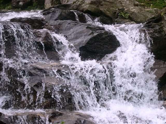
76 Himalayan Mountaineering Institute Rock Garden


77 Trying out stunts at Tenzing Rock Peace Pagoda

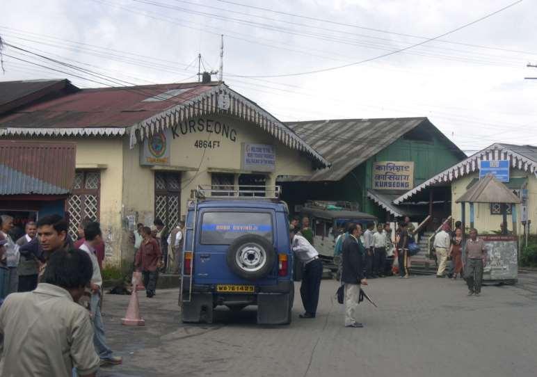
78 Darjeeling Ropeway Kurseong Station

79 Sunrise over tiger hill Land Rover on way to Sandakphu


80 Tongsa Gompa, Kalimpong Beautiful Mirik Lake

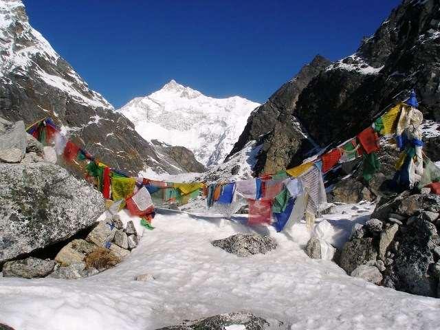
81 ADVENTURE IN SIKKIM

82 While at Sikkim, you can enjoy river rafting at Rangit and Teesta. These two rivers provide right environment for white river rafting and is safer as well. You can choose from 15 minute rafting to that of 50 minutes and would be a thrilling experience. Teesta has chilling waters but with normal rapids where as Rangit is fierce and and turbulent thus categorized as challenging rafting. Yuksom-Dzongri Trek The awesome presence of the great mountains thrusting their snowy peaks is always a fascination to most of us. No less than 14 of them soar majestically to 20,000 ft. plus. The centre of attraction of course remain the Kanchendzonga, the 3 rd highest mountain in the world. In this 6 night and 7 days trek you could enjoy following: 1. Last inhabited village at Tshoka. Tshoka means hutment 2. Kanchendzonga massif along with Mt.Pandim and Mt.Kabru at striking distance. 3. Dzongri top or Dabla Khang at 13,220 feet you would feel like world at your footsteps after getting that experience. 4. Rhododendrons and Magnolia trees with their flowers blooming making the air filled with amazing fragrance. 5. From Dzongri you can climb upwards closer to Mt.Pandim to reach Bikbari and further down to HMI camp and from that point you can enjoy the views of Kanchendzonga ranges 6. Experience stay in huts / tents which has its own uniqueness. 7. Continue onto Goecha La via Thangsing which is covered in next section. Trekking in Sikkim region Yuksom-Goecha La Continuing further on from Dzongri and onto Thangsing which is 7 kms from Dzongri you will reach this fascinating place where camping can be done. From Thangsing, Mt.Pandim offers a brilliant sight. Here are the highlights of this trek: 1. Get mesmerized at Samiti Lake beyond Thangsing. A camp at this lake provides a nostalgic experience. 2. Goecha La is 5 kms from Samiti Lake but takes 4-5 hours to reach. There are 3 view points and you can see each of them bringing you nearer to Kanchendzonga 3. Goecha La is also called as Kanchendezonga base camp trek 4. You will be seeing a vast panaroma unfolding before you towards South of Kanchendzonga 5. Goecha La is at 16,210 feet Best time to visit: May Nov Highest point : Dzongri and Goecha La Grade: Strenuous Sandakphu-Phalut Trek This 8 nighs and 9 days trek takes you to amazing regions of Darjeeling district and stay in Nepal for few days with awesome views of Kanchendzonga and other related moutain ranges. This is the only trek which can be done by a 7 year old as well as 60 year old with ease. Highlights of this trek are: 1. See Kanchendzonga and Mt.Everest and Makalu at Sandakphu and Phalut 2. Stay in India and Nepal by stepping on a mile marker 3. See the divine lake of Kalphokri which bring in dreams come true Best time to visit: Across the year except for June-Aug Highest point : Sandakphu - 12,400 ft and Phalut 11,800 ft Grade: Easy / Moderate
83 Sikkim and Darjeeling Best time to visit Darjeeling and Sikkim since the terrain is very vast; you will find variations in temperature. The suggested period are: April to Nov Perfect holiday experience Dec to March : Winter experience with snow North Sikkim May to November. Climate condition Sikkim has all kind of seasons and generally cloudy during months of June-Sept. Snow from Dec-March in most of high areas and clear sky in Gangtok, Yuksom and Pelling etc., Temperature Entire Sikkim and Darjeeling Pleasant Moderate May ~ Sept April and Oct Very cold. Freezing : Nov ~ March Mobile phones Postpaid Private and BSNL works in towns like Gangtok, Pelling and Yuksom. Better to have BSNL mobile apart from private operator. For detailed itineraries, please visit: All our tours are customizable and hence the itineraries are just suggestive. Do call us for customizing as per your needs.


84 BHUTAN Referred as the Last Shangri La is a landlocked country covering an area of 39,000 sq.km. Its boundaries to East, West and South lie Arunachal Pradesh, Sikkim and West Bengal and Assam while North is connected with Chumbi Valley of Tibet The most interpretation is that it is derived from Bhot-stan, or land of Bhotias In Sanskrit, Bhotias referred to Easterners British explorers to this country called as Bootan or Bhotan and now called as Bhutan. Bhutanese refer to this country as Druk-Yul or Land of Thunder dragon. Welcome to this country where people are self disciplined and require no traffic lights for cars.
85 BRIEF HISTORY Bhutan, the land of Thunder Dragon is often linked with religious figures and events relating to them. As per the known records, the history can be traced to 7 th century AD where Tibetan king Songsten Gampo constructed its first two Buddhist temples Kyichu in Paro valley and Jambay in the Choekhor valley in Bumthang. Before advent of Buddhism like in other Himalayan kingdoms, Bon religion was prevalent. During 746 AD, Indian king of Bumthang, Sindhu Gyab or Sindhu Raja was at war with the rival king and lost his son in battle. In his distraught state he angered the region s chief deity who extracted his vital force almost killing the king. At that time, Guru Padmasambhava the tantric master from India was invited. Using his supernatural powers, he succeeded in subduing the wrathful deity and converted the king, the rival king and this wrathful deity to Buddhism thus making the kingdom free from violence. Guru Padmasmbhava during meditation left an imprint (jey) of his body (kur) on a rock that can be viewed at Kurjey Lhakhang even today when you visit Bhutan. He visited many parts of Tibet and Bhutan performing one miracles after other and subduing negative forces and converting them to Buddhism and liberating them of wrathful nature.he is known across Himalayan kingdom as Guru Rinpoche and has been meditating in various caves of Indian, Tibetan and Bhutanese caves. Guru Padmasambhava (Born out of Lotus) visited Tibet at the invitation of Trisong Detsen and helped the king to build Samye Gompa. After its completion, a monk body was installed and a new school of Buddhism was introduced which let to the ascendancy of this religion in Tibet. He then returned to eastern Bhutan and at the Gom Kora is a rock that bears an imprint of his body, head and hat. The most notable of Guru Padmasambhava is of construction of Tiger Nest monastery which stands at Paro. It is said that he flew on the flaming tigress thereby giving the name of Tiger Nest. This monastery is named as Taksang Gompa. When you visit Taksang Gompa, if you are a blessed soul, you would be able to see the cave he meditated in the cliff side. Lama Tsangpa Gyarey Yeshe Dorje ( ) was building a monastery in the town of Ralung, East of the famous gompa at Gyantse. During the consecration, there was a loud thundering sound which was popularly believed to be the voice of the dragon (Druk), expounding the great truths of Buddhism and was called Drukpa Kagyu. During 17 th century when Bhutan was united under this form of Buddhism, they gave the country the name of Druk Yul or Land of Thunder Dragon, and the inhabitants were called the Drukpas. The language which was closely related to Tibetan was called as Dzongkha. Bhutan was more often than not was ruled by chieftains vying with each other for supremacy or greater powers from time to time. Since there used to be consistent wars either within or with Tibet, the stage was set for one of the Bhutan s most charismatic and influential leaders Zhabdung Rinpoche (Ngawang Namgyal ). He was a descendant of Tsangpa Gyarey, the founder of the Drukpa lineage at Ralung. He was extremely powerful from his young age and was recognized as the reincarnation of Pema Karpo, the prince abbot of the monastery. He travelled extensively in West Bhutan, teaching the Kagyu precepts while growing in political stature. Repelling Tibetan invasions, he established the dominance of the Drukpa Kagyu sect and took the tile of Zhabdung at whose feet one submits and sought to unify the region under the banner of Druk Yul and hence considered as founder of Bhutanese state. He was instrumental in building Dzongs in every part of country to have exercise of the powers in a better way both from administration and defense. The mighty dzong at Simtokha near Thimphu was his first symbol of authority. This eclectic combination of civil, military and religious authority became the model for all future dzongs in the country and can be seen till today. During 1800 to 1900, British negotiated the river sharing popularly known as duars and there is huge history behind it and would be pages after pages of Bhutanese history. To cut it short, with treaty of Sinchula, Bhutan agreed to give complete control of duars thus allowing free trade. Bhutan reformed in various areas and was under isolation for more than a century. Right now, Bhutan is regarded as most happiness country as it measures prosperity by the happiness than the monetary gain. Also, this country does not require discipline since people are highly disciplined and most of them extreme honest. Television came into Bhutan in 2005 and internet was given permission in 2008 thus removing isolation from rest of the world. Now, Bhutan has hotels ranging from ordinary to 5 star and the roads have been built up along with power generation which is loaned to India. Bhutan any day will fascinate anyone visiting this marvelous country and should not be missed by any human being in his lifetime.

86 With office in Bhutan, we assist fellow travelers be it just a back-packer or a family on holiday or adventure enthusiast with all logistical arrangements from planning stage to completion of tour or adventure. Our itenerary is fully customizable to suit the needs of travelers interest, budget and time on hand. We provide off-beat, standard and all woman tours to this exotic land of Bhutan where you feel like coming back again and again. Tashi Delek!! Phuentsholing This is the place which you would reach once you start from Siliguri crossing over Coronation bridge and passing by last town/village at Jaigon. Resting here for the night and next day morning, is the time to have permits done. Refer to permit section in this document. Places around Phuentsholing are: 1. Zangtho Pelri Lhakhang Situated in city centre, this small temple represents the heaven of Guru Rinpoche. Zhangtho Pelri at Phuentsholing Bhutan. On ground floor there are statues of eight manifestations of Guru Rinpoche and paintings on Buddha's life while the next floor contains eight Bodhisattavas and statues of Avalokiteshvara and Shabdrung Ngawang Namgyal. On top floor, there is a main statue of Amitabha. 2. Kharbandi Goemba Founded in 1967 by Royal Grand Mother, Ashi Phuntsho Choedron and situated at the altitude of 400m, this beautiful monastery contains paintings on the life of Buddha, statues of Shabdrung Ngawang Namgyal and Guru Rinpoche. From the monastery garden there is a fascinating view of Phuentsholing town and surrounding plains. Haa Valley Permission was granted to visit Haa Valley for the very first time in 2002 for tourist as this lies in the sensitive area closer to China. Haa Valley..(cont) This picturesque place is so mcuh fascinating that one does not feel like returning back. Before advent of Buddhism here, people used to follow animist culture and due to Guru Padmasambhava s grace (Guru Rinpoche) this place was transformed to be highly peaceful and spiritual. It is culturally rich valley and some of famous sites in this region are : 7th century Lhakhang Karpo (White temple) and Lhakhang Nagpo (Black temple) at the foothills of a venerated three brotherly mountains known as Meri Puensum. The grand annual Haa Tshechu is also performed here at Lhakhang Karpo on the 8th-10th day of the 8th Bhutanese month. The Haa Wangchuklo Dzong built in 1915 after the Dumchog Dzong was razed to the ground by fire is worth visiting. The other place of interest which involves some walking includes the hike to the 8th century Juneydrag, Katsho Goempa, Drana Trashidingkhag, Yangto Goempa, Jamtoe Goempa, Shelkardrag, Takchu Goempa and Haa Goempa. The valley is also unparalleled in Bhutan in terms of the diversity of the folk culture, legends and shamanistic rituals similar to one done in Sikkim. The drive to Haa valley crosses 3988m Chele-la pass, from where one can have a superb views of Mount. Chomolhari & Jichu Drakey. It is also an ideal place to take short walk, enjoying panoramic vistas. Gangtey (Phobjikha) valley The valley of Gangtey is one of the most beautiful spots in Bhutan. The surprise of finding such a wide, flat valley without any trees after the hard climb through dense forests is augmented by an impression of vast space, and extremely rare experience in Bhutan where most of the valley s are tightly enclosed. A few kilometers beyond the Gangtey Monastery, on the valley floor lies the village of Phobjikha. This place is the winter home of black necked cranes that migrate from the arid plains in the north to pass winter in milder and lower climate. Phobjikha, at an altitude of 2900 m, falls under the district of Wangduephodrang and lies on the periphery of the Black Mountain National Park. The valley boasts two beautiful meandering rivers, Nakay Chhu (Chhu Naap-black water) and Gay Chhu (Chhu Karp-white water). Places of interest near Phobjikha Gangtey Goempa Perched on a small hill that rises from the valley floor, the Gangtey Monastery is the only Nyingmapa monastery on the western side of the Black Mountain sgangtey valley, Bhutan and also the biggest Nyingmapa monastery in Bhutan. The Monastery is surrounded by a large village inhabited mainly by the families of the 140 Gomchens who take care of the Monastery.
87 Phobjikha..(cont) Black Necked Crane Information Centre Situated on the edge of the forest and wetland along the main road of Phobjikha valley, the black-necked crane information Centre has an observation room equipped with high power telescope and spotting scopes for catching the best view of the cranes. The centre also offers display information that outline the natural and cultural history of the area. There is a small gift shop, which sells handicrafts produced by the local people. Trashigang Situated at altitude of 1100m/3610ft on the bank of Gamri Chhu river lies Trashigang, the country's largest district. Trashigang, once the centre of a busy trade route with Tibet, is today the junction of east-west highway with road connecting to Samdrup Jongkhar and then to the Indian States of Assam. This town is also used as the market place for the semi nomadic people from Merak and Sakteng whose costumes are unique in Bhutan. Around Trashigang Trashigang Dzong Built in 1659, the Dzong serves as the administrative seat for the district as well as the home of the monk body. The Dzong commands a remarkable view over the surrounding countryside. Gom Kora 24 km from Trashigang, the temple of Gom Kora is set on a small alluvial plateau overlooking the river. Surrounded by rice fields and clumps of banana tress, it looks like an oasis in an arid landscape. It is one of the famous places where Guru Rinpoche meditated in order to subdue a demon who dwelt in a huge black rock. Trashiyangtse Situated at an altitude of5580ft, is a rapidly growing town and administrative center of the district. A small river valley, it is a lovely spot from which to take walks in the surrounding countryside. Around Trashiyangtse Chorten Kora This dazzling white stupa is situated on the riverbank below the town. Constructed in 1740 by Lama Ngawang Loday, it is built in the same style as Bodhnath stupa in Nepal, with eyes painted at the four cardinal points. During the second month of the lunar calendar there is an interesting celebration here, known as 'Kora'. Bomdeling A pleasant walk of about three hours from Chorten Kora, Bomdeling is an annual migration place for blacknecked cranes, which fly over from nearby Tibet to pass the winter months in a warmer climate. Trashiyangtse Dzong Trashiyangtse Dzong meaning Fortress of Auspicious Fortune, was re-built in 1656 by Terton Pema Lingpa from the ruins of Dongdi Dzong of 9th century. It was further renovated and sanctified by a sacred consecration ceremony in Around Trashiyangtse Bomdelling A pleasant walk of about three hours from Chorten Kora, Bomdeling is an annual migration place for blacknecked craens, which fly over from nearby Tibet to pass the winter months in a warmer climate. Ranjung Woesel Chholing This monastery is more than half an hour drive from Trashigang town. It is a Nyingmapa monastery founded by Garab Rinpoche in One can get a good view of the valley from the monastery. Mongar The journey from Bumthang to Mongar is one of the most beautiful in the Himalayas crossing 4,000m high Thrumshing la (pass). Gushing waterfalls, steep cliffs with even steeper drops, blazing flowers and constantly changing vegetation combine to make this journey as varied as it is beautiful. Mongar marks the beginning of Eastern Bhutan. The second largest town in the sub-tropical east, Mongar like Trashigang further east, is situated on the side of a hill in the contrasts to other towns of Western Bhutan which was built on the valley floor. Mongar Dzong It is site of one of Bhutan's newest Dzong built in 1930s. Yet the Dzong is built in the same method and traditions of all the other Dzongs; no drawings and nails have been used. A visit gives visitors an impression of how traditional Bhutanese architecture has continued to thrive through the centuries. Yakang Lhakhang Located at about 20 minutes walk from Mongar town, this privately owned monastery was founded by Lama Sangdag, the sixth son of Terton Pema Lingpa. It is of great cultural significance and a repository of a wide range of spiritual treasures and other sacred objects known to have been revealed by Terton Pema Lingpa. Drametse Lhakhang Dramtse Lhakhang means, the peak without enemy, is one of the largest and most important monastery in eastern Bhutan, situated about 18 km away from Trashigang to Monger highway. The lhakhang was founded by a highly accomplished Ani (nun) named Choten Zangmo in the 16th century, the granddaughter of the famous religious master Terton Pema Lingpa (the Treasure Discoverer). The lhakhang is deeply associated with Terton Pema Lingpa and the Peling tradition of Buddhism. It houses a full range of spiritual treasures and other sacred objects and is the source of spiritual inspiration to the people of Drametse and neighbouring communities.
88 Lhuntse Lhuntse is 77 km from Mongar (3 hours drive) and is one of the most isolated districts in the country. The landscape here is spectacular with stark cliffs and gorges and dense coniferous forests. The region is notably famed for its weavers and their special textiles generally considered to be the best in the country. The Kurtoe region of Lhuntse is also the ancestral home of royal dynasty. Bumthang or Jakar valley Bumthang situated at an altitude of 8530ft-14765ft has an individuality that charms its visitors and separates it from other regions. Comprising of four smaller valleys namely Tang, Ura, Choekhor and Chumey, the deeply spiritual region of Bumthang is shrouded in religious legend. Bumthang is also the traditional home to the great Buddhist teacher Pema Linga to whose descendants the present dynasty traces its origin. Around Bumthang or Jakar 1. Jambay Lhakhang This monastery was built in the 7th century by Tibetan King, Songtsen Gampo. It is one of the 108 monasteries built by him to subdue evil spirits n the Himalayan region. 2. Kurje Lhakhang Situated before Jambay Lhakhang, Kurje Lhakhang consists of three temples. First temple was built in 1652 on the rock face where Guru meditated in the 8th century. Second temple is built on the site of a cave containing a rock with the imprint of Guru's body and is therefore considered the most holy. The third temple was built in 1990s by Ashi Kesang, the Queen Mother. These three temples are surrounded by a 108 chorten wall. 3. Tamshing Lhakhang Located across the river from Kurje Lhakhang, this temple was founded in 1501 by Terton Pema Lingpa, the re-incarnation of Guru Padsambhava. 4. Tamshing Lhakhang..cont The monastery has very ancient religious paintings like 1,000 Buddhas and 21 Taras (female form of Buddhistava). The temple was restored at the end of the 19th century. 5. Jakar Dzong Founded by great grand-father of the first Shabdrung, the Dzong was initially built as a monastery in It was upgraded after the Shabdrung had firmly established his power in The Dzong is now used as administrative centre for Bumthang valley, and houses the regional monk body. 6. Konchogsum Lhakhang It was built in the 6th century and renovated in 1995, which accounts for its fresh look. It contained a large bell and it is said that when this bell was rung it could be heard all the way in Lhasa in Tibet. During the 17th century a Tibetan Army tried to steal this bell but was too heavy and they dropped it and cracked it. It is now displayed at the National Museum in Paro. 7. Chankhar Lhakhang Beyond Jambay Lhakhang is Changkhar Lhakhang, the site of the palace of the Indian King Sindhu Raja. Because of its simplicity it looks like an ordinary village house. The original palace was built of iron and this is why it was named Chankhar, meaning iron castle. It was rebuilt in the 14th century by a Saint called- Dorji Lingpa. 8. Lhodrak Kharchhu Monastery: Located above the main town, about 3 km from Chamkhar town, the monastery was founded by Namkhai Nyingpo Rinpoche in 1984 who was recognized at a very young age by H.H. the 14th Dalai Lama and H.H. 16th Karmapa as the reincarnation of a Tibetan lama whose spiritual lineage dates back to the nearest disciples of the great 9th century master. Since then the monastery has developed considerably with increase in number of monks to almost four hundred. The monastey has become part of an extensive effort to preserve and revitalize Tibetan culture. 9. Tangbi Goemba A walk of half an hour north of Kurje Lhahang leads to this monastery, founded in 1470 by Shamar Rinpoche of the Kagyupa religious school. The temple has two sanctuaries and a temple of terrifying deities. The sanctuary on the ground floor contains statues of past, present and future Buddha and three clay statues probably dating end of the 15th century. On the upper floor, the vestibule contains two remarkable paintings of Guru Rinpoche's heaven and the Buddha Amitabh's heaven. 10. Ngang Lhakhang A few hours walk from the Tangbi Goemba is the small region of Ngang Yul (Swan Land) and this temple here is 100 m above the valley floor. The site was visited by Guru Rinpoche and present temple was built in the 15th century by Lama Namkha Samdup, a contemporary of Pema Lingpa. A three days festival is held here each winter with masked dances in honor of the founder of the temple. 11. Ura Valley Jakar to Ura is 48 km, about one and a half hour drive. To reach here, the road climbs tojakar valley Bhutan amazingly open countryside, only occasionally running into forest. Large sheep pastures line the road up to 20 km behind the southern tip of the Tang valley. The route crosses Ura la pass (3,600m) with a magnificent view of Mount. Gangkhar Puensum. Villages in Ura have clustered houses, which is quite unusual in Bhutan. Above Ura village (3,100m) is a new temple dedicated to Guru Rinpoche. Inaugurated in 1986, it contains a huge statue of the master and remarkable paintings of the cycle of his teachings. Since last 25 years Ura has been transformed from a marginal community to prosperous valley.
89 12. Membartsho (The Burning Lake) in Tang valley is a wide spot on the Tang Chhu (chhu - water / river) and is considered to be one of the greatest pilgrimage sites of Bhutan. Pema Linga found several of Guru Rinpoche's hidden treasures here. The importance of this site is indicated by the extensive array of prayer flags and the small clay offerings called 'Tse Tsa' in rock niches. 13. Ugyenchholing Palace In Tang valley is another attraction. Restored in 19th century, it is now housing the Family Museum, a place that will transport visitors to another world and time. The visitors will view permanent exhibits recreated to capture the ambience of the lifestyle of the Trongsa Penelop (Governor) Tshokey Dorji and his household. It also serves as retreat for those engaged in religious history. Bhutan's history truly unfolds here. 14. Tang Rimochen Lhakhang In the valley is a sacred place of Guru Rimpoche. A rock in front of temple bears a body print of the Guru and two khandroms (female celestial being). The site is named after the tiger stripe markings on the cliff. Footprints of the Guru and his consorts Mandarava and Yeshe Chhogyal are found below the lhakhang. Two large boulders nearby are said to be male and female jachungs (garudas). 15. Kunzangdrak Goemba Two hours walk above Chel Tang Valley. It is one of the most important sites related to Pemalingpa the great treasure discoverer in Bhutan, who also constructed the Goemba in Most of his sacred relics are kept here including the gilded stone bearing his footprint. 16. Pelseling Goempa A sacred monastery with rich historic values is situated on a steep mountain, it is a half day trek (3-4 hours) from the area of Jakar. The trek starts off at a mild pace but later gains momentum. Along the trek route, travelers are gifted with breathtaking views of the valley and large species of flora and fauna. 17. Pelseling Goempa..cont About two thirds of the way, there is a beautiful meadow which is the perfect picnic spot. The last part of the hike requires more uphill trek until eventually the destination makes you feel blissed. Wangduephodrang Wangduephodrang situated at an alt. 1300m./4265ft is the last town on the central highway before central Bhutan. The town is not more than an enlarged village with a few wellprovided shops. Located in the south of Punakha, the higher reaches of the Wangduephodrang valley provide rich pastureland for cattle. This district is also famous for its fine bamboo products, slate and stone carvings. Punakha Punakha situated at an altitude of. 1300m/4265ft served as the capital of Bhutan and still it is the winter seat of Je Khenpo (the chief abbot). Blessed with temperate climate and owing to its natural drainage from Pho Chhu (male) and Mo Chhu (female) rivers, the Punakha valley produces abundant crops and fruits. There are splendid views of the distant Himalayas at Dochula pass (alt. 3,050m) on Thimphu Punakha road. Around Punakha 1. Dochu La Dochula pass is located on the way to Punakha from Thimphu. The pass is a popular location among tourists as it offers a stunning 360 degree panoramic view of Himalayan mountain range. The view is especially scenic on clear, winter days with snowcapped mountains forming a majestic backdrop to the tranquility of the 108 chortens gracing the mountain pass. Known as the Druk Wangyal Chortens- the construction of these108 chortens was commissioned by the eldest Queen Mother, Her Majesty Ashi Dorji Wangmo Wangchuk.. Dochu La.cont The pass is also popular spiritual destination for both locals and tourists because an important temple is located on the crest of Dochula pass. The Druk Wangyal Lhakhang (temple) was built in honor of His Majesty the fourth Druk Gyalpo, Jigme Singye Wangchuck. The past and future appears to merge in the details of the lhakhang (temple) and its structure tells the story of a supreme warrior figure, whose vision pierces the distant future in a fine blend of history and mythology. 2. Punakha Dzong Built strategically atthimphu town the junction of Pho Chhu and Mo Chhu rivers in 1637, by Shabdrung Ngawang Namgyal to serve as the religious and administrative centre of the region, Punakha Dzong has played an important role in Bhutan's history. Damaged by four catastrophic fires and an earthquake, the Dzong has been fully restored by the present King. The Dzong is open for visitors during Punakha festival and in summer months when the monk body moves to Thimphu. 3. Chimi Lhakhang The Chimi Lhakhang, situated on a hillock in the centre of the valley, is dedicated to Lama Drukpa Kuenley, who in the late 15th century used humour, songs and outrageous behavior to dramatise his teachings and due to this also known as "Divine Madman". This temple is also known as the temple of fertility. It is widely believed that couples who do not have children and wanting one, if they pray at this temple, they are usually blessed with a child very soon. It is about 30 minute walk across field from the road to the temple. The trail leads across rice fields to the tiny settlement of Pana, meaning "field". It then follows a tiny stream downhill to Yoaka and across more fields before making a short climb to Chimi Lhakhang.
90 4. Khamsum Yulley Namgyal Chorten A beautiful hike takes one to the regal Khamsum Yuelley Namgel Chorten, which was built to remove negative forces and promote peace, stability and harmony in the changing world. The Chorten dominates the upper Punakha Valley with commanding views across the Mo Chhu and up towards the mountainous peaks of Gasa and beyond. 5. Sangchhen Dorji Lhuendrup Lhakhang Nunnery Perched on a ridge amid pine trees and overlooking valleys of Punakha and Wangduephodrang, gleams the magnificent structures of Sangchhen Dorji Lhuendrup Lhakhang(Temple). The temple houses a 14-foot main bronze statue of Avalokiteshvara (Chenrigzig chagtong chentong). Other statues include those of Guru Padmasambawa, Gautama Buddha, Zhabdrung Ngawang Namgyel, Tsela Namsum, the 21 Taras and Tsepamay (Buddha of longevity). The Avalokiteshvara statue, one of the biggest in the country, was the handiwork of entirely local Bhutanese artisans. The temple complex also houses a permanent higher learning and meditation centre for nuns where, apart from religious trainings, it provides life skill training such as tailoring, embroidery, statue making and thangka painting. 6. Limbukha Drive towards Punakha Dzong and later walk across the suspension bridge (about 200m long) through absolutely fresh breeze and fascinating view of Dzong. Follow the farm houses gradually climbing towards Dompala hills. The view of Dzong, Pho Chhu, Mo Chhu rivers and surrounding village is superb amidst chirpine forests. The climb is another two and a half hours to Limbukha. Limbukha farmers grow Bhutan's famous red rice which is supposed to have medicinal values. This particular rice needs clean mountain spring so that the taste is good and nutritional value maintained. Limbukha is also known for its love of peace and tranquility. Legends says that during medieval wars the "limpus" or the people of Limbukha always volunteered as peace negotiators. This is also depicted during yearly festival called 'Serda' when the men are found carrying peace flags instead of swords and fireworks. 7. Talo The village of Talo (alt. 2,800m) which is scattered along the hill slopes, known for its cleanliness and hygiene among Punakha villages. Talo Sangnacholing is built on a plateau and has majestic view of surrounding villages. The beautiful farm houses of the village have its own flower gardens and on the hill slope corns and sweet peas are grown in abundance. The women of Talo are particular known for their beauty. 8. Punakha Ritsha Village Bhutan s Punakha valley is famous for rice farming where both red and white rice are grown along the river valleys of Pho and Mo Chhu, two of the most prominent rivers in Bhutan. Ritsha meaning at the base of a hill is a typical village in Punakha. The village houses are made of pounded mud with stone foundations. Each house is only two storey high surrounded with gardens and the rice fields. The gardens also usually have fruit bearing plants like oranges and papaya among the organic vegetables. In the recent years, the farming work is mechanized and power-tillers instead of bullocks are used to plough the fields and villagers have become relatively prosperous. This is a model rice growing village in western Bhutan. 9. Nalanda Buddhist College Locals call this place Dalayna while the monks refer it as Nalanda Buddhist College. Drive here in the afternoon and enjoy your evening tea supplemented by the ravishing view in front, along with interaction with local monks. Thimphu The capital town of Bhutan situated at altitude of 2400m/7875ft is the centre of government, religion and commerce, Thimphu is a unique city with unusual mixture of modern development alongside ancient traditions. Although not what one expects from a capital city, Thimphu is still a fitting and lively place. Home to civil servants, expatriates and monk body, Thimphu maintains a strong national character in its architectural style. Around Thimphu 1. Memorial Chorten This stupa was built in 1974 in the memory of Bhutan's third King, His Late Majesty, King Jigme Dorji Wangchuk, who is popularly regarded as Father of modern Bhutan. Thimphu townthe paintings and statues inside the monument provide a deep insight into Buddhist philosophy. 2. Simtokha Dzong This dzong, built in 1627 by Shabdrung Ngawang Namgyal, stands on a low ridge 8 km down the valley from Thimphu. The Institute for Language and Cultural Studies is located here. The most noteworthy artistic feature of this dzong is the series of over 300 finely worked slate carvings behind the prayer wheels in the courtyard. 3. National Library The history of Bhutan lies imprinted in archaic texts, which are preserved at the National Library. Besides thousands of manuscripts and ancient texts, the library also has modern academic books and printing blocks for prayer flags. 4. Institute for Zorig Chusum Commonly known as Arts & Crafts School or Painting School, the Institute offers a six-year course on the 13 traditional arts and crafts of Bhutan. On a visit, one can see students learning the various skills taught at the school.
91 5. Traditional Medicine Institute In Bhutan, equal emphasis is given to both allopathic and traditional medicines. The rich herbal medicines made up from medicinal plants abundant in the Kingdom are prepared and dispensed here. The Institute is also a training school for traditional medicine practitioners. The complex is closed to visitors due to considerations of hygiene, but one can still walk around and view it from outside. 6. The Folk Heritage Museum (Phelchey Toenkhyim) It is dedicated to connect people to the Bhutanese rural past through exhibits, demonstrations, educational programmes and documentation of rural life. The principal exhibit in the museum is a restored three storey traditional rammed mud and timber house, which dates back to the mid 19th century. The design and form of house is that of an average household in the Wang area during that era. The age of structure demonstrates the durability and performance of the building materials. From ground to top floor, household objects, typical domestic tools and equipments that would have been used by a family during that period are put on display. The museum is also developing some of the native trees and plants that were used for various domestic purposes in the rural households. 7. National Textile Museum With the opening of Textile Museum, under the patronage of Her Majesty the Queen Ashi Sangay Choden, Bhutanese textile have reached new heights as one of the most visible distinct art form. The textile museum has opened its exhibition on six major themes - warp pattern weaves, weft pattern weaves, role of textiles in religion, achievements in textile arts, textiles from indigenous fibers and the royal collection. The crowns of Bhutan's Kings, namzas (dresses), the first version of Royal Crown and other accessories used by members of Royal family can be found in the museum. The goal of the museum is to gradually become a center for textile studies that will carry out documentation, research and studies on Bhutanese textiles. 8. Trashichhoedzong Also know as "fortress of the glorious religion", Trachicho Dzong Thimphuit was initially built in 1641 and later rebuilt in its present form by King Jigme Dorji Wangchuk in The Dzong houses, main secretariat building which houses the throne room of His Majesty, the King of Bhutan. The National Assembly Hall is housed in a modern building on the other side of the river from the Dzong. During the warmer summer months, the monk body headed by His Holiness, the Je Khenpo, makes its home in the Dzong. 9. Handicrafts Shops A wide assortment of colorful, hand woven textiles and other craft products is available for purchase at the government-run Handicrafts Emporium and many smaller crafts shops around the town. 10. Weekend Market Every Saturday and Sunday most of Thimphu's scant population and many valley dwellers congregate on the banks of the river where weekend market is held. It is an interesting place to visit and provides opportunity to mingle with the local people. 11. Changangkha Lhakhang It is a fortress like temple and monastic school perched on a ridge above Thimphu, south of Motithang. The temple was established in 12th century on a site chosen by Lama Phajo Drugom Shigpo, who came from Tibet. The central statue here is Chenrezig in a manifestation with 11 heads. From temple courtyard, there is fascinating view of Thimphu valley. 12. Craft Bazaar Organised on Tuesday and Wednesday in Centenary Farmer s market, under patronage of Department of cottage & small industry and in collaboration with the department of culture, tourism council and the department of agriculture marketing and cooperatives, this market offers genuine Bhutanese arts & crafts thus contributing in promotion, protection and preservation of traditional arts. 13. Junghi Handmade Paper Factory Junghi Paper factory comprises of two enterprises ; the unit in Thimphu produces traditional handmade paper from natural plants mainly from Daphne plant species which is insect-resistant. The other unit in Jimina, 22 km from the centre Thimphu town, recycles waster papers. The traditional handmade papers are widely used for religious scripts, packing materials, hand-carry bags, lampshades, envelopes, calendars. The paper looks a lot like Japanese washi, and in fact a lot of Bhutanese paper is exported to Japan also. 14. Zangthopelri Lhakhang The present structure was built in 1960s and although lacking the charm of many of the older temples, Zangthoo pelri still possesses some impressive murals and art treasures and is worthy of a visit. The site of the temple was a former battle ground, and the temple was constructed there in order to pacify energies. 15. Buddha Point (Kuensel Phodrang) Located at a short drive from Thimphu city centre, visitors can get a good overview of the Thimphu valley from the Buddha point (Kuensel Phodrang). You can pay your obeisance and offer prayers to the Buddha, the largest statue in the country and then walk around and take a glimpse of the valley. 16. Simply Bhutan Museum Simply Bhutan is an exclusive project under the simply bhutan museumbhutan Youth Development Fund (YDF), built to offer a unique experience to its visitors. It is a living museum and studio encapsulating the cultural heritage of the Bhutanese people. A distinctive feature of Simply Bhutan is that it fully operated by young people and job seekers, who receive here on the job training in basic business & management skills, customer care and other spheres of life.
92 17. Simply Bhutan Museum..cont The fund generated through Simply Bhutan is utilized to run many of the youth development programmes for vulnerable and disadvantaged youth under YDF. Hence as a visitor, while you get to experience and enjoy this special place, you are also helping to make a better today, a brighter tomorrow, for the youth of Bhutan. 18. Drubthob Goema / Zilukha Nunnery Perched on a promontory, overlooking picturesque Trashichhoedzong and Golf course, it is the only nunnery in capital known as Zilukha Anim Dratsang. Once belonged to the Drubthob (Realized one) Thang Thong Gyalpo often referred to as The King of the open field (In the early 15th century with his multiple talents he popularly became the Leonardo da Vinci of the Great Himalayas). You may interact here with some of the nuns who have devoted their life to spirituality and Buddhism. Around Thimphu Valley 1. Tango Goemba This monastery was founded by Lama Gyalwa Lhanangpa in the 12th century and the present building was built in the 15th century by the "Divine Madman", Lama Drukpa Kunley. In 1616 Shabdrung Ngawang Namgyal visited Tango and meditated in a cave near the monastery. His meditation helped ensure the defeat of an invading Tibetan army. The head Lama, a descendent of Lama Drukpa Kunley presented the goemba to Shabdrung, who carved a sandalwood statue of Chenrezig which he installed in the monastery. The picturesque three-storey tower and several surrounding buildings were built in the 18th century by the eighth Desi, Druk Rabgye and Shabdrung Jigme Chhogyel added the golden roof in the 19th century. Situated north of Thimphu, one way it takes about 30 minutes drive and one hour walk through shaded rhododendron forests to reach the monastery. 2. Cheri Goemba This monastery was built by Shabdrung Ngawang Namgyal in A silver chorten inside the monastery holds the ashes of Shabdrung's father. The goemba is situated about half an hour walk from Dodena (alt. 2,600m). The trail commences by crossing a traditional wooden bridge that spans the Thimphu Chhu, then climbs steeply to the monastery. Being the place where the Shabdrung spent many years in meditation, Cheri today has numerous hermitages and small temples located on its slopes, commanding spectacular views. The one way walk to the monastery is approx 4.5 km, taking about 2 hours. 3. Phajoding Goemba It is a 5 km uphill walk from Motithang. The monastery was built in 15th century by Shagcha Rinchen who introduced the Drukpa Kagyupa school in Bhutan in the 13th century. It was one time one of the richest monasteries in the country. 4. Lungchuzekha Goemba It is an interesting three to four hours round trip walk around Dochula pass, offering fascinating view of Bhutan Himalayas. From 108 chortens and mani wall at Dochula pass, the road ascends gradually into white, red and pink rhododendron forests for about one and a half hour with some steep sections before branching left to Lungchuzekha Goemba. The highlight of this excursion is beautiful forest, spectacular mountain views and monastery. 5. Takin Preserve, Motithang The Takin is the national animal of Bhutan, and looks like a cross between a cow and a goat. Legend has it that the animal was created by the great Buddhist yogi, Drupa Kunley, and it can be found only in Bhutan and nearby areas. Taxonomists place the animal in a category of its own as it is not similar enough to any other animal to fit established categories. 6. Coronation Park Located on the banks of the river (near the city stadium), this 5.6 acres of parkland offer a pleasant and relaxing environment to stroll or to sit and watch the river flow by. 7. Botanical Gardens, Serbithang Located on lush hillside about 10km from the city, the gardens offer a peaceful and relaxing environment to spend a few hours. Botanists will find the wide selection of indigenous trees and plants of interest. 8. Tandin Nye This sacred lhakhang is about 1 km from the main town, built on a cliff, just like the Tiger s Nest in Paro. The visit to the temples provides an opportunity to feel and see the great work of ancient Buddhist legends. It is believed that there use to a lake below the lhakhang but now one can found only a marshy area. Paro The beautiful valley of Paro situated at an altitude of 2200m/7218ft encapsulates within itself a rich culture, scenic beauty and hundreds of myths and legends. It is home to many of Bhutan's oldest temples and monasteries, National Museum and country's only airport. Taksang Monastery overlooking Paro valley is striking from every corners. Mount. Chomolhari (7,314m) reigns in white glory at the northern end of the valley and its glacial water plunge through deep gorges to form Pa Chhu (Paro river). Paro is also one of the most fertile valley in the Kingdom producing a bulk of the locally famous red rice from its terraced fields. Around Paro 1. Rinpung Dzong Built in 1646 by Shabdrung Ngawang Namgyal, the first National Museum Parospiritual and temporal ruler of Bhutan, the Dzong houses the monastic body of Paro, the office of the Dzongda (district administrative head) and Thrimpon (judge) of Paro district. The approach to the Dzong is through a traditional covered bridge called Nemi Zam. A walk through the bridge, over a stone inlaid path, offers a good view of the architectural wonder of the Dzong as well as life around it. It is also the venue of Paro Tshechu, held once a year in the spring.
93 2. Ta Dzong One time watch tower built to defend Rinpung Dozng during inter-valley wars of the 17th century, since 1967 Ta Dzong is serving as the National Museum of the country. It holds fascinating collection of art, relics, religious thangkha paintings and Bhutan's exquisite postage stamps. The museum circular shape augments its varied collection displayed over several floors. 3. Drukgyel Dzong This Dzong, with a delightful village nestling at its foot, was built in 1646 by Shabdrung Ngawang Namgyal to commemorate his victory over the Tibetan invaders. Historically and strategically this Dzong withstood all its glory and was featured in 1914 vide National Geographic magazine. The glory of Drukgyel Dzong remained even when its was destroyed by fire in On a clear day, one can see the commanding view of Mount. Chomolhari from the village, below the Dzong. 4. Kyichu Lhakhang It is one of the oldest and most sacred shrines of the Kingdom dating back to 7th century (the other is Jambey Lhakahng in Bumthang). The lhakhang complex is composed of two temples. The first temple was built by Tibetan King, Songtsen Gampo in the 7th century and in 1968, H.M. Ashi Kesang, the Queen Mother of Bhutan, built the second temple in original pattern. 5. Farm House (traditional village house) The beauty of Paro valley is embellished by cluster of quaint farm houses. Bhutanese farm houses are very colorful, decorative and traditionally built without the use of single nail. All houses follow the same architectural pattern. A visit to Farm House is very interesting and offers a good glimpse into the lifestyle of a farmer. 6. Druk Choeding Built in 1525, this town temple was formed by Ngawang Chhogyel, one of the prince-abbots of Ralung in Tibet and an ancestor of the Shabdrung Ngawang Namgyal. 7. Dungtse Lhakhang To the west of the road is Dungtse Lhakhang, a chorten-like temple. This unusual building was built in 1433 by the iron bridge builder Thangtong Gyalpo. It has three floors representing hell, earth and heaven and the paintings inside are said to be some of the best in Bhutan. Beyond Dungtse Lhakhang, to the east of the road, the tiny Pana Lhakhang is quite old and is believed to have been built in the seventh century. 8. Ugyen Pelri Palace Ugyen Pelri Palace is in a secluded wooded compound on the south side of the river just west of the Dzong. This Palace was built by the Paro Penlop, Tsering Penjor, in the early 1900s. It is designed after Guru Rinpoche's celestial paradise, Zangto Pelri, and is one of the most beautiful examples of Bhutanese architecture. 9. Jangsarbu Lhakhang Located behind Paro Dzong, this small temple is home to a magnificent statue of Sakyamuni Buddha that was carried all the way from Lhasa and also houses the protector deity of Paro. Legend has it that the statue of Sakyamuni was destined for Paro Dzong and merely placed in the temple for overnight safe keeping. However, when the time came to move the statue, it proved impossible to lift. As a result, it became a permanent feature of the lhakhang. 10. Taktshang Lhakhang (Tiger's Nest) It is one of the most famous of Bhutan's monasteries, Tiger's nest Paroperched on the side of a cliff 900m above the Paro valley floor. It is said that Guru Rinpoche arrived here on the back of a tigress and meditated at this monastery and hence it is called "Tiger's Nest". This site has been recognized as a most sacred place and visited by Shabdrung Ngawang Namgyal in 1646 and now visited by all Bhutanese at least once in their lifetime. In the next section, writing in detail about this fabulous place. Around Paro Valley 1. Tachogang Gompa Located opposite bank of river Wang-Chu (the bridge has been constructed in collaboration with India). This temple was founded by the Tibetan saint, Thangtong Gyelpo ( ) called as the Iron Bridge Lama for his effort to build this first iron bridge in Bhutan. It is said that he had a vision of Avalokiteswara in the form of a horse and named as Tachogang which means Temple of the Excellent Horse. This striking gompa or monastery is visible from a far off distance of Trashigang at the eastern end. 2. Paro Airport view While at Paro, you cannot miss this view and must see destination. Not only you get to view the runway, but also glimpse of the airport itself including take off and landing. A nice place to spend time. 3. Haa valley Start the day early for drive to Haa via Chele-la pass. 4 Km away at Bondey village the road to Haa diverts towards the right hand side and ascends towards the chele-la pass starts. After driving through blue pine & rhododendron forest for 45 km, reach Chele-la pass ( 4200 meters). From this point one can have a superb views of Mt. Chomolhari & Jichu Drakey. This is a very good place to walk around for few minutes enjoying the view. Drive on to Haa, descending all the way for another 22 km (under an hours drive), finally reaching Haa. The Haa Dzong is presently occupied by military, but the view from outside is stunning. After picnic lunch visit to the famous Monastery of Lhakhang Karpo (White Temple) followed by visit to Lhakhang Nagpo (Black Temple). The central shrine in Lhakhang Nagpo is said to have no difference with that of Lhasa JOWO in Tibet. The construction of the Lakhang Karpo is believed to have been assisted by the locality.

94 Haa Valley..cont As a result the place came to be locally known as "Hay" meaning" surprise" which later became "Haa" due to the differences in interpretations and pronunciations of different people over time. The three giant hills looming over the fringes of Haa valley were called "Me Rig Puen Sum" especially after the incidence of the Lhakhang Karpo construction. Today the three hills are popularly known as "Rig Sum Goenpa" signifying three deities- Jambayang Chana Dorji and Chenrizig. Later, other Buddhist saints like Guru Rinpoche and "Machi Labdorn" came to the Jungney Drag in Haa and blessed the locality. The principal religion followed is Drukpa Kagyupa. After the arrival of Shabdrung Ngawang Namgyel, the chief guardian deity of Haa became, Ap Chundu. Later in the afternoon drive to Paro same way back. The drive will be under 3 hours. 4. Kila Goemba It is the serene home of Buddhist nuns who have dedicated their life for spiritual fulfillment and leading undisturbed life of religious studies, prayer and meditation. The goemba is nestled in a craggy patch on mountain side below the Chelela pass and perched precariously along the rock face. From Chelela pass, the lhakhang is about an hour walk amidst magnificent wooded area. 5. Chelela pass Chele la (pass), at an elevation 3,988 meters is considered to be one of the highest motorable passes in Bhutan. About an hour's drive along a thicklyforested road, is this Pass-a botanical paradise. The pass provides stunning views of the sacred mountain Jomolhari and Jichu Drake. It is also marked by hundreds of prayer flags fluttering in the wind. Here, visitors can see cascades of wild roses; purple and yellow primulas; and swathes of deep blue iris covering the forest floor. Chele la..cont The top of the pass bloom with rhododendrons in a variety of colours-pale pink, deep pink, burnt orange, mauve, white and scarlet. 6. Dzongdrakha Goemba Often called as mini Takstang, Dzongdrakha is a cliff-side temple complex on the western side of the Paro Valley. Four shrines make up the complex, dedicated to Drolma (Tara), Tsheringma (Goddess of Longevity), Guru Rinpoche and the Buddha of the Future, Maitreya. Local oral tradition states that when Guru Rinpoche first came to Bhutan, he came from Nepal, first landing at Drakarpo, and then Dzongdrakha before arriving at Taktshang (Tiger's Nest) farther north up the valley. Located approx 20 minute drive from Paro, these temples are built on a cliff above Bondey village but the walk is not as strenuous as Taktshang. From the road, it take only about 30 minutes walk to reach here, through forests of rhododendron and oak trees with white monkeys on it. Dzongdrakha also hosts an annual Tshechu (festival) that takes place the day before and the day after the larger Paro Tshechu held at Rinpung Dzong near the main town. During the festival at Dzongdrakha, one of the main blessings takes place when the chorten (stupa) of the past Buddha is opened so that attendees are blessed by the relic held within. The Dzongdrakha village has numerous temples and is known for most of their men being either fully ordained monks or gomchens (lay monks who don t take vows of celibacy). Ironically it is the women who work in the fields and are the bread earners unlike in any other part of the country. About Taksang Lhakhang or Tiger Nest Monastery To enjoy this spectacular place especially for meditation practices or finding inner peace, you need to start early say around 7:00 AM to reach the starting point at 7:30 AM. You would be climbing 3000ft to reach this monumental gompa constructed over a cliff and would be bewildered with amazement on how could one possibliy construct a temple at this place. The trek to this place is quite an uphill task and takes around 3-4 hours depending upon the stamina of the individual. Do contact me in case you want to know more on how to get there and what you would see to know more apart from what I m writing here. The Indian saint Guru Padmasambhava who developed Buddhism in almost all over Himalayan regions came to this place on Tigress to medidate and remove obstacles and demons who were creating lot of negative forces in Bhutan. He meditated for three months in a cave here and then donning his terrifying form of a Dorjee Droloe and subdued all evil spirits. He then went to Tibet to develop that region while his disciple Langchen Pelkyi Singye came to Taksang in order to meditate in 853 AD. The cave was named as Pelphug or Pelkyi s Cave. While he died in Nepal, the body was miraculously transported here by the diety Dorje Legpa and sealed in the chorten

95 in a room on the left as you climb up the first flight of stairs after the descend and ascent. In the following years, many prominent saints came here to meditate notably being Milarepa, the Tibetan yogin Machig, Labdoenma and Thangtong Gyelpo. During the early period, this monastery was not the way you see now. The first santuary was built by Nyingmapa lamas in the 14 th century and in 1645 the site was offered to the Zhabdung. He intended to rebuild the temple but his untimely death resulted in his wish being fulfilled only in 1692 by the 4 th Desi Tenzing Rabgye. The edifice was restored in 1860 and again in 1982 but a mysterious devastating fire in 1998 led to the death of the caretaker monk and almost complete destruction of the complex and most of the relics. Then started the most ardous task of rebuilding the monastery under the supervision of the Dasho Zepon Wangchuk and completed in To the surprise of all, a young reincarnation of Desi Tanzing Rabgye the original builder of Taksang conducted the consecration ceremony and this monastic complex is rejuvenated once again. The most important temple is the one that contains the cave where Guru Padmasambhava and his disciple meditated is open once in a year. Dorje Droloe standing on the tigress, guards this sacred cave. The next 2 temples are dedicated Guru Padmasambhava and hold fine statues and paintings. Beside these temples, there is a temple with a striking statue of Amitava (Tshephame) and another above this complex called the White Palace or Zangto Pelri. You would require special permission or if you happen to get hold of the monks like the one which happened to me during 2012, you can see all the temples. The most challenging is to find the monk who holds the key to each of these temples as most of the times the temples are closed with lock and key. The return journey would take around 1 or 2 hours depending on how much time you would take to walk downhill. Care need to be taken since the path is slippery and might cause injury. This place will certainly make your body experience various meditative vibrations if you were to concentrate and meditate in the temples. Let Guru Padmasambhava bless all souls in this world with Peace. OM MANI PADME HUM OM SHANTI OM SHANTI OM SHANTI Author with Bhutanese monks during visit to Taksang monastery in 2012


96 Zangto Pelri Lakhang, Phuentsholing Karbandi Goemba, Phuentsholing

97 Car in mist at Phuentsholing


98 Coronation park, Thimphu About Takin Reserve, Thimphu


99 Flag lowering ceremony at Thimphu Dzong Memorial Chorten, Thimphu


100 Towering Thimphu Dzong in night Buddha point, Thimphu


101 Chjelala pass on way to Haa Valley Haa Dzong, Haa


102 108 Chortens at Dochu La Punakha Dzong


103 Paro airport view Colorful Paro Dzong bridge
104 Bhutan Best time to visit March to May and October to December If you would like to see snow, then better from Jan-March. Climate condition Bhutan presents all climatic condition from temperate to tropical and arid. Depends upon place you visit. Temperature Entire Bhutan Pleasant Moderate April-June Sept-Nov Very cold. freezing : Nov ~ March Mobile phones You need to have Bhutan local SIM to speak or find an ISD booth to call. Indian services work only to Phuentsholing.. For detailed itineraries, please visit: All our tours are customizable and hence the itineraries are just suggestive. Do call us for customizing as per your needs.


105 ASSAM, MEGHALAYA AND ARUNACHAL


106 ASSAM Assam is referred as Gateway to North East. This is one place which should not be missed. Diverse in culture and nature, this state has everything from cold weather to rains to watersheds and the mighty Brahmaputra which then falls into Bay of Bengal. Ruled by Ahom Kings before their defeat by Mughals, this place has oil, wildlife, forest cover, bird sanctuaries, temples, world only floating island apart from coal and other minerals. Assam is the world of its own and from tourism perspective is still virgin and not yet so much commercialized and hence you can enjoy pristine nature and beauty at all seasons.
107 HISTORY OF ASSAM Assam was ruled by Ahoms having their capital at Sivasagar from 1228 to 1788 and that is what we find when history is scraped to see how Assam was developed or name itself was coined.a total of 41 kings of the Ahom dynasty ruled over Assam. Charideo in Sivasagar district is the first capital of Ahom dynasty and then they changed to Sorogua, followed by Gargaon and Rangpur. However, Assam history can be traced to Paleolithic and Neolithic cultures to Indian mythological epics of Mahabharatha and Puranas. If we were to go to ancient Assam civilization, then Varman s dynasty in 4 th Century AD is worth mention. The kingdom reached its traditional extent, from the Karatoya in the west to Sadiya in the east.this and the two succeeding dynasties drew their lineage from the mythical Narakasura. The kingdom reached its zenith under Bhaskarvarman in the 7th century. Xuanzang visited his court and left behind a significant account. Bhaskar Varman died without leaving behind an heir and the control of the country passed to Salasthamba, who established the Mlechchha dynasty. After the fall of the Mlechchha dynasty in the late 9th century, a new ruler, Brahmapala was elected, who established the Pala dynasty. The last Pala king was removed by the Gaur king, Ramapala, in But the two subsequent kings, Timgyadeva and Vaidyadeva, though established by the Gaur kings, ruled mostly as independents and issued grants under the old Kamarupa seals. The fall of subsequent kings and the rise of individual kingdoms in the 12th century in place of the Kamarupa kingdom marked the end of the Kamarupa kingdom and the period of Ancient Assam. Burmese invasion of Assam took place with defat of Ahom and the dynasty turned into ruins. Subsequently, Burmese were defeated by the English in 1824 (First Indo-Burmese War). With the Treaty of Yandaboo, control of Assam passed into the hands of the British, which marked the end of the Medieval period of Assam. The British thus became the masters of Brahmaputra Valley and they began to consolidate their rule in Assam. In 1830, the Kachari king Govinda Chandra was assassinated. Seizing this opportunity, the British annexed Kachari kingdom in In 1833, the Ahom prince Purandar Singha was made a tributary ruler in Upper Assam. But owing to mismanagement and failure to pay regular revenue, the British authorities annexed his kingdom in In 1835, the kingdom of Jaintia was also annexed. In 1842, the region of Matak and Sadiya was also annexed by British authorities, and in 1854, the North Cachar Hill district, under Tularam Senapati's administration, was also annexed into British Empire, thereby completing their conquest and consolidation of their rule in Assam. Assam was included as a part of the Bengal Presidency from The annexation of upper Assam is attributed to the successful manufacture of tea in 1837, and the beginning of the Assam Company in Under the Wasteland Rules of 1838, it became nearly impossible for natives to start plantations. After the liberalization of the rules in 1854, there was a land rush. The Chinese staff that was imported earlier for the cultivation of tea left Assam in 1843, when tea plantations came to be tended by local labor solely, mainly by those belonging to the Kachari group. From 1859 central Indian labor was imported for the tea plantations. This labor, based on an unbreakable contract, led to a virtual slavery of this labor group. The conditions in which they were transported to Assam were so horrific that about 10% never survived the journey. The colonial government already had monopoly over the opium trade. Assam was separated from Bengal Presidency and attached to Sylhet (Bangladesh) making Shillong as capital of Assam. Various protests were seen in next 50 years and many changes took place during that period. During 1889, oil was found in Digboi (infact name of Digboi came from Engilshmen calling the locals to dig oil Dig Boy Dig ) and has retained the name ever since. Colonialism was well entrenched, and the tea, oil and coal-mining industries were putting increasing pressure on the agricultural sector which was lagging behind results in revolts against English. After independence, Assam saw many revolts especially on illegal migration. During 1980 s agitation started for unified Assam under United Liberation Federation of Assam (ULFA) demanding a separate country of Assam and saw many unwanted events happening and alienated North East of India with rest of India. Eventhough, Assam is one of the peaceful and culturally rich state, due to militant activites for more than 20 years, made everyone feel scared enough to visit Assam for sightseeing. From 2008 onwards, Assam in particular and North East in particular gained a good hand of tourism with many people visiting from other parts of India into the Tea capital which was long forgotten due to unrest it carried. With Central Government announcing tourism boost in 2014, North East is the place to visit for its cultural diversity, nature and virgin uniqueness which is not found anywhere else in this Himalayan tract.

108 With office in Guwahati, we assist fellow travelers be it just a back-packer or a family on holiday or adventure enthusiast with all logistical arrangements from planning stage to completion of tour or adventure. Our itenerary is fully customizable to suit the needs of travelers interest, budget and time on hand. We provide off-beat, standard and all woman tours to this exotic land of Assam, Meghalaya and Arunachal apart from other 4 sisters of Manipur, Nagaland, Tripura and Mizoram where you feel like coming back again and again to these virgin places where world looks so tranquil while in plains there is so much chaos. Sivasagar Sivasagar is not only known for historical place where Ahom kings started their kingdom, but also for monuments, lakes and Shiva temple apart from Charaideo where Ahom kings have their tombs. Here are some of the exotic places you need to visit while at Shivasagar in Assam. 1. Maidams at Charaideo These are the burial tombs of Ahom kings and are 36 in number. These are comparable with pyramids of Egypt.. These construction started in year 1268 and of octagonal shapes with pucca walls and filled up with earth. They look like hill tops due to its size and the rows it has been placed. Charaideo is also called as Jerusalem of East. 2. The Kareng Ghar at Gargaon Kareng Ghar is the palace of 7 stories with bricks and mortar. Only 4 stories are above the ground while 3 of them like below the ground. This royal palace has three main entrances names Singhaduar on the North, Borduar on the South and Paniduar on the East. Close to this royal palace there wree two well fortified buildings known as Golaghars (storehouse/treasury), one of them used for ammunitions and another for valuables like Gold, pearls and other metals. One of these structures got completely ruined during the Mughal war. 3. Talatal Ghar This palatial building having seven stories like the Kareng Ghar with irregular shapes consisting of a long flight rooms running from east to west with smaller wings in its northern and southern side. The lower storey apartment served principally as stables, store rooms and servant headquarters while the royal apartment was in the upper storey which has been completely disappeared after the war with Mughals. 4. Rang Ghar Resembling the Roman Colosseum, this sports pavilion was constructed for the royals to watch the games. This is the biggest amphitheatre in Asia. This existing structure was constructed by Swargdeo Pramatta Singha in It has fascinating legends associated with this construction and the reader would be thrilled to see this massive pavilion when he/she visits. 5. Sivasagar tank and the douls Needless to say that Sivasagar got its name from the historic Sivasagar tank with three living temples on its southern bank. The three temples are Shiva Doul, Bhshnu Doul nad Devi Doul. 6. Ranganath Doul In between Jayasagar tank and Talatal ghar stands a Shiva temple known as Ranganath Doul. Built by Swargadeo Rudra Singh in 1703 this temple was used for all royal weddings. 7. Joysagar tank Swargadeo Rudra Singha got the Joysagar tank dug up in 1697 in memory of his mother Sati Jaymati who sacrificied her life for the cause and safety of her husband Gadapani and also for the prosperity for the whole state. The Joysagar tank was made in the hostoric Jerenga Pather Where Joymoti was inhumanly tortured to death at the behest of self-seeking cruel King Sulitpha in a bid to elicit information regarding absconding Gadapani s whereabouts. This is said to be the biggest man made tank in India by ASI (Archeological Survey of India) Jorhat Jor means join and hat means market. This place is known for many FIRST. They are: a. First town of the Greater Assam installing electricity supply in 1923 b. The first aeroplane on northeastern soil was landed in Jorhat in 1928 c. jorhat Gymkhana Club is the oldest golf course in Asia and third oldest in the world d. First stadium in Assam e. Tea Research Institute a one of kind established by English is oldest and largest in world. f. First non government college in the country Around Jorhat 1. Majuli Majuli, is the largest freshwater river island in The world contesting for a position in the "World Heritage list", falls under the jurisdiction of the civil administration of sub-division of Jorhat District. It is located 20 kilometers fro the heartland of the City of Jorhat, Assam. It is an environment friendly, pollution free fresh water island nestled in the mighty River Brahmaputra.
109 (Majuli cont) Majuli is a geographical landscape of natural and cultural heritage site, with water bodies covering most of the areas which attracts plenty of local and migratory birds. About twenty six Satras or the cultural house of power are in Majuli of which the Kamalabari, Auniati and Garmur are worth mentioning. These Satras are propagating the religious ideology of great Assamese medieval Vaisnavite saint Sankardav and Madhavdav, preaching satria culture. 2. Dhekiakhowa Bornamghar Dhekiakhowa Bornamghar is a noted Bor namghar (place of worship) in Assam, established by saint-reformer Madhabdev in It is located at Dhekiakhowa village of Jorhat, 3.5 km away from National Highway 37. From the time of saint-reformer Sri Srimanta Sankardev and Madhavdev, this namghar (prayer hall) has been continuing as an important centre for Baisnav religion. It is said that the main pillar of the namghar is made of a Xaal tree (Shorea robusta). One night one of the bhakat (monks) of the namgahr saw in a dream that the river near the Bor namghar (known as dhekiyakhua jaan) was flowing in opposite direction and was carrying a Haal tree meant to be for the construction of the Bor namghar. Next day, when people saw that dream to be true, they made the main pillar of the Bor namghar from the tree. 3. Kaziranga Golf Resorts This is a fantastic golf course in the heart of the tea plantation. The picturesque environment makes not only golf an interesting game, but also relaxes your mind. This is a must visit place while at Jorhat. Contact Himalyaan Fantasy if you would like to make a booking for playing and staying. 4. Tokloi Tea Research Institute Estabilished in 1911, this research centre provides fantastic information on Tea production and one can visit the tea processing plant. Himalayan Fantasy organizes the tea tourism and one can easily spend more than ½ day understanding various tea plants, the oldest tea plant in the world, various processing units or workshops and finally taste tea to understand various flavours. You would also learn on every part of tea making including manicure. 5. Thengal Bhawan Thengal Bhawan was build in the year 1880 by Raibahadur Shiva Prasad Barua. The first Assamese Daily "Dainik Batari" was started from this complex. It was the first daily newspaper in Assamese and also the first daily newspaper in any language, published from a village in entire India. This has been converted for upscale living for tourist who can stay here and relish the comfort. Contact Himalayan Fantasy for booking this property if you would like to stay. Kaziranga While at Kaziranga, only destination comes to mind is Kaziranga Wildlife Santuary. Established in 1905 by Lord Kurzon of Kedleston is a vast expanse of tall elephant grass, marshland, and dense tropical moist broadleaf forests, crisscrossed by four major rivers, including the Brahmaputra, and the park includes numerous small bodies of water. Apart from seeing One horned Rhinocerous, you would also see elephants, wild water buffalo, and swamp deer apart from tigers which Kaziranga is famous for. Guwahati This city is in between banks of mighty Brahmaputra and plateu of Shillong. Hati in Assamese means market and Gau represents beetlenuts. Thus Guwahati got its name from beetle selling market. Known for temples and river cruise, this city has now become a cosmopolitan centre for North East. Here are must see places apart from the regular itineraries. 1. El Rhino Paper factory and home stay While at Guwahati, don t miss to visit the founder of El Rhino Paper and buy a memorabilia book which is made out of Elephant and Rhino dung. Apart from that, they provide you a fantastic property to stay too. You could contact Himalayan Fantasy staff for booking in Prabhakar Guest House while at Guwahati. 2. Treasured Wheels The Treasured Wheels Museum of ASSAM features vintage cars,motorcycles,bi-cycles, musical instruments, electrical appliances, clocks, and watches from the early part of 20th century. Very few museums display as many Classic Cars as they do. In fact, their museum is unique in having Full Classics as its single focus. This initiative was started by Pickloo Deka who is passionate old vehicle collector and preserves it to showcase in the museum. 3. River Cruise Life in Assam, evolves around the mighty river Brahmaputra. Guwahati city is very fortunate to have this river flowing along the city. It would be unwise not to explore this river if you are in Guwahati. Guwahati Tourism and other private tour operators offers River Cruise daily during morning and evening. If you are in a large group then it can be organised anytime during the day. The best place to board a cruise is the jetty near Paltan Bazar. Just ask any one, where to board a cruise? The place is on way to the Temple Kamrup Kamakhya 4. Kamakhya Temple Being in Guwahati and not visted Kamakhya would mean that you have not visited Guwahati. The Kamakhya Temple is a shakti temple situated on the Nilachal Hill in western part of Guwahati city. It is the main temple in a complex of individual temples dedicated to different forms of the mother goddess as the Dasa Mahavidya, including Bhuvaneshvari, Bagalamukhi, Chinnamasta, Tripura Sundari and Tara.
110 5. Fancy Market Area While at Guwahati, this is something not to be missed. Shops selling anything and everything which is ever vibrant situated opposite to river Brahmaputra. 6. Sualkuchi Silk Industries The Hand-loom industry of Sualkuchi encompasses cotton textile, silk textile as well as Khadi cloth which are, in fact, traditional cloth endowing high social and moral value in and outside the state. However, Sualkuchi is well known for silk textiles both mulberry and muga silk. In fact muga, the golden fibre is produced only in Assam and it has also tremendous export potentiality. Such activities are intimately linked with the culture and tradition of the Assamese people since long past. 7. Saraighat Bridge The Saraighat Bridge is a the reason why Guwahati is said to be the Gateway to the Northeast. The bridge was built with a view to connect the Northeastern region with rest of India. It was the first bridge built over the river Brahmaputra that has completed 50 years in the year It has a length of 1,492 m (4,895 ft) and ranks among the longest bridges above water in India. The bridge was inaugurated by the first Prime Minister of India, Jawaharlal Nehru in the year It is a majestic road cum rail bridge that is today maintained by the Northeast Frontier (NF) Railway. The view of the unfathomable Brahmaputra from the bridge is quite breathtaking. Stand in between the bridge and look at the river flowing and you will never be able to erase this sight from your mind. Besides if you are interested in Photography, don't forget to carry your camera because you can have some of the best shoots of your life here. Dawn and dusk is the best time to be here. 8. Assam State Zoo and the Botanical Gardens Housed within the zoo. The exquisitely landscaped Gardens was established in A home to diverse species of herbs, palms, shrubs and conifers, it spreads over an area of 85 hectares. One of the main attraction of this place is the Orchid house which boasts of a collection of more than 40 varieties of rare orchids gathered from the entire North East region of the country. The gardens are open on all days except Fridays. 9. Bhuvaneswari Temple Is an ancient temple dedicated to Goddess Bhuvaneswari, perched atop the Nilachal Hill in Guwahati, a little higher than the Kamakhya Temple. The panoramic view of the entire city can be enjoyed from outside the temple. Since, like the Kamakhya Temple it is dedicated to Goddess Durga, the Ambubachi Fair takes place here as well on quite a large scale. The surroundings of the temple are so tranquil that you would want to spend hours sitting here. Moreover, the breathtaking view of the valley below is something that you will not find anywhere else in the city. The enchanting natural beauty blended with the spiritual atmosphere casts a spell not just on the devotees who come here but anyone who visits the place. 10. Basistha Ashram (Vasistha Ashram) In the south east corner of the city, situated by a small stream known as Basistha stream, the Basistha Asaham Temple is located. It is another age old temple that was built by a king of the Ahom Dynasty, King Rajeswar Singha in the year The history of which dates back to the Vedic ages. According to scriptures the Ashram was founded by the great Indian saint, Basistha or Vasistha. The temple is set at the bank of the mountain streams that originates in the mountains of Meghalays, forming rivers Bashitha and Bharalu that flows through the city. 11. Deepor Beel Deepor Beel takes its name from Beel in Assamese which means lake. An alluring wetland under the Ramsar Convention in Assam, it was listed as a lake in November 2002 as an undertaking of the Ramsar Site for different conservation measures on the basis of its biological and environmental importance. It is considered as one of the largest lakes in the Brahmaputra valley, categorised as representative of the wetland type under the Burma Monsoon Forest bio-geographic region. The splendor of the beel is absolutely enchanting and represents a typical wetland or an irrigation plot of Assam. You can witness a wide variety of birds including Spot billed Pelicans, Lesser Adjutant Stork, White billed Eagle etc. The site for the Deepor Beel Bird Sanctuary is situated at a vicinity from the bustling city of Guwahati. Being very close to a major city, the bird reserve becomes easily accessible by rail, road and air, thereby tourists arrive here in a large number. The sanctuary is a small picturesque and sylvan land that covers a stretch of 4.14 sq. km. You can witness a plethora of species of avifauna here in the wetland. Some other birds commonly seen in this beel are Brahminy Kite, Mallard, Lesser Whistling Teal, Open Bill Stork, Bronze Winged Jacana, Lesser Adjutant Stork, Eurasian Marsh Harrier, Gadwall, Pond Heron, and many more. Glider flying at Sivasagar Rajiv Hazarika noted airforce pilot has started Aero sports at Sivasagar and this is one activity one should not miss. He has gliders in which you can tour Sivasagar by air for an hour and touchdown near a marshy yet fantastic runway adjacent to a tank where he has properties for staying and is promoting Sivasagar in particular and Assam in general. Don t miss this adventure and this is one of the reason why you need to travel to Sivasagar.


111 Try out a pan here Treasured Wheels near Guwahati


112 Prabakar s home at Guwahati where you can stay Kaziranga


113 Ahom kings burials at Charaideo, Sivasagar Kareng Ghar at Sivasagar


114 Rang Ghar, Sivasagar Talatal Ghar, Sivasagar


115 Enjoy boating at Sivasagar Tank, Sivasagar Shiva Temple, Sivasagar


116 Enjoy Aero Sports at Sivasagar Gliding to glory at Sivasagar


117 Tourism guide training at Sivasagar Enjoying Golf and Caddie at Kaziranga Golf Resorts


118 Tengel Mansion, Jorhat Tockloi tea research station, Jorhat


119 Kamakhya temple, Guwahati Brahmaputra River cruise, Guwahati


120 Majuli islands in Jorhat Brahmaputra smiling at Saraighat Bridge, Guwahati
121 Assam Best time to visit Assam enjoys tempertate weather with a maximum of C in summer and a minimum of 6-8 C in winter in low lying areas, particularly the Brahmaputra and Barak. Climate condition All type of climate exist in Assam and you can enjoy winter, spring, summer and rain. Bihu, the most important festival of Assam is celebrated three times a year but the most lavish celebrations happen during Rongali Bihu (mid- April) when the entire state erupts in festivities making it a good time for tourists to visit the state. The best time to visit is from October to April, when the weather is pleasant with sunny days and cool nights, Mobile phones Postpaid Private and BSNL works in major towns and cities. Better to have BSNL mobile. For detailed itineraries, please visit: All our tours are customizable and hence the itineraries are just suggestive. Do call us for customizing as per your needs.


122 MEGHALAYA Meghalaya means abode of clouds. As the name suggests, most of the time, you would find clouds moving into you when you visit this fascinating place which is more of tribal belt split up into 3 regions namely Garo, Khasi and Jaintia Hills. Each of these places provide you with panoramic view of mountains and streams. Probably Meghalaya is the only state to have many caves and is worth exploring them some of which are very deep. Apart from this, you can get enchanting view of Cherrapunjee, which is supposed to be wettest place on Earth with numerous falls surrounding this fascinating place.
123 BRIEF HISTORY Meghalaya in Sanskrit means Abode of Clouds. This name seems to be apt due to the reason that this place is wettest place in the world and you are always in abode of clouds. Th state is bounded to the south and the west by the People's Republic of Bangladesh and the north and the east by India's Assam state. The capital is Shillong, known as the "Scotland of the East". Meghalaya was previously part of Assam, but on 21 January 1972, the districts of Khasi, Garo and Jaintia hills became the new state of Meghalaya. English is the official language of Meghalaya. The other principal languages spoken include Khasi, Pnar and Garo. Unlike many Indian states, Meghalaya has historically followed a matrilineal system where the lineage and inheritance are traced through women; the youngest daughter inherits all wealth and she also takes care of her parents. Just like Assam, Meghalaya has been historically known from neolithic era. Neolithic sites discovered so far are located in areas of high elevation such as in Khasi Hills, Garo Hills and neighboring states. Here neolithic style jhum or shifting cultivation is practiced even today. The highland plateaus fed by abundant rains provided safety from floods and a rich soil. The importance of Meghalaya is its possible role in human history through domestication of rice. One of the competing theories for the origin of rice, is from Ian Glover, who states, "India is the center of greatest diversity of domesticated rice with over 20,000 identified species and Northeast India is the most favorable single area of the origin of domesticated rice. Meghalaya was formed by carving out two districts from the state of Assam: the United Khasi Hills and Jaintia Hills, and the Garo Hills on 21 January Before attaining full statehood, Meghalaya was given semi-autonomous status in Meghalaya has many rivers. Most of these are rainfed and seasonal. The important rivers in the Garo Hills region are Daring, Sanda, Bandra, Bhogai, Dareng, Simsang, Nitai and the Bhupai. In the central and eastern sections of the plateau, the important rivers are Umkhri, Digaru, Umiam, Kynchiang (Jadukata), Mawpa, Umiam or Barapani, Myngot and Myntdu. In the southern Khasi Hills region, these rivers have created deep gorges and several beautiful waterfalls. The elevation of the plateau ranges between 150 m to 1961 m. The central part of the plateau comprising the Khasi Hills has the highest elevations, followed by the eastern section comprising the Jaintia Hills region. The highest point in Meghalaya is Shillong Peak, which is a prominent IAF station in the Khasi Hills overlooking the city of Shillong. It has an altitude of 1961 m. The Garo Hills region in the western section of the plateau is nearly plain. The highest point in the Garo Hills is Nokrek Peak with an altitude of 1515 m. Meghalaya is compared to Scotland for its highlands, fog,scenery and has some of the thickest primary forests in the country and therefore constitutes one of the most important ecotourism circuits in India. The Meghalayan subtropical forests support a vast variety of flora and fauna. Meghalaya has 2 National Parks and 3 Wildlife Sanctuaries. Due to many caves, mountains and forest, this state provides various adventure tourism opportunities in the form of mountaineering, rock climbing, trekking and hiking, caving (spelunking) and water sports. The state offers several trekking routes, some of which also afford an opportunity to encounter rare animals. The Umiam Lake has a water sports complex with facilities such as rowboats, paddleboats, sailing boats, cruise-boats, water-scooters and speedboats. Cherrapunji is one of the popular tourist locations in north-east of India. The town is well known and has guided tours of Tree Root Bridges. It lies to the south of the capital Shillong. A rather scenic 50 kilometre long road connects Cherrapunji with Shillong. Meghalaya has an estimated 500 natural limestone and sandstone caves spread over the entire state including most of the longest and deepest caves in the sub-continent. Krem Liat Prah is the longest cave, and Synrang Pamiang is the deepest cave. Both are located in the Jaintia Hills. Cavers from United Kingdom, Germany, Austria, Ireland and the United States have been visiting Meghalaya for over a decade exploring these caves. Not many of these have however been developed or promoted adequately for major tourist destinations. The Jaintias and Khasis have the same religion, although the Jaintias are more influenced by Hinduism. They have a superstition that the Jam, like the Khasi Thlen, is an evil spirit bringing riches to its owner and disease or death to its enemies or victims. The Garos believe in one supreme Creator, Rabuga, who is the sustainer and commander of the world. The other spirits are the representatives of the supreme Creator. The spirits connected to the Garo's agricultural life, are appeased by sacrifices but never worshipped. The headman is an integral part of the village and acts as religious head. However, many members of the Khasi, Jaintia and Garo communities have converted to Christianity and one can see a number of churches as well as temples, mosques, gurudwaras and monasteries in Meghalaya.
124 Shillong Khasi Hills As you travel from Guwahati and start towards the mountains, the landscape changes and when you reach Shillong, the chill climate makes you feel blissed and as you pass through numerous lakes and waterfalls, this is one place on earth you need to see as it is closer to Himalayas. The name Shillong is derived from U-Shyllong, a powerful deity and is situated at an altitude of 1,491m above sea level. While at Shillong, following places would be worth a visit. 1. Elephant Falls Situated on the outer reaches of the main city of Shillong, the Elephant Falls is a two-tier waterfall. The two falls that enhance its beauty are known as the Wir Phang Falls and the Wei Iaplam Falls. It was named 'Elephant Falls' because a stone near the falls looked like an elephant. The stone was torn down by an earthquake in 1897, but the name has remained ever since. 2. Shillong Peak The Shillong peak is the highest point in Meghalaya. It is located 5 km to the south of Shillong and is 6,433 feet in altitude. From here, one can enjoy the spectacular bird's-eye-view of the city and the countryside. 3. Mary s Cathedral With Christianity being a dominant religion in the city, there are many beautiful churches in Shillong. Among them the most popular is the Cathedral of Mary Help of Christians, which is the cathedral of the Roman Catholic Archdiocese of Shillong. The cathedral is earthquake resistant and on a clear day one can see the River Brahmaputra and the peaks of the Himalaya Mountains from here. 4. Butterfly museum he Entomological Museum, established in the 1930s, is more popularly known as the Butterfly Museum. It is a private property owned by M/s Wankhar, Riatsamthiah, Shillong. It is the sole museum in India which is dedicated to preserving the species of butterflies and moths. This colourful museum, with 1,600 species of butterflies, insects and moths, is a veritable treat for visitors. 5. Lady Hydari park The Lady Hydari Park, a children's themed park, derives its name from the wife of the first Governor of Assam, Lady Hydari. Established and maintained by the Forest Department, this park incorporates a mini zoo, a deer park, and an open area for children to play. The vast stretches of rose-beds make it strikingly beautiful. The park has been designed in a Japanese style, as there are several elements like rhododendron plants, small ponds and willow trees which remind one of the garden style of Japan. There is also a museum in a small house located inside the park. The rich biodiversity of Meghalaya has been showcased in this museum, which includes photos of rare species, stuffed leopard, dried skin of python, and skulls of elephant. 6. Umiam Lake The Umiam Lake, located in the north of Shillong, combines beauty and adventure facilities. It is also famous as Barapani or Big Water. It is an admired tourist destination for water cycling, kayaking and boating. The lake also provides a number of ecosystem services, like storing water for electricity generation and downstream irrigation. But gradual encroachment and exploitation have altered the ecological balance of the lake, and consequently it is losing its beauty. The increase in population and pollution, upstream encroachments, blockage of natural drainage systems, deforestation, and unscientific mining have smeared the beauty of the lake, turning it into a sink of garbage. 7. Don Bosco Museum This museum displays a vast and very impressive collection of tribal artifacts along with a gallery on work done by Christian Missionaries in the area. 8. Spread Eagle Falls Located within the Shillong Cantonment, on the outskirts of the city, lies a sparkling waterfall which looks like an eagle with wings spread. Hence the name Spread Eagle Falls. The falls is locally known as Umkaliar or the falls into which Ka Liar slipped. A soothing setting amidst the calmness of nature - a treat to the eyes. 9. Sweet falls Situated near Happy Valley at a distance of about eight kilometers from Shillong, it resembles a straight pencil of water emerging from a large size water pipe, as it drops vertically over a distance exceeding two hundred feet. This place has been frequented by people for picnic and a nice day out. 10. Ward s lake A beautiful manmade lake named after Sir William Ward, the then, Chief Commissioner of Assam. A beautiful little lake with short garden walks and boating facilities - this is a popular spot for both local and visiting tourists. An early morning walk in this lake refreshes you tremendously. Mawphlang One of the most remarkable features of the Khasi Hills are the sacred forests, which have been preserved by traditional religious sanction, since the ancient days. One of the most famous sacred forests is the Mawphlang Sacred Forest, about 25 kilometres from Shillong. The sacred grove has an amazing life form of plants, flowering trees, orchids and butterflies. An ideal destination for nature lovers. The sacred-groves which have been preserved since time immemorial, are in sharp contrast to their surrounding grasslands. These groves are generally rimmed by a dense growth of Castanopsis kurzii trees, forming a protective hedge which halts intrusion of Pinus kasia (Khasi pine) which dominates all areas outside the sacred groves. Inside the outer rim, the sacred groves are virtually Nature's Own Museum.
125 Sohra Sohra, previously known as Cherrapunjee, a Sub-Division in the East Khasi Hills District of Meghalaya, is set upon a plateau on the southern slopes of the state. Sohra is dotted with waterfalls cascading over deep gorges. The swift flowing rivers and streams flow in a southernly direction to the plains. Sohra is 56 kms from Shillong and is literally the high point of any visit to Meghalaya. One of those ultimate eco-friendly destinations, a place renowned all over the world for having the privilege of receiving the highest rainfall in the world. Set against the backdrop of breath-taking landscape, it is a place to discover the Indian summer monsoons. An unique annual meterologicai phenomena directly influenced by the south west monsoon and the north east winds. The heavy monsoon rains over these mountains undoubtedly creates in Sohra one of the rarest bio-diverse vegetations in the world. Truly a beautiful corner in north-east India, waiting to be discovered and explored. Around Sohra 1. Mawkdok Dympep Valley View A few kms from Umtyngar, as one takes the right turn from the road junction, one comes across a beautiful bridge known to the locals as the Duwan Singh Syiem Bridge, that is the entrance to the Sohra tourist circuit. From here the landscape abruptly changes into picturesque deep gorges. The Forest Department has constructed a viewpoint where visitors can stop a while and enjoy the spectacular natural beauty. 2. Sa-I-Mika Park Located on the way to the world famous Dainthlen Falls and about 3 kms before reaching Sohra town is Sa -I - Mika Park, a one stop tourist destination. Set amidst 69 acres of pristine surroundings, Sa -I - Mika offers not only accommodation but a host of activities that is caters to people from all ages and walks of life. The park has the distinct advantage of being located close to the waterfalls and one can arrange treks and tours to these places, as well as the caves and other areas of tourist interest. Since the management is closely associated with the community, one can also opt for a homestay in one of the villages, to experience life with a typical Khasi family. 3. Dain-Thlen Falls Just before reaching Sohra, a road to the right, leads one to the falls which is 5 kms away. The waterfall derives its name from a Thlen or a snake of gigantic size which dwelt in a cave. Legend has it that the people destroyed the snake in order to rid themselves of its reign of terror. Adjacent to the very spot where the Thlen was slaughtered lies the Dainthlen Waterfalls. Natural rock carvings of the episode draw visitors to see the image of the Thlen, the symbol of greed, corruption and evil. 4. Noh-Kalikai Falls A hauntingly beautiful waterfall, cascading down from the top of the gorge to the mystic deep green pool below, reminding one of the tragic legend associated with it, of a grief stricken mother who plunged to her death, unable to overcome her sorrow over the murder of her daughter by her husband. 5. Mawsmai Cave 6 kms from the Sohra market to the south lies the village of Mawsmai in the direction of Bangladesh border. At the village crossing, one passes grasslands surrounded by forests, ending in a clearing. From this clearing, a concrete pathway through the jungle leads up to the main cave entrance. This cave is the only cave that is fully lighted. The cave can be divided into two parts (old and new). Of the two, the new cave is yet to be lighted. It has impressive formations of large passages and chambers. 6. Noh-Sngithiang Falls Also known as Mawsmai falls, is 1 km south of Mawsmai village and derives its name due to the fact that the waterfalls are situated in a south westerly position and get illuminated by the sun from dawn to sunset. The vibrant colours of the setting sun on the waterfalls make it beautiful to behold. 7. Thangkharang Park Managed and well maintained by the State Forest Department, this park on Mawsmai - Shella Road - about 8 kms from Sohra is a popular tourist spot. There are many rare and exotic orchids and some rare species of plants endemic to the area. A panoramic view of the plains of Bangladesh is clearly visible on a clear day from the park. Thangkarang Park laid on the high rocky cliffs overlooks the plains of Bangladesh. You can spot the imposing Kynrem falls cascading down majestically in three stages. The bird sanctuary at nearby Thangkarang with the awesome view of the imposing waterfalls set against the backdrop of Bangladesh plains is a bonanza for tourists alike. 8. Ka Khoh Ramhah Also known as Motrop, is an imposing single rock formation in the shape of a giant cone. According to folklore, this was the fossilized cone shaped basket of an evil giant. It lies in close proximity to two other very similar rocks standing like a pair of giant sentinels. During the heavy monsoons, water flows between the two rocks and the cascading waterfall presents a breathtaking sight. The place attracts a lot of visitors throughout the year and is an idyllic picnic spot. 9. Kynrem Falls The highest waterfall in Meghalaya, it cascades down in three stages from the top of the hill and overlooks the Thangkharang Park.
126 10. Mawlynnong Village Mawlynnong Village has earned the distinction of being the cleanest village in India. It is situated 90 kms. from Shillong and besides the picturesque village, offers many interesting sights such as the living root bridge and another strange natural phenomenon of a boulder balancing on another rock. Mawlynnong nestled in the pristine hill state of Meghalaya, is along the Indo-Bangla border. This cute and colourful little village is known for its cleanliness. The main occupation of the villagers is agriculture and mostly grow betel nut. About 82 households live in Mawlynnong.Keepingthe surrounding environment clean is an age old tradition. Discover India magazine declared the village as the cleanest in Asia in 2003 A dustbin made out of bamboo is found all along the village. Every one makes it a point that dirt and waste are not thrown everywhere. All the waste from the dustbin is collected and kept in a pit, which the villagers use as manure. The villagers have banned plastic and throwing out garbage will attract huge fine. Every Indian village should copy this concept so that the cities and villages are 100% clean. The village with 100% literacy is conscious and they are spreading the message of conservation and protection of the forest. Locals plant trees to ensure that the virgin forest is kept intact and also replenished. Mawlynnong's fame is now drawing an endless stream of guests from across the country and abroad. Although residential facilities are still scarce and are in the process of being developed, the existing one constructed from bamboo and thatch is quite hospitable and restful. Mawlynnong is an artist's delight and the sort of getaway that would titillate creative writers and poets. Laitkynsew 15 Kms further from Sohra (Cherrapunjee) there is a holiday resort run by a private party. The resort offers visitors treks around the picturesque hills, spring bath, the thrills of caving and many other forms of excitement. Close to the resort there is the living root bridge across a torrential stream, that any visitor would love to see. In the adjacent village of Nongriat two such living bridges have been created by weaving and inter-twine roots of the same banyan tree. It has come to be referred to as Jingkieng Nongriat or more commonly Double Decker. Lum Sohpetbneng The navel of Heaven, is a place of pilgrimage for the Khasis of indigenous religion. Located on top of a hill, legend has it, that on this spot a golden ladder connected Heaven and Earth, God and Man. However, the connection was severed in accordance with divine decree. Once a year, in the month of February the indigenous Khasi people gather here to conduct rites and rituals and offer prayers. For visitors, a view of the surrounding countryside from the hill top is breathtaking and the feeling of space and vastness is truly an experience to be cherished. Diengiei Peak Located to the west of the Shillong plateau, Diengiei Peak is just two hundred feet lower than Shillong peak. The peak presents a spectacular view of green mountainous hills. The captivating hills are dotted with tiny shining villages. Diengiei Peak is accessible by the Umiam-Union Christian College-Mawmaram motorable road which takes off from National Highway-40 at Umiam. Atop Diengiei, a visitor is greeted with a commanding view of the Umiam lake with the city of Shillong in the background. On the top of Diengiei, there is a huge hollow, shaped like a cup, which some geologists believe could be the crater of an extinct pre-historic volcano. Dwarksuid An enigmatically beautiful pool with wide, rocky sand banks located on a stream alongside the Umroi- Bhoilymbong Road is known as Dwarksuid or Devil's doorway. Its lotus-like rock formations are captivatingly scenic and unforgettable. Mairang Half-way to Nongstoin is Mairang, the sub-divisional head-quarter, 12 kms from which, lies the imposing Kyllang rock. A massive dome shape of single rock of granite, rising to an elevation of about 5400 ft above sea level, it measures 1,000 fts. across in diameter. Kyllang rock lies 78 km from Shillong According to geologists, this rock is about several million years old. The rock can be accessed from the northern and eastern flanks. The southern flank is inaccessible because of its slope exceeds 800 over an incline of about six hundred feet. It is believed that the rock possesses a sort of magnetic field, so no one will fall from the slope. Enormous detached blocks of rock features the southern side and dense forests in the northern side. The forest is thickly populated with age-old red Rhododendron trees and oaks along with white Rhododendron trees, which are not found elsewhere. The southern side of Kyllang Rock is encumbered with enormous detached blocks of rock, while its northern side is clothed with dense forests, containing age-old red Rhododendron trees and oaks besides bushy, white Rhododendron trees. A beautiful memorial in the honour of U Tirot is constructed here in Mairang to commemorate his great feats. Jakrem Jakrem located about 64 km from Shillong on the Shillong-Mawkyrwat road, is famous for its hot water springs of sulphur water which is believed to have curative medicinal properties.
127 Jakem cont Jakrem has now developed as a potential health resort. People from all parts of the region throng here to take a dip in the hot spring. Bathing compartments are available around the spring for the use of the public. It is also a favourite picnic spot during winter. Mawthadraishan Mawthadraishan peak which takes an hour and a half to reach from the main road, is located on the northern side of Nongstoin - Shillong road, near Nongshillong, Mawroh and Markasa villages. It is about 70 kms from Shillong on the Nongstoin road. On top of the range, there is a depression with about 7 to 8 fish ponds of considerable size. The apex of the peak offers a panoramic view of the plains of Assam, and the distant Himalayas after the monsoon, on clear days. The districts of Garo Hills, Khasi Hills and part of Bangladesh come within the Panoramic horizons of Mawthadraishan peak. Nongkhnum Island Nongkhnum Island is the biggest river island in Meghalaya and the second biggest river island in Asia, after Majuli Island in Assam. Located about 14 Kms from Nongstoin, the district hqs. of West Khasi Hills, it is 20 to 25 sq. kms in area. Travelling on foot from Nongstoin through the villages of Lawse, Mawduh and Mawthar, it takes about two and a half-hours to reach the Island. There is a wooden bridge over the Weinia Fall to enter the Island. The Island is formed by the bifurcation of Kynshi River into the Phanliang River and the Namliang River. At the point of divergence, there is a beautiful sandy shore about 100 sq. meters in area. The Phanliang River forms a beautiful lake adjacent to the sandy beach. This lake is about 400 to 500 sq. meters. The River then moves along and before reaching a deep gorge forms a pretty fall about 60 meters high, called Shadthum Falls. Ranikor On the banks of river Jadukata close to Bangladesh. Ranikor is a beautiful place. This area is famous for abundance of mahseer. The dark blue deep waters of Jadukata offers ample scope for water - sports. At Jaintia Hills Known for land of myths and legends, this place provides fascinating lakes, caves, viewpoint and cultures as listed below: 1. Nartiang Monoliths Monoliths exist throughout the length and breadth of the Khasi and Jaintia Hills. However, the biggest collection of monoliths or Megalithic stones in one single area is to be found north of the Nartiang market. These consists of Menhirs (Upright stones) Moo Shynrang and Dolmens (flat stones in the horizontal position) locally known as Moo Kynthai. Within the perimetre of these Megalithic collection stands the tallest Menhir erected by U Mar Phalyngki a trusted lieutenant of the Jaintia King to commemorate his victory in battle. Other monoliths were erected by U Mar Phalyngki, U Luh Lyngskor Lamare and various clans of Nartiang village between 1500A.D.and l835a.d. 2. Thadlaskein Lake 8 k.m.. from Jowai on National highway - 44 is a man made lake at Thadlaskein fed by a Perennial spring. According to tradition, one Chieftain Sajar Nangli had an irreconcilable difference with the King of Jaintiapur. Not wanting to be blamed for an inevitable bloodbath he decided to flee from the Kingdom with his followers. Before his departure, however, they dug the present day lake with the ends of bows as a memorial. The lake is revered by the people of Raid Mukhla who continue to offer sacrifices near the Lake. A popular picnic spot for locals. 3. Stone Bridge at Thlumuwi 16 kms. from Jowai on the Jowai Muktapur road to Dawki lies Thlu Muwi. This stone bridge built by U Mar Phalyngki and U Luh Lamare under the orders of the Jaintia King. Because of the rise of the Muwistream during the monsoon a bridge was required to be built for the King's journey from Jaintiapur to Nartiang. The bridge consists of huge well hewn granite stone slabs perched on equally similar pillars. Beside the stone bridge is also the Muwi Waterfalls. 4. Dawki Travelling from Shillong to the International trade route border town of Dawki is a splendid drive of 95 kilometres passing through deep gorges and ravines, which is certainly a thrilling experience. On approaching Dawki is the Umngot river, the venue of the annual boat race held during March - April at Umsyiem. The Umngot river is the natural boundary between Ri Pnar or Jaintia Hills with Hima Khyrim of Khasi hills over which is a single span suspension bridge was constructed. This is the gateway to Bangladesh where major export and import transactions take place. 5. Umlawan Cave The sleepy hamlet of Lumshnong village came into lime-light recently when it has been confirmed that the Umlawan cave situated in this village is the longest and also the deepest in the sub-continent. The Umlawan cave is inter connected with two other caves namely Kot-Sati and Umskor caves. The total length of these caves is more than 21 kms and about 100 m in depth. This place is 60 kms east of Jowai. Dotted across the entire district there are numerous caves and caverns with spectacular stalagmites and stalactite formations. Till now only a few of these caves have been explored and surveyed.
128 6. Jarain Pitcher Plant Lake Located at Jarain, in Amlarem subdivision of War-Jaintia region amid the natural habitat of the carnivorous pitcher plant -- Nepenthenes Khasiana spreads over an area of 50,000 square metres. A pretty lake sits placidly amid gravelled footpaths, arch bridges, pitcher plant garden and green house -interpretation centre. The railings of the boat-house are styled on the pitcher plant. A pitcher plant replica in the middle of the lake doubles up as a fountain -- the setting is perfect for a leisurely boat ride. There are paddle-boats to engage visitors as they soak in the greenery of the low lying hillocks around. Four boats have been provided and the lake is attracting a lot of visitors from far and near. 7. Krang Suri Falls Krang Suri is one of the most beautiful waterfalls in the District. It is located in the Amlarem Civil Sub Division. To transform the place into a tourists destination the District Administration has initiated steps to construct chisseled and graveled footpaths and view points to enable visitors to better appreciate the beauty of the waterfall and its surroundings. The footpaths are hewn from the natural multi colored stones available in the area, no cement has been used and stones have been placed symmetri cally to enhance the aesthetic appeal of the area. 8. Tyrshi Falls Tyrshi Falls on the Shillong-Jowai Road (NH 44) is Jowai's answer to Shillong's Elephant Falls. This fall is located about 5 kms from Jowai. A pretty arch bridge connects across an expanse of green paddy fields, which opens up to the gushing Tyrshi falls thundering down to the Pynthor (paddy-fields) below. A winding footpath offering a breathtaking and panoramic view of the Pynthor Nein, eases your trek down to the bottom of the falls, which glides down like milk over a vertical drop. Garo Hills Garo Hills like Khasi and Jaintia hills, have numerous caves, streams and lakes and called as ecological wonder and canvas. Here are some of the famous ones. 1. Tura Peak A beautiful and majestic hill stands on the eastern side of Tura at a height of 872 m above sea level overlooking the town of Tura. Local legend has it that the peak provides a sacred shelter or abode to the Gods and it is also claimed that Tura was traditionally known as Dura, but due to mispronunciation by the British gave it the present name of Tura. The Tura range has been declared a reserve forest with an observatory, a Cinchona plantation and a tourist bungalow located at its vicinity. A magnificent view of the lower Brahmaputra valley as well as the golden yellow plains of Bangladesh can be seen all year round from the peak. A foot-track or path developed during the British Raj is still in existence and can be used by tourists and adventurers alike to reach Tura peak with ease and comfort. 2. Pelga Falls Pelga falls located at the distance of 7 kms from Tura has become increasingly hot spot for anglers and picnickers in recent years. The tourism department developed this place by constructing a footpath and view point. A typical traditional Garo bamboo bridge constructed over Ganol river is another added attraction. 3. Naka-Chikong 15 kms from Duphdara, it is a big rock with deep hollows, in the middle of Ildek river in Badaka village just 3kms from Adokgre, this big rock is mythologically believed to be swarming with fishes, you can get tons of fishes any season of the year, but there is one belief, if any one inadvertently touches the big rock under whose hole the fishes are, all fishes immediately disappear from the river. The Hindus consider this a sacred place and regularly come here for worship and picnic. 4. Nengkong 14 kms north of Baghmara is the well known caves Tetengkol, which balwakol measuring 5,33kms in length is one of the longest cave in the Indian Sub-continent. The other cave is Dobakkol Chibe Nala almost 2kms long and another, a little over 1 km long called Bok-bak dobakkol are also in the vicinity of the area. 5. Siju 132 kms from Tura, Siju is famous for Dobakkol or the bat cave with impressive stalagmites and stalagtites. It is one of the longest caves in the Indian Sub-continent and contains some of the finest river passages to be found any where in the world. There are magnificent limestone rock formations inside, epecially named princes, Di's chamber by the excavators will fill any visitor with awe. Close by on the other side of Simsang River is the Siju bird sanctuary, a home for many rare and protected birds and other wildlife. The Siberian ducks also migrated here during the winter months. At the entrance to this bird sanctuary after a steep climb of nearly 1 km there is a stretch of fantastic rock formations that will take your breath away. 6. Balpakram The literal meaning of Balpakram is the "land of perpetual winds". There is a great precipice or deep gorge in Balpakram and is popularly compared to the Grand Canyon of USA. It is believed that here, the spirits of the dead dwell temporarily before embarking on the final journey. Balpakram is sacred to the Garos as the abode of the dead spirits. As mentioned earlier, the Garos are deeply spiritual and believe in myths as interesting and awe-some as the Greeks mythlogics. In support of their beliefs, Balpakram has many mysterious and unnatural phenomena that cannot be satisfactorily explained by modern science and logic. Balpakram is exquisitely beautiful when ground orchids are in bloom. The best time to see is from November to March.


129 Siju Caves, South Garo Hills, Meghalaya Pelga Falls, West Garo Hills, Meghalaya


130 Nartiang Monoliths, Jaintia Hills District Thadlaskein Lake, Jaintia Hills District


131 Stone Bridge at Thlumuwi in Jaintia Hills Umlawan Cave at Jaintila Hills


132 Tyrshi Falls at Jaintia hills Ward s Lake, Shillong Khasi Hills


133 Shillong from Shillong Peak Khasi Hills Elephant Falls, Shillong Khasi Hills


134 Mawsmai Cave, Sohra Dain-Thlen Falls, Sohra


135 boulder balancing on another rock. Living Root Bridge, Mawlynnong
136 Meghalaya Best time to visit Meghalaya is an all-year-round tourist destination, where even the monsoon provides the exhilaration and experience of being on the wettest place on the planet.. Temperature Mobile phones From April to August, the temperature ranges from 15 C to 25 C; and from November to March the temperature ranges between 4 C and 16 C. The hills are also often covered by fog during this season which makes you feel like you are in clouds. Postpaid Private and BSNL works in towns like Shillong. Better to have BSNL mobile. For detailed itineraries, please visit: All our tours are customizable and hence the itineraries are just suggestive. Do call us for customizing as per your needs.


137 ARUNACHAL PRADESH Known as Land of rising Sun is a nested state of India with three international borders of China, Burma and Bhutan. This place is relatively unexplored as far as tourism goes and hence stay and food are pretty basic, but the scenery and landscapes are breathtaking.. If you were to travel to Tawang, Bum La, Bomdlila etc., makes you feel urban life boring and stress of life gone with the winds. One of the striking feature of Arunachal is Sangetsar Lake which is now renamed after Madhuri Dixit after her performance in Koyla adds to much charm of tourist inflow in the recent past. Come to Arunachal as there is lot to explore.
138 BRIEF HISTORY Arunachal, the Land of Rising Sun was named by Late Prime Minister of India, Mrs. Indira Gandhi. The Hindu texts Kalika Purana and Mahabharata mention the region as the Prabhu Mountains of the Puranas, and where sage Parashuram washed away sins, the sage Vyasa meditated, King Bhishmaka founded his kingdom, and Lord Krishna married his consort Rukmini. Recent excavations of ruins of Hindu temples such as the 14th century Malinithan at the foot of the Siang hills in West Siang are somewhat automatically associated with the ancient history of Arunachal Pradesh, inasmuch as they fall within its modern-day political borders. However, such temples are generally southfacing, never occur more than a few kilometres from the Assam plains area, and are perhaps more likely to have been associated with Assam plains-based rather than indigenous Arunachali populations. Another notable heritage site, Bhismaknagar, has led to suggestions that the Idu (Mishmi) had an advanced culture and administration in pre-historical times. Again, however, no evidence directly associates Bhismaknagar with this or any other known culture. A century ago, in the British Indian government made agreements with the indigenous peoples of the Himalayas namely Tibet to set up the Balipara frontier tract in the west, the Sadiya frontier tract in the east, and the Abor and Mishmi hills and the Tirap frontier tract in the south. Together these tracts became the North East Frontier Agency, which is now Arunachal Pradesh. The northern boundary of the territory (now of the state) determined at that time became known as the McMahon Line; it is about 550 miles (885 km) long and has been a lasting point of contention between India and China. The boundary takes its name from Sir Henry McMahon, secretary in the Indian foreign department and representative of Great Britain at the conference held in in Simla (now called Shimla, in the state of Himachal Pradesh) to settle frontier and other matters relating to Tibet. To the British, the line marked the geographic, ethnic, and administrative boundary between the two regions, and delegates from Great Britain, China, and Tibet agreed that the frontier between Tibet and northeastern India indeed should follow the crest of the high Himalayas. Two days later, however, the Chinese republican government disavowed its delegate and refused to sign a convention. After India s independence in 1947, Chairman Mao wanted to renegotiate the border with Pandit. Jawarhal Nehru, the then Prime Minister of Independent India since Mc Mohan line was no longer applicable to Chinese since they were not part of signing the deed of After some years of discussions and failures to get into the right mindset of the area notified as North Eastern Frontier Area, Chinese forces attacked Indian posts in The Indian troops had to suffer huge casualities and major areas were annexed to Chinese who made inroads into Tezpur in Assam and Siliguri in West Bengal after taking over entire NEFA. China thus ensured that East and West Kameng, Lower and Upper Subansiri, East and West Siang, and Lohit are part of China. Earlier China had shown in their maps as part of China and then part of Tibet and sometimes in India and after their invasion of Tibet, the entire area was considerd as Tibet and to be reclaimed from India. After the flash war, China withdrew the forces and gave back almost all the regions it had with-held from India and for NEFA they gave to the region of what Mc.Mahon had agreed with Tibet and British India. NEFA was offically named as Arunachal Pradesh and since then development works have taken place but very slow due to various political, social and cultural factors. Arunachal people are highly diverse in terms of language and speak around 50 different types of language never found in any part of the world. Since, each tribe cannot understand the other tribe language, they speak in Hindi and English. English is the offical language of Arunachal. Encompassing extensive geographical diversity with a variety of rare wildlife, flora and fauna, Arunachal Pradesh is now gaining acclaim worldwide as one of the richest biodiversity and heritage spots. It is the only Indian state that can claim to have four major varieties of the big cats in its jungles- tiger, leopard, clouded leopard and snow leopard. In this incredibly beautiful state, more than 500 species of birds have been recorded, many of which are highly endangered and restricted to this state. One of Asia s largest Orchidarium is in Arunachal Pradesh and almost every district of Arunachal Pradesh has its own exclusive and rare variety of orchids.
139 Namdapha National Park This park is the 15th Tiger Reserve of the country that is spread over an area of 1985 sq km. It is the only National Park in the country where four of the felines (tiger, the leopard, the snow leopard and clouded leopard) are found. Bison, sambar, barking deer and a variety of snakes are the other inhabitants of the park. Moreover, the Noa-Dihing River meanders through the forest and has a rich variety of aquatic life. Another unique feature of this park is that it covers a wide range of altitude from 200m to 4500m. The upper reaches remains covered with snow during most part of the year. The park also has a large variety of butterflies, over 150 timber species and some rare species of medicinal plants like Mishmi Teeta. Tawang Tawang, the birthplace of the 6th Dalai Lama, is one of the most beautiful places in Arunachal Pradesh. Lying between the latitude 27º45 N and the longitude 90º15 E, the destination is located at a height of around 10,000 ft above sea level. Home to the Monpa tribe, Tawang shares its border with Tibet in the north, Bhutan in the south-west and the Sela range in the east. Around Tawang 1. Tawang War Memorial Tawang War Memorial, a 40 foot high multi-hued memorial, has a structure constructed in stupa design. Dedicated to the martyrs of Sino-India War held in 1962, this memorial is nestled among beautiful peaks, which overlooks the Tawang- Chu valley. Popularly known as Namgyal Chorten, the memorial has names of 2,420 dead soldiers. The names of the soldiers are etched in gold on around 32 black granite plagues. Tawang War Memorial comprises two memorial halls. One of the halls has the collection of personal articles of martyrs, while the other is used for sound and light shows, depicting their heroic deeds. The entire memorial was blessed by Dalai Lama. In addition, the Holy Scriptures and idols of Lord Buddha and Arya Avlokiteshwara were also sent by Dalai Lama to this memorial. These idols have been kept in the vaults of the stupa. 2. Tawang Monastery Tawang Monastery, also known as the Golden Namgyal Lhatse, is one of the largest lamaseries of Mahayana sects. This is the second oldest Monastery in the entire world after Lhasa. With a control over 17 Gompas in the region, this monastery is believed to be 400 years old. This largest monastery in Asia stands erect at the base of a hill at a height of 3,000 metre above sea level. Dating back to 17th century, the monastery was constructed by Merak Lama Lodre Gyatso in accordance with the desires of the 5th Dalai Lama. It was believed by Monpas that Merek Lama was born at Kipti. He became a Lama at a very young age and commenced his career of meditation and praying. The monastery is also the main venue for the Torgva festival, which is organised in the eleventh Monpa month. It is a three storey building, which is of a height of over 140 square metres. In addition, the monastery houses a temple and also a glided statue of Lord Buddha, which is 8 metre in height. Designed in such a way, this monastery has the capacity to accommodate around 600 monks. According to a legend, it is believed that in spite of the fact, Dalai Lama declined to accept the invitation by Merak Lama to bless the gompa in person, he drew a thangka. This holy scroll was written by Merak with his own blood. Later, this scroll was encased in silk fabric and was hidden inside the main altar. Since that time, the scroll has been looked by the followers as a protective deity. 3. Sela Pass Sela Pass, with a height of 13,714 ft, is one of the most visited places in entire runachal Pradesh. Considered to be heaven on earth, the Sela Mountain Pass in winter is entirely covered with snow. Before reaching this pass, the travellers are welcomed by another lake, which is known as the Paradise Lake. 4. Jaswant Garh Jaswant Garh is located at a distance of around 21 kilometre from Sela Pass towards Tawang. This Garh is a home of a warrior, Jaswant Singh who sacrificed during the war that was fought against Chinese soldiers. He fought continuously for 72 hours, during the Indo-China war that occurred in The place is open to travellers to pay a tribute and salute to this great warrior. 5. Geshila Peak This peak is the closest peak to Tawang which is located at a distance of 25 km away from Khrimu. The Geshila Peak provides absolute tranquility, awesome sights and a multitude of scenic picturesque locations from all around. 6. Gorichen Peak This is the most beautiful peak of Tawang which is at an altitude of ft and lies 164 kms from the township of Tawang. This peak is challenging to the mountaineers. Camping and mountain climbing are popular activities at this peak. 7. Sela Peak Sela Peak in Tawang is one of the highest peaks and the most panoramic peaks of the region. The drive to Tawang goes through the Sela Pass, which is also known as the best getaway to Tawang. Sela peak is located at an altitude of 13,417 ft and situated at around 92 kms from Tawang township. 8. Bum La Bumla Pass is located 37 kms away from Tawang. It is one of the most off-beat passes in the world and is also known as the pass from where Dalai Lama entered India escaping from Tibet. The road to Bum-la is also historical route in the sense that it is from here that the Chinese marched into India during the 1962 Sino-Indian war.
140 9. Nuranang Falls Also known as Bong Bong Falls is around 100 metres high and the most spectacular waterfalls in this part of the country yet unknown to many travelers. It lies around 2 kilometres away from the town of Jang on the road connecting Tawang and Bomdila. There is a small hydel plant located near the base that generates electricity for local use. The Nuranang river originates from the Northern slopes of the Sela Pass. Just below the waterfall it falls into the Tawang river. According to a popular myth, Nuranang river and Nuranang falls are named after a local Monpa girl named Nura who had helped a soldier, Rifleman Jaswant Singh Rawat,MahaVir Chakra(posthumous) in the 1962 Sino-Indian War and was later captured by the Chinese forces. The actual circumstances of Jaswant's heroism are more prosaic and no woman finds a place there. It is possible that the name Nuranang was bestowed well before Sangetsar Lake This lake was formed during the earthquake of The lake nestles between huge mountains and is clear and beautiful with what looked like a hundred bamboo poles standing straight up in the water all over the lake. These were actually ramrod straight trees without any branches or leaves on them growing in the lake-water. The trees that once stood in the land are all dead but their black trunks coming out of the lake water create a special effect for the beholder. The Sangetsar lake was the sight where Bollywood movie koyla was shot with famous heroine Madhuri Dixit dancing around the lake. This gave the lake its popular name Madhuri Lake. Bhalukpong Situated at 213 metres above sea level, Bhalukpong is the entry point to Arunachal and is 56 kms from Tezpur. The place is famous for archaeological ruins of King Bhaluka who was the grandfather of King Bana of Mahabharata fame and an ancient ruler of the region. A historical fort of 10th-12th Century AD is situated in the foothills of the region and one can see the stone remains of the fort. Some important remains of King Bahluk s capital and his grandson Bana are preserved here. The Kameng River flows through Bhalukpong providing ample scope for adventure tourism. It is also a beautiful picnic spot. Bomdila It is 109 km from Bhalukpong and is the headquarters of West Kameng District. The place is inhabited by tribes like Aka (Hrusso), Miji (Sajalong), Monpa, Sherdukpen, and Bogun (Khawas). The craft centers, monasteries, ethnographic museum and emporium etc. are worth visiting. One can also watch various snow clad mountain peaks from Bomdila including the Kangto and Gorichen Peaks which are the highest peak of the state. Dirang Dirang is 42 kms from Bomdila. The place is famous for hot water springs where people take bath to cure skin ailments. Places worth visiting here are the apple and kiwi orchards, National Yak Research and Breeding Center at Nigmadung, Sheep Breeding Farm and the Sangti Valley where Siberian black necked storks visit during winter. Ziro It is 167 km from Itanagar. Ziro, which is the headquarters of lower Subansiri district, is located 1500 metres above sea level. It is a beautiful hill station as well as one of the oldest towns of the state. Mainly inhabited by the Apatani tribe, this valley is rich in biological diversity. Both sub-tropical and alpine forests are found here along with various types of flora and fauna. The town wears a festive look during festivals celebrated by the Apatani people. Talley Valley It is a wildlife sanctuary as well as a bio-diversity hotspot located at a distance of 32 kms from Ziro towards the north east. Comprising subtropical and alpine forests it has a variety of flora and fauna, many of which are endangered. The place offers great trekking opportunities. Talley Valley Reserved Forest and Talle Wildlife sanctuary is situated at an elevated level with rivers like Pange, Sipu, Karing and Subansiri flowing through the Reserved Forest and Sanctuary. It is home to highly endangered species like clouded leopard. Pleioblastus simone is a bamboo variety only found in Talley Valley. Daporijo It is 327 km from Itanagar and 160 km from Ziro and is the headquarters of Upper Subansiri district situated by the side of the Subansiri River. Daporijo is a small scenic town where one can see suspension bridges over Subansiri River made from bamboo and cane - a testimony of rich tribal craftsmanship. The Sigem-Daporijo Reserve forest and Kamala Reserve forest with its rich avi-fauna diversity are worth seeing. Subansiri River is also ideal for river rafting, angling and picnic. Menga Cave Is a natural cave dedicated to Lord Shiva and is a famous place of worship that attracts a large number of visitors and pilgrims particularly during Makar Sankranti and Shivratri. Aalo It is 297 km from Itanagar and is the headquarters of West Siang District. Aalo is situated in a picturesque valley at the confluence of Sipu and Siyom rivers against the backdrop of verdant hills and is one of the oldest towns with a strong educational setup. Some places of tourist attraction here are the Patum Bridge over Yomgo River, Museum and Donyi-Polo Dere. The place is also popular for trekking, hiking and angling.

141 Nuranang Falls near Tawang Sangetsar Lake near Tawang


142 War Memorial at Tawang Sela Pass


143 Sela Peak, Tawang Jaswant Ghar Brave soldier who fought with Chinese troops


144 Bum La, 37 kms from Tawang Bum La, 37 kms from Tawang
145 Arunachal Pradesh Best time to visit Arumachal provides a pleasant weather between April to October. Nov to March would be snow but again provides a nice view of mountain ranges and passes. Temperature Entire Arunachal Pleasant Moderate April to June Oct to Nov Rainy : June - Sept Very cold. freezing: Nov ~ March Mobile phones Postpaid Private and BSNL works in towns like Bomdilla and Tawang. Better to have BSNL mobile. All our tours are customizable and hence the itineraries are just suggestive. Do call us for customizing as per your needs.


146 UTTARAKHAND Uttarkhand is referred as God s paradise or abode. From numerous streams to snow clad mountains to sadhu s in meditation to awesome nature splendor, it has everything a human being can aspire for. This place is Spiritual Heaven and no other place on Earth can match such a grandeur of Uttarakhand. From visiting the Gods to trekking to river rafting and other kind of adventure, you have everything here at Uttarakhand. A description of the charismatic beauty of Uttarakhand would be incomplete without the mention of people who inhabit this blessed country simple, willing to help and hardworking people of the state are as diversified as the elements of nature. Come and explore the valley of Gods.
147 BRIEF HISTORY Uttarakhand has everything to offer for a traveler. The terrain is such that there are extreme variations in climate ranging from hot summers in the Terai region and lower foothills to cold weather even during summer months at glacier regions. Above all, proximity to Delhi makes it easily accessible be it just a lake ride or for a pilgrimage or for various trekking spots in Uttarakhand. Uttarakhand histroy can be traced back to Stone Age around 8000 BC from the stone carvings in caves depicting hunting and sacrifice. Temple building has always been the main occupation in this region and various etching and carvings have been found from the second century BC through to the thirteenth tand fourteenth century. Fro the Hindus, this land has been the home of Gods with lot of myths and traditions associated with this region than anywhere else in the entire Himalayas. Religion has become mainstream of all aspects of life here festivals, lifestyle and arts to name a few. After the Vedic civilization, the Saraswathi river in Indus drying up, the focus shifted to Ganges with Bhagirath bringing this mamooth river to Bharath. This created lot of spiritual and religious impetus to have a status of Devbhoomi or where Gods reside. The scripture referring to Saptasindhu or the land of seven rivers and these very rivers merge to form River Ganga in Gharwal region of Himalayas. These rivers are Bhagirithi, Alakananda, Pindar, Dhauli Ganga, Mandakini, Nandakini and Nayar. During this period after Vedic civilization, priest class grew popular and powerful and divided the society into various varnas or colors and created caste lines. The advent of Buddhism around 530 BC presented threat to Brahminical orthodoxy as its rejection of caste system was appealing. During the reign of Asoka, Buddhism became the state religion and spread far and wide and touched Tibet. This grew to great heights and reduced the Brahminical influence totally in the rituals and other belief system. Such was the impact of Buddhism that these rituals were reduced to dust and Hindu orthodoxy was torn apart and instead Vedas and Upanishad took centre stage with meditative practices. During 8 th Century AD, Adi Shankaracharya started reforming the society at large and arrived at Kumaon region and visited Joshimath to meditate and revive Vedanta which was totally nullified due to influence of Buddhism. He was the greatest philosopher at that time and a monk and was able to win over arguments and people started accepting Vedantic practices and this started downfall of Buddhsim in Uttarakhand. He established the first math or centre of learning at Joshimath and re-established by installing Lord Vishnu in meditation form at Badrinath. By doing this, the Brahminical class again started sprouting and became powerful from then on. Today, Uttarakhand comprises of the culturally distinct provinces of Kumaon and Gharwal regions but until 18 th century, these were at loggerheads with each other for supremacy. After Muslim invasion of Gharwal and taking over Dehradun, Pirthi Sah made peace with Muslim rulers of Dehi and Gharwal was restored. Various fights continued between Kumaonis and Gharwalis until At this time, Rohillas took over Dehradun from 1757 to 1770 and occupied Almora from This brought both the warring families of Kumaon and Gharwal together for the first time to outst Rohillas. But they were brutally defeated and humiliated. Even Srinagar was threatened and a handsome sum was paid by Pradip Sah on behalf of Kalyan Chand and the Rohillas withdrew completely. The term Kumaon is believed to have been originated from Kurmanchal or land of Kurma Avatar as it was believed to be the land where Lord Vishnu took his famous tortoise avatar. It is said that after Rohillas took over Kumaon, they started plundering the sites but could not plunder the temples as vast swarm of bees appearing suddenly killed and harmed many of Rohillas army members preventing them from approaching any of the temples. Due to infighting between Kumaon and Gharwal, they were totally invaded by Gorkha army of Nepal who took control and wanted more. This irked British and 1814 the Indo]-Gorkha war saw the Nepalese army totally defeated in just 2 years and British took total control of Uttarakhand. However, due to act of clemency, the raja of Gharwal was handed over half of his former territory with the new capital being established at Tehri. British since they were nature lovers and wanted to have as many hill stations as possible, started developing Mussoorie, Nainital and Ranikhet. British administration was so much popular among the Garhwalis and Kumonis that they did not create unrest while other parts of India were at war with British in 1857 of Sepoy Mutiny. However, the locals were irked by British due to the compulsory coolie labour system which were forced upon in their movement of material to construction site and creation of reserve areas by introduction of forestry for commercial purposes. This problem created by British ensured that they also take plunge in freedom struggle. After India s independence, another struggle started for unification and creation of separate state out of Uttar Pradesh which had most of Uttarakhand areas.
148 The rationale used was differences in culture, language, environment and traditional lifehood pattern versus rest of Uttar Pradesh. Since the communities were largely marginized and were not having proper representation in the state capital of Lucknow, it was found appropriate to split the state. What started in 1979 as Uttarakhand Kranti Dal for creating a separate state took another 21 years to form a state of Uttaranchal in November This was renamed as Uttarakhand in the year Thus the temple state came to be known offically as Land where God resides and is a must for every Hindu to visit Chaar Dham once in his / her lifetime to get rid of sins committed in life. Welcome to Uttarakhand a symbol of faith and worship. Nainital For Delhites this is the nearest hill station which can be covered in just 4 hours. Situated at 286 kms from Delhi this is a picturesque hill station. This lake resort is situated at a height of 1,938 meters. There are many legends associated with the place. According to one, Nainital has derived its name from the Goddess Naina while the other legend says that when the Goddess Sati lost her eyes, she was being carried by Lord Shiva and a lake was formed. ('Naina' means eyes and 'Tal' means lake.) This beautiful small town in surrounded by seven hills, popularly known as 'Sapta-Shring' - Ayarpata, Deopata, Handi-Bandi, Naina, Alma, Lariya-Kanta and Sher-Ka-Danda. The majestic mountains and the sparkling waters of the lake add an immense lot to the beauty of the town.boating in this lake is best and also the starting point for many trekking routes in this region. Nainital in the Kumaon hills maintains pleasant weather throughout the year except the winter months. The most popular of these lakes are Nainital, Bhimtal, Sat Tal, Panna Tal and Naukuchiyatal. The temperature is mild at any time but in winters it becomes very cold. The climate of Nainital is regulated by the lake here which showers rain almost every afternoon. The best time to visit the place is between April to June and then again in September and October. The months of January to March are marked by snowfall. Equipped with right clothing, this unique hill resort can otherwise be visited any time of the year. Ranikhet Ranikhet is a place related with the legends of Himalayas. Historical accounts tell us the Queen Padmini of Kumaon was enchanted by this tiny hill paradise. King Sudhardev obliged her, by building a palace here for the queen and named the place Ranikhet (the queen's fields). No trace of the palace can be found today, but the place remained the same: captivating, abounding with flowers, trees and green meadows in the midst of heavenly Himalayan surroundings. Lost into oblivion for long, the picturesque hill station was rediscovered by the British. They bought the land from the native villagers and build it into a summer resort apart from establishing an army recruitment centre. Ranikhet still remains the head quarters of the gallant Kumaon Regiment. Situated at a height of 1,829 meters, with an area of sq. km Ranikhet has too much to present to the visitors - a healthy climate, tall coniferous trees, vast green meadows, tranquil surroundings, perfect peace and warm, open-hearted people. Every season has its own irresistible charm. This is what makes Ranikhet an all-season destination. Ranikhet also boasts of one of the best hill golf greens (9 holes) in the country. Driving straight from Ranikhet would take you to Almora which is very much crowded and not really recommended to visit. Around Ranikhet 1. Chaubatia Gardens 10 km south of Ranikhet are the famous fruit-laden orchards of Chaubatia. These orchards are known for delicious apples of several exclusive varieties, apricots, peaches and various other alpine fruits. 2. Upat Kalika One of the highest golf courses famous in India is situated close to the Upat Kalika temple, about 6 km from the Ranikhet town. It is an army golf course, but civilians can also access it paying a nominal fee. It remains open round the year. 3. Mankameshwar An ancient temple dedicated to Goddess Kali, Lord Shiva and Radha-Krishna. This beautiful temple adjacent to Nar Singh Ground has been rebuilt by the soldiers of Kumaon Regiment. 4. Tarikhet 8 km from Ranikhet. Gandhiji stayed here in the 1920s. His cottage is a major tourist attraction. The famous temple of the local deity, Golu can also be visited at Tarikhet. 5. Jhoola Devi and Ram Mandir 7 kms from Ranikhet. A famous pair of temples dedicated to Goddess Durga and Lord Rama. Almora Almora, is known as the cultural capital of Kumaon. This town is situated on a 5 km mountain range situated at an altitude of 1,650 m and from a distance its shape resembles a horse shoe. The old forts, the historical monuments and the royal courts still exist in decent shape. The Kaushiki (Koshi) and Shalmali (Suyal) Rivers encircle the town, overlooked by the snows of the Himalayas. A must buy are the local Kumaoni sweets called Bal Mithai and Singauri.
149 Around Almora 1. Publik Mueseum This museum provides a deep insight of the development of art, culture and lifestyle of this region. It has a rich collection of items of archaeological, historical and cultural significance. This museum has unique collection of 'Aipan', a folk style of painting. The timings of the museum are AM to 4.30 PM on workdays. 2. Nanda Devi Temple One of the main attractions of Almora, This temple is almost a thousand years old. The carvings on the walls of this temple are exquisite. Every year, the Nanda Devi Mela is organized here in a big way. 3. Bright End Corner This place is famous for the excellent of sunsets and sunrises. A picturesque and calm circuit house is close to this point. 4. Deer park At a distance of 3 km from Amora, set amidst green settings, it's a popular tourist spot. Beyond Almora 5. Chital temple 8 km away from the town of Almora, the Chitai temple is dedicated to Golu Devta, the most prominent deity of Kumaon. The temple is surrounded by dense pine forest. Thousands of devotees throng at this temple all through the year. People worship the deity to fulfill their desires and as a symbol hang bells in the temple. One can see thousands of bells hanging & ringing in the hill air, around the temple. 6. Kalimath From Kalimath one gets a good view of Almora town and adjoining areas. This place is 4.5 km from Almora. Close to Kalimath is a temple dedicated to Kasar devi. This temple dates back to second century. Gananath: Gananath is known for natural caves and an ancient Shiva temple. This place is 36 km from Almora. During Kartik Purnima every year a fair is hosted here. 7. Katarmal After the Sun temple of Konark, Katarmal is the second important sun temple in India. This 800 years old temple is of archeological and architectural importance. Katarmal is 17 km from Almora. 8. Binsar At a distance of 30 km from Almora, Binsar boasts of enthralling scenic beauty. The ancient Shiva temple here at a height of 2,420 m, was built by the King Kalyan Chand. Binsar is a place for the absolute peace of mind and soul. 9. Jageshwar 34 km away from Almora, this secluded place amidst a dense Deodar forests, has a group of almost 125 temples dating back from 7th to 11th century AD. The majority of the temples are dedicated to Lord Shiva and a few to different Goddesses. It is considered as one of the 12 holiest Jyotirlingas of the country. 10. Lakhudiyar Literally meaning one lakh caves, this is one of the most important prehistoric sites in the hills. Fascinating pre-historic rock paintings are discovered within the caves. It's at a distance of 20 km from Almora town. Corbett National Park Established in 1936 with the name Hailey National Park and renamed as Ramganga National Park in 1952, got its present name in 1957 after Jim Corbett, the famous naturalist and photographer. This is India's first national park and beyond doubt the most attractive Park in India. The Park is placed in the foothills of the Himalayas, in the midst of lush greenery and uneven mountains with varying heights, ranging from about 1300 feet to nearly 4000 feet. It is believed that the place, mostly lying on the banks of Ramaganga River, has prospered an ancient civilization. The main attraction of tourists and wild life enthusiasts to this Park is that the majestic view of Tiger with all its wildness in this Park. This park is a natural habitat of the rare species of Tigers that are facing extinction. It is a place draws huge tourist inflow and offers excellent sightseeing. The headquarters of Project Tiger, Ramnagar is a good place to stay. Corbett National Park is famous for its wealthy flora and fauna. Also the wild animals, reptiles and bird with many varieties of species enrich the Park and it is haven for bird watchers, wild life enthusiasts, environmentalists and nature lovers. Very rich in vegetation, if we take statistics there are about more than 51 different kinds of shrubs, more than 30 kinds of bamboos and over 110 different species of trees, apart from the greenish grass seen only in meadows. The Park, renowned for the majestic leopards and elephants, caters for the life of many rare species of mammals, birds and reptiles, more than 25 species of reptiles, 585 kinds of birds and over 50 varieties of mammal species. If one is interested he can indulge lively with deers, spotted in Corbett National Park, barking deer, spotted dear, sambar, chinkara are some of the different kinds of species seen in the Park. Another major attraction here is the aquatic reptiles; different kinds of crocodiles can be spotted here. Corbett National Park is really a worth natural park to visit, to see the nature's varieties and beauty. This is a park first among equals. Around Corbett 1. Corbett Museum Located at Kaladhungi, Corbett Museum is in a heritage bungalow of Jim Corbett, the renowned environmentalist, hunter as well as a front runner in the tiger conservation. This magnificent museum brings to the forefront of memory the life and activities of the spectacular and distinguished personality. Corbett National Park visits gets its full value only with the museum visit.
150 Around Corbett..cont 2. Corbett Waterfall The Corbett Waterfalls, a small but awesome view, is from a height of about 60 feet and is in the backdrop of scenic greenish forest. Full Moon light colored waterfall is really worthwhile to observe. The area is admired as a camping site with a vast diversity of plants and birds. The wide area around the water falls provides very good parking and camping facilities. It is a very nice picnic spot. A near by attraction is Nature Walk' museum, where one can experience the pure nature in its primitive style and calm. 3. Jungle Safari As a tourist, if you like to move with some wild animals or to have some special view of herds of elephants or different species of deers, Corbett National Park offers you with the facilities of Jungle Safari. One can look for nature safari, to have bird watching and enjoying the precious nature. You can also have Jeep safari through the jungles of Corbett and if lucky enough can even spot some tigers. If adventurous further or to have some memorable moments, can take up an Elephant safari, really amazing experience. Resorts in Corbett arrange the required facilities. Visitor season: Dhikala Zone (15th Nov to 15th June), Bijrani Zone, Sonanadi Zone &Domundo Zone (15th Oct to 30th June), Jhirna Zone (Round the year) Auli Auli in the Indian state of Uttarakhand is renowned for the fascinating ski resorts and stunning natural vistas. Bounded by the snowy peaks of the mighty Himalayas, this hilly terrain offers the enchanting sceneries of oak fringed slopes and coniferous forests. At an average height of 2800 meters, this might be the single spot where the visitors would get the unusual opportunity of a nice promenade. Walking through the misty slope provides one with the imposing spectacles of some of the lofty mountain ranges like Nanda Devi, Mana Paravat and Kamat Kamet.. Auli..cont Besides these snowy miracles, the boulevards through the slopes offers marvelous views of gorgeous apple orchards and fine deodar trees, which make ones morning, stride a precious experience. Around Auli 1. Gurso Bugyal 3km trek from Auli will lead you to the picturesque Gurso Bugyal. Views of the imposing Himalayas like Nanda Devi, Trishul and Dron parvat are invigorating from Gurso Bugyal. Gurso Bugyal transforms to a green pastureland during spring season and wears sheets of snow during the winters. Perched at an elevation of 3,056mts above sea level Gurso Bugyal has mixed forest of oak and conifer. Gurso bugyal is only 1.5km from the last tower of Gondola ropeway. 2. Chattrakund It is small lake holding crystal clear water. Chattrakund is situated just 1km ahead of Gurso Bugyal. Located amidst jungle this mysterious lake showers us with fairy tale surroundings. 3. Kwani Bugyal It is a popular destination with trekkers situated 12kms from Gurso Bugyal at an elevation of 3,380mts above sea level. The best time to visit Kwani Bugyal is June and September. 4. Chenab Lake One must pass through the last village of Joshimath, Dang Village to reach Chenab Lake. The place is still unknown with most number of tourists and it is quite inaccessible by motorable roads. Therefore, Chenab Lake does not see much of tourists, but the virginity of this place makes it an enchanting spot. 5. Joshimath Joshimath is one of the four math created by Adi Shankaracharya. Joshimath is the home of Shri Badrinath during winters. Joshimath is connected with Auli by highest cable car of Asia. Joshimath is situated at an elevation of 1,890mts above sea level. Do visit Kalpavriksha and Narsingh temple while a visit to Joshimath. It is situated 14kms from Joshimath. Binsar The summer capital of the erstwhile Chand kings (7th - 18th century) of Kumaon, Binsar is a picturesque, sleepy hamlet and one of the most scenic spots in the Kumaon Himalayas.Pitched at the impressive altitude of 2,420 m, 95 km from Nainital, it offers a majestic view of the snowy Himalayan peaks like the mesmerizing ranges Chaukhamba, Trishul, Nanda Devi, Shivling and Panchchuli. Encircled by a vast wildlife sanctuary, a home to many rare animals, birds and wild flowers Binsar is a truly fascinating spot. Binsar is also a trekker's paradise. One can go on long treks in the clean air, amidst the misty mountain trails, towering Oaks and Rhododendrons. Binsar is a formation of sleepy hamlets amidst orchards, silver streams and green meadows. The blanket of green hangs all around - rocks covered with unusual moss and ferns, flowers and shrubs - foliage sprouting out of every conceivable nook and corner of the hillside. The entire area is now a sanctuary. Little further from Binsar is the temple complex of Jageshwar (34 km from Almora) nestled in a beautiful valley, crested by majestic deodars. This important pilgrimage centre is considered to be one of the twelve Jyotirlingas. Time just stands still at Binsar. You will keep discovering new walking trails up the mountains and down the valleys, new lookout points for another spectacular sunset. This intimate little hill retreat makes you feel that nothing can ever come between you and nature. Around Binsar 1. Gananath Temple Gananath is known for natural caves and an ancient Shiva temple. This place is 36 km from Almora. During Kartik Purnima every year a fair is hosted here. 2. Binsar Wildlife Sanctuary Binsar Wildlife Sanctuary is known for the rarest species of animals, birds, butterflies and wild flowers. Accommodation facility is available at Kumaon Mandal Vikas Nigam Jungle Resort.
151 Kausani Window to the snow-crested Trishul, Nanda Devi, Nandakot and Panchchuli peaks, there are very few places in the Himalayas whose beauty can be compared to that of Kausani - a picturesque hill station famous for its scenic splendor and its spectacular 300 km-wide panoramic view of the Himalayas. With a total area of 5.2 sq. km, situated at a height of 1890 m above sea level, located 51 km north of Almora, Kausani is the birthplace of famous Hindi poet Sumitra Nandan Pant, who wrote some of his memorable poems in praise of this paradise on earth. In 1929, Mahatma Gandhi stayed here for 14 days at the Anasakti Ashram while scripting his book titled 'Anasakti Yoga' and was greatly impressed by its environs.the town is accessible all year round. For those who wish to avoid the cold, the best season is between April to June and again between September to November. Summer months will require light woollen clothing and winter- heavy woollen clothes Beyond Kausani Baijnath Most important historical place in Uttarakhand, situated at a height of 1126 meters above sea level on the banks of River Gomti. It is 19 kms from Kausani towards Bageshwar. Main attractions are the 12th century old temples of Shiva, Ganesh, Parvati, Chandika, Kuber, Surya and Brahama with beautiful carvings and sculptures. Lakhudiyar Known for its caves and rock paintings. Bageshwar 40 kms away from Kausani, on the confluence of rivers Saryu and Gomti lies the holy township of Bageshwar, an important centre of worship of Lord Shiva. According to Hindu scriptures, the sage Markandaya lived here and spent many years worshipping Lord Shiva. This is also the place from where one can start his journey towards Pindari, Sunderdunga and Kafni glaciers. Chaukori 87 kms from Kausani, a picturesque tourist spot amidst mighty Himalayan peaks. Badrinath Guarded on either side by the two mountains Nar and Narayan, the Neelkanth Peak provides a splendid backdrop to Badrinath, one of the Four Dhams. One of the most celebrated pilgrim spots in the country, it plays host to the famous Badrinath Temple. Legend has it that Lord Vishnu came to the area, called Badri Van, or the berry garden, to meditate after Narad rebuked the Lord for being immersed in worldly pleasures. The main deity is a meditating Lord Vishnu. Facing the temple at the bank of Alaknanda River is a hot water spring known as "Tapt Kund", a bath in which is very refreshing to all travellers. Dedicated to Lord Vishnu, the temple of Shri Badrinathji, is 5 m high, built in the form of a cone with a small cupola of a gilt bull and spire. The temple opens every year in the month of April-May and closes for winters in the third week of November. Even though legend dates the temple back to the Vedic age, Guru Adi Shankaracharya has established the present temple. The temple has three parts - Garbha Grih (The Sanctum Sanctorum), Darshan Mandap (for pujas) and Sabha Mandap (for devotees to assemble). Sandwiched between Nar and Narayan mountain ranges, Badrinath in the Chamoli district of Uttarakhand is naturally bestowed with pristine surroundings. One among the most sought after pilgrim centres in the Indian subcontinent, Badrinath is beautifully set in the backdrop of the colossal Neelkanth mountain peak. The term Badrinath is a derivative of badri, which means the place where beries grow abundantly. Around Badrinath 1. TaptKund Tapt Kund is a natural thermal spring where the devotees take a holy dip as it is very important to take a bath before visiting a temple. It is also believed that the kund has medicinal values and can cure allergies of the people. All the devotees take holy dip in the natural hot water together with unknown people. The people may be unknown to each other but their purpose of visit is same, i.e. to worship in the sacred Badrinath Dham. 2. Brahma Kapal Brahma Kapal is a place where Hindus performs propitiating rites for their deceased ancestors. Brahma Kapal is a flat platform on the bank of river Alaknanda. You can see several pundits sitting with pooja samagri. 3. Neelkanth Situated above the Badrinath Temple, Neelkanth peak is named after Lord Shiva. The cliff of the peak is the first place where the sun castes its crimson rays. Neelkanth is a Pyramidal-shaped snowy peak and if you carefully observe its cliff then you can see as if Lord Shiva is sitting looking at the sky. Neelkanth peak is situated at an elevation of 6,560mts above sea level. Numerous Brahmakal can be seen at the foot of Neelkanth Peak and the trekking route of 6km can be achieved easily. 4. Mata Murti Temple Situated 3kms from Badrinath, Mata Murti Temple is dedicated to the mother of Lord Narayan. According to mythology Mata Murti prayed Lord Vishnu to take his next avatar by coming out from her womb. Lord Vishnu then happily agreed and came into world as twins, Nar and Narayan to kill a monster. Every year a fair is held in the month of August at Mata Murti Temple. 5. Charanpaduka Situated 3km above Badrinath Temple lies a beautiful meadow carpeted with wild flowers in the summers. A boulder bearing the footprints of Lord Vishnu is located here known as Charanpaduka.
152 6. Narad Kund Located near Tapt Kund, this kund is believed to be the recovery source of the Badarinath idol. The hot water springs comes out from beneath the Garur Shila and falls into a tank. Darshan of Badarinath is always preceded by a holy dip in this kund. Apart from that there are many other hot water springs. Devotees take a dip in them for their religious and medicinal value. 7. Mana Mana is very close to Tibet border and it is one of the last villages of India. Most of the tourists who visit Badrinath also come to see the end of the road at Mana. Mana is inhabited by Indo-Mongolian tribes often called as bhotias. Mana is situated 3kms from Badrinath. 8. Bheem Pul Bheem Pul is an enthralling and adventurous place with mythological importance. This is the place where Bheem threw a big massif rock to make a path joining two mountains so that Draupadi could walk easily on it. Saraswati River is coming from between the mountain with immense force to merge with the water of Alanknanda River. 9. Vyas Cave Vyas Gufa or Vyas Cave is the place from where Ved Vyas dictated entire Mahabharata to God Ganesha so that he could write. Ved Vyas also meditated in this cave 10. Ganesha Cave Ganesha Cave is the natural cave where he wrote Mahabharata as dictated by Ved Vyas from Vyas Gufa. 11. Sheshnetre On the opposite bank of the river Alaknanda, in the lap of Nar Parvat, there are two small seasonal lakes. Between these lakes is a boulder having an impression of the legendary snake, Sheshnag. The formation of eye on the boulder is natural. 12. Panch Dharas & Panch Shilas The Panch Dharas (five streams) which are famous in Badaripuri are Prahlad, Kurma, Bhrigu, Urvashi & Indira dhara. The most striking of these is the Indira dhara, about 1.5 km north of the town Badaripuri. Around the Tapt Kund there are five blocks of mythological importance called Narad, Narsimh, Barah, Garur & Markandeya Shilas (stone). Hemkund Sahib Hemkunt Sahib is nestled amidst seven snow capped peaks and marvelous snowy glaciers. The nature is reflected here with all its mighty appearance in the crystal clear alluring water. Hemkund lake is fed by the glaciers from majestic peaks known as Hathi Parvat and Saptrishi peaks. A small stream known as Himganga originates from this imposing lake. Around Hemkund 1. Valley of Flowers Valley of Flowers is beautiful 4 kms, easy trek from Ghangaria. The region of Valley of Flowers is rich in varied flora and fauna. The valley of flowers was declared as the National Park of India in the year 1982 and it is now a world heritage site. The virgin beauty of this mystical valley has always lured botanists, nature lovers and adventure lovers. 2. Ghangaria It is the last human habitation centre on the way to Hemkund Sahib and the Valley of Flowers. Ghangaria is a scenic hamlet perched at an altitude of 3,050mts above sea level at a distance of 13km from Govind Ghat and 4kms before Valley of flowers. The trek becomes easy to moderate from this point if you are travel towards Hemkund Sahib. The region is prone to heavy snowfall in winters, therefore the region remains opened from May to October. A Gurudwara, GMVN rest houses and a few more hotels provide accommodation facility at Ghangharia. Kedarnath Renowned for the ancient temple dedicated to Lord Shiva, Kedarnath pilgrimage offers the joy of a devout centre and the sizzles of an idyllic tourist spot. A serene place that is closely associated with the mighty Pandavas upholds a beautiful legend of its own. It says that in order to evade from the Pandavas, Lord Shiva made himself hidden in the form of a bull here at Kedarnath, and when noticed by the Pandavas the lord drudge himself in to the earth leaving the hump on the surface. It is not just temples and shrines that Kedarnath is famed for. This lovely land on the majestic backdrop of the lower Himalayas is naturally bestowed with some of the wonderful vistas of nature. These yet to exploit beauty spots are adorned with an aesthetic charm that provides the onlookers a mesmerizing and captivating feeling. Around Kedarnath Apart from Kedarnath temple visit, you can enjoy the following: 1. Chorabari Tal Chorabari Tal is a beautiful lake situated 3kms ahead of Kedarnath in the mouth of Chorabari Bamak Glacier. Chorabari Tal is a pristine lake which shows the reflections of the gigantic Himalayan peaks. Chorabari Tal is also known as Gandhi sarovar. The trek is easy but be careful while crossing the waterfall in between. 2. Gaurikund Gaurikund is the commencement point of the trek of 14kms to the sacred shrine of Kedarnath. The place is named after Goddess Parvati, wife of Lord Shiva and a temple Gauri is also situated here. It is believed that Lord Shiva accepted to marry Parvati at this place and married her in Trijuginarayan. The place offers vivid greenery with Vasuki Ganga flowing from below. Gaurikund is situated 66kms from Rudraprayag. The place also has natural thermal springs.
153 3. Vasuki Tal Vasuki Tal can be reached by a 7km moderate trek from Kedarnath. The lake is located at an altitude of 4,150mts above sea level surrounded by Himalayan peaks casting their shadows on the crystal clear water of Vasuki Tal. 4. Shankaracharya Samadhi Adi Shankaracharya was a great scholar and a saint who established four sacred dhams in India and after that he went to his Samadhi at an early age of 32. Rudraprayag Named after Lord Shiva (Rudra), Rudraprayag is situated at the holy confluence of Alaknanda and Mandakani rivers, at a distance of 34 km from Srinagar (Garhwal). The presence of two separate routes for Badrinath and Kedarnath Dham from Rudraprayag render great importance to the place. The entire region is blessed with immense natural beauty, places of religious importance, lakes and glaciers. Around Rudraprayag 1. Son Prayag Located at an elevation of 1829 m and on the main Kedarnath route, Son Prayag lies at the confluence of river Basuki and Mandakani. The holy site of Son Prayag is of immense religious significance. It is said that a mere touch of the holy water of Son Prayag helps one attain a place in the "Baikunth Dham". 2. Trijuginarayan According to legend, this was the place where wedding of Lord Shiva and Parvati was solemnized. In front of the Shiva Temple is an eternal flame, which is said to be witness of the marriage. It can be reached by a 12 km drive from Son Prayag. 3. Ukimath Winter home of the deity at Kedarnath temple and the seat of the Rawal of Kedarnath. Connected by bus services to Rudraprayag and other major centres. 4. Agastya Muni temple The temple of sage Agastya is the main attraction here. 5. Panch Kedar Madhyamaheshwar, Tungnath, Rudranath and Kalpnath with Kedarnath form the Panch Kedar, the five most important temples of Lord Shiva in Garhwal Himalayas. 6. Madhyamaheshwar One of the Panch Kedars, the temple of Madhyamaheshwar is located at an altitude of 3,289 m above sea level, on the slope of a ridge, 25 km northeast of Guptkashi. There is a motor able road from Guptkashi to Kalimath. The best statue of Har Gauri in India measuring over a metre high is found in the Kali temple. The trek from Kalimath to Madhyamaheshwar is distinguished by wild unparalleled scenic beauty and engulfed by Chaukhamba, Kedarnath and Neelkanth peaks. Gaundar at the confluence of Madhyamaheshwar Ganga and Markanga Ganga, is the last settlement before one reaches Madhyamaheshwar, the place where Lord Shiva is worshipped in the form of belly. 7. Tungnath The arms of Lord Shiva came out as per the Kedarnath myth, at Tungnath. He is worshipped here as one of the Panch Kedars. Tungnath Temple at an altitude of 3,680 m is the highest Shiva shrine among the Panch Kedars but the easiest to reach from Chopta, the nearest road head. 8. Chorbari Bamak Glacier Chorbari Bamak Glacier is situtated in district Rudraprayag. The glacier is 6 km long and originates from the southern slope of Kedar-dome, Bhartekhunta and Kirti Stambh and this hill range is the water divide which separates the Gangotri group of glaciers and the Chorbari glacier. Several hanging glaciers and avalanche chutes feed the glacier. The lower part of the glacier is covered by thick debris and bounded by huge deposits of lateral moraines. The glacier starts from its accumulation zone (600 m) and terminates at an elevation of 3800 m, from where a snow - melt stream originates, called Mandakani and merges into the Alaknanda at Rudraprayag. The glacier is approachable by road up to Gaurikund via Rudraprayag, Guptkashi and Son Prayag. From Gaurikund, a trek runs over the hilly slopes up to Kedarnath temple. From Kedarnath temple, there is a 3 km footpath to the glacier snout. Between the rock face and right lateral moraine of the glacier, there is a lake formed by glacier melted water called Ganghi-Sarovar. Gangotri Just the perfect destination to breath in a serene and pious atmosphere, Gangotri has the charm to attract people from all over. The striking presence of the snow-clad mountains in the vicinity and the pure crystal clear water of the Ganges flowing around add to the sanctity of the place. One feels close to God in the high altitude of Gangotri. Apart from Gangotri temple visit, you can enjoy following places around Gangotri. Tapovan You can proceed to Tapovan and Nandanvan after reaching Gaumukh Glacier. Astounding views of Shivling and other major peaks of the Garhwal Himalayas are distinctly visible from Tapovan. Bhairon Ghati Near the confluence of Jat Ganga and Bhagirathi River lies a scenic Bhairon Ghati. It is located 10kms from Gangotri. The temple of Bhairav Nath is surrounded by dense forest. Bhairon Temple can be reached after traveling by road from Lanka to Bhaironghati andby crossing the Jahanvi River on foot. Submerged Shivling A natural rock Shivling submerged under water is an attractive tourist spot of Gangotri. It can be easily seen when winters are on their way because the water level decreases during this period. According to myths and legends this was the place where Lord Shiva was sitting when he received Ganga in his matted locks.
154 Yamunotri A thrilling and exhilarating location in the footsteps of Garhwal mountain ranges, Yamunotri proffers picturesque surroundings with the awesome shrubs, lush meadows and gushing cascades. A legendary place, which demands lots of courage and stamina to reach, Yamunotri would be a perfect place for those who love escapades. The trek to Yamunotri is magnificent, subjugated by mind stilling views of craggy peaks and intense forests. From the snow-clad summits to the turquoise lakes, Yamunothri has unbelievably romantic allures on store for those who are young at heart. Its imposing walking trails beside the gushing streams presents some of the spectacular moments that one could never forget. Apart from Yamunotri temple, you can enjoy following places: 1. Janki Chatti It is the midpoint of the trek to Yamunotri which is accessible by jeeps. Janki Chatti is situated 7kms before Yamunotri and this place is popular for thermal springs. 2. Surya Kund There are many natural thermal springs in Yamunotri of which Surya Kund is renowned. The water of Surya Kund has a surprising temperature of 1900F. Pilgrims tie potatoes and rice to cook it by immersing it under water of Surya Kund. After cooking it is served as prasad. 3. Divya Shilla Divya Shilla is a rock pillar which is worshipped before entering the divine Yamunotri temple. Harsil This town is a very scenic location that is famous among tourists from all over the country, and it is located in a region that is packed with tourist hotspots. In the midst of all this, Harsil is actually a very serene little village that is the perfect place for you to enjoy your stress free vacation in peace. The landscape in Harsil is dotted with many small temples that you can visit during your trip to the place. You can also see some very dense deodar forests in Harsil and you can explore through the same, thus taking in some good mountain air and catching glimpses of beautiful mountain scenery. The town of Harsil is located at an altitude of around 2620 meters from Harsil. Harsil is also a very good place where you can indulge in adventurous activities like trekking, and adventure buffs and those with a penchant for experiencing some adrenaline lined moments can visit this place. The Bhagirathi River serves as an ideal companion for this sleepy town, and you can also visit the nearby region of Gangotri during your trip to Harsil. Around Harsil 1. Dharali Dharali is an exquisite hamlet situated at a distance of 3kms from Harsil. Dharali can be easily approached through motorable roads. 2. Sattal It can be reached by a 3km easy trek from Dharali. Sat tal is a mysterious combination of seven natural lakes. The main temple of Guptkashi is dedicated to Lord Shiva as Vishwanath - "Lord of the Universe". It is built by regional stones and is situated in an enclosed courtyard. The small temple to its left is Ardhanarishvara. 3. Mukhwas Village Mukhwas village is situated only 1km from Harsil. Mukhwas is the home of Goddess Gangotri during winters because Gangotri region is prone to heavy snowfall during winters. Devotees worship at Mukhwa village during winters when the doors of the Gangotri temple remains closed. Uttarkashi This town is a very important tourist destination in the region and it is located in the Uttarkashi district. The place is known for its stunning natural beauty, and is also called as Devbhumi, which can be literally translated to Land of the Gods. The Nehru Mountaineering Institute, which is located in Uttarkashi, is also a famous tourist spot in the region. You can also visit the hot water springs in the region of Gangnani during your trip to Uttarkashi. Gangotri is a popular pilgrimage spot located in the region, at a distance of 99 kilometres from Uttarkashi. Yamunotri can also be visited from the town as well. Around Uttarkashi 1. Dodi Tal According to mythology Lord Ganesha was born in this place. This mysterious lake is situated at an elevation of 3,307mts above sea level surrounded by dense forests of deodar, oak and rhododendrons. The pristine water of this lake is the home of endangered Himalayan Golden Trouts and many other fishes. The depth of this lake is still unknown. The 18km trek to Dodi Tal commences from Agoda. A visitor encounters splendor of nature en route Dodi Tal. 2. Maneri Maneri is situated 13kms from Uttarkashi on the Gangotri route. A dam across Bhagirathi River is the major attraction of the village. The consequential lake adds exquisiteness to Maneri. 3. Dayara Bugyal In regional language Bugyal means high altitude meadow. Dyara Bugyal is situated at an elevation of 3,048mts affording splendid view of the Himalayas. A picturesque small lake is also situated at Dyara Bugyal. The road to Dayara Bugyal branches off near Bhatwari and the vehicles can go up to Barsu village, from where an easy trek of 8 kms commences. Rishikesh Rishikesh, a most tranquil place in northern Uttar Pradesh, surrounded by hills and bisected by the wide and sluggish Ganges, is often claimed as the `Yoga Capital of the World'. Back in the 1960s Rishikesh gained instant fame as the site where The Beatles came to stay with their guru, the Maharishi Mahesh Yogi. It is an excellent place to meditate and study yoga
155 Rishikesh is also a good starting Laxman Jhula point for treks to Himalayan pilgrimage centres such as Badrinath, Kedarnath, Gangotri, Yamnotri. It is rightly called the gateway to the Himalayan Shrines of Badrinath, Kedarnath, Gangotri and Yamunotri. 7 Story Temple Situated 24 km upstream from Haridwar, at the confluence of the Chandrabhaga and Ganga, Around Rishikesh 1. Triveni Ghat To be found in the heart of town, is the most famous bathing ghat, where most pilgrims take a holy dip earlier than they visit the various temples. This is done generally in the early mornings, with the pilgrims offering prayers and milk at the Ghat and feeding the fish in the water. An amazing sight here is the evening arati, a ceremony accompanied by lights, drums and chanting, with the entire ghat lit with lamps glowing from a distance. 2. Bharat Mandir Near the Ghat, is the temple known as Bharat Mandir said to be the oldest temple here built by the Adi Shankaracharya. This 9th century temple has the deity of Lord Vishnu carved out of a single black stone popular as Saligram, and is placed in the inner chambers of the temple. The original temple was said to have been destroyed in 1398 AD. If you are lucky, catch the spring festival also called Basant Panchami celebrated here. 3. Rishikund Close to the Triveni Ghat is the very old place of Rishikund where the Saint Kubz is said to have been blessed by the Goddess Yamuna, who filled the pond with her water. The temple of Raghunath dedicated to Lord Rama and his wife Sita is sited here. 2 kilometers from Swarg Ashram, is the well-known Lakshman Jhula a suspension bridge 450 feet long and built in Named after Lord Ram's younger brother Lakshman, it has temples dotting its either side, including the famed Lakshman Temple at Tapovan. One more noteworthy ashram is the 13 storeyed Kailashananda Ashram, with each storey being dedicated to a different deity. 4. Ramjhula is situated 3Km north of Rishikesh. It's a very popular place amongst people coming for religious purposes because it has very known Ashrams. Most known is Geeta Bhavan & Swarg Ashram and these temples are very important in Hindu society and you will see much more commotion here than in Lakshmanjhula. To be found at a distance of 12 km from Rishikesh, this temple stands at a height of 926m on top of a hill across the river Ganga. It derives its name from Lord Shiva. According to mythological belief; the cosmic churning of the oceans (Sagar Manthan) for the potion of immortality (amrit) by the Gods and the Demons; produced a venomous liquid, which was consumed by Lord Shiva at this place. As a result, his throat became blue in color, which in Hindi literally means 'Neelkanth' (blue throat). The place is a favorite among the religious tourists. 5. Swargashram Swarga Ashram There is a cluster of ashrams on the eastern bank of the Ganges, and the place is popularly known as 'Swarga Ashram'. Most of these ashrams provide courses on yoga and spiritual studies, and are well-known among the tourists. Some ancient temples with beautifully carved statues are also located in the place. There are a few vegetarian food joints that serve various Ayurvedic food and refreshments. A few shops are also found, that sell various trinkets and souvenirs in the form of religious tapes, books, beads, beaded garlands, shells and clothes 6. Gita Bhavan. Near the Lakshaman Jhula, is the newly constructed building of Gita Bhavan. It runs a free Ayurvedic dispensary and also has a branch of the Gita Press, Gorakhpur There are more than a hundred rooms for visitors and this edifice houses various striking paintings and statues of ancient mythological characters. The stories of the ancient epics- the Ramayana and the Mahabharata are beautifully illustrated on its walls. The place is also popular among the tourists. Haridwar Haridwar is the gateway to the four pilgrimages of Uttarakhand. It s also your starting point on the journey to the sacred sources of the rivers Ganga and the Yamuna. According to legend, Prince Bhagirath performed penance here to salvage the souls of his ancestors who had perished due to sage Kapil s curse. The penance was answered and the river Ganges tricked. Around Haridwar 1. Hari Ki Pauri Hari ki pauri ghat was built by King Vikramaditya to commemorate the descending of Ganga after years of difficult prayers and fasting done by his ancestor Bhagirathi. Lord Vishnu is believed to have left his foot prints on a rock at this ghat. Everyday at twilight the Har ki pauri ghat comes to life with singing prayers and lit up lamps along the Ganges where people in hundreds and thousands view this mesmerizing and cleansing ritual. This is popularly known as Ganga Aarti. It is believed that the one who bathes at Har ki pauri gets rid of all sins and completely cleanses their soul. Floral tributes and lit up diyas floating on the Ganges is the most enchanting sight one gets at this ghat. 2. Chandi Devi Standing atop the Neel Parvat, the Chandi Devi temple was built in 1929 AD by the king of Kashmir Suchat Singh. It is believed that the main statue of goddess Chandi devi, who killed the demon brothers Shumbh- Nishumbh, was laid here in the 8th century AD by Adi Shankracharya. The Chandi Devi temple can now be reached by a ropeway as well.
156 3. Mansa Devi Situated on the southernmost hill of the Shivalik ranges is the Durga temple called Mansa Devi. One can reach this temple either on foot or by a cable car. Perched on Bilwa Parvat, the temple provides a panoramic view of the Haridwar city with the Ganges flowing in its middle. 4. Sapt Rishi Ashram & Sapt Sarovar It is at this place that Ganges is believed to have divided itself into seven small streams to not to disturb the Sapt (seven) Rishis meditating and worshipping here. 5. Bharat Mata Mandir It is one of its kind temples in Haridwar and is dedicated to Mother India, tracing its history from the times of Ramayana to present day. This eight storied temple houses the pictures and idols of some of the great Indian men from ancient to present times and pictures of the cities of the country. A must visit to get a sneak preview in to the history and culture of India. 6. Sati Kund This is the holy place where the wife of Lord Shiva, Mata Sati is believed to have done the ritual of selfimmolation. The ghat here is thus famous today as Sati Kund. 7. Rajaji National Park / Chila Wildlife Sanctuary The Rajaji National Park, spread over an area of 240 sq km, houses the Chila wildlife Sanctuary and is situated at a distance of 10 km from Haridwar. Situated on the banks of River Ganges, the sanctuary is a haven for a large number of animals. This biodiversity park boasts of nearly 23 mammals and about 315 fauna species. The river in the park houses large number of fishes and fauna in the water. At Chila you can have the pleasure of spotting leopard, tigers, jungle cat, herd of elephants, wild boar, stags, spotted deer, sloth bear, langur, monkeys, woodpecker, king cobra etc. During the monsoons the park remains closed and otherwise it is open after sunrise and closed after dusk. Lansdowne The beautiful town of Lansdowne is situated at an elevation of 1780 m above sea level. It is in the south of Pauri en route Kotdwar and is surrounded by thick oak and blue pine forests offering great mountain views. It is a charming place for a quiet holiday as it is devoid of the usual hustle - bustle of other hill stations in Uttarakhand. Lansdowne was originally a popular hill station with the British. Attracted by its healthy climate and natural beauty, they established a cantonment here. It was founded by the, then Viceroy Lord Lansdowne in 188a7 AD. Thus the place has been named after him. The famous Garhwal Rifles of the Indian Army has its command office here. Around Lansdowne 1. The Garhwal Rifles Regimental War Memorial The War Memorial at Lansdowne was unveiled on a suitable vantage point on the Armistice Day (11 November 1923) by his Excellency Lord Rawlinson of Trent, the then Commander in Chief of India. Located at the Parade Ground it is a major attraction which brings tourists from all over India and the world. The forests here are lovely, dark and deep, just ideal for those long walks and picnics. You can enjoy amazing views of the Western Himalayas from a number of vantage points like Snow View and Tip-in-Top. 2. Garhwali Mess This Mess was built in January 1888 which subsequently became the present Mess in It is one of the oldest buildings in Lansdowne and speaks volumes of heritage and a very high quality of maintenance. 3. Regimental Museum A motivational hall was inaugurated at Lansdowne in 1983 to display the rare collections of Garhwal Rifles over the period of 119 years. 4. The Regimental Temple To suitably honour and match the deep religious feelings of wondrous Garhwali troops and also as tribute to the wonderful Dev-Bhoomi, the work to renovate and beautify the old Regimental Temple was undertaken on 01 April Kaleshwar Temple It is the oldest temple building of Lansdowne and is believed to be 500 years old. When the Garhwal Rifles reached Lansdowne on 4 November 1887, the site only had the idol of Lord Shiva. The temple now draws lots of civilian devotees and is deeply worshipped by locals and villagers who flock it frequently specially on 'Shivratri'. 6. St. Marry's Church Construction of St. Marry's Church began in 1895 by Colonel (then Lieutenant) A. H. B. Hume of Royal Engineers and was completed in St. Marry's Church fell into disuse after 1947 and gradually began to deteriorate. The building has now been restored by Garhwal Rifles Regimental centre with additional facilities of relevant pre independence photographs and audio visual display of Regimental history. St. John's Church: On the Mall, the Roman Catholic Church (now St. John's Church), situated just above the road on the spur below the Forest bungalow was completed in It reopened on November 29th From then, St. John's Church became the only Church of worship in Lansdowne and continues till date. 7. Bhulla Tal Name Bhulla means younger brother in Garhwali language and is dedicated to the young Garhwali youth of the Garhwal Rifles who contributed their services day and night in its construction without any Government funds. The boating facilities are also available and the areas around the lakes formed by teh dams have been beautified. A children park, bamboo machan (tree house) and fountains have been erected as part of entertainment and beautification of pristine surroundings.
157 8. Tip-in-Top Tip-in-Top is a popular point amongst the tourists visiting Lansdowne. It is on the ridge close to St. Marry's Church. One can plan a trek on a bright sunny day to feel the glorious view of the Himalayas, which is unforgettably enchanting. Mussoorie Queen of the Hills, located some 290 km north of New Delhi, is among the most popular hill stations of the country. It is a captivating paradise for leisure travellers and honeymooners. A perfect summer resort and a major educational and cultural centre has been rolled into one hub. Located on a 15 km long horseshoe ridge with the grand Himalayas as a backdrop, the colonial hill resort of Mussoorie spreads across at a height of 2,005.5 m above sea level. From this vantage point, Mussoorie offers superb scenic view of peaks of the Himalayas in western Garhwal. Mussoorie boasts of some of the most spectacular views of the Himalayas. Hill ridges, irregular in shape and partly wooded, form layer after layer to the horizon, where snowcapped mountain peaks are visible as though you can touch them. Around Mussoorie 1. Gun Hill Gun Hill is the second highest peak of Mussoorie. The Mall is the starting point for the cable car towards the summit of Gun Hill. The thrill of the ride is memorable and offers beautiful views of the Himalayan Ranges. 2. The Mall The Mall is the main shopping area in Mussoorie. The Mall Road connects the two bazaars, Kulri and Library. It is the heart of the town. Alongside the Mall is the tourist office, rows of Tibetan trinket and sweater vendors and shops selling walking sticks and cane items. Cycle rickshaws can be seen here, plying down the Mall. The Mall is the starting point for the cable car towards the summit of Gun Hill, 2142 m above sea level. On clear days, the peaks of Kedarnath, Badrinath and Nanda Devi can be seen from this hill clearly. 3. Mussoorie Lake The artificial Mussoorie Lake is situated about 6 km short of Mussoorie on the way from Dehradun. The Mussoorie Lake is a delightful spot where paddle-boats are available. It commands an enchanting view of Doon valley and nearby villages. 4. Landour Landour is situated at the east end of town, situated at an altitude of 2270 m above sea level. Landour is an Indian style bazaar. Woodstock School, an international school which has a sister school in Kodaikkanal in South India, is also located here. The Convent Hill and Happy Valley are also situated here where the Tibetan refugees have settled. 5. Camel's Back Road Camel's Back Road is suitable for horse riding, walking and beautiful sunset views of the Himalayas. A superb rock formation, with a life-like resemblance to a sitting camel can be seen from this spot. 6. Lal Tibba Lal Tibba is the highest hill and situated at an altitude of 2438m above sea level. The view to the north and the snow-capped peaks is stunning and best at sunrise. 7. Sir George Everest House The George Everest House is the estate of Sir George, the surveyor General of India. Sir George had his office and residence here. The Mount Everest, the highest peak of the Himalayas was named after Sir George. 8. Jwalaji Temple The Jwalaji Temple is situated on the top of the Benog Hill and has an idol of Mata Durga. The temple is surrounded by the thick forests and offers a panoramic view of the Himalayan peaks, Doon valley and Yamuna valley. 9. Lake Mist This place is 7 km on way to Kempty Falls. Lake Mist offers a perfect resting place for tired and weary tourists. One has to pay Rs. 25 to enter Lake Mist. There is provision for accommodation as well. 10. Tibetan Temple This temple is located in Happy valley area of Mussoorie. Both Municipal gardens and Tibetan temple can be seen in one day. They are located one kilometer from Lal Bahadur Shastri National Administrative Academy. The Tibetan temple is evidence to rich Tibetan cultural heritage. 11. Cloud's End A British major had a building constructed in This beautiful building was converted into hotel and was named Cloud's End. It got the name because it appears that the clouds have ended here. From this place one can have a good view of the valley. Cloud's End is located some eight kilometers west of Mussoorie hills. Due to its location, at the end of horizon, it is very popular among the Honeymooners and Foreign tourists. 12. Municipal Gardens or Company Bagh The Municipal Gardens or the Company Bagh was previously (before independence) known as Botanical gardens of Mussoorie. Famous geologist, Dr. H. Fackner laid foundations of these gardens in the last century. 13. Nag Devta Temple It is an ancient temple situated on cart Mackenzie Road, about 6 km from Mussoorie. Vehicles can go right up to the spot. It provides a charming view of Doon Valley as well as of Mussoorie. 14. Kempty Falls Kempty Falls is located about 15 km away on the Yamunotri road. It is a popular and picturesque waterfall, located in the beautiful valley surrounded by the high mountains. The bath at the foot of the falls is refreshing. From Kempty Falls, the area west to the Yamuna gorge is being declared as a sanctuary. This sanctuary is rich in bird life, and also has some wildlife including leopards. 15. Mossey Falls It is 7km from Mussoorie via. Balahisar or Barlowganj. It is a beautiful fall surrounded by a dense forest.
158 16. Surkhanda Devi Temple Surkhanda Devi Temple is the highest point in the area, located at a height of 3021 mt on the top of hill. It is situated about 35 km from Mussoorie and 11 km from Dhanaulti. It is an important pilgrimage centre. The temple offers extensive view of the snow ranges and exclusive experience one can never forget. 17. Jharipani Fall It is 8.5 km from Mussoorie. Visitors can go by car upto Jharipani (7 km.), from where the distance to the fall is 1.5 km. by foot. 18. Bhatta Falls Bhatta Fall is beautiful & natural fall amidst most serene environment, 8 km. from Mussoorie on Mussoorie- Dehradun road. A fall has different ponds for bathing and amusement, making it an ideal place for picnic - a picnic spot with a difference. Accessible by car or taxi up to the fall itself. 19. Lakha Mandal Lakha Mandal is on the Yamunotri road, past Kempty Falls. There are hundreds of idols of archaeological importance that have been preserved by the Archaeological Survey of India. According to the legend, the Kauravas made a shellac house and conspired to burn the Pandavas alive here. 20. Dhanaulti If you walk past the clock tower and look between the plains and the rising slopes of Landour, you'll see a road that leads to the green meadows and deodar forests of Dhanaulti, 24 km away. There's both a forest bungalow and a tourist bungalow at Dhanaulti and it's a delightful place to spend a quiet weekend. Dehradun It is one of the most beautiful resorts in the sub mountain tracks of India, known for its scenic surroundings. The name Dehradun is a collection of two words "dera" meaning camp and " dun" meaning valley. Said to be one of the oldest cities in India, it is believed that Lord Rama and his brother did penance here for killing Ravana, the demon king. During the 17th and 18th centuries Dehradun changed hands several times: Guru Ram Rai retreated here from Punjab, the Mughal Governor Najib-ud-Daula occupied it from and the Gorkhas overran it on their westward expansion before ceding it to the British in Under the British, Dehradun became an elite town with many a fine institutions like Forest Research Institute, Doon School and Welham Schools for girls and boys, many more, like the ONGC and Wadia Institute of Himalayan Studies, were added in time. Dehradun has now become an important tourist destination. Around Dehradun 1. Robber's Cave Guchhupani is one of the names of Robber's cave, situated at the distance of 8 km from the city center. It is 600 meters long cave having small river inside it. 2. Forest Research Institute It is well known institute in the field of forestry, which is being run by Indian Council of Forestry Research and Education. It was established in 1906 and chosen deemed university by the UGC. It has also museum on forestry that is open from 9:30am to 5:00pm. 3. Malsi Deer Park It is one of most visited tourist destinations, located at the distance of just 10 km from Dehradun. Situated at the foothills of Shivalik ranges, it is a mini-zoological park surrounded by beautiful objects of nature, that makes it best place for picnic. 4. Tapovan Situated at the bank of river Ganga, it is one of the holiest places for Hindus. According to Hindu mythology, it is the place where Kaurava's Guru Dronacharya has undergone penance. 5. Sahastradhara Shastradhara, which means, the 'thousand springs' is one of the best picnic spots. It is a eye pleasing waterfall of 9 meters, that attracts the tourists. Place has also Sulphur spring famous for its medicinal value, it is believed that it cares skin disease. 6. Sai Darbar As the name suggests temple is dedicated to lord Sai Baba, it is located on Rajput road 7. Tapkeshwar Temple It is one of the oldest temples in Dehradun, dedicated to lord Shiva, it is at the distance of 5.5 km from city bus-stand and well connected by road. A fair is organized every year on the occasion of Shivratri. As the name suggests, temple is named Tapkeshwar as water droplets from rocks falls on shivling and gives it marvelous look. 8. Laxman Siddha Temple It is just 12 km from Dehradun. According to Hindu mythology, it is the place where after killing the Ravana, lord Rama's younger brother Laxmana has undergone penance.. 9. Darbar Shri Guru Ram Rai This place has historical significance from the time of Mughal Emperor Aurangzeb. The Sikh guru Ram Rai ji, the eldest son of the Seventh Sikh Guru Har Rai Ji, stayed here in 1676 and now it has changed into pilgrimage place for Sikhs.


159 Enjoy various lakes at Naini Tal. Tal in Hindi for lakes Enjoy applies and other fruits at Chaubatia gardens


160 Jageshwar Temple near Almora Corbett Waterfalols

161 The mighty Himalayas from Binsar Gomti and Sarayu joining at Bageshwar


162 Badrinath shrine Vyas Gufa near Badrinath


163 Valley of Flowers, Hemkund a 4 km trek to this awesome place from Joshimath

164 Kedarnath shrine Shankaracharya Samadhi at Gauri Kund


165 Gangotri Gokumk Source of Ganga Yamunotri temple


166 Ramjhoola at Rishikesh Ganga Aaarti at Haridwar


167 Regimental museum at Lansdownie Sir George Everest Home (not maintained)


168 Kempty Fally at Mussoorie Robber s cave at Dehradun

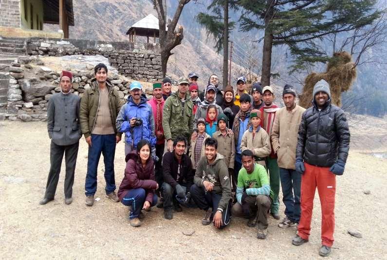
169 ADVENTURE IN UTTARKHAND
170 TREKKING IN UTTARAKHAND Har-ki-Doon Trek This is a beautiful trek through the Govind National Park, which is famous for its wild flowers especially orchids. This area has some of the most beautiful forests. It was made popular by Jack Gibson, a teacher at the Doon school in the late 1940's.The surrounding peaks and glaciers in the Banderpoonch Range are a mountaineer's delight. The Har-ki-dun valley is famous for its flowers and meadows. The path follows the tons river from Netwar village up through the scenic villages of Gangad, Seema and Osla. Har-kidun has many camping places and also a forest guest house. A rest day is ideal to explore the nearby jaundar glacier or make a short excursion to Ruinsara Lake. Duration: 7 Days 6 Nights Best Season: Apr-Jun, Sep-Dec Level: Medium Total Distance: 64 km Maximum Elevation: 3600m Har-ki Dun or 11,135 feet Weather: The nights can be cold. Day temperatures are pleasant during the season Getting from/to: Sankri is connected by road from Dehradun and are about 7 hours drive. Rupin Pass Trek It is a remote and beautiful trek from Uttarakhand (Dhaula) to Himachal Pradesh (Sangla), over Rupin Pass, following the Rupin River. The alpine meadows in the Govind National Park and the views along the way are outstanding. The trek passes through several villages and shepherd camps in the rupin river valley. Rupin is a tributary of the tons river and meets Supin River at Netwar. This part of the Himalayas is very beautiful and has not been spoilt by development. One can witness the Garhwali culture as well as the kinnauri culture. There is a stark difference between the two and the most prominent indicator is the style of houses. During the early summer months it is highly likely that one may encounter snow leading upto the pass. This makes this trek enthralling. Duration: 8 Days 7 Nights Trekking Days: 6 Days Best Season: May - Oct Level: Medium Total Distance: 63 km Maximum Elevation: Rupin Pass m Weather: The higher areas and the nights can be cold, day temperatures are pleasant during the season. Getting from/to: The nearest town is Mussoorie, and is an 8- hour drive from Netwar. The trek can be done from either side. If finishing at Sangla, the drive to Shimla is about 8 hours. Roopkund Trek Roopkund is a mysterious lake in the interiors of district Chamoli.The lake is rather shallow having a depth of about 2m with the edges covered with snow for most parts of the year. When the snow melts;human and equine skeleton remains can be seen, some of them with flesh attached. These remains have been preserved in the alpine conditions for centuries. It is believed that these are the remains of about 300 persons who died about years ago. There are many theories about these findings but none are satisfying. Hence the lake is known as the Mystery Lake. Some believe them to be those of General Zorawar Singh soldiers who died here in a vain attempt to conquer Tibet, while others maintain that they are the skeletons of the zealous pilgrims, who went on the Raja Yatra to the base of Trishul. It is however one of the popular treks in Garhwal as it abounds on spectacular mountain scenery. The trek to Roopkund is very scenic and passes through the magnificent Bedni Bugyal. The trek goes through the outer periphery of the Nanda Devi national park and is one of the best treks to view the magnificent peaks of the Nanda Devi Park. Duration: 6 Days 5 Nights Trekking Days: 4 Days Best Season: May - Sep Level: Medium Total Distance: 48 km Maximum Elevation: Roopkund Lake m Weather: Very cold at nights, days will be pleasant Getting from/to: Nearest road head is Mundoli which is 7hrs drive from Rishikesh. Gangotri-Gomukh-Tapovan Trek The Gomukh glacier is the source of Bhagirathi (Ganges) and is held in high esteem by the devout who do not miss the opportunity to have a holy dip in the bone chilling icy water.gomukh is where the water of Ganga trickles down from the glaciers. The sages called it 'Gomukh', because in the distant past, it probably appeared like a cow's mouth. Tapovan is an ideal location for the tourists looking for peace and adventure.
171 Tapovan is located on an altitude of 4463m / 14640ft above sea level. Tapovan known for its beautiful meadows that encircle the base camp of the Shivling peak, Tapovan is a very pleasant surprised spot with a large meadow complete with bubbling streams, wildflowers and campsites. Herds of Bharal (blue mountain goats) is a common sight from here on mountain ridges. On the far side of the glacier the Bhagirathi I, II, III (6454mt), provide an equally impressive backdrop.every year this place has been visited by thousands of tourist including foreigners for adventure activity like mountaineering & trekking. Duration: 7 Days 6 Nights Best Season: May-Jun Sep-Nov Level: Moderate Total Distance: 30 km Maximum Elevation: 4463m Tapovan Weather: The nights can be cold, day temperatures are pleasant during the season Restrictions: Permit needs to be pre arranged Getting From/To: Gangotri is connected by road to haridwar/dehradoon and is a 10 hr drive. Pindari Glacier Trek Upper reaches of the Kumaon Himalayas host The Pindari Glacier, to the southeast of Nanda Devi, Nanda Kot. The glacier flows to the south for a short distance of about 3 KM and gives rise to the Pindari River which meets river Alakananda at Karnaprayag in the Garhwal district. The trail to reach the glacier crosses the villages of Saung, Loharkhet, crosses over the Dhakuri Pass, and continues onto Khati village, Dwali, Phurkia and finally Zero Point (Pindar) the end of the trail. Though most of the trail is along the banks of the Pindari River, the river is mostly hidden until after Khati, which is last inhabited village on the trail. It is one of the relatively easy to moderate grade trek compared to other Himalayan glaciers. Trail's rugged beauty offers a breathtaking sight to nature lovers in all its pristine glory. The Pindari Glacier is an unsurpassable and an exhilarating experience.. Duration: 10 Days 9 Nights Best Season: Apr-Nov (Except Monsoons) Level: Medium Total Distance: 104 km Maximum Elevation: 3860m Weather: The higher areas and nights can be cold, day temperatures are pleasant during the season. Getting From/To:The nearest town, Bageshwar Bali Pass Trek The Bali Pass trek in the Garhwal Himalayas is a popular trek to Yamunotri. The trek is inside the Govind Wildlife sanctuary, home to a large number of flora and fauna, including many endangered species like Monal pheasant, Himalayan snow cock and others. The trek begins at Sankhari. The destination for the first day is Taluka. The trail is a jeep road along the river Supin The route climbs gently to the village of Dhatmir and the camp for the night is Osla, a large picturesque village. During the trail we cross the rivers of Siyan Gad and Ton. The thick alpine forests of Walnut and chestnut are found here. The journey continues to the Har-Ki-Dun valley, a cradle shaped valley abundant in variety of flowers, alpine birds and animals and panoramic views of the surrounding Himalayan peaks. Views of Kalang peak (6387 m), Bandar punch (6316 m) and Juandhar glacier can be had from here. The journey from Har-Ki-Dun is a gentle downhill traverse to the Debshu Bugyal. The lush green carpeted meadows are a pleasant sight for sore eyes. The trail then continues uphill through a moderate ascent to Ruinsara Tal through conifer forests, and grasslands. A steady climb from Ruinsara tal brings one to the base of Bali pass. The next day is the awaited passing of the Bali pass at an altitude close to 4800 m. After crossing the pass, the route is generally downhill through the meadows and open forests to the Yamunotri shrine. This is a good place to halt and offer obeisance to the deity. The route further is downhill along the Yamuna river through Janaki Chatti and Hanuman Chatti. Hanuman Chatti is the point of motorable roadhead. Duration: 9 Days 8 Nights Best Season: Apr-Nov (Except Monsoons) Level: Medium Total Distance: 84 km Maximum Elevation: 4800m Weather: The higher areas and nights can be cold, day temperatures are pleasant during the season. Getting From/To:The nearest town: Sankri and Hanuman Chatti

172 Uttarakhand Best time to visit Temperature Uttarakhand in general poses a pleasant climate between April to June followed by torrential rain from June to September and then freezing cold from November to March. Entire Uttarakhand Pleasant Moderate April - June October Very cold. freezing : Nov ~ March Mobile phones Postpaid Private and BSNL works in most of the towns like Rishikesh, Haridwar, Badrinath etc., However, in remote places better to have BSNL mobile. All our tours are customizable and hence the itineraries are just suggestive. Do call us for customizing as per your needs.


173 NEPAL Nepal is one mystery kingdom which has everything to offer for a traveler. Awesome views of Everest and Annapurna ranges, wildlife at Chitwan, numerous temples and monasteries at Kathmandu, Patan and Bhaktapur, shopping at Thamel, Himalayas tour from air and the list goes on. No other place is so enchanting like Nepal and this Himalayan Kingdom is the starting point for all high altitude treks and mountaineering, visit to Kailash Manasoravar and Gandaki river to visit Muktinath. Such is the glory of Nepal that it has been recommended as 50 best places to visit before your die. Nepal would enchant you with its glory and should never be missed especially those staying in India which is just next door.
174 BRIEF HISTORY Records mention the Gopalas and Mahishapalas believed to have been the earliest rulers with their capital at Matatirtha, the south-west corner of the Kathmandu Valley. From the 7th or 8th Century B.C. the Kirantis are said to have ruled the valley. Their famous King Yalumber is even mentioned in the epic, Mahabharat. Around 300 A.D. the Lichhavis arrived from northern India and overthrew the Kirantis. One of the legacies of the Lichhavis is the Changu Narayan Temple near Bhaktapur, a UNESCO World Heritage Site (Culture), which dates back to the 5th Century. In the early 7th Century, Amshuvarma, the first Thakuri king took over the throne from his father-in-law who was a Lichhavi. He married off his daughter Bhrikuti to the famous Tibetan King Tsong Tsen Gampo thus establishing good relations with Tibet. The Lichhavis brought art and architecture to the valley but the golden age of creativity arrived in 1200 A.D with the Mallas. During their 550 year rule, the Mallas built numerous temples and splendid palaces with picturesque squares. It was also during their rule that society and the cities became well organized; religious festivals were introduced and literature, music and art were encouraged. After the death of Yaksha Malla, the valley was divided into three kingdoms: Kathmandu (Kantipur), Bhaktapur (Bhadgaon) and Patan (Lalitpur). Around this time, the Nepal as we know it today was divided into about 46 independent principalities. One among these was the kingdom of Gorkha with a Shah ruler. Much of Kathmandu Valley s history around this time was recorded by Capuchin friars who lived in the valley on their way in and out of Tibet. An ambitious Gorkha King named Prithvi Narayan Shah embarked on a conquering mission that led to the defeat of all the kingdoms in the valley (including Kirtipur which was an independent state) by Instead of annexing the newly acquired states to his kingdom of Gorkha, Prithvi Narayan decided to move his capital to Kathmandu establishing the Shah dynasty which ruled unified Nepal from 1769 to The history of the Gorkha state goes back to 1559 when Dravya Shah established a kingdom in an area chiefly inhabited by Magars. During the 17th and early 18 th centuries, Gorkha continued a slow expansion, conquering various states while forging alliances with others. Prithvi Narayan dedicated himself at an early age to the conquest of the Kathmandu Valley. Recognizing the threat of the British Raj in India, he dismissed European missionaries from the country and for more than a century, Nepal remained in isolation. During the mid-19th Century Jung Bahadur Rana became Nepal s first prime minister to wield absolute power relegating the Shah king to mere figureheads. He started a hereditary reign of the Rana Prime Ministers that lasted for 104 years. The Ranas were overthrown in a democracy movement of the early 1950s with support from the-then monarch of Nepal, King Tribhuvan. Soon after the overthrow of the Ranas, King Tribhuvan was reinstated as the Head of the State. In early 1959, Tribhuvan s son King Mahendra issued a new constitution, and the first democratic elections for a national assembly were held. The Nepali Congress Party was victorious and their leader, Bishweshwar Prasad Koirala formed a government and served as prime minister. But by 1960, King Mahendra had changed his mind and dissolved Parliament, dismissing the first democratic government. After many years of struggle when the political parties were banned, they finally mustered enough courage to start a People s Movement in Paving way for democracy, the then-king Birendra accepted constitutional reforms and established a multiparty parliament with King as the Head of State and an executive Prime Minister. In May 1991, Nepal held its first parliamentary elections. In February 1996, the Maoist parties declared People s War against monarchy and the elected government. Then on 1st June 2001, a horrific tragedy wiped out the entire royal family including King Birendra and Queen Aishwarya with many of their closest relatives. With only King Birendra s brother, Gyanendra and his family surviving, he was crowned the king. King Gyanendra abided by the elected government for some time and then dismissed the elected Parliament to wield absolute power.in April 2006, another People s Movement was launched jointly by the democratic parties focusing most energy in Kathmandu which led to a 19-day curfew. Eventually, King Gyanendra relinquished his power and reinstated the Parliament. On November 21, 2006, Prime Minister Girija Prasad Koirala and Maoist chairman Prachanda signed the Comprehensive Peace Agreement (CPA) 2006, committing to democracy and peace for the progress of the country and people. A Constituent Assembly election was held on April 10, On May 28,2008, the newly elected Constituent Assembly declared Nepal a Federal Democratic Republic, abolishing the 240 year-old monarchy. Nepal today has a President as Head of State and a Prime Minister heading the Government and also became secular country instead of Hindu country as known earlier.
175 Kathmandu Valley comprises the three ancient cities of Kathmandu, Patan and Bhaktapur, which were once independent states ruled by the Malla kings from the 12th to the 18th centuries. The three cities house seven UNESCO World Heritage shrines which are together listed as a UNESCO World Heritage Site (Culture). The valley is also home to hundreds of other exquisite monuments, sculptures, artistic temples and magnificent art reminders of the golden era in Nepal s architecture. Legend has it that the valley was was once a primordial lake ringed by verdant mountains. In this pristine lake lived giant serpents until one fine day, saint Manjushree, the Bodhisatva, raised a mighty sword and in one fell swoop, cut open the side of a mountain at a place now known as Chobar. The voluminous waters of the lake gushed out, leaving behind a fertile valley capable of supporting large urban settlements over the millennia. The Gopala and Kirati dynasties were the earliest rulers here followed by the Licchavi ( A.D.), under whom flourished trade and crafts. But the valley s remarkable cities with their ornate palaces, the superbly crafted pagodas and the monumental stupas are testimony of the artistic genius of the Newar craftsmen, the original inhabitants of the valley, whose skills were championed by the Malla kings and appreciated even by the Mongol rulers of 18th century China. Kathmandu Captial of Nepal has lot of interesting places to see and relish. Here is what you can do at Kathmandu apart from shopping at Thamel. 1. Akash Bhairav Believed to have been built in the 12th century, the temple enshrines Akash Bhairav, a ferocious manifestation of Lord Shiva. The three-storey temple with tiled roofs, a hanging balcony, gilded and latticed windows and an artistic doorway lies in the main market avenue called Indra Chowk. 2. Kathmandu Durbar Square (UNESCO World Heritage Site) Situated in the heart of old Kathmandu city at Basantapur, Kathmandu Durbar Square never fails to impress first time visitors with its ensemble of palaces, courtyards and temples built during the Malla period. The Durbar Square includes the Hanuman Dhoka Royal Palace, the historic seat of the royalty; the magnificent Taleju Temple towering more than 40 meters; Kumari Ghar, the residence of the Living Goddess, Kumari; Ashok Vinayak, also called Kathmandu Ganesh, a temple without a filial ; and Kal Bhairav, the God of Wrath. The capital takes its name from the giant pagoda of Kasthamandap, which is said to have been built out of a single tree. Since the time of the Malla kings, the Durbar Square has been the city s social, religious and political focal point. 3. ASAN Once the center of old Kathmandu, the Asan market square is located about midway on the only diagonal thoroughfare in Kathmandu that links Durbar Square with Durbar Marg. At Asan, there are six roads radiating in all directions. The three-storied pagoda style Annapurna Temple of Annapurna, the Goddess of Grains, presides over the ever-lively bazaar. Asan is still an important shopping center and one of the busiest market places with shops selling anything from imported spices to kitchenware, fresh vegetables, Chinese goods, hardware and clothes. 4. Swayambhunath Stupa (UNESCO World Heritage Site) Resting on a hillock 3 km west of Kathmandu, it is one of the holiest Buddhist Chaityas in Nepal. It is said to have evolved spontaneously when the valley was created out of a primordial lake more than 2,000 years ago. This stupa is the oldest of its kind in Nepal and has numerous shrines and monasteries on its premises. 5. Pashupathinath temple (UNESCO World Heritage Site) Situated 5 km east of Kathmandu, the temple of Lord Shiva is considered one of the most sacred Hindu shrines in the world. The two-tiered pagoda with golden roofs and silver doors houses the sacred linga, or phallic symbol, of Lord Shiva. Chronicles indicate the temple existed before 400 A.D. Near the Pashupatinath Temple on the banks of the Bagmati River lies Guheswari, where, according to mythology, a portion of Sati Devi, Lord Shiva s consort, fell when a grief-stricken Shiva wandered aimlessly across the earth carrying her dead body on his shoulders following her self-immolation. 6. Bouddhnath Stupa (UNESCO World Heritage Site) Situated 8 km to the east of downtown Kathmandu, Bauddhanath is one of the most imposing landmarks in Kathmandu, visible as soon as you land at the Tribhuvan International Airport. It is the largest stupa in the Kathmandu Valley and is the center of Tibetan Buddhism. 7. Balaju Garden Three kilometers north-west of Kathmandu lies the Balaju Garden, a quiet park ideal for relaxation just below the Nargarjun hill. The park has a line of 22 stone water spouts built in the 18th century, each of which has an ornately carved crocodile head. During an annual festival, people come here to take a ritual bath. A replica of the stone image of Budhanilkantha was built here specifically for the royal family who were barred from visiting the real one. Above Balaju lies the Nagarjun forest (5 km northwest of Kathmandu). The summit (2,096 m) is a two-hour walk, from where great views of the Kathmandu Valley and a number of Himalayan peaks can be had. There is a Buddhist stupa and a view tower on the summit.
176 8. Thamel As the tourist district of Kathmandu, Thamel bustles with activity late into the night. It is a mere10-minute walk from the center of Kathmandu, yet completely different from the rest of the city. Thamel caters entirely to tourists with its scores of hotels, rows of restaurants and bars, book shops, inviting souvenir shops, cyber cafes and travel agencies. All that a tourist needs can be found here, even friends and traveling companions. 9. Dharahara The soaring landmark of Kathmandu, the Dharahara tower is 50.5 m high and was built by then Prime Minister Bhimsen Thapa in It is open to anyone who can go up after paying the entrance fee. The 360 degree astounding view of the Kathmandu Valley is well worth the long climb up the spiraling staircase. 10. Garden of dreams At the entrance of Thamel, the Garden of Dreams within the Kaiser Mahal complex has now been renovated and restored to its former glory. Major attractions in this 24- acre garden include neo-classical pavilions, fountains, decorative garden furniture, Chinese Moon Gate and European inspired features such as pergolas, balustrades, urns and birdhouses. Today it is open to the public with a restaurant and bar. 11. Budhanilkantha The largest of Vishnu s stone statues, Budhanikantha lies at the foothills of the Shivapuri hills, 8 km north of the Kathmandu city center. The large granite figure of Lord Vishnu, reclining on a bed of serpents known as Nagas, seems to float in a pond. This shrine dates back to the 5th century. 12. Kirtipur It is situated on a ridge 8 km southwest of Kathmandu. The ancient Newar township - with its brick-paved streets lined with typical red brick houses and tiled roofs, and temple squares - is a natural fortress. The Chilamchu stupa and the temple of Bagh Bhairav are major attractions here. Tribhuvan University, Nepal s premier seat of education, is located at the foothills of Kirtpur. 13. Pharping Lying 18 km south of Kathmandu on the valley rim, Pharping is perched on a hilltop with a Buddhist monastery. Pharping s main attraction is an elaborate 17thcentury temple which houses a glided image of Goddess Bajra Jogini. Other fascinating sights here include a cave and a hand-imprint of the Buddhist saint Padmasambhav on the rock face over its entrance. 14. Dakshinkali Four kilometers further south of Pharping on the valley rim is the temple of Dakshinkali dedicated to the Hindu goddess Kali. The shrine is especially crowded on Tuesdays and Saturdays when animal sacrifices are offered to the deity. On the way lies Chobhar gorge. The Bodhisatva Manjushree is said to have cut an incision here to drain out the lake which once covered the valley. There is a small but picturesque temple of Adinath on the top of a hill from where one can have a panoramic view of the snowcapped mountains. Shesha narayan Situated between Chobhar and Dakshinkali, the temple of Shesha Narayan represents one of the four Narayans of the Kathmandu Valley. The other three Narayans are Changu Narayan of Bhaktapur, Visankhu Narayan of Patan and Ichangu Narayan of Kathmandu. Patan Patan, also known as Lalitpur, the city of artisans, lies 5 km southeast of Kathmandu, and is home to the valley s finest craftsmen who have preserved such ancient techniques as the repoussé and lost wax process used to produce exquisite sculptures. The city retains much of the old charm with its narrow streets, brick houses and multitude of wellpreserved Hindu temples, Buddhist monasteries (vihars) and monuments. The predominant sound in Patan is that of the tinkering of craftsmen bent over the statuettes they are shaping. As in Kathmandu, Hinduism and Buddhism have coexisted here for ages, influencing each other, and the religious harmony is exemplary. 1. Patan durbar square (UNESCO World Heritage Site) Like its counterpart in Kathmandu, Patan Durbar Square is located in the heart of the city and was once the palace of the kings of Patan. The square is an enchanting mélange of palace buildings, artistic courtyards and graceful pagoda temples a display of Newari architecture that had reached its pinnacle during the reign of the Malla kings. Among its numerous courtyards, the renovated Keshav Narayan Chowk has been converted into a bronze artifact museum. The Sundari Chowk with the sunken bath of Tusha Hiti is a showcase of exquisite woodcarvings, and stone and metal sculptures. The magnificent Krishna Temple with its 21 gilded spires, built in 1637, and the Manga Hiti, the sunken stone water spout, found in the palace complex are but a few examples of its opulence. The Krishna Temple, built entirely of stone, is said to be the first specimen of Shikhara-style architecture in Nepal. 2. Mahabouddha To the east of Patan Durbar Square is Mahabouddha, an exceptional Buddhist monument of exquisite terra cotta art form. On this 14th-century architectural masterpiece are engraved thousands of images of Lord Buddha. 3. Rudra varna mahavihar Also known as Uku Bahal, it is situated a few steps past Mahabouddha and contains an amazing collection of images and statues in metal, stone and wood. The stone-paved courtyard is enclosed by a two-story building with gilded roofs. The kings in ancient times were believed to have been crowned in this monastery. Many of the treasures offered by devotees can be seen here even today. 4. Hiranya varna mahabihar Dating from the 12th century, the three-storied shrine, also known as the Golden Temple, houses an image of the Buddha inside the courtyard or Kwa Bahal. The monastery is known for its exceptionally fine wood-carvings and repousse work. It is a five-minute walk west and north from the northern end of Durbar Square.
177 Patan.cont 5. Kumbheshwar The temple dedicated to Lord Shiva is the only five-storied pagoda in Patan and one of the only three surviving five-storey temples in the country. A natural spring within the courtyard of this temple built in 1392 is said to have its source in the glacial lake of Gosainkunda in northern Kathmandu. A large gathering of devotees arrive here for a ritual bath on the day of Janai Poornima in August. 6. Jagat narayan The Jagat Narayan Temple on the banks of the Bagmati River at Sankhamul is a tall shikhara-style temple consecrated to Lord Vishnu. Built of red bricks, the temple has many fine images. An attractive metal statue of Garuda mounted on a stone monolith is accompanied by several images of Ganesh and Hanuman. 7. Ashoka stupas There are four stupas, supposed to have been built by Emperor Ashoka of India in 250 BC, marking the four corners of Patan. They are situated at Pulchowk, Lagankhel, Ibahi and in Teta (way to Sano Gaon) respectively. At the time they were built, Buddhism was flourishing in the Kathmandu Valley. 8. Tibetan refugee camp The camp on the outskirts of Patan is a tourist attraction with its souvenir shops that sell handwoven woollen carpets and handicrafts such as prayer wheels, an assortment of belt buckles, wooden bowls and jewelry. The camp also houses a stupa and a number of shrines. 9. Patan industrial estate Situated at Lagankhel near Sat Dobato, it is known for handicrafts such as wood carvings, metalcraft, handwoven woollen carpets and thanka paintings. There is a shopping arcade where handicrafts are on exhibition. Bhaktapur Perched on a hill at an altitude of 1,401 m, Bhaktapur or Bhadgaon, literally the City of Devotees, is a major tourist destination that takes visitors back in time. Bhaktapur lies 12 km to the east of Kathmandu on the Arniko Highway that leads to the Chinese border. Covering an area of 6.4 sq. km, Bhaktapur is still untouched by rapid urbanisation and has managed to retain its brickpaved roads, charming red brick houses and a way of life that goes back to medieval times. This ancient city is also famous for pottery and woodcarving amply displayed on the squares and windows respectively. 1. Bhaktapur durbar square (UNESCO World Heritage Site) Among the three durbar squares, the Bhaktapur Durbar Square is by far the most elegant with its large open space facing south. The 15th century Palace of 55 Carved Windows and the palace entrance, the Golden Gate - a masterpiece in repousse art - have added splendour to this palace square which consists of buildings dating from the 13th century to the 18th century. The extraordinary Durbar Square with its extraordinary monuments reflects the glory days of the Malla dynasty when art and architecture thrived in the three cities of the valley. In front of the palace building are innumerable temples and architectural showpieces like the Lion Gate, the statue of King Bhupatindra Malla mounted on a giant stone pillar and the Batsala Temple. The stone temple of Batsala Devi is full of intricate carvings and is a beautiful example of Shikhara-style architecture. There is a bronze bell on the terrace of the temple, which is also known as the Bell of Barking Dogs. Erected by King Ranjit Malla in 1737, its sounding announced the beginning and end of a daily curfew. 2. Nyatapola temple The unique temple of Bhaktapur, the Nyatapola literally means five storied and rises above the city s landscape as a remarkable landmark. It also has the distinction of having withstood the devastating earthquake of Dedicated to a tantric goddess, the steps leading up to the temple are flanked by stone sculptures of deities and mythical beasts, each 10 times more powerful than the one immediately below. 3. Bhairavnath temple Dedicated to Bhairav, the God of Terror, the three-storied temple of Bhairavnath has only the head of Bhairav in the inner sanctum. Legend has it that the Bhairav s head was cut off by a tantric expert in order to keep him in Bhaktapur. Built in pagoda style, the temple is noted for its artistic grandeur and stands adjacent to the famous five-storied Nyatapola Temple. 4. Dattatreya square It takes its name from the Dattatreya Temple dedicated to a three-headed combination of the Hindu deities Brahma, Vishnu and Shiva. This temple is said to have been built from the trunk of a single tree. Near this temple is a monastery with exquisitely carved peacock windows. 5. Siddha pokhari For a small city, Bhaktapur has the largest number of public water tanks built within the city limits. Siddha Pokhari, which dates back to the Lichhavi period, is situated at the bus stop. This large rectangular pond teems with fish and has stone images of different Hindu and Buddhist gods on the walls surrounding it. 6. Thimi It is a Newar town situated about 8 km east of Kathmandu on the way to Bhaktapur. Besides farming, most of the households here are engaged in pottery. This laid-back town not only supplies Kathmandu its pottery but also its vegetables. The two important deities here are those of Balkumari Temple, dedicated to the Mother Goddess, and Karunamaya, the Buddha of Compassion. 7. Surya binayak The temple dedicated to the Hindu deity Ganesh. Situated in a thick forest to the south of Bhaktapur, it is a 20-minute walk from the bus stop.
178 Suriya binayak..cont The temple is crowded with devotees especially on Tuesdays and Saturdays. 8. Tibetan refugee camp The camp on the outskirts of Patan is a tourist attraction with its souvenir shops that sell handwoven woollen carpets and handicrafts such as prayer wheels, an assortment of belt buckles, wooden bowls and jewelry. The camp also houses a stupa and a number of shrines. 9. Changu narayan temple (World Heritage Monument) It is situated on a ridge overlooking Bhaktapur, about 12 km to the east of Kathmandu. Dedicated to the Hindu god Vishnu, it is one of the oldest specimens of pagoda architecture in the valley. The temple dating from the Licchavi period is embellished with exquisite wood and stone carvings. Nagarkot Nagarkot is located 32 kms, east of Kathmandu. From here, visitors could have unrestricted view of the mountain range from Annapurna in the west to the mighty Everest in the East. Historically, Nagarkot was a place for the royals of Nepal to escape the scorching heat of summer and a hectic city life. In the 60 s explorers would battle the shivering winds and sleepless nights to see the stupendous sunrise and sunsets. Today, still people from all over World, from different walks of life, travel to Nagarkot, to enjoy the picturesque rural scenery of terraced rice fields, green pastures, the sunrise and sunsets Air ride of Himalayas While at Kathmandu, you can take an hour flight ride from 6:00 AM onwards to see Himalayan region in full splendor. All the ranges including Makalu, Lhotse, Everest and Choy Oye, can be seen photographed and filmeed. As the aircraft takes off and heads towards the east, you won't have to wait long to find out what's in store for you. First to your far left you will see Gosaithan, also called Shisha Pangma, standing at the majestic height of 26,290 feet (8,013 meters). Immediately to the right of Gosaithan, you will Dorje Lhakpa appear (22,000 feet or 7,000 meters), a mountain that almost looks like a figure 8 lying in the snow. To the right of Dorje Lakpa is Phurbi- Chyachu, which looms over the Kathmandu Valley. As the plane glides along, the mountains come closer and closer. Next on the vision is Buddha Air Mountin Choba-Bhamare, the smallest mountain of the lot, but singularly stubborn as it has never been climbed. Then appears the mountain that is not only prominent in sight but also in its spirituality, Gauri-Shanker. Lord Shiva and his consort Gauri are said to protect this mountain, which was first successfully climbed only in The mountains of Melungtse and Chugimago are next on the tour, the latter of which is still waiting to be climbed. Numbur and Karyolung, an intensely white mountain, will gleam with the rising sun as we carry on deeper into the mountain range. We will then pass Cho-Oyu, the sixth highest mountain in the world, reaching a height of 27,000 feet (8,201 meters). Gyachungkang, Pumori and Nuptse, each over 22,000 feet (7,000 meters) in height, will mark our path towards the highest mountain of them all: Mount Everest. Known as Sagarmatha by the Nepalese and Chomolungma by the Tibetans, this unbelievable mountain stretches 29,029 feet (8,848 meters) into the sky. Much has already been written about Everest, but to actually witness it face to face during a mountain flight is something else. Even while it looms there in front of the eyes, it remains a remarkable place, this highest spot on earth. Though Mountain Flight is enjoyed by thousands all the year round, our experience says that it is highly recommend time period from February to April and October & November as prime time to enjoy the mountain flights. Pokhara Pokhara s bewitching beauty has been the subject of many travel writers. Its pristine air, spectacular backdrop of snowy peaks, serene lakes and surrounding greenery make it the jewel in the Himalaya, a place of remarkable natural beauty. With the magnificent Annapurna range forming the backdrop and the serenity of three major lakes Phewa, Rupa and Begnas Pokhara is the ultimate destination for relaxation. Pokhara Valley, gateway to the Annapurna region where many a trekker finds his Shangri-la, sits high on the list of must visit places in Nepal. Pokhara once lay on the important trade route between India and Tibet. To this day, mule trains set up camps on the city outskirts, bringing goods from remote Himalayan regions including Mustang. Gurungs and Magars, who have earned worldwide fame as fierce Gurkha warriors, are predominant here. Thakalis, indigenous of the Thak Khola region of Mustang, are known for their entrepreneurship and run tea houses along the trek routes in the Annapurna region. 1. Mountain Views Pokhara is blessed with stunning panoramic views of the Annapurna range which forms its backdrop. The mesmerizing Machhapuchhre also called Mt. Fishtail dominates the scenery because of its proximity to the valley and can be seen from anywhere in Pokhara. Stretching from east to west, the Annapurna massif includes Annapurna 1 to IV and Annapurna South. Further away are seen the giants, Dhaulagiri (8,167m) and Manaslu (8,163m).
179 2. Phewa Lake Pokhara owes its popularity to the enchanting Phewa Lake, and along its eastern shore has grown the Lakeside or Baidam, a thriving resort town of hotels, restaurants, bars and souvenir shops that allow travelers to relax and enjoy. Phewa Lake is the largest and most beautiful of the three lakes, attracting a large number of visitors who enjoy boating on its placid waters. Boats can be hired, and many visit the island temple of Barahi in the middle of the lake. 3. Barahi Temple Located in the middle of Phewa Lake, Barahi Temple is one the most important monuments in Pokhara. The two-storied pagoda is dedicated to the boar manifestation of Ajima who represents the female force, Shakti. Sacrifices take place here, and the largest crowds of devotees are seen on Saturdays. 4. Seti An amazing aspect of Pokhara is the vanishing river, Seti, which goes underground and disappears in many places along its route through the city. At various points Seti is barely 2 m wide but its depth reaches an astonishing 20 m! A good spot for watching the river is Mahendra Pul at Bhimsen Chowk, a bridge near the old Mission Hospital. Here the river can be seen in all its ferocity gushing down the deep gorge that it has carved over millennia. 5. Devi s Fall Locally known as the Patale Chhango (Nether Fall), Devi s Fall is a fascinating waterfall located about 2 km south-west of Pokhara Airport on the Siddhartha Highway. 6. Mahendra Gupha This is a large limestone cave at a two-hour walk to the north of Pokhara. Locally known as the House of Bats, it is famous for its stalactites and stalagmites. 7. World Peace Pagoda The World Peace Pagoda can be seen on top of a hill on the southern fringe of Phewa Lake. It has four images of the Buddha facing the four directions. The dome-shaped pagoda is an impressive sight, and its hilltop location commands a great view. It is a great vantage point which offers spectacular views of the Annapurna. 8. The Old Bazaar A stark contrast to Lakeside Pokhara, the old Pokhara Bazaar, 4 km away from Phewa Lake, is a traditional bazaar and a colorful gathering place for an ethnically diverse group of traders. The temples and monuments bear a close resemblance to the Newari architecture of the Kathmandu Valley. The old bazaar is also home to one of Pokhara s most important shrines, the Bindhyabasini Mandir, a white dome-like structure atop a hill. Beyond Pokhara Sarangkot It (1,592 m) is a former Kaski fort atop a hill 5 km west of the old bazaar. Overnight visit to Sarangkot offers a grandstand view of sunset and sunrise over the Annapurnas. Kaskikot/Naudanda It (1,500 m) lies about three hours from Sarangkot or 15 km west from Pokhara. It is a soft walk through green hills and ancient ruins with good views of Phewa Lake, Pokhara Valley and the mountains. Kahundanda (1,520 m) To the northeast of Pokhara, is a ruined fort on the summit with a view tower that offers spectacular scenery. It is an opportunity to walk though deciduous forests and savor rural life. Spectacular views of the Seti River and sunrise and sunset are the high points. Ghalchowk A five-hour walk to the north of Pokhara, is a typical Gurung village and is one of the region s oldest settlements. Sirubari It is a small village nestled on the southern slopes of a ridge at 1,700 m. The village is a 5-hour walk from Pokhara, about 20 km to the northeast.. The village inhabited by the Gurungs is small and compact with neat and clean trails connecting the mainly stone and slate-built houses. Sirubari won the PATA Gold Award in 2001 for its initiative to preserve heritage and culture. Chitwan Chitwan literally means heart of the jungle. In recent years Chitwan tops the list of things to do in Asia. It is a truly wildlife adventure of a different kind jungle safaris on elephant backs or jeeps, birdwatching, canoe rides and jungle walks. The Chitwan National Park is Asia s best preserved conservation area, where wildlife thrives and their habitats remain intact. Only half-hour flight from Kathmandu, the park lies in the Inner Terai lowlands and consists of Sal forests, tall elephant grasslands, hills, ox-box lakes and flood plains of the Narayani, Rapti and Reu rivers. Enlisted as a UNESCO World Heritage Site (Natural) in 1984, the park spreads over an area of 932 sq. km. Experiencing wildlife: The park is home to 56 species of mammals, 49 species of amphibians and reptiles, and 525 species of birds. Wildlife found here include endangered species like the onehorned rhinoceros and the Royal Bengal tiger, gaur, wild elephant, four-horned antelope, leopard, sloth bear, wild boar, rhesus monkey, grey langur monkey, wild dog, small wild cats, and many other smaller animals. Also found here are cobras, kraits and pythons. The swampy areas and numerous oxbow lakes of Chitwan provide a home for the marsh mugger crocodiles. In a stretch of the Narayani River are found one of the few remaining populations of the rare and endangered fish-only eating gharial, or Gangetic crocodile. Also found here is one of the world s four species of freshwater dolphins. Birdwatching The park is a great place to watch colorful birds like woodpecker, hornbill, Bengal florican and redheaded trogon.
180 Winter birds such as waterfowls, Brahminy duck, pintails and bareheaded geese are drawn by the sanctuary of the park s rivers. In summers, the forest is alive with nesting migrants such as the fabulous paradise flycatcher, the Indian pitta and parakeets. Winter birds include migratory birds from Siberia. Jungle safari A typical 2-nights/3-days jungle safari includes wildlife safari on elephants, canoe ride to watch the crocodiles and water birds, rural tour to view the lifestyle of the indigenous Tharu people, and nature walks to see the exotic flora and fauna. Apart from the jungle safari, the Elephant Breeding Center and Gharial Crocodile Farm, where these animals and reptiles have been successfully bred in captivity, are worth a visit. Visiting Devghat About 6 km to the north of Bharatpur, on the way to the Chitwan National Park, is a prominent pilgrimage site Devghat, at the confluence of the Trishuli and the Kali Gandaki rivers, which then form the Narayani, a major tributary of the Ganga. Confluences of major rivers such as these are considered very holy. On the day of Makar Sankranti, the first day of the Nepali month of Magh in January, pilgrims converge here to take holy dips. There are a large number of shrines, temples, ashrams and old age homes at Devghat. Balmiki Ashram was a retreat used by the great Hindu sage Balmiki, where Sita came to live with her two sons Lav and Kush after separating from Ram. The ashram is situated in a forest on the bank of the Tribeni River, at the southwestern corner of the national park. Trekking Chepang hill trail Chitwan midhills, home of the indigenous Chepangs, provide interesting trekking tours leading to rustic Chepang villages, birdwatching opportunities and wonderful views of the mountains and the surrounding hills and plains. The trail can be started or ended at Hugdi that lies on the Kathmandu-Chitwan highway, and one can go rafting on the Trishuli River upto this point. The other end of the trail is Shaktikhor. Lumbini Lumbini, the birthplace of Lord Buddha, in the Terai plains of Nepal is one of the greatest pilgrimage sites for Buddhists. More than 400,000 Buddhists and non Buddhists visit Lumbini every year. It is also a UNESCO World Heritage Site (Culture) and holds immense archeological and religious importance. Sacred Garden It was here in the gardens of Lumbini that Prince Siddhartha Gautam, who later became the Buddha, was born in 623 BC. The nativity site is marked by a commemorative pillar erected by Mauryan Emperor Ashoka of India during his pilgrimage to the holy site in 249 BC. The inscription on the Ashoka Pillar indentifies the Sacred Garden - spread over 9 sq. km as the spot where the Enlightened One was born. A large number of Buddhist pilgrims from all over the world visit Lumbini to pray at the Mayadevi Temple where excavations have revealed the marker stone showing the exact spot where Siddhartha Gautam Buddha was born. The sacred Puskarni Pond where Queen Mayadevi had taken a bath before the birth of Buddha lies to the south of the pillar. It was also in this pond that the infant Buddha was given his first bath. Monuments: To the north of the Sacred Garden are monastic zones where different countries have built temples and monasteries depicting different sects of Buddhism. The Myanmar Temple (Lokamani Cula Pagoda) is a shiny gold and white structure that resembles the Shwe-dagon Pagoda of Yangon while the International Gautami Nuns Temple is a replica of the Swayambhu Stupa of Kathmandu. The China Temple, built by the Buddhist Association of China, is a complex of pagodas, prayer rooms and meditation cells. Across the road is the Dae Sung Suk Ga Sa Korean Temple. The Japan Peace Stupa, built by Nippon Jon Kyohoji of Japan, is a 41- m tall structure with four different Buddha statues set into the stupa s dome facing the four cardinal directions. Other beautiful monuments and temples have been built by Vietnam, Thailand, Mongolia, France, Germany and Sri Lanka. You could plan a Buddhist Circuit tour as follows: There are 62 archaeological sites scattered around Lumbini. The tour goes through Tilaurakot, Kudan, Gothihawa, Niglihawa, Sagarhawa, Aurorakot, Devadaha and Ramagrama - all bearing significance to the life and enlightenment of the Buddha. 1. Tilaurakot Identified by archaeologists as the capital of Kapilvastu, Tilaurakot lies 27 km west of Lumbini, where excavations are on to unearth the ancient palace of King Suddhodhan, Siddhartha Gautam s father. The Buddha is believed to have spent the first 29 years of his princely life in Tilaurakot. 2. Kudan Located some 4.5 km south of Tilaurakot, Kudan is where King Suddhodhan met Lord Buddha for the first time after returning from his enlightenment. It was here that the Kasaya (yellow robe worn by monks) was presented to Lord Buddha. It was also here that the Kasaya was presented by Lord Buddha to Rahul, his son. 3. Gothihawa About 5 km from Tilaurakot, Gothihawa is where Krakuchanda Buddha, who preceded Shakyamuni Buddha, was born. Remains of a broken Ashoka Pillar and relics can be seen here. 4. Niglihawa About 8 km from Tilaurakot, Niglihawa is where Kanakmani Buddha was born. Here too one can see remains of a broken Ashokan Pillar.
181 5. Devdaha The capital of the Koliya kingdom and maternal home of Mayadevi, Devdaha is 35 km to the northeast of Lumbini. This is where Siddhartha Gautam spent his childhood. 6. Sagarhawa Forest site is identified by archeologists as the Palace of the Massacre of the Shakyas by the invading forces. The ruins of the ancient site lie on the west and south banks of a large rectangular pond known locally as Lumbu Sagar, or long pond, in Niglihawa village. Sagarahawa is 12 km north of Taulihawa municipality in Lumbini. Lumbini Village Tour A walk through the villages surrounding Lumbini and interaction with the warm and hospitable local people, buying their handicrafts and observing their traditional rituals will bring one closer to understanding the diversity of the Terai cultures in Nepal. Village tours also give an opportunity to observe the Terai landscape and a peek into the locals agro-based rural lifestyle, colorful costumes, festivals which they celebrate with much joy and enthusiasm, and gracious hospitality. Visitors can also visit the local temples and mosques or partake in the cultural ceremonies. Janakpur Janakpur, the birthplace of Janaki or Sita, the consort of Lord Ram, is an important religious pilgrimage site in the Terai plains, in south central Nepal. In ancient times, Janakpur was the capital city of the Kingdom of Mithila and the centre of Maithil culture during the Treta Yug, or period, nearly 12,000 years ago. Janakpur has held a special significance for Thai Royal families since ancient times. The Royal household of Thailand still receives mangoes from the orchards of Janakpur. These fruits which are in abundance only during the peak summer months from May to mid June are savored for their sweet taste and unique flavor. Janaki mandir Pilgrims flock here by the thousands to pay homage at the massive and magnificent Janaki Mandir Janaki being the other name of Sita, the daughter of King Janak. The temple was constructed in 1874 and is a blend of Mughal and local architecture. The temple is a three-storey building and has 60 rooms, making it the largest temple in Nepal. The temple houses an idol of Sita which was found near Ayodhya, the kingdom of Ram. The marriage anniversary of Lord Rama and Sita is celebrated in Janakpur every year on Vivah Panchami day which falls in December. In the southwest corner of Janaki Mandir is the Vivah Mandap, which has been built at the site where the marriage of Ram and Sita is said to have been taken place. Another well-known temple in the vicinity is Ram Mandir, built in pagoda style, and hence is different from the other temples in Janakpur which generally bear resemblance to Mughal architecture. It houses a female statue, said to be of Yogamaya, which has the reputation of being one of the most beautiful images of female forms in Nepal. Other holy sites of interest include the Laxman Temple, Sankat Mochan Temple and Hanuman Temple. Ponds The Mithila region prides itself in having a large number of ponds. Janakpurdham is said to have as many as 115 ancient ponds of historical and mythological importance. Among the ponds, Ganga Sagar, Parshuram Kunda and Dhanusha Sagar are held extremely sacred. Around Janakpur 1. Dhanushadham: Situated 18 km north-east of Janakpurdham, Dhanushadham, is believed to be the place where the broken remains of the divine Shiva bow fell after Ram broke it to obtain Sita's hand in marriage. A fossilized fragment of the broken piece is still believed to be present here. Every Sunday in the month of Magh (January/ February), a Makar Mela (fair) takes place - a tradition that has not been broken since Vedic times - and tens of thousands devotees from Nepal and India flock here to pay homage to this place. 2. Parshuram kunda It is said to be the pond where Maharishi Parshuram bathed to quell his anger after his confrontation with Ram over the breaking of the sacred bow of Shiva. It lies 4 km west of Dhanushadham. The pond is picturesque, with lotus flowers floating on it and lush trees on its southern banks. 3. Jaleshwar Toward the south of Janakpur near the Indian border is Jaleshwar, famous for Shiva temple known as Jaleshwar Mahadev. The Shiva lingam here is situated about 20 feet below the surface of the temple and is reached by a narrow stone stairway. Most of the time it lies immersed in water, hence the name Jaleshwar, which literally means Lord of the Water. There are two large ponds on either side of the temple.


182 Lions at Bhaktapur Bodhnath temple


183 Durbar Square, Patan Devi s falls at Phewa lake, Phokara


184 Phewa Lake at Pokhara Mahendra Caves at Pokhara


185 Pashupathinath temple, Kathmandu Chitwan Elephant Camp, Chitwan


186 Annapurna from Pokhara Ashoka Stupa, Patan


187 Annapurna ranges from Nagarkot Lumbini Palace temple, Lumbini


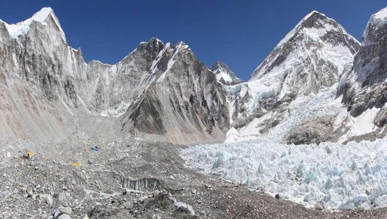
188 ADVENTURE IN NEPAL
189 Everest Base Camp Trek Nowhere in the world is more spectacular than in the Everest region. It is where four of the world's six tallest peaks Mt. Everest, Mt. Lhotse, Mt. Makalu, and Cho Oyu rise above everything else, crowning the towering ridges that straddle the forbidding Himalayans. The Everest Base Camp trek is the grandest walk in the land of the Himalayas. Trekking through the Everest region offers astounding mountain views, and opportunities to get a glimpse into the life of world famous climbers (the Sherpas). The trek further offfers the opportunities to go sightseeing around Sagarmatha National Park, a world heritage site that is home to a variety of Himalayan floras and faunas, to get a closer look at the highest Buddhist monasteries in the world, and, of course, the most gratifying of them all, the trip to Everest Base Camp itself. It is an opportunity to embark on an epic journey that Sir Edmund Hillary and Tenzing Norgay set off on in But nothing beats the thrill and sense of accomplishment that grips travelers on seeing the power and grace of the mighty Everest up close. With a thrilling ride to Lukla from Kathmandu, you start trekking to Namchi Bazaar and reach Kalapathar in this 17 day trek route. Truly memorable and never to be missed. On the way, you would see Ama Dablam and other mountains while you have first hand experience of Everest region. Duration: 17 days Best Season: April June Level: Difficult Highest Point : Kalapatthar at 18,449 feet and highest camp at Gorak Shep 17,009 feet. Highlights Kumbhu Icefall and camp at EBC Accommodation: Tea House and camping. Everest Base Camp to Gokyo Lake This is something which is for those who not only want to enjoy Everest panorama but also get into an offbeat mood. Gokyo Lakes trip takes adventurous trekkers to fabulous Gokyo Valley, source of grand Dudh Koshi River - the large Ngojumba Glacier, the famous Cho La pass, and the celebrated view points of Gokyo Ri and Kala Patthar along with Everest Base Camp. Many trekkers yearn to visit the Gokyo valley as a side trip during their Everest Base Camp Trek and they feel their Everest trek incomplete if they happen to miss the trip to Gokyo Valley, Gokyo Peak, and the famous pass, Cho La. The entire area is blessed with abounding natural beauty of shimmering Lakes. Beyond peace of mind at the tranquil appearance of the glacial Lakes, we can enjoy 360 degree panoramic views of four above 8000 m massifs and other mountain ranges from the best view point of Everest Region, the Gokyo Ri - because panorama from here is more spectacular than that from Kala Patthar viewpoint. Duration: 18 days Best Season: April June Level: Difficult Highest Point : Kalapatthar at 18,449 feet and highest camp at Gorak Shep 17,009 feet. Highlights : Everest and Gokyo Ri Accommodation: Tea House and camping. Restrictions: NONE. Sagarmata National Park fee has to be paid Annapurna Base Camp Trek Mt. Annapurna (8091m) is the 10th highest mountain in the world and the journey to its base camp is one of the most popular treks on earth. Like any other trip in the Annapurna region, our trek also begins in Pokhara, widely known as the Lake City and passes through cascading waterfalls, beautiful villages, terraced farmlands, lush rhododendron forests, and amazing mountain vistas before reaching the base of the mighty Annapurna. The setting of the Annapurna Base Camp at 4130 m is unique and incredibly spectacular, set amidst the mighty peaks of Annapurna I (8091 m), Annapurna South (7219 m), Machapuchhre (6993 m) and Hiunchuli (6441 m). The Annapurna Base Camp Trek takes 7 to 11 days, depending on your itinerary and length of walking days. The itinerary presented here takes 11 days, starting from Nayapool at 1 1/2 driving from Pokhara, and going north up till Gorepani and the famous viewpoint of Poon Hill. From Gorepani you go eastwards to Chomrong and then north again, entering the Modi Kola Valley up till the Base Camp. Many people only trek the circuit Nayapool-Ghorepani-Ghandruk- Nayapool, which is very rewarding in itself. This trek can easily be done with children as well. You can return via Jhinu Danda, and give your tired muscles a well deserved rest in the delightful hot springs. Upon your return it is worthwhile visiting one of the Gurung villages of Ghandruk or Landruk. Annapurna Base Camp trek is easier when compared to Everest Base Camp Trek and hence one can add Poon Hill Trek along with Annapurna to add spice to this trek.


 Today we head to Kodari which is Nepal-Tibet boarder by private vehicle/ bus. The drive is scenic views of green fields, hills and mountains.")

190 KAILASH MANASAROVAR TOUR BLISS AT 19,500 FEET Day 01: Arrive in Kathmandu (1350 m) Himalayan Fantasy team will welcome at the Tribhuvan International Airport, Kathmandu, Nepal. We will meet you and greet you and accompany you to the hotel for check-in and rest. Overnight at Hotel. Day 02: Sightseeing around Kathmandu visit temples We will go for half-day sightseeing tour of Kathmandu. Visit Pashupatinath Temple, Guheshwori Temple and Budhanilakantha (lying Bishnu Temple). Final preparation for Holy Kailash Yatra/ pilgrimage tour i.e. checking the equipment which will be used during the tour. Our team would help you in case you want to buy last minute items like sweaters, wind-cheaters, gloves etc. Briefing would be done for the much awaited tour. Day 03: Drive Kathmandu to Nyalam 3750 m (156 km) Today we head to Kodari which is Nepal-Tibet boarder by private vehicle/ bus. The drive is scenic views of green fields, hills and mountains. We also cross rivers like Indrawati, Sunkoshi, Bhote Koshi. It takes almost 4 hours to reach Kodari border. After all immigration and custom formalities at the Nepalese side, we cross the friendship bridge which is borders of Nepal and Tibet/China. The walk from Nepal side to reach the Jeep/ Land Cruiser of Tibet is about 1.5 km. Tibetan Guide will come with document at immigration next to friendship bridge and Zhangmu. We will further continue to Nyalam and Rest. Overnight at guesthouse. Friendship bridge at Kodari to pass to Nepal Nylam Transit stop in Shigatse, Tibet Another view of Friendship bridge Koshi River on way to Kodari Day 04: Nyalam free day for acclimatization. We will hike to hill in slow pace which helps for acclimatization in altitude. It helps us to acclimatize fast and also gives us shape to go for Kailash Kora/ Parikrama. Drinking water, soups, juice would also help us to acclimatize. Overnight at guesthouse. Day 05: Nyalam Dongba/ Saga 4500 m (330 km) (Cross the pass Tong La 5120m and Lalung-La 5050m) (6 hrs) As we start our journey on the left we see Shisapangma (8013m), Phola Ganchen (7661m), Langtang range and Gaurishankar bows our head and heart can feel freshness. Today we cross the pass Tong La 5120m and Lalung-La 5050m. We will meet and cross many lakes and rivers. Among them Lakes like Khumen Tso, Korru Ochen Tso, Peiku Tso and Lodu are near by the road. Chungkar and Lapuk Monastery are opposite side of Lake Peiku Tso. There are Village settlements like Yarleb, Siling and Sashik where we can see local Tibetan house, people and culture. We will cross Bramhapurtra river and Saga. Saga in Tibetan means Happy Land. Overnight stay at guest house in Dongba.

 is longest driving day as we")
 by Land Cruiser/ Jeep.")
, Trugo Gompa (Gelukpa), Gotsuk")


191 Sleepy old town of Saga, Tibet Tong La at 16,900 feet on way to Saga Lalung La Shishapangma from Tong La Day 06: Dongba/ Saga Mansarovar 4558 m (277 km) Today we cross Lake Gung gyu Tso which is at 4622m. Driving to Holy Lake Mansarovar (4560m) is longest driving day as we go kora/parikrama (going around putting on right hand side.) by Land Cruiser/ Jeep. While circumnutating/ Kora of Holy Lake Manasarovar we come across Seralung Gompa, Nyego Gompa (Ruin), Trugo Gompa (Gelukpa), Gotsuk Gompa and finally halt at Chiu Gompa. We also will see Holy Mt. Kailash for the first time. You will feel your visit/ tour to Kailash is almost completed. Your dream will come true after having darshan of Mt. Kailash and having holy bath at Manasarovar. Lake Manasarovar is the fresh water lake where fishes and swans live together. We will also have view of Mt. Gurula-Mandala and Lake Rakshash.Sthal Overnight at guesthouse. Gunggyo Tso on way to Manasoravar Near Chiu Gompa on way to Manasoravar Enthralling Manasoravar. Never feels like coming back from this spot First sight of Kailash from Manasoravar

 Diraphuk (4860 m.")

 (18 km trek / 9-10 km) (passing through Dolma-La pass 5,630m.) Today is the hardest day of Kora/ Parikrama or Yatra itself.")
192 Day 07: Manasarovar Darchen (40 km) We will have holy/ritutal bath and homa/ puja at the bank of Lake Manas in the early morning. We come across the till village called Barkha. Today we will drive to Darchen which is considered as the base camp of Holy Mount Kailash. It is the shortest day to drive for only one and half hour today. On time permission we can visit Chu Gompa. On the side trip paying extra to the driver we can arrange de-tour to Austapad and Trithapuri. Overnight at guesthouse Another view of Manasarovar Kailash from Darchen Day 08: Darchen Darboche (13 km drive) Diraphuk (4860 m.) (7 km trek / 5 6 hrs) Today we come across Selung Gompa before reaching Darbochhe which is called valley of Gods. We drive for around 13 km from Darchen to Darboche. It is the point our trek/ hike/ Parikrama on foot starts. We can hire horse, horse-man and helper as per your need to make your Yatra/ tour more comfortable. The distance of 7 kilometers of walk/trek/ride from Darboche to Diraphuk will take around 5 to 6 hours. Overnight at guesthouse. Parikrama begins at Darboche Yam Dwar Day 09: Diraphuk Zutul-puk (4760 m) (18 km trek / 9-10 km) (passing through Dolma-La pass 5,630m.) Today is the hardest day of Kora/ Parikrama or Yatra itself. From Diraphuk we climb up (ascend) till pass Dolma-La (5630m). The ascending (going up) is less difficult than descending (coming down) as all Yatris/ Pilgrim have to walk getting off from the horse. The walk is for about 9 to 10 kilometer on loose stone. It is always good to carry good trekking shoes which protects your ankle at this point. We will visit Gauri Kund and come across Parvati-stal, and shall be seeing it from a distance. The most fascinating point of this tour is that we shall pass many caves. It is believed that Milerappa once visited here and performed many miracles. Overnight at guesthouse.
 Dongba/ Saga (end of Kailash Parikrama/Kora) The Last day of Kailash Parikrama/ Kora is")


193 Frozen Dolma La or Gauri Kund Mt.Kailash inner parikrama Saptarshi caves Day 10: Zutul-puk Darchen (10 km / 4-5 hrs) Dongba/ Saga (end of Kailash Parikrama/Kora) The Last day of Kailash Parikrama/ Kora is easy walking on beautiful valley. We will walk for about 3 to 4 hours where our Jeeps will be waiting for us to bring us back to Mansarovar. Here we can refill the water to take back home. Overnight at guesthouse. Zutulpuk Gompa Last parikrama Landcruiser waiting at Manasoravar Day 11: Drive Dongba to Nyalam (376 km) 7-8 hrs. Today we will drive in good road for 7 to 8 hour from Dongba to Nyalam. The distance of driving is around 376 Km. Overnight at Guesthouse. Day 12: Drive Nyalam to Kathmandu (156 km) 6-7 hrs. Today again we will finish all formalities at immigration in Tibet and Nepal and will reach Kathmandu in the late afternoon. In the evening after dinner we will have meeting and wants feedback from all Yatris to there Holiest and toughest journey/yatra in the world. Congralution!!! to all those Yatirs who have completed the Holy Kailash Yatra and welcome to new Yatirs who want to accompany us. We will treat you as our own family member and bring you safe back home. Overnight at Hotel Day 13: Fly back home and stay as long as you wish doing tours/ Yatra in Nepal. We will take you to international airport for your onward flight or you can continue other tour (Yatra) in Nepal.
194 Nepal Best time to visit Spring (between March May): The temperature is mildly warm in low lands while moderate in higher altitudes with plenty of opportunities to have tryst with the mountain views. It is also the time for flowers to blossom and the national flower of Nepal rhododendron sweeps the ascending altitudes with its magnanimous color and beauty. Summer (between June August): This is also the monsoon season in Nepal. The weather is hot and wet at times. It rains almost everyday with occasional thunderstorms in the evening. The rain spreads the pleasantness around with lush green vegetation. Autumn (between September November): This is the best tourist season in Nepal with the summer gone by and the winter to set in. The weather is highly pleasant so are the mountain views. This is the peak season for trekking as mountain views are guaranteed so better book your flight in advance. This is also the season of festivities as Nepal celebrates the biggest Hindu festivals Dashain followed by Tihar. Winter (between December February): The weather is cool and the sky is clear with occasional snowfalls at higher elevations. This season is good for trekking in lower elevations. The morning and night is cold and the days are warm when sunny. Temperature Spring season ranges between Degree Celsius (61-73 Degree Fahrenheit) Summer season ranges between Degree Celsius (73-77 Degree Fahrenheit) Autumn season ranges between Degree Celsius (59-75 Degree Fahrenheit) Winter season ranges between 9-12 Degree Celsius (48-54 Degree Fahrenheit) Mobile phones Indian SIM works only in border districts with Nepal. You need to have Nepalese SIM or Long distance call facility to call from Nepal. For detailed itineraries, please visit: All our tours are customizable and hence the itineraries are just suggestive. Do call us for customizing as per your needs.
195 ABOUT TIBETAN BUDDHISM Of the tours and treks I ve made to various Himalayan abodes, every time monasteries and its architecture fascinates me when the paintings unveil the true meaning of what those symbols and thangkas depict. However, since these intricacies are not explained or not depicted, people generally feel that after travelling such long, there was nothing much to see, but in reality they missed the essence of these gompa s or monasteries and paintings. Especially true when you visit Bhutan there are Dzongs and if you are not knowing what each Dzong depict and its architecture, then you would have travelled 180 plus kilometer and then come out of that place in just minutes time. Considering this, wanted to bring out what each aspects are including the pictorial representation, various statues you see in these places, the different sect of Tibetan Buddhism and finally to provide some light on what Buddha stated and how it is depicted in these beautiful and remote monasteries plus why these monasteries are established in elevated and isolated places. Let me first begin with Buddha s view of nature after his nirvana. Buddha expounded 4 noble truths after his enlightenment as follows: 1. The truth of dukkha (conditioned by suffering, anxiety and un-satisfactoriness 2. The truth of the origin of dukkha 3. The truth of the cessation of dukkha 4. The truth of the path leading to the cessation of dukkha The first truth explains the nature of dukkha. Dukkha is commonly translated as suffering, anxiety, unsatisfactoriness, uneasyness, etc., and it is said to have the following three aspects: The obvious suffering of physical and mental illness, growing old, and dying. The anxiety or stress of trying to hold onto things that are constantly changing. A subtle dissatisfaction pervading all forms of life, due to the fact that all forms of life are changing, impermanent and without any inner core or substance. On this level, the term indicates a lack of satisfaction, a sense that things never measure up to our expectations or standards. The second truth is that the origin of dukkha can be known. Within the context of the four noble truths, the origin of dukkha is commonly explained as craving (Pali: tanha) conditioned by ignorance (Pali: avijja). On a deeper level, the root cause of dukkha is identified as ignorance (Pali: avijja) of the true nature of things. The third noble truth is that the complete cessation of dukkha is possible, and The fourth noble truth identifies a path to this cessation. This can be achieved by following 8 fold path. Division Factors Text in Pali / Sanskrit Explanation Wisdom (Sanskrit: prajñā, Pāli: paññā) Ethical conduct (Sanskrit: śīla, Pāli: sīla) Right View Right Intention Right Speech Right Action Right Livelyhood samyag dṛṣṭi, sammā ditthi samyag saṃkalpa, sammā sankappa samyag vāc, sammā vāca samyag karman, sammā kammanta samyag ājīvana, sammā ājīva Viewing reality as it is, not just as it appears to be Intention of renunciation, freedom and harmlessness Speaking in a truthful and nonhurtful way Acting in a non-harmful way A non-harmful livelihood
196 Concentration (Sanskrit and Pāli: samādhi) Right Effort Right Mindfulness Right Concentration samyag vyāyāma, sammā vāyāma samyag smṛti, sammā sati samyag samādhi, sammā samādhi Making an effort to improve Awareness to see things for what they are with clear consciousness; being aware of the present reality within oneself, without any craving or aversion Correct meditation or concentration, explained as the first four jhānas When you visit any monastery across Himalayas, you would see Pratityasamutpada (Sanskrit) or paticcasamuppāda (pali) by way of Circle of Life. This is a huge topic but explaining the essence and in later section would explain about Circle of Life diagram in greater detail. Paticcasamuppāda discusses about Causes and Effects as every effect has a cause. Thus the term dependent origination. There are 12 causative or nidanas which form the basis for all suffering or dukka or dukha. They are: 1. Avidyā: ignorance, specifically spiritual ignorance of the nature of reality; 2. Saṃskāras: literally formations, explained as referring to karma; 3. Vijñāna: consciousness, specifically discriminative; 4. Nāmarūpa: literally name and form, referring to mind and body; 5. Ṣaḍāyatana: the six sense bases: eye, ear, nose, tongue, body and mind-organ; 6. Sparśa: variously translated contact, impression, stimulation (by a sense object); 7. Vedanā: usually translated feeling: this is the "hedonic tone", i.e. whether something is pleasant, unpleasant or neutral; 8. Tṛṣṇā: literally thirst, but in Buddhism nearly always used to mean craving; 9. Upādāna: clinging or grasping; the word also means fuel, which feeds the continuing cycle of rebirth; 10. Bhava: literally being (existence) or becoming. (The Theravada explains this as having two meanings: karma, which produces a new existence, and the existence itself.); 11. Jāti: literally birth, but life is understood as starting at conception; 12. Jarāmaraṇa: (old age and death) and also soka, parideva, dukkha, domanassa and upāyāsā (sorrow, lamentation, pain, affliction and despair) Sentient beings always suffer throughout saṃsāra, until they free themselves from this suffering (dukkha) by attaining Nirvana. Then the absence of the first Nidāna ignorance leads to the absence of the others. There are 6 Ayantana or 6 sense doors through which mind interacts and reacts to worldly objects. They are: 1. eye and visible objects 2. ear and sound 3. nose and odor 4. tongue and taste 5. body and touch 6. mind and mental objects 1. The six internal sense bases are the eye, ear, nose, tongue, body & mind. 2. The six external sense bases are visible forms, sound, odor, flavors, touch & mental objects. 3. Sense-specific consciousness arises dependent on an internal & an external sense base. 4. Contact is the meeting of an internal sense base, external sense base & consciousness. 5. Feeling is dependent on contact 6. Craving is dependent on feeling.

197 WHEEL OF LIFE This belongs to the oldest Buddhist tradition which is more popular in Tibet than any other Buddhist country. Since Sikkim, Bhutan, Ladakh and Himachal predominantly follow Tibetan traditions, this picture can be found across all monasteries when you visit them. The concept shows six worlds in the Wheel of Life to understand the characteristics of each world and its results attributed to human beings on their karmas. The six world and the colours of the Buddha s appearing therein are officially recognized and accepted in Tibetan text. The Wheel of Life charts out a circular form of mundane life with an unending cycle of births and deaths traversing from one world of life to another as shown above. There are 3 main circles. Outer, Inner and Central around which what we see and perceive evolves. All the 3 circles are interconnected and define the nature of cause and effect of karmic life in various forms. Of the 3 circle, the OUTER depicts 12 pictures which correspond to karma or action of human beings. Their karmas result in their being reborn in different types of life forms. Hence, they meet with consequences of their deeds committed by them in their previous births. The INNER circle is divided into six segments depicting the six main world of existences of life created by the cause and effect of karmas of human beings. These are:

198 1. World of Gods 2. World of Hell 3. World of Asuras 4. World of Animals 5. World of Men or Humans 6. World of Pretas The CENTRAL circle shows 3 animals A red cock, green snake and black hog, taking each other s tail in their mouth which indicate their attachment to greed, hatred and delusion. This Wheel of Life revolves on the axis of past, present and future existances of life caused by the karmic effect. The OUTER circle is explained as below in the picture These 12 pictures is exactly what dependent origination speaks about or pratityasamutpada. This depicts of IGNORANCE, KARMA, CONCIOUSNESS, MIND (THOUGHTS) AND BODY, SIX SENSES, CONTACT, FEELING, THIRST, CLINGING, SENSURAL PLEASURES, BIRTH AND finally DEALTH. Ignorance and karma correspond to the past; birth and death to the future and the remaining to the existence of present life and thus causes cycle of birth and death moment by moment.
199 1. Blind Woman: Represents ignorance. Due to spiritual blindness and lack of wisdom which is caused by greed, hatred and delusion, a man remains unaware of the potential he/she carries and the purpose of life on this earthly existence. This ignorance prevents a man from recognizing the Supreme Essence which dwells deep within him/her. 2. Potter: As a potter shapes the pots, so we shape our life and build our own destiny. 3. Monkey: The consciousness is represented by monkey climbing tree to tree. As the monkey is always restless, our consciousness from one object to another. 4. Two people in a boat: As in the case of boat holding people, consciousness requires body and mind to reside. Otherwise there is no consciousness and the person is dead. Mind controls the body. 5. House with 6 windows: These represent 6 sensory organs connected with the faculties of thinking, seeing, hearing, tasting, smelling and touching. 6. Two lovers: Depicts a pair of lovers in embrace. Symbolizing contact with body. Without the contact, there cannot be any experience. 7. Man with his eyes pierced: This shows pain which starts due to the contact with sensory organs pain and pleasure go together as they both are sides of the same coin. When there is pleasure, pain is not felt, but the moment pleasure is gone, comes the pain. 8. Man with Drinks: This symbolizes the effect of pleasure. When the man is intoxicated by pleasures of life he/she would like to have more and more and wants to be in the same intoxication forever. Thus, man falls into one misery or another due to this pleasure seeking activity. 9. Man plucking fruit from tree: This depicts man s ability to cling to an object of desires. Here the man is collecting the fruits into basket and gets attached to it. 10. Union of man and woman: The sensual pleasure leading to birth through the union of man and woman. With this union, starts with misery of things not happening of one wanting and those things happening which is not to the liking of the individuals. 11. Pregnant woman: This represents birth of a child initiating the cycle of samsara of birth and death which is defined as changing. Starting of life starts with changes happening in the body. 12. Man carrying corpse to cremation grounds: This depicts the driving force behind ending the life source and thus moving from one body to another in search of experiencing sensual pleasures. This ends the journey of OUTER circle. The INNER circle gives a vivid account of the different type of existence of life in six worlds in which the fruits of karma are given. According to Buddhist tradition, these six world also represent the six-syllable mantra, OM MANI PA-DME HUM. They are briefly explained as under: 1. World of Gods (Tibetan word Lha) Situated in top inner circle of the wheel which symbolizes seed OM which is the starting or Pranava. It shows aesthetic pleasures of life amidst dance and music. Avalokiteshwara appears in this world form of a White Buddha, as the Powerful of One Hundred Blessings. 2. World of Asuras (Tibetan word Lha-min) Situated on top right adjoining World of Gods is symbolized with seed MA. Asuras fight with Gods to acquire fruits of wishing tree forcefully. The Kalpataru or wishing tree stands between World of Gods and World of Asuras. The bodhisattva here tries to teach nobler struggle for fruits of knowledge and desirelessness. This is because an jivi is always encountered with fruits of Godly character and Demonic character within his mind. Avalokiteshwara appears as Green Buddha with flaming sword which cuts the darkness of ignorance.

200 3. World of Man (Tibetan word Mi-man) The worldly affairs of man appears left to the World of Gods and is symbolized with seed-syllable NI. Here Avalokiteshwara appears int eh form of Yellow-Buddha, as the Lion of Sakyas, with the alms-bowl and the staff of an ascetic, in order to help and enlighten them for their liberation from their entanglement in worldly activities. 4. World of Animals (Tibetan word Dudro) This world is situated at the bottom opposite the World of Asuras and is symbolized with a seed-syllable PA. Here life is depicted in the form of various living creatures in their darkness of sub consciousness. Avalokiteshwara appears in this world as Blue Buddha as the Steadfast Lion with a book in his hands, which symbolizes a message of enlightenment to the subconscious creatures for the purpose of liberating them from their bondage of suffering and darkness. 5. World of Pretas (Tibetan word Yidok) It is situated below the World of Asuras and is symbolized with a seed syllable DM. The beings of this world called pretas are restless spirits, filled with unsatisfied passions, leading a ghost-like existence in the world of imaginary objects of their desire. Avalokiteshwara here appears in the form of Red Buddha, as the Flaming Mouth with a receptacle in his hands containing spiritual knowledge that will help the suffering beings to liberate themselves from the torture of unquenchable desires and thirst. 6. World of Hells (Myalba) This world lies in the bottom of the Inner Circle and is symbolized with a seed-syllable HUM. It depicts torture and suffering arising out of the cause and effect of the karmic cycle. Such punishments are inflicted upon erring beings by an omnipotent God for their misdeeds. Avalokiteshwara appears here in the form of smoke-colored Buddha as Dharamaraja, besides his terrifying appearance as Yama the judge and Lord of Death with the purifying flame emerging from his hands. This ends the journey of INNER circle. The Central circle shows three animals as explained earlier. 1. Red Cock 2. Green Snake 3.Black Hog. Red Cock: Depicts passionate desire which lures every being Green Snake: Depicts hatredness which we harbor all the time - When things does not happen as per our wishes. Black Hog: Delusion. Not able to understand the reality of life which is always suffering through one form or another. This wheel of life stated above illustrates that life originates from the bad karma of the past which follows an unending cycle of births and deaths. What is present now, very soon becomes past and what is future becomes present and then becomes past. The karma s we perform becomes an impression in our mind and we start doing that again and again thus creating unending suffering in this samsara of birth and death. We do that to suit our own ego and pleasure seeking to fulfil our worldly needs and are not able to recognize the true self due to false ego notion. Other symbolic aspects in Buddhism and Tibetan Buddhism in particular. 1. Chorten or Stupa Represents 5 great elements of The square base represents earth The hemispherical dome/vase represents water The conical spire represents fire The upper lotus parasol and the crescent moon represents air The sun and the dissolving point represents the element of space


201 2. Mane Ringmo These are Mane walls upto 4 to 6 feet in height and 5 to 10 feet width and a few yards length. It is constructed with piles of stones inscribed with mantras like OM MANI PADME HUM. There would be images of Buddha engraved on some of them. At the end of the wall, you can see structures of chortens. In Ladakh, you can see them from Leh to Choglamsar, Leh-Kargil and many other places in the district. 3. Mane Tungchur A huge prayer wheel may be about 2 feet in diameter and 4 to 5 feet in height. This huge cylindrical wheel may be spotted along the road or places frequented by people. It is placed under a concrete structure opened from four sides. Every passerby wishes to approach the mane and give one spin to the wheel which makes it to turn rapidly round and round on the axis for long time. A bell is also fixed on the top axis that keeps on ringing until the wheel comes to halt. Normally, the outer of the wheel is made out of tin sheet and painted in red. The mantra OM MANI PADME HUM is engraved in Tibetan or in Pali on the wheel At the monasteries, these are made with silver and brass metal. Inside the wheel are the treasures of various mantras written on papers. It is believed that each cycle correspond to the recitation of one mantra.


202 4. Mane Lakskhor This is the small hand-held prayer wheel. Has small cylindrical base of 4-6 inches in height and 3-4 inches in diameter which spins on the wooden stick measures inches in length. The mantras are inside the wheel and normally consist of OM MANI PADME HUM. You can see people circumambulating the chorten or monastery clockwise with Mane Lakskhor in their hands. 5. Prayer Flags The multi-colored flag can be seen fluttering across mountain passes, near chortens, monasteries, mane walls etc., inscribed with various mantras of bodhisattva when they flutter. It is believed that these mantras purify the air in which all living and non living beings can take bath to attain highest level of bliss in those mountain ranges and to bless the souls. The basic color of flags are BLUE for Sky ; RED for Fire; WHITE for Water; GREEN for Air and YELLOW for Earth. The basic aim is to purify all souls. The flags mounted on four corners on the roof of a house are called Tarshak. Tashidaling is a series of flags of 5 colors attached on a long rope, inscribed with mantras and flagged on mountain-tops as a symbol of nature of worship. Tarshen is a long flagpole basically installed in the courtyard of a monastery or in a house which keeps atleast 16 religious textbooks. This is clothed from top to bottom inscribed with mantras as stated above. The top of the pole is capped with umbrella-like flags in five colors beginning from blue at the top followed by red, white, green and ending with yellow showing 5 elements.

203 6. Thankas These are wall hanging painting drawn on a fine cloth which depicts the images of Buddhist deities, scenes from life of Buddha etc., For instance a two-storied thanka of Guru Padmasambhava is displayed after every 12 years in Hemis monastery. Thangka painting is a very complicated process and it is worth to spend sometime seeing this remarkable painting done by monks in monasteries or other places. On a similar lines, mandala are also created by monks which would take hours to complete but then they are wiped out without a trace to show nature of impermanence of our efforts in life.


204 Boddhisatvas: These are beings who have attained complete enlightenment, but refusing to accept Nirvana and choose to reincarnate so that they can help sentient beings to release themselves from the samsara of birth and death. As stated earlier, birth begins with dukkha and sufferings and due to our karma, we create further lives and then rebirth. Some of these Boddhisatvas who have got reincarnated to revive the world of sentient beings are: Guru Padmasambhava Tantric saint of North India and head of Nalanda University who went on a mission to reform people of Himalayan region and preach the doctrine of Buddha and also subdue negative forces or demons in those regions and making them to accept the 8 fold path for liberation. He is shown seated on a lotus, wearing a red cap and with his legs crossed. In his right hand he holds the vajra (thunderbolt) while the left rests on his lap. Avalokiteshwara Gazing down Lord, embodiment of compassion of all the Buddha s. Dalai Lama and Karmapa are considered as living manifestation of Avalokiteshwara He is from Lotus family and protector with Manjusri and Vajrapani. His colouring symbolizes passionate concern for all living beings and he is depicted either sitting in full lotus position or standing. He is shown with two, four or a thousand arms and being all-encompassing. Vajrapani He is wrathful Boddhisattava and is one of the three protectors of the family with Avalokiteshwara and Manjusri. He fights a spiritual battle against forces of ignorance, craving and samsara birth and death cycle. He is always depicted as a blue tantric figure with a flamed halo and wearing a garland of skulls and a wreath of snakes. Manjusri He is known for bestower of knowledge and second only to Avalokiteshwara. He is shown holding the sword of truth in his right hand to cut through ignorance while the left hand is held out, palm forward in the teaching mudra.


205 Green Tara She is Boddhisattava of Compassion, gentle, heartfelt and born from the tears of Avalokiteshwara. She protects and guides believers on the path of enlightenment and is often referred as swift one due to her immediate response to the payers. She is the Wisdom Consort of Transcendental Buddha Amogasiddhi. She is portrayed with her left leg resting on the right thigh while the right leg steps forward gracefully in front of her. Her left hand is held in front of her heart, in the mudra of granting refuge while the right hand rests on her knee in the mudra of generosity. White Tara She is mother of all Buddha s and belong to the Lotus family of Amitava. She energises those who visualize her to follow the spiritual path they have set out. Always associated with health, strength and longevity is shown sitting on a lotus and with seven eyes These are normal pair of eyes with centre of forehad or third eye, and eyes on the palms of her hand and soles of her feat depicting that she is everywhere. Maitreya Is the future Buddha. It is believed that he will reappear on the earth to restore the purity of the dharma and to deliver all sentient beings for enlightenment by revealing all that is hidden by ignorance and time. He will be the last of five Buddhas to gain supreme enlightenment in this aeon. He is shown holding the stalk of a lotus in his hand and is depicted either sitting or standing. Five Dhyani Buddha s The Five Wisdom Buddhas are a later development, based on the Yogācāra elaboration of concepts concerning the jñāna of the Buddhas, of the Trikaya (In Sanskrit, Tri is "three", kaya is "body") theory, which posits three "bodies" of the Buddha. The Wisdom Buddhas are all aspects of the dharmakaya or "truth-body", which embodies the principle of enlightenment. Initially two Buddhas appeared which represented wisdom and compassion - they were, respectively, Akṣobhya and Amitābha. A further distinction embodied the aspects of power, or activity, and the aspect of beauty, or spiritual riches. In the Sutra of Golden Light (an early Mahayana Sutra) the figures are named Dundubishvara, and Ratnaketu, but over time their names changed to become Amoghasiddhi, and Ratnasaṃbhava. The central figure came to be called Vairocana. When these Buddhas are represented in mandalas, they may not always have the same colour or be related to the same directions. In particular, Akṣobhya and Vairocana may be switched.

206 These 5 Dhyani Buddha s can be related to our mind and how we can subdue our mind to act in a way which is beneficial for all sentient beings. These 5 Buddha s are nothing but sources which can provide us with enlightenment which is bare essence of all beings on this earth. Getting out of ignorance of self is the main motto of this spiritual excellence. Family / Buddha Color Element -> Symbolism Cardinality Wisdom Attachments Gestures Means Maladaptation to Stress Wisdom Buddha/Vairocana white space wheel center all accommodating form Teaching the Dharma Turning the Wheel of Dharma ignorance The wisdom of the essence of the dharma-realm meditation mudra. Karma/Amoghasiddhi green air, wind double vajra north all accomplishing mental formation, concept fearlessness protect, destroy envy, jealousy The wisdom of perfect practice. Padma/Amitābha red fire lotus west inquisitive perception meditation magnetize, subjugate selfishness The wisdom of observation. Ratna/Ratnasambhava gold/yellow earth jewel Vajra/Akshobhya blue water scepter, vajra south equanimous feeling giving east nondualist consciousness south equanimous feeling giving humility pacify aggression The wisdom of equality. The wisdom of reflection
207 BHUTANESE CULTURE AND TRADITIONS Bhutan known as Last Shangri-La is a mysterious place full of spiritual and cultural. It would be out of place to visit without understanding this amazing land. Here are some things you need to be aware of: 1. People are self-disciplined: As opposed to other countries, Bhutanese wear national dress meant for men and woman of all social strata s and are highly disciplined in their approach. The testimony is that they don t have any traffic lights and they drive their cars very neatly without abusing anyone. 2. Happiness Country: This country prosperity is measured by how happy they are rather than how much money they have. That is the sole reason for having a national dress for all. Also you would not find people not smiling and are very relaxed which has become a luxury in most other countries. 3. Dzong s or Fortress: Each city has its own dzongs. Dzongs (fortresses) are Bhutanese architectural masterpieces built in the past to serve a number of purposes. They served as administrative centers and as houses for the clergy. They were also used as garrisons by the army and people gathered in the dzong courtyards during festivities. Dzongs are of three types pre-zhabdrung dzongs, Zhabdrung-era dzongs and post-zhabdrung dzongs. However, the dzongs built during the time of Zhabdrung Ngawang Namgyel starting from the Simtokha dzong in 1629 are most important in Bhutanese history. They also house museums holding cultural, religious and historical artifacts of priceless value. During evenings in Thimphu, you can see flag lowering ceremony which is an awesome sight to see and then a visit to Dzong will complete that. 4. Phallus worship: Throughout Bhutan, you would see human phallus paintings on the walls of homes and other monuments. They are symbol of fertility and you can see it around not only on the walls, but they sell wooden make to be worshipped in homes across shops and handicrafts showroom. 5. Sowa Rigpa Bhutanese Traditional Medicine Sowa Rigpa owes its origin to the Indian system of Ayurveda which was brought by the Indian saint Guru Padmasambhava in 8 th century when he introduced Buddhism in Bhutan. The Buddha of medicine is always shown with a Terminalia plant in his hand. Sowa Rigpa also has some of the Chinese medicinal methods incorporated with Ayurveda. Apart from balancing Vata, Pitta and Kapha (bile, wind and phegm) of Ayurveda, the Chinese system looks into not only reading the pulse but far more detailed and sophisticated reading of twelve pulses for all body organs. This combination of both Ayurveda and Chinese medicine makes Bhutanese medicinal system very unique. Guru Padmasambhava also added holistic element of non-physical causes for a disease to occur, which are mainly mental. They are bad karma, evil spirits and all aspects of person s life and habits. The patient is treated with 400 different type of herbs and plants found in Bhutan, mineral and animal parts. The medicines take the form of pills, syrups, powders and lotions which are followed by spiritual counselling to subjugate evil spirits and bad karma. Sowa Rigpa is recognized today as the official medicine tradition and incorporated into the country-wide health system with over three hundred or more drugs that have been standardized at the National Institute of Traditional Medicine. Thus you might not find any hospitals / medical stores all over Bhutan selling normal Engilish medicines.
208 TRAVEL DOCUMENTATION NEPAL Visa Information Visa can be obtained on arrival at the Tribhuvan International Airport, Kathmandu, at border entry points in Kakadvitta, Birgunj, Bhairahawa, Nepalgunj, Gaddachowki on Nepal-India border and Kodari on Nepal- China border. Visa can also be obtained at the nearest Nepal Embassy or Diplomatic Mission. Visa can also be obtained (renewal purposes) at Department of Immigration, Kalikasthan, Kathmandu.A valid passport and one passport -size photo with a light background is required. Immigration Department has not specified the size of the passport-size photo. Visa can be obtained only through payment of cash in the following currency:euro, Swiss Franc, Pound Sterling, US Dollar, Australian Dollar, Canadian Dollar, Hong Kong Dollar, Singapore Dollar and Japanese Yen.Credit card, Indian currency and Nepali currency are not accepted as payment of visa fee. a. Tourist Visa Visa Facility Duration Fee Multiple entry 15 days US$ 25 or equivalent convertible currency Multiple entry 30 days US$ 40 or equivalent convertible currency Multiple entry 90 days US$ 100 or equivalent convertible currency b.gratis (Free) Visa For first visit in one visa year (January to December), gratis visa for 30 days is available only for nationals of South Asian countries like Bangladesh, Bhutan, Maldives, Pakistan and Sri Lanka. However, visa can be extended from the Immigration Department on payment of visa fee as specified above. Indian nationals do not require visa to enter into Nepal. c.for Indian National Indian nationals do not require visa to enter Nepal. As per the Nepalese Immigration, Indian Nationals Traveling to Nepal must posses any One of the following documents. 1. Passport 2. Driving License with photo 3. Photo Identity card issued by a Government Agency 4. Ration Card with Photo 5. Election Commission Card with Photo 6. Identity Card issued by Embassy of India in Kathmandu 7. Identity Card with Photo issued by Sub- Divisional Magistrate or any other officials above his rank Travelling to Nepal by road or train All visitors entering Nepal by land must use these designated entry points and may not enter from any other point: (1) Kakkarvitta (2) Birgunj (3) Belhiya, Bhairahawa (4) Nepalgunj (5) Dhangadi and (6) Mahendranagar in the Nepal-India border and (7) Kodari in the Nepal-China border.
209 S.No. Route Approx. Distance (border towns to major cities) Nearest Railways Station in India 1 Siliguri- Kakkarvitta- Kathmandu 620 km New Jalpaiguri (NJP) 2 Jogbani-Biratnagar-Kathmandu 550 km Jogbani 3 Raxaul-Birgunj-Kathmandu 280 km Raxaul (RXL) 4 Sunauli-Bhairahawa-Kathmandu 280 km Gorakhpur (GKP) 5 Rupaidiya-Jamuna (Nepalgunj)- 520 km Rupaidiya / Nanpara Kathmandu 6 Gauriphanta-Mohana (Dhangadi)- 630 km Gauriphanta/ Paliya Kathmandu 7 Banbasa-Gaddachauki 715 km Banbasa/ Tanakpur (Mahendranagar)- Kathmandu 8 Sunauli-Bhairahawa-Palpa-Pokhara 185 km Gorakhpur (GKP) 9 Sunauli-Bhairahawa-Chitwan 145 km Gorakhpur (GKP) 10 Sunauli-Bhairahawa-Lumbini 26 km Gorakhpur (GKP) Please note that overland tourists entering Nepal with their vehicles must possess an international carnet or complete customs formalities. Getting to Nepal from India 1. Varanasi to Kathmandu via Sunali For budget travelers, this is the best option of a train and bus combination journey. There's no direct train to Kathmandu, so you'll need to take a train to Gorakhpur (around three hours from the border in Sunauli), a jeep or bus to the border, and another jeep or bus to Kathmandu from there. The best train from Varanasi is the Chaurichaura Express (#15003). It's an overnight train that departs Varanasi at a.m. and will have you in Gorakhpur at 6.50 a.m., just in time to take a jeep or bus to the border, cross, and take a morning jeep or bus to Kathmandu. The Gorakhpur Express (#15017) is another option for getting from Varanasi to Gorakhpur. However, this train runs during the day (departs at 1 p.m. and arrives at 7.10 p.m.), necessitating a stay in horrible Gorakhpur the night. Expect to pay 155 rupees in Sleeper Class up to 510 rupees in 2AC for the train journey The cheapest and longest (and also the most uncomfortable) way to get from Varanasi to Kathmandu is to take the bus. It's an unenviable 20 hour journey, consisting of 10 hours to get to the border in Sunauli, and then another 10 hours to Kathmandu from there. There are two options for taking the bus: book a through service all the way from Varanasi to Kathmandu, or book one leg to Sunauli and the second leg from Sunauli to Nepal when you get there. If you book a through bus, your journey will usually start early in the morning and be broken up by an overnight stay in Sunauli (not an appealing prospect, it's not a good place to be) and you won't get to choose your bus from Sunauli to Kathmandu (you have to change buses there). You'll have more flexibility and save money by doing the two legs separately. Buses leave from Varanasi to Sunauli throughtout the day from around 5 a.m to 8 p.m. At Sunauli there are both morning and overnight buses to Kathamandu. It's best to take a morning one because it's faster and you get to see the incredible scenery on the way. Cost: under 1,000 rupees for the complete journey. About Sunali Border crossing from Indian side: The Sunauli border is the most popular entry point from India to Nepal, and vice-versa, when traveling overland. However, there's nothing nice about it there. Nothing nice at all. On the Indian side, Sunauli is a dusty town in a poor and inhospitable part of Uttar Pradesh. The road through is clogged with heavily laden trucks and there are touts everywhere. It's recommended that you make the border crossing as quickly as possible.
210 If you are arriving from train/bus to Sunali, you will be stopped pretty close to the border by the bus. Get off the bus and walk straight into Nepal and then at the bus station procure your tickets for Kathmandu or Pokhara. Ignore anyone trying to sell bus tickets, it's much better to get them on the Nepal side. First stop is the Indian immigration office, on your right hand side before the border, to get a departure stamp in your passport. Second stop is the Nepali immigration office, again on your right hand side, a short distance after the border. Nepali visas on arrival are issued there. Lastly, you'll want to organize onwards travel. Pokhara and Kathmandu are roughly the same distance away, around 8 hours or more. There are a few options for getting there: shared jeep or minivan, or bus. There's a bus station at Bhairawa, around 4 kilometers away from the border (take a cycle rickshaw). However, plenty of travel agents will approach you with offers of transport before that. Be careful when you negotiate and do carry Nepali currency. One Indain Rupee will almost fetch you twice the Nepali rupee. Day buses from Sunauli leave in the morning, up until 11 a.m., so aim to get there early. Night buses, departing in the afternoon, take longer and arrive at their destination the next morning. You'll also miss out on stunning views! Sunauli Border Crossing from the Nepali Side Most people arrive at the Nepali side of the border in the afternoon, having taken an early morning bus from Kathmandu. After clearing immigration, continue for around 5 minutes, and you'll find a government bus stand on your right (look for buses with a blue stripe). Get on, and pay when you're aboard. Buses to Gorakhpur will depart according to timetable, around every half hour. Although less than comfortable, you don't have to worry about being ripped off by private bus operators. Shared jeeps also run to Gorakhpur, but don't leave until close to brim. Often a dozen people will be rounded up and crammed in! The bus, although decrepit, is usually a better (and cheaper) option. Finally, Indian Rupees lesser than Rs.500 are accepted but not Rs.500 and Rs.1000 due to counterfeit notes in circulation. Please ensure that you carry enough Rs.100 notes handy for the bus and other services. Indian citizens need not have to carry passport but identification card as indicated above in this section is must. No one would ask you anything but better to be prepared instead of just pretending that everything would be alright. Care for your personal belongings Though Nepal is safer than India in terms of items being stolen or picked up at knife point, ensure that you don t display too much of jewellery, electronic goods and money which would attract people to fleece you easily at the borders. Once in Pokhara and Kathmandu, the scene is just different than the border towns. 2. Raxaul Birganj Kathmandu If you are going from Bihar side to Nepal, then your stop would be to Raxaul which has a railway station and you can walk to Birganj which is approx. 1.5 kms from the railway station. Again, not good place to stay for night but there are hotels (sub-standard ones) which can help you stay for a night (especially if you are not with family) and then catch the train back anywhere in India after you reach Raxaul. All other details are as indicated above in terms of security of your personal belongings, visa formalities and finally bus ticket to Kathmandu or Pokhara. Please note that it would take around hours to reach Pokhara and then another 4 hours to reach Kathmandu. Thus ensure that you are geared up for such a long journey which is picturesque but the panful part is the long travel in the bus. 3. Panitanki Kakkarvitta Kathmandu If you are travelling from Siliguri to Kathmandu, then you would need to cross border from Panitanki to Kakkarvitta. This is around 1 km from border and walking would be a better option than taking cycle rickshaw. The best staying option is Siliguri which is 30 kms from Panitanki and there are plenty of buses plying between Panitanki to Siliguri roughly every minutes duration.
211 BHUTAN Bhutan can be accessed by both Road and Air. Airport is only at Paro and connected from Bangkok and Calcutta by various airlines. For Indian nationals, passport is not required and listing below the documents required for processing travel permits into Bhutan. Travel by Road Phuentsholing, Gelephu and Samdrup Jongkhar are the only land border areas open to tourists. The town of Phuentsholing in south-west is located approximately 170 km east of the Indian national airport at Bagdogra. After crossing Phuentsholing, you begin your journey to Thimphu, the capital city with travel time of about six hours for the 170 km stretch. Gelephu in south-central Bhutan is another entry point to Bhutan. It is approximately 250 kms from Thimphu and the journey will take you through the sub-tropical areas of Bhutan before entering the alpine zone and then finally into Thimphu. One will have to traverse across three districts and the travel time will be about ten hours. The district of Samdrup Jongkhar in south-east Bhutan borders the Indian district of Darranga, Assam and is approximately 150 kms away from Guwahati, the capital city of Assam. The journey from Guwahati is about three hours. Tourists entering Bhutan through Samdrup Jongkhar will take you to Trashigang, and from there over the lateral route to Monggar, Bumthang, Trongsa, Wangdue Phodrang and then finally into capital, Thimphu. The distance is about 700 kms and will take you a minimum of three days to reach Thimphu. Visa Formalities With the exception of visitors from India, Bangladesh and Maldives, all other visitors to Bhutan need a visa. Indian, Bangladeshis and Maldivian nationals can obtain a visa at the port of entry on producing a valid passport with a minimum of 6 month validity (Indian nationals may also use their Voters Identity Card (VIC) All other tourists must obtain a visa clearance prior to travel to Bhutan. Visas are processed through an online system by your licensed Bhutanese tour operator, directly or through a foreign travel agent. You are required to send the photo-page of your passport to your tour operator who will then apply for your visa. The visa will be processed by the Tourism Council of Bhutan (TCB) once the full payment of your holiday (including a USD $40 visa fee) has been wire transferred and received in the TCB bank account. Once received the visa clearance will be processed within 72 working hours. At your point of entry you will be required to show your visa clearance letter, the visa will then be stamped into your passport. For Indian nationals, following documents with 2 passport size photographs is required: 1. Valid Indian Passport with altesst 6 months validity. 2. Election Commission Card with Photo 3. For children, original birth certificate with their name or valid passport (6 12 yrs old) 4. School / College identity card is also required in case passport is not there for ages above 12 to 24 yrs.


212 Nepal Gate from Indian side Immigration office, Phuentsholing, Bhutan
Manali to Leh Jeep Safari 2013
 Manali to Leh Jeep Safari 2013 Safari: Manali to Leh Jeep Safari Duration: 10 Days Altitude Ranging from about 9,000 to 18,500 feet at Khardung La Pass Grade Moderate The 472 km overland journey is open
Himalayan Motor Bike Tour 2019
 Himalayan Motor Bike Tour 2019 Ladakh Bike Tour Leh/ Lamayuru/ Nubra/ Pangong/ Leh No of Days 06N/07D Day 01: Leh. Arrival at Leh airport, to be received by our representative and transferred to the Hotel.
Himalayan Motor Bike Group Tour 2019
 Himalayan Motor Bike Group Tour 2019 Tour No:01 Leh Manali Motor Bike tour No of Days 09N/10 D Departure Dates: 16 June, 09 July, 02 Aug & 25 Aug 2019 Day 01: Delhi to Leh Arrival at Leh airport, to be
Himalayan Motor Bike Group Tour Tour No:01 Leh Manali Motor Bike tour No of Days 10N/11 D Departure Dates:16 June,10 July, 3 Aug & 26 Aug 2014
 Himalayan Motor Bike Group Tour 2014 Tour No:01 Leh Manali Motor Bike tour No of Days 10N/11 D Departure Dates:16 June,10 July, 3 Aug & 26 Aug 2014 Day 01: Delhi to Leh Arrival at Leh airport, to be received
Manali to Leh Motor Bike Safari 2013
 Manali to Leh Motor Bike Safari 2013 Safari: Manali to Leh Motor Bike Safari Duration: 7 Days Altitude Ranging from about 9,000 to 14,000 feet Grade Moderate The 472 km overland journey is open for just
Satish Shah : Office : Shraddha Shah :
 Satish Shah : 9819111097 Office : 9869056942 Shraddha Shah : 9869010141 Nestled between the vast ranges of the Karakoram in the north and the mighty Himalayas in the south, Ladakh is one of the world's
Explore the vast mountain ranges and ancient sacred sites of Ladakh on this wonderful 15-day journey.
 Explore the vast mountain ranges and ancient sacred sites of Ladakh on this wonderful 15-day journey. Ladakh is a magical place with stunningly beautiful and wild landscapes, ancient Tibetan Buddhist monasteries
MARKHA VALLEY TREK 12 days
 12 days Countries visited India Tour Highlights Wander Ladakhi & Buddhist markets Visit Buddhist monasteries. Stunning mountain scenery & glacial streams. Homestay with villagers. Experienced guides and
Mileage: Day 2 Manali Keylon. 118 km. 184 km. 174 km. Day 5 Leh. 116 km. 190 km. 109 km. 117 km. 120 km. 327 km. 228 km. 85 km.
 Route Itinerary: Mileage: Day 1 Manali Day 2 Manali Keylon ng Day 3 Keylong Pang Day 4 Pang Leh 118 km 184 km 174 km Day 5 Leh Day 6 Leh Khardung La Nubra Valley Day 7 Nubra Valley Panamik Leh Day 8 Leh
#DRIVEWITHSOUL ICONIC LEH DRIVE: MOUNTAIN TRAIL, AUGUST Chandigarh to Leh (3 rd 12 th August)
") #DRIVEWITHSOUL ICONIC LEH DRIVE: MOUNTAIN TRAIL, AUGUST 2018 Chandigarh to Leh (3 rd 12 th August) #DriveWithSOUL Team SOUL takes great care to curate drives that give you opportunities to explore locations
#DRIVEWITHSOUL ICONIC LEH DRIVE: MOUNTAIN TRAIL, AUGUST 2018 Chandigarh to Leh (3 rd 12 th August) #DriveWithSOUL Team SOUL takes great care to curate drives that give you opportunities to explore locations
LADAKH - JEEP SAFARI Ladakh Nubra Jeep safari Route from Leh to Manali Accommodation: Jeep: Please Carry:
 LADAKH - JEEP SAFARI Ladakh is traversed by other mountain chains, the Ladakh range and Zanaskar range. It is rightly called Land of endless discovery. A vast highland desert at an altitude of 11500 feet,
Getaway Goddess - Ladakh (Deluxe)
") Your Itinerary in Brief Day Description Meals Hotel DAY 1 Arrival transfer from airport to hotel in Leh (NAC Private Vehicle). Zen Ladakh Or Similar ( Leh ) DAY 2 Visit Shanti Stupa, Sankar monastery and
Your Itinerary in Brief Day Description Meals Hotel DAY 1 Arrival transfer from airport to hotel in Leh (NAC Private Vehicle). Zen Ladakh Or Similar ( Leh ) DAY 2 Visit Shanti Stupa, Sankar monastery and
Mileage: 140 km. 161 km. 174 km. 116 km. 190 km. 109 km. 103 km. gar. 203 km. mmu. 290 km. ramsala. 192 km. 214 km
 Route Itinerary: Mileage: Day 1 Manali Day 2 Manali Jispa Day 3 Jispa Pang Day 4 Pang Leh 140 km 161 km 174 km Day 5 Leh {local sightseeing} Day 6 Leh Khardung La Nubra Valley Day 7 Nubra Valley Panamik
Head Office : NEAR HPTDC, LOG HUTS AREA, MANALI, DISTT. KULLU (H.P.) INDIA
 INDIA") TRAVEL HIMALAYAS LEH TAXI RATE FOR 2017 Head Office : NEAR HPTDC, LOG HUTS AREA, MANALI, DISTT. KULLU 175131 (H.P.) INDIA Leh Office : Old Road, Leh Ladakh 194101 (J & K) India Contact :- +91-98177-56954/+91-98161-56954
TRAVEL HIMALAYAS LEH TAXI RATE FOR 2017 Head Office : NEAR HPTDC, LOG HUTS AREA, MANALI, DISTT. KULLU 175131 (H.P.) INDIA Leh Office : Old Road, Leh Ladakh 194101 (J & K) India Contact :- +91-98177-56954/+91-98161-56954
Spiti Calling days Fixed Departure Manali - Spiti - Manali Date: 11th 18th August, 2018 (Chapter 1) and 13th 20th October, 2018 (Chapter 2)
 and 13th 20th October, 2018 (Chapter 2)") Spiti Calling 2018-8 days Fixed Departure Manali - Spiti - Manali Date: 11th 18th August, 2018 (Chapter 1) and 13th 20th October, 2018 (Chapter 2) Spiti valley also known as the Middle Land is a Trans-Himalayan
Spiti Calling 2018-8 days Fixed Departure Manali - Spiti - Manali Date: 11th 18th August, 2018 (Chapter 1) and 13th 20th October, 2018 (Chapter 2) Spiti valley also known as the Middle Land is a Trans-Himalayan
Lahaul and Spiti Trip 2015
 Lahaul and Spiti Trip 2015 A drive to Lahaul Spiti in the high altitude Himalayan region of Himachal Pradesh is a must do in the life of any traveller. It is a journey that will live with you forever.
Himalayas. Trip to the Himalayas, Northern India. June 30th to July 16th, days / 16 nights
 Himalayas Trip to the Himalayas, Northern India. June 30th to July 16th, 2019 17 days / 16 nights Visiting: Delhi, Amristar, Dharamsala, Rishiskesh, Ladakh y Leh. TRAVEL ITINERARY Day 1 Delhi Day 2 Amritsar
An Enfield Ride towards the Heaven & Back..!
 An Enfield Ride towards the Heaven & Back..! Bike Ride to Leh Ladakh is an A1 class adventure! And obviously the 1st Choice for Enfield Riders, Bike Lovers & Explorers Invincible the student run NGO Offers
Duration: 7 Nights and 8 days Cost per person: INR 15,600 per person (exclusive of 5% GST)
") Spiti Calling 2018 8 days Homestay Fixed Departure Manali - Spiti - Manali Date: 22nd - 29th July, 2018 (Chapter 1) and 30th September - 7th October, 2018 (Chapter 2) Spiti valley also known as the Middle
Spiti Calling 2018 8 days Homestay Fixed Departure Manali - Spiti - Manali Date: 22nd - 29th July, 2018 (Chapter 1) and 30th September - 7th October, 2018 (Chapter 2) Spiti valley also known as the Middle
Option 1-20 days From September 16 to October 5, 2014
 Option 1-20 days From September 16 to October 5, 2014 16/09 Day 1 Delhi 17/09 Day 2 Delhi Manali (12-14 hours night bus) 18/09 Day 3 Goshal (festival) 19/09 Day 4 Goshal (day hike Jogni Falls, Vashisht
Trek Spiti days Homestay Trek Manali - Spiti - Manali Date: 21st June - 30th June 2018 (Chapter 1) and 9th - 18th August (Chapter 2)
 and 9th - 18th August (Chapter 2)") Trek Spiti 2018-10 days Homestay Trek Manali - Spiti - Manali Date: 21st June - 30th June 2018 (Chapter 1) and 9th - 18th August (Chapter 2) Highlights of the Trip: * Walk through the highest motor-able
Trek Spiti 2018-10 days Homestay Trek Manali - Spiti - Manali Date: 21st June - 30th June 2018 (Chapter 1) and 9th - 18th August (Chapter 2) Highlights of the Trip: * Walk through the highest motor-able
364 Embassy, Koramangala, Bangalore. Ph: , , BEST OF LADAKH
 P a g e 1 364 Embassy, Koramangala, Bangalore. Ph: +91 9483958408, 9880388991, holiday@takeabreak.in, www.takeabreak.in BEST OF LADAKH Leh Nubra Valley Pangong Tso Leh 9 Days / 8 Nights (Blackout Dates:
Synapses Explorations Korzok Gustor l The Ladakh Diary Overview. Dates 28 th July to 08 th Aug New Delhi.
 Synapses Explorations Korzok Gustor l The Ladakh Diary 2011 Overview Dates 28 th July to 08 th Aug 2011 Starts @ New Delhi Ends @ Srinagar Program Duration 12 Days / 11 Nights Mode Overland Safari Accommodation
Heritage is not just a holiday resort, it is an experience in itself, a veritable eden which will elevate your spirits and give you a vacation
 Heritage is not just a holiday resort, it is an experience in itself, a veritable eden which will elevate your spirits and give you a vacation experience like none you have ever had before. The resort
Mount Kailash and Lhasa Tour
 Package Highlights Mount Kailash and Lhasa Tour Sightseeing Tour in Lhasa, Potala Palace, Norbulinka palace, Drepung monastery,jokhang temple, Sera monastery and Barkhor squireâ Driving via well paved
Nepal Tibet Bhutan Tour Journey of 3 Himalayan countries with Culture, Religion, Nature and panoramic views of Mt. Everest
 Nepal Tibet Bhutan Tour Journey of 3 Himalayan countries with Culture, Religion, Nature and panoramic views of Mt. Everest Introduction The Nepal Tibet Bhutan Tour introduces you to the Himalayan culture,
HIMACHAL HEIGHTS 7 DAYS / 6 NIGHTS
 HIMACHAL HEIGHTS 7 DAYS / 6 NIGHTS DELHI/CHANDIGARH SHIMLA KUFRI SHIMLA MANALI ROHTANG PASS MANALI CHANDIGARH/ DELHI ITINERARY DAY 01: DELHI - SHIMLA (343 KMS / 7 HOURS DRIVE) or CHANDIGARH - SHIMLA (110
SIGHT SEEING. A miniature version of the Potala in Lhasa,the Leh Palace is one of the major attractions here.the palace was built in 17 th
 SIGHT SEEING A miniature version of e Potala in Lhasa,e Leh Palace is one of e major attractions here.the palace was built in 17 century by Tashi Namgyal and is now dilapidated and deserted.it was e home
KHACHODLING. Dechog Pema Vajra Drubchen and Himalayan Pilgrimage. June July 2013
 KHACHODLING Dechog Pema Vajra Drubchen and Himalayan Pilgrimage June July 2013 1 2 Special Pilgrimage for International Participants Main Pilgrimage Manali Lahoul 2 July 15 July 2013 14 days Add-on Add
ARRIVAL DATE IN DELHI: GROUP 01: 28 July GROUP 02: 03 August GROUP 03: 11 August 2014 LADAKH
 ARRIVAL DATE IN DELHI: GROUP 01: 28 July - 2014 GROUP 02: 03 August - 2014 GROUP 03: 11 August 2014 LADAKH - 2014 DETAILED ITINERARY Day 01 ARRIVAL DELHI BY INTERNATIONAL FLIGHT AT HRS Arrive Delhi by
Mt Kailash Pilgrimage Kora SAGA DAWA FESTIVAL 2019
 Mt Kailash Pilgrimage Kora SAGA DAWA FESTIVAL 2019 Tibetan Guide Travel Tours is a small travel agency based in Lhasa. We always work hard and take responsible for our clients by using local services as
TIBET. PILGRIMAGE TO MOUNT KAILASH July 21 August 3, 2018
 TIBET PILGRIMAGE TO MOUNT KAILASH July 21 August 3, 2018 Mount Kailash in western Tibet is held by many faiths to be the meeting place of Earth and Heaven, and it is one of the most ancient and spectacular
The White Ghost of the Land of Lamas
 The White Ghost of the Land of Lamas Ladakh, India s crowning glory is a region that is distinct in its identity. Far from the Indian Ocean and rising above the fertile central Indian plains this remote
Mt Everest North Base Camp, Mt Kailash Pilgrimage Kora & Guge Kingdom Tour
 Mt Everest North Base Camp, Mt Kailash Pilgrimage Kora & Guge Kingdom Tour Tibetan Guide Travel Tours is a small travel agency based in Lhasa. We always work hard and take responsible for our clients by
Enjoy the snowy landscapes at Rohtang snow point White Water River Rafting 31 st December 2018 DJ Party
 MANALI With 31 St December 2018 Tour Highlights Enjoy the snowy landscapes at Rohtang snow point White Water River Rafting 31 st December 2018 DJ Party Day 1 : Delhi Manali Volvo Overnight Journey (28
India India: West Bengal / Sikkim, Nepal 21 days India: West Bengal, Sikkim Nepal: trekking around the Annapurna at Pool Hll
 India India: West Bengal / Sikkim, Nepal 21 days India: West Bengal, Sikkim Nepal: trekking around the Annapurna at Pool Hll PROGRAM: Day 1 Homeland - Delhi Arrival in Delhi in the morning the next day.
HIMACHAL HEIGHTS 7 DAYS / 6 NIGHTS
 HIMACHAL HEIGHTS 7 DAYS / 6 NIGHTS PLACES COVERED: CHANDIGARH SHIMLA KUFRI SHIMLA MANALI SOLANG VALLEY MANALI CHANDIGARH DAY 01: CHANDIGARH SHIMLA: DISTANCE - 110KMS, DURATION 3 HOURS Arrive Chandigarh
EVEREST NORTH FACE BASE CAMP & GANDEN SAMYE TREK
 EVEREST NORTH FACE BASE CAMP & GANDEN SAMYE TREK Tibetan Guide Travel Tours is a small travel agency based in Lhasa. We always work hard and take responsible for our clients by using local services as
16 days of breathtaking experiences, astounding beauty and diverse culture
 16 days of breathtaking experiences, astounding beauty and diverse culture Commencing from Delhi visit the incredibly beautiful Taj Mahal, marvel at the spectacular Himalayan peaks and gorgeous river valleys
FIXED DEPARTURES. LAHAUL-SPITI JEEP & BIKE SAFARI
 www.madaboutholidays.com TripsMAH@gmail.com +91 946.55.50.805 +91 94175.00805 FIXED DEPARTURES JEEP & BIKE SAFARI LAHAUL-SPITI JUL/SEP 2018 CONTENTS 3. Briefing & Short Itinerary 4. Detailed Itinerary
Shimla Manali. (7 Nights and 8 Days)
") Shimla Manali (7 Nights and 8 s) Manali (http://www.eziitours.in/travelogue/must-visit-places-in-kullu-manali/) is beyond doubt the most sought after destination in India. Manali is completely mesmarizing,
Shimla Manali (7 Nights and 8 s) Manali (http://www.eziitours.in/travelogue/must-visit-places-in-kullu-manali/) is beyond doubt the most sought after destination in India. Manali is completely mesmarizing,
Ride the Winds - Spiti Mountain Biking Expedition
 Ride the Winds - Spiti 9 Days 8 nights 1800 123 6898 adventure@trip360.com www.trip360.com/cycling 1/10 Your Itinerary in Brief Days Description Distance Meals Day 1 Arrive Manali - Dinner Day 2 Manali
Manali Spiti Manali Trip- 8 days
 Manali Spiti Manali Trip- 8 days Best Time- Mid June to October Manali» Rohtang Pass» Gramphoo» Batal» Kunzum Pass» Lohsar» Kaza» Tabo» Dhankar» Pin Valley» Kye» Khibber» Langza» Komic» Chandra Tal» Batal»
LEH 7NIGHTS 8 DAYS JOURNEY MAKERS
 LEH 7NIGHTS 8 DAYS JOURNEY MAKERS Leh Cut away from the real world, Ladakh is an unexplored land of mystery and beauty. Surrounded by snow-capped peaks, remote valleys and wild expanses, there is something
Day 1 Manali Day 2 Manali-Banjar Day 3 Banjar-Sarahan Day 4 Sarahan-Chitkul Day 5 Chitkul-Kalpa Day 6 Kalpa-Nako-Tabo Day 7 Tabo-Kaza Day 8
 Route Itinerary: Day 1 Manali Day 2 Manali-Banjar Day 3 Banjar-Sarahan Day 4 Sarahan-Chitkul Day 5 Chitkul-Kalpa Day 6 Kalpa-Nako-Tabo Day 7 Tabo-Kaza Day 8 Kaza-Kibber-Komic-Kaza Day 9 Kaza-Chandratal
RAJASTHAN HIMALAYAS SOUTH INDIA TO TRAVEL IS TO LIVE..TRIP ROYAL ENFIELD
 A DVENTURE TOURS RAJASTHAN HIMALAYAS SOUTH INDIA TO TRAVEL IS TO LIVE.. ADVENTURE TOURS RAJASTHAN HIMALAYAS SOUTH INDIA ITS NOT JUST A MOTORCYCLE...ITS ROYAL ENFIELD DAY TOURS Explore the most beautiful
It is one of the world s last places of Mahayana Buddhism, Ladakh s principal religion for nearly a thousands years.
 Magnificent Ladakh Ladakh literally the land of many passes is a magical and remote place, and is variously described as the Moonland, Little Tibet and even the last Shangri-la. It is one of the world
Teaching Buddhist Monks in Nepal
 Teaching Buddhist Monks in Nepal Our stay at the monastery is something we will never forget, it was everything we dreamed of and more. Melissa, October 2017 A unique opportunity to make a difference to
Namaste and welcome to Nepal!
 NEPAL EXPERIENTIAL TOUR (06 NIGHTS/07 DAYS) HIGHLIGHTS: KATHMANDU POKHARA VILLAGE STAY (1 NIGHT) HIKING BOATING IN FEWA LAKE CULTURAL DINNER Namaste and welcome to Nepal! Nepal is a small landlocked country
BHUTAN HIGHLIGHTS. Bhutanese boys in National Costume Ann Foulkes, trekmountains
 BHUTAN HIGHLIGHTS Bhutanese boys in National Costume Ann Foulkes, trekmountains Grade: Dates: Gentle Land-only duration: Trekking days: 4 days Kathmandu-Kathmandu 1 day Price: Contact us We can run this
Trans Himalayan Motor Expedition
 Trans Himalayan Motor Expedition DAY 01 ARRIVE DELHI (INTERNATIONAL FLIGHT) DAY 02 DAY 03 DAY 04 DAY 05 DAY 06 DAY 07 DAY 08 DAY 09 DAY 10 DAY 11 DAY 12 DAY 13 DAY 14 DAY 15 DAY 16 DELHI DELHI NALAGARH
Delhi/Chandigarh-Shimla (2N)-Manali (3N)-Dharamshala (1N)-Dalhousie (2N)- Amritsar(1N)-Chandigarh(1N)-Delhi(1N)-Delhi
-Manali (3N)-Dharamshala (1N)-Dalhousie (2N)- Amritsar(1N)-Chandigarh(1N)-Delhi(1N)-Delhi") Himachal Tour Itinerary Duration : 11Nights/12Days Amritsar(1N)-Chandigarh(1N)-Delhi(1N)-Delhi Itinerary capital of the British of India and the present capital of Himachal Pradesh. Day 03 SHIMLA TO MANALI
Himachal Tour Itinerary Duration : 11Nights/12Days Amritsar(1N)-Chandigarh(1N)-Delhi(1N)-Delhi Itinerary capital of the British of India and the present capital of Himachal Pradesh. Day 03 SHIMLA TO MANALI
SAII SHAWL INDUSTRIES
 Industrial Visit To SAII SHAWL INDUSTRIES & Educational Tour To Kullu Manali - Rohtang Dated : 31 ST October, 2015 to 4th November, 2015 Organized for Students, TIAS Tecnia Institute of Advanced Studies,
live a life of adventure
 BEAS KUND Manali, Himachal Pradesh Trek Cost - `7,500/- Overview The trek to Beas Kund is one of the most beautiful short trek in Himachal Pradesh. From Solang Nallah, the route winds through the famous
of documents for Tibet visa process. Overnight Boudhnath. Day 2
 A wonderful adventure in Tibet filled with spectacular mountain landscapes, magnificent sacred sites, cultural beauty and fascinating history. The tour also includes time in Nepal where we start and finish
Kailash Guge Kingdom Tour
 Kailash Guge Kingdom Tour The ancient kingdom Guge and sacred place Kailash Manasarovar is the most visited sacred destination in western Tibet. Visit Guge Kingdom with its main centers of Zanda, Tholing
Nepal and Tibet Tour
 Nepal and Tibet Tour Package Highlights Explore ancient Buddhist stupas in Kathmandu valley, biggest Hindu temples and Durbar squires which are all listed in UNESCO heritage site. Natural city Pokhara
Mountains & Monasteries of Northern India
 Mountains & Monasteries of Northern India Detailed Itinerary Ladakh, Dharamsala and the Golden Temple Nov 22/17 Experience a more remote, serene and spiritual India! See snowcapped Himalayan peaks as you
Himalaya, India. The Trans-Himalayan
 Himalaya, India The Trans-Himalayan TRAVEL DESIGNER Stephane Gautronneau ALEXANDRE ZURCHER He knows just about all there is to know about motorbike tours in Asia, having launched the Vintage Rides concept
Kailash Overland Tour from Kerung
 Package Highlights Kailash Overland Tour from Kerung Kailash Overland Tour entire and exit from Kerung Boarder (Newly open) Cross Langtang national park of Nepal and stay overnight  One extra day stay
Travel Max Guide. Tibet Lhasa Everest Base Camp Tour. Trip Facts
 Tibet Lhasa Everest Base Camp Tour When you hear about the Tibet Lhasa Everest Base Camp Tour, you relate this tour with the difficulties of trekking. How will you feel if you do not have to trek? On the
LADAKH: Little Tibet. Phiyang Monastery Festival 20 Days July 1 - July 20, 2013
 LADAKH: Little Tibet Phiyang Monastery Festival 20 Days July 1 - July 20, 2013 Ladakh is far too kaleidoscopic to be dismissed with a string of platitudes. Its people, even the meanest peasant, are imbued
CHARDHAM ITINERARY Chardham- Yamunotri, Gangotri, Kedarnath & Badrinath 11 Days/10 Nights, Ex- Delhi
 CHARDHAM ITINERARY Chardham- Yamunotri, Gangotri, Kedarnath & Badrinath 11 Days/10 Nights, Ex- Delhi Day 1: Delhi - Haridwar (210 Kms/5hrs) Meet & Greet with Our Chardham Representative & Your Journey
Adventure Trip to Himachal. A call to play in the lap of mother nature..!
 Adventure Trip to Himachal A call to play in the lap of mother nature..! About this Programme o Adventure Trip to Himachal is an initiative undertaken by Invincible The Student run NGO o Starting from
Tibet Lhasa to Everest Base Camp
 It feels awesome when we get chance to rest with tasty lunch with the windows of Himalays and the blueish sky as roof of our home. Our guests having a Leisure time during the trek. Duration: 7 days Destination:
Bike Burma The road from Mandalay
 Bike Burma The road from Mandalay Decades of isolation from the outside world has left Burma s strong and colourful Buddhist culture and pristine forest ecosystems relatively untouched by the modern world.
India opened my heart and helped me heal.
 India opened my heart and helped me heal. Transform yourself by learning how to incorporate the amazing principles of Ayurveda into your life in simple, effective ways. This ancient health system or science
TRIP HIGHLIGHTS. Core Trek & Travel Kathmandu, Nepal Phone No: / Nepal Bhutan Tibet
 TRIP HIGHLIGHTS Sightseeing in Kathmandu and Pokhara Scenic Road Drive to and from Kathmandu Typical Gurung Village along the Trekking Route Impressive Sunrise and mountain views from Poon Hill Ghorepani
A Visit to Leh, Ladakh
 The Mirror International Dzogchen Community http://melong.com A Visit to Leh, Ladakh Date : December 6, 2015 by Jamyang Oliphant and Maria Jimena Navarra View of Leh. Photo by Maria Margherita Maglietti
September 29 October 12, Offered by the Louisiana Mississippi Hospice and Palliative Care Organization (LMHPCO)
") September 29 October 12, 2018 Offered by the Louisiana Mississippi Hospice and Palliative Care Organization (LMHPCO) This small-group adventure to visit Tibetan Refugee settlements in Northern India will
September 29 October 12, 2018 Offered by the Louisiana Mississippi Hospice and Palliative Care Organization (LMHPCO) This small-group adventure to visit Tibetan Refugee settlements in Northern India will
LAND OF GODS
 S NTURE TOU E V R AD www.freedomriderss.com LAND OF GODS RIDE.EXPLORE.ADVENTURE Explore the most beautiful rides in India, with Royal Enfield, which is just not a motorcycle it s a history. Experience
SPLENDORS OF NEPAL (08 NIGHTS/09 DAYS)
") SPLENDORS OF NEPAL (08 NIGHTS/09 DAYS) KATHMANDU DHULIKHEL CHITWAN BANDIPUR POKHARA DAY 01: ARRIVAL IN KATHMANDU (-/-/-) Arrive in Kathmandu. Meeting and assistance at the airport and transfer to the hotel.
SPLENDORS OF NEPAL (08 NIGHTS/09 DAYS) KATHMANDU DHULIKHEL CHITWAN BANDIPUR POKHARA DAY 01: ARRIVAL IN KATHMANDU (-/-/-) Arrive in Kathmandu. Meeting and assistance at the airport and transfer to the hotel.
Lesson 1: Geography of South Asia
 Lesson 1 Summary Lesson 1: Geography of South Asia Use with pages 122 127. Vocabulary subcontinent a large region separated by water from other land areas monsoon season the rainy season subsistence farming
CHAR DHAM YATRA 2018
 CHAR DHAM YATRA 2018 Karnali Excursions Nepal 1 ç CHAR DHAM YATRA 2018 Karnali Excursions, Nepal www.karnaliexcursions.com CHAR DHAM YATRA 2018 Karnali Excursions Nepal 2 Yatra Overview: India is a big
Program Spiritual journey India Mountains & meditation. 3 October 20 October 2018
 Program Spiritual journey India Mountains & meditation 3 October 20 October 2018 3 October Arrival in New Delhi, stay in the bustling district of Paharganj. Evening: group meeting, information about the
Spiritual India with the Dalai Lama, witness the Hemis Festival and explore the wonders of Leh, Nubra, Alchi, Kargil and Srinagar in Kashmir
 An incredible once in a lifetime experience India: His Holiness The Dalai Lama Presents - The Kalachakra Teachings Hemis Festival, Ladakh and Kashmir July 4 19, 2014 Spiritual India with the Dalai Lama,
ANCIENT INDIA. The land and the Climate
 ANCIENT INDIA India is located in southern Asia. On a map, India looks like a huge triangle of land pushing into the Indian Ocean. Natural barriers separate India from the rest of Asia. The Bay of Bengal
DISCOVER NEPAL. YMCA Alternative Tourism November 2018 HIGHLIGHTS
 YMCA Alternative Tourism DISCOVER NEPAL 20-27 November 2018 Nepal the land of diversity- Geographically and culturally. It has tangible heritages - 4 natural and cultural UNESCO World Heritage sites and
FOOTSTEPS OF HIMALAYA, INDIA and BHUTAN. Darjeeling, Gangtok, Kalimpong, Thimphu, Paro - 12 days
 FOOTSTEPS OF HIMALAYA, INDIA and BHUTAN Darjeeling, Gangtok, Kalimpong, Thimphu, Paro - 12 days Departure: March 03, 2017 Return: March 14, 2017 Essence of India and Bhutan Experience some of the oldest
Best price Rs.9899/- pp***
 Deoria Tal, Chopta, Tungnath Chandrashila & Kartik Swami Trek Short Itinerary Best price Rs.9899/- pp*** 4 Night 5 days Camping & Trekking Day 1- Haridwar to Sari village Deoria Tal (220km drive 2.5 km
live a life of adventure
 BRIGHU LAKE Manali, Himachal Pradesh Trek Cost - `7,500/- Overview Brighu Lake is a high altitude lake which is located in the district Kullu. This lake is held sacred to the sage, Brighu. It lies on the
NEPAL At the Roof of the World
 NEPAL At the Roof of the World Nepal, or more precisely, the Kathmandu Valley, was the second stage of our September 2013 visit to the Himalayas. For trekkers there is a lot more to see, but for us old,
Tour Fare : US$ 1435 per person exceeding group 3 person
 7 days Tour to Bhutan Glimpse of bhutan1 Tour Fare : US$ 1435 per person exceeding group 3 person Day 01: Paro- Thimphu(1.30 hrs drive, 65km, 2230m above sea) The flight to Paro is one of the most spectacular
JAN Treks & Travels. Journeys into Adventure and Nature
 JAN Treks & Travels Journeys into Adventure and Nature West & South Sikkim by Bike 12 days Bicycle tour with jeep support Tour JTT-SI-BC01: Delhi - Bagdogra - Siliguri - Kurseong - Darjeeling - Pelling/Pemayangtse
: Delhi Kathmandu. Day 2: In Kathmandu
 Itinerary Delhi Kathmandu - Delhi 03 Nights / 04 Days Day 1 : Delhi Kathmandu Pick up from your place of stay in Delhi Transfer to Delhi Airport Meet upon arrival in Kathmandu Check-in to the Hotel. Rest
HERITAGE AVIATION * CHARDHAM YATRA IN 4 NIGHTS/ 5 DAYS *
 Heritage Aviation Private Limited is approved by Director General Civil Aviation, (DGCA) and Ministry of Civil Aviation, Government of India to operate aircraft and helicopter services. We operate luxury
IQUEST OUTDOOR LEADERSHIP AND ADVENTURE CONSULTANTS,, VALLEY OF FLOWERS, HEMKUND SAHIB, BADRINATH 2012,
 Established by a strong group of Professionals, iquest Adventures is committed to producing adventurous challenges, professional events and learning programs thatt are fused with our unique brand of fun
Ancient India and China
 Ancient India and China The Subcontinent Huge peninsula Pushes out into the Indian Ocean India, Pakistan, Bangladesh, Nepal, Bhutan, Sri Lanka Himalaya Hindu Kush Eastern and Western Ghats Mountains Rivers
TIBET S SHODUN FESTIVAL & THE HIMALAYAN PLATEAU
 2012 Lerner Lane Santa Ana, CA 92705 (714) 508-0170 (800) 243-7227 Fax (714) 573 9785 www.escapesltd.com TIBET S SHODUN FESTIVAL & THE HIMALAYAN PLATEAU Chengdu- Lhasa-Kathmandu-Bhutan August 26-September
the Mauryan Empire. Rise of the Maurya Empire
 DUE 02/22/19 Name: Lesson Three - Ancient India Empires (Mauryan and Gupta) 6.28 Describe the growth of the Maurya Empire and the political and moral achievements of the Emperor Asoka. 6.29 Identify the
HIMACHAL VAISHNODEVI KASHMIR TOUR PACKAGE
 HIMACHAL VAISHNODEVI KASHMIR TOUR PACKAGE Tour Itinerary:- Day 01: CHANDIGARH SHIMLA (113 KMS/ 3 HRS) Meals: Dinner Only After pick from Chandigarh Airport/Railway station, start your wonderful vacation
Were the Mongols an or?
 Were the Mongols an or? The 7000 mile route spanned China, Central Asia, Northern India, and the Roman Empire. It connected the Yellow River Valley to the Mediterranean Sea Central Asian herders ran
Kalacakra Tour in Mongolia Led by Professor Vesna Wallace University of California, Santa Barbara
 Kalacakra Tour in Mongolia Led by Professor Vesna Wallace University of California, Santa Barbara Position : Professor of Buddhist Studies at University of California, Santa Barbara. Research Interests:
Saga Dawa Festival with Natalia Extensive Trip to Mount Kailash & Lake Manasarovar
 Saga Dawa Festival with Natalia Extensive Trip to Mount Kailash & Lake Manasarovar Holy Mount Kailash The most sacred mountain in the Tibetan Buddhist world is also considered by many to be the centre
Chapter 18 The Mongols Unify Eurasia
 Chapter 18 The Mongols Unify Eurasia p243 China Under the Song Dynasty, 960-1279 Most advanced civilization in the world Extensive urbanization Iron and Steel Manufacturing Technical innovations Printing
Shimla Kinnaur Spiti Manali - 10 days
 Shimla Kinnaur Spiti Manali - 10 days Best Time- Mid June to October Chandigarh» Shimla» Narkanda» Rampur» Sangla» Chitkul» Recong Peo» Kalpa» Pooh» Khab» Nako» Gue» Tabo» Dhankar» Pin Valley» Kaza» Kye»
Central Tibet Tour and Nature Trekking
 Central Tibet Tour and Nature Trekking Introduction Central Tibet Tour and Nature Trekking is a package of outstanding and fascinating places to visit in Tibet experiencing beautiful nature. You can enjoy
P. O. Box , Satghumti Thamel, Kathmandu, Nepal
 Lhasa, EBC and Mt. Kailash Tour 22 Nights 23 days including Kathmandu Lhasa, Everest Base Camp and Mount Kailash tour is an exclusive journey that covers the highlights of Lhasa and Central Tibet, offers
APWH Chapters 4 & 9.notebook September 11, 2015
 Chapters 4 & 9 South Asia The first agricultural civilization in India was located in the Indus River valley. Its two main cities were Mohenjo Daro and Harappa. Its writing, however, has never been deciphered,
Mauryan, Kūshan, &Gupta Empire India
 Mauryan, Kūshan, &Gupta Empire India Background Indus Valley Civilization (Harappan) 2 Major Cities: Harappa & Mohenjo-Daro 2 Major Rivers: Indus & Ganges River Seasonal monsoons brought water to crops