National Register of Historic Places Registration Form
|
|
|
- Lesley Fletcher
- 5 years ago
- Views:
Transcription
1 NPS Form National Park se rvice 0MB No Registration Form This form is for use in nominating or requesting determinations for individual properties and districts. See instructions in National Register Bulletin, How to Complete the Registration Form. If any item does not apply to the property being documented, enter "" for "not applicable." For functions, architectural classification, materials, and areas of significance, enter only categories and subcategories from the instructions. Place additional certification comments, entries, and narrative items on continuation sheets if needed (NPS Form a). 1. Historic name (Preferred) Other names/site number O'Fallon Cemetery, O'Fallon City Cemetery, Osage Cemetery, Femme Osage Cemetery, Colored Church Cemetery, Cravens Cemetery, Wishwell Cemetery, St. Shepard Cemetery Name of related Multiple Property Listing 2. Location Street & number On Veterans Memorial Parkway 0.3 miles east of Highway K n/a not for publication City or town _O_'F_a_l_lo_n --L.. n/_a, vicinity State Missouri Code MO County _S_t._C_h_a_rl_es Code 183 Zip code State/Federal Agency Certification As the designated authority under the National Historic Preservation Act, as amended, I hereby certify that this _K nomination _ request for determination of eligibility meets the documentation standards for registering properties in the and meets the procedural and professional requirements set forth in 36 CFR Part 60. In my opinion, the property _Lmeets _does not meet the National Register Criteria. I recommend that this property be considered significant at the following level(s) of significance: national _statewide _K local B C D Missouri Department of Natural Resources State or Federal agency/bureau or Tribal Government Date '1-,f In my opinion, the property _meets _does not meet the National Register criteria. Signature of commenting official Date Title State or Federal agency/bureau or Tribal Government 4. Certification I hereby certify that this property is: _ entered in the National Register _ determined eligible for the National Register _ determined not eligible for the National Register _ removed from the National Register _other (explain:) Si nature of the Kee er Date of Action 1
2 / Registration Form 8 St. Charles County, Missouri 5. Classification Ownership of Property (Check as many boxes as apply.) Category of Property (Check only one box.) Number of Resources within Property (Do not include previously listed resources in the count.) Contributing Noncontributing private building(s) buildings X public - Local district 1 sites public - State X site structures public - Federal structure 2 objects object 1 2 Total Number of contributing resources previously listed in the National Register 0 6. Function or Use Historic Functions (Enter categories from instructions.) FUNERARY/Cemetery FUNERARY/Graves/burials Current Functions (Enter categories from instructions.) FUNERARY/Cemetery FUNERARY/Graves/burials 7. Description Architectural Classification (Enter categories from instructions.) Materials (Enter categories from instructions.) foundation: walls: roof: other: X NARRATIVE DESCRIPTION ON CONTINUTATION PAGES 2
3 / Registration Form 8 St. Charles County, Missouri 8. Statement of Significance Applicable National Register Criteria (Mark "x" in one or more boxes for the criteria qualifying the property for National Register listing.) Areas of Significance ETHNIC HERITAGE/Black X A B Property is associated with events that have made a significant contribution to the broad patterns of our history. Property is associated with the lives of persons significant in our past. C Property embodies the distinctive characteristics of a type, period, or method of construction or represents the work of a master, or possesses high artistic values, or represents a significant and distinguishable entity whose components lack individual distinction. Period of Significance c D Property has yielded, or is likely to yield, information important in prehistory or history. Criteria Considerations (Mark "x" in all the boxes that apply.) Property is: A B C Owned by a religious institution or used for religious purposes. removed from its original location. a birthplace or grave. X D a cemetery. E a reconstructed building, object, or structure. Significant Dates Significant Person (Complete only if Criterion B is marked above.) Cultural Affiliation Architect/Builder F a commemorative property. X G less than 50 years old or achieving significance within the past 50 years. STATEMENT OF SIGNIFICANCE ON CONTINUTATION PAGES 9. Major Bibliographical References Bibliography (Cite the books, articles, and other sources used in preparing this form.) Previous documentation on file (NPS): Primary location of additional data: preliminary determination of individual listing (36 CFR 67 has been X State Historic Preservation Office requested) Other State agency previously listed in the National Register Federal agency previously determined eligible by the National Register Local government designated a National Historic Landmark University recorded by Historic American Buildings Survey # Other recorded by Historic American Engineering Record # Name of repository: recorded by Historic American Landscape Survey # Historic Resources Survey Number (if assigned):
4 / Registration Form 8 St. Charles County, Missouri 10. Geographical Data Acreage of Property 1.0 acres Latitude/Longitude Coordinates Datum if other than WGS84: (enter coordinates to 6 decimal places) Latitude: Longitude: Latitude: Longitude: 2 4 Latitude: Longitude: Latitude: Longitude: UTM References (Place additional UTM references on a continuation sheet.) NAD 1927 or NAD Zone Easting Northing Zone Easting Northing 2 4 Zone Easting Northing Zone Easting Northing Verbal Boundary Description (On continuation sheet) Boundary Justification (On continuation sheet) 11. Form Prepared By name/title Dorris Keeven-Franke and Justin Watkins; Amber Cox (MO SHPO) organization date 06/18/2018 street & number 1355 Fairgrounds #430 telephone city or town St. Charles state MO zip code Dorris.keevenfranke@gmail.com Additional Documentation Submit the following items with the completed form: Maps: o A USGS map (7.5 or 15 minute series) indicating the property's location. o A Sketch map for historic districts and properties having large acreage or numerous resources. Key all photographs to this map. s Photographs Owner Name and Contact Information Additional items: (Check with the SHPO or FPO for any additional items.) Paperwork Reduction Act Statement: This information is being collected for applications to the to nominate properties for listing or determine eligibility for listing, to list properties, and to amend existing listings. Response to this request is required to obtain a benefit in accordance with the National Historic Preservation Act, as amended (16 U.S.C.460 et seq.). Estimated Burden Statement: Public reporting burden for this form is estimated to average 18 hours per response including time for reviewing instructions, gathering and maintaining data, and completing and reviewing the form. Direct comments regarding this burden estimate or any aspect of this form to the Office of Planning and Performance Management. U.S. Dept. of the Interior, 1849 C. Street, NW, Washington, DC.
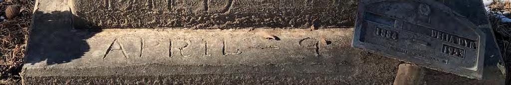
5 / Registration Form 8 St. Charles County, Missouri Photographs Submit clear and descriptive photographs. The size of each image must be 1600x1200 pixels (minimum), 3000x2000 preferred, at 300 ppi (pixels per inch) or larger. Key all photographs to the sketch map. Each photograph must be numbered and that number must correspond to the photograph number on the photo log. For simplicity, the name of the photographer, photo date, etc. may be listed once on the photograph log and doesn t need to be labeled on every photograph. Photo Log: : City or Vicinity: O Fallon County: St. Charles State: Missouri Photographer: Dorris Keeven-Franke Date Photographed: 1/18/18-1/26/18 Description of Photograph(s) and number, include description of view indicating direction of camera: 1 of 9: Facing west, this is the gravestone of Priscilla Ball which is the oldest extant stone in the cemetery. 2 of 9: Facing north, this is the old road bed still visible, with Veterans Memorial Parkway intersecting it. 3 of 9: View from the Northeast corner looking towards the Southwest corner showing subdivision and neighbor s fencing 4 of 9: View from the Southwest corner looking towards the Northeast corner 5 of 9: Facing west, this is the homemade concrete marker of Delliah Dier 6 of 9: Facing west, this is an example of one of the broken stones. 7 of 9: Facing west, this is the Howard Morris stone which recently replaced a severely broken stone for this WWI veteran on 8/12/17, which was done by the neighboring V.F.W. Post of 9: Facing south, this is the first sign placed approximate fourteen years ago 9 of 9: Facing south, this is a new sign made and placed by a Boy Scout Eagle Project in Figure Log: Include figures on continuation pages at the end of the nomination. Figure 1: Appendix A: List of the 117 people who research has identified as being buried in. The * symbol identifies those able to be located by an extant marker. Figure 2: Site Map Figure 3: Context Map, GoogleMaps, Latitude/longitude coordinates: , Figure 4: Plat Book of St. Charles County, Missouri (Des Moines, IA: Northwest Publishing Co., 1905) Figure 5: 1994 USGS map with location of indicated. Figure 6: Examples of pre-1968 extant grave markers Figure 7: The original gravestone for Howard I. Morris and the replacement stone, donated by the V.F.W. Post Figure 8: Examples of grave markers for burials added after 1968 Figure 9: Census data for St. Charles County and O Fallon, Figure 10: Excerpt from 1905 map of O Fallon showing the African American enclave along Sonderen. Figure 11: Excerpt from 1932 map of O Fallon showing the African American enclave along Sonderen. Figure 12: Preacher Jefferson Franklin Sage Figure 13: Extant African American School. Google Maps Street View from July 2017.
6 / Registration Form 8 St. Charles County, Missouri Figure 14: Willis Thornhill s former residence once associated with the local African American Odd Fellows Lodge, at 116 Sonderen Street. Google Maps Street View from July Figure 15: Faces of some of those buried in. Personal photographs with digital copies in Dorris Keeven-Franke s personal collection. Figure 16: Site Map for Photos
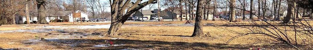
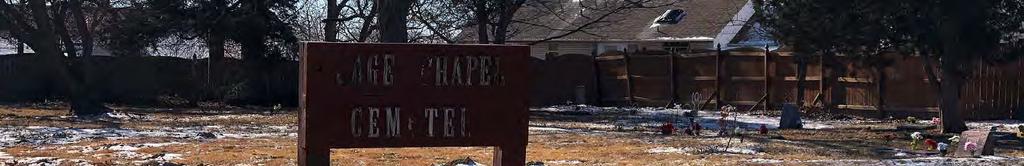
7 Section number 7 Page 1 St. Charles County, Missouri Summary is an African-American cemetery located on Veterans Memorial Parkway 0.3 miles east of Highway K in O Fallon, St. Charles County, Missouri. The cemetery does not have a designated postal address. This is the only African-American cemetery still in existence in the City of O Fallon; it most likely began as a burial ground for the former enslaved members of the Samuel Keithly household. It contains at least 117 burials (Figure 1) that have been documented by headstones, obituaries, death certificates and/or living family members. Of these at least 17 were born into slavery. It became a formal one-acre plot to be used as a cemetery when deeded to the Trustees of the African Methodist Episcopal (A.M.E.) Church in 1881; c.1881 therefore marks the start to the period of significance. However, it is likely this site was used as a burial ground for slaves prior to the land officially being deeded to the A.M.E. Church. 1 The period of significance ends in 1968, but the last internment was made in The earliest extant gravestone dates to 1900 (Photo 001). Area African-American families have used this cemetery for over 100 years. The church building that was originally associated with the cemetery was located ½ mile to the north, and despite exhaustive research, no records have ever been found that are associated with either that church congregation or this cemetery. The church building itself is no longer exists, and the congregation ceased meeting over seventy-five years ago. The cemetery is largely a grassy lot with 32 grave markers still visible (Figure 2); four of these markers are for two individuals. Three graves are marked by handmade family memorials which include garden ornaments and small statues that do not have a gravestone. Several mature trees dot the landscape, which is flat. Overall, the cemetery looks much as it did historically, though some of its grave markers have been lost to time. One marker has been replaced (as discussed below). 12 burials are known to have been added after 1968 as the cemetery continued to accept occasional burials. The area around the cemetery now houses modern residences, a Veterans of Foreign Wars Post, and some commercial development further west and across the street (Figures 2 and 3). A wooden privacy fence separates the cemetery from the neighboring yards on the south and west and a tree line associated with an old road bed marks the cemetery s eastern boundary. The northern boundary extends to the sidewalk running along Veterans Memorial Parkway. The cemetery grounds represent a single contiguous site of the same dimensions as it was historically. There have been very few alterations to the cemetery grounds. Two signs were added in recent years in order to make the public aware of its existence. These are the two noncontributing objects in the resource count. They sit facing north and are visible 1 The land deeded for the church that was originally associated with the cemetery was ½ mile distant from s location, suggesting that the land specifically deeded for use as a cemetery was already being utilized for this purpose at this time. Local oral histories also indicate that the site was used as a burial ground for slaves prior to the land officially being deeded in 1881.
8 Section number 7 Page 2 St. Charles County, Missouri from Veterans Memorial Parkway. The first is a small wooden sign made by localresidents fourteen years ago (Photo 008); its fading white letters read SAGE CHAPEL CEMETERY. The second sign is a recent Boy Scout Eagle project, completed in 2015 (Photo 009). This is a larger wooden sign that reads SAGE CHAPEL CEMETERY Est Setting This property originally belonged to the Samuel Keithly family who arrived in Missouri by 1817 (discussed further below). Throughout history has been near a roadway. Today, two lines of trees (Photo 002) demark an old wagon road that originally ran along the east side of the cemetery. They delineate the first documented roadway which appears on the 1905 plat map (Figure 4). The westernmost line of trees associated with this old roadway marks the east side of the cemetery which adjoins the property of the Veterans of Foreign Wars (V.F.W.) Post No There is a small expanse of grassy space on the other side of the roadbed before reaching the parking lot for the VFW Post. The VFW Post No purchased their property in The cemetery property is bounded, and fenced, on the south and west (Photo 003) by the Spring Hill Subdivision, which was platted in Subdivision property owners have erected the only known fences to have ever existed on the western and southern cemetery boundaries; some of these fences are partially on the cemetery s legal parcel, but are associated with the neighboring residences and so are not included in the resource count. In 1922, property to the north of the cemetery was deeded by Gerhard B. and Elizabeth Sonderen to the State of Missouri for a new highway, State Highway 2. 3 The highway later changed names to United States Highway 40 in Today, this road is called Veterans Memorial Parkway, a street which serves as a service road for Interstate 70 (Figures 3 and 5). Immediately across the Parkway from the cemetery and the VFW Post are residences and some commercial development (Photo 002, 004). Description The cemetery is a level piece of grassy ground (Photos 003 and 004) where there are at least 117 burials (Figure 1). The property is one acre, as it was originally deeded. Mature trees line the border of the cemetery and are interspersed throughout the landscape, although a few have been lost. There are cedar trees at three of the four corners (Figure 2). The middle of the cemetery remains only sparsely populated by markers (Photo 003), but several of the families describe vividly that they know there are graves interspersed throughout the cemetery and centrally located. Documentation 2 St. Charles County Plat Book 31, p. 196, Subdivision Plat 6 April 1993; St. Charles County Deed Book 737, p. 1270, 4 August 1976; VFW Hall Deed, Deed Book 792, p. 1375, 9 March St. Charles County Deed Book 154, p. 82, 10 November Big Trans-Continental Traffic Increase This Year is Predicted, Joplin (MO) Globe, 14 February 1926 (Newspaper.com)
9 Section number 7 Page 3 St. Charles County, Missouri of burials through death certificates, obituaries, and local oral tradition substantiates this. 5 There is no organization, such as straight rows, for the cemetery. Families have simply added individual members as close as possible to other family members as they have passed. Many families were unable to afford markers and are known to have used wooden markers or relied upon temporary funeral home markers which have been lost over time. Thirty-two extant gravestones in various states of disrepair mark some graves; this number includes those that were added after 1968 (discussed below). Four of these stones are for two individuals. The earliest extant stone dates to 1900 (Photo 001). Gravestones vary from rocks and homemade pieces of concrete with letters carved into them (Photo 005), to small plain granite markers. Many of the markers lack any stylistic detailing, but a good proportion do include common cemetery motifs such as flowers with leaves and Christian symbols such as crosses or praying hands (see Figure 6 for examples of extant stones dating prior to 1968). Crosses and flowers are the most common motifs seen on the extant stones. Some markers are currently broken (Photo 006), are flat on the ground, and many need some repair. There are also family memorials placed on three graves that do not have formal gravestones identifying who is buried in that specific location. These memorials include artificial flowers, garden stones or ornaments, small statues, and other simple, more temporary but maintained markers. Artificial flowers are in fact quite common and are present at most of the known gravesites. A new marker was donated in August of 2017 by s neighbor V.F.W. Post 5077 to replace the World War I marker of veteran Howard Morris (Photo 007) that had fallen and become severely deteriorated. The replacement stone is in keeping with the first marker s appearance (Figure 7). 12 burials have been added since These more recent burials have markers that are generally in keeping with the extant historical markers (see Figure 8; the first photograph represents a family memorial with a garden stone, flowers, and simple name marker as there is no gravestone in place). Beyond the death date, most of these later markers are indistinguishable from the earlier stones and memorials and include similar motifs including crosses and flowers with leaves. As noted above two signs (noncontributing objects) were added to the cemetery in recent years (Photos 008 and 009). It is unknown whether there would have ever been similar historic signage. The only intrusion to the cemetery grounds involves a small 5 Lucille Wiechens and Carrol Geerling, Cemeteries of St. Charles County, Missouri, Vol. V (Bridgeton, MO: Lineage Press, 1988), discussed on page 114.
10 Section number 7 Page 4 St. Charles County, Missouri portion of the privacy fencing associated with the residences that abut the cemetery to the west and south. A piece of the fencing cuts through a very small portion of the southwest corner of the cemetery. This likely occurred due to confusion over parcel lines and the lack of maintenance to the cemetery grounds occurring in the 1980s and 1990s which obscured parts of the cemetery. Regardless, no known burials are located in that far southwestern corner, and the fence only obscures a very small portion of the original cemetery grounds. The fencing now serves to protect and divide the cemetery from the backyards associated with the subdivision. The cemetery is now maintained by the park system of the City of O Fallon, and is serene, quiet and park like despite its now somewhat modernized location in the midst of a growing city. Integrity Today looks much like it has for well over 100 years and includes the historic acreage as deeded in Though 12 burials have been added after the 1968 end date to the period of significance, the markers for those burials are very similar to many of the extant earlier markers, and thus they do not impact the historic appearance of the cemetery. The families of those buried here maintained the cemetery up until the 1980s. Though no fencing remains that is associated with the cemetery, some do remember an iron fence that once ran along the front of the cemetery; it is unknown when this fencing might have been removed. 6 In the late 1980s the cemetery became neglected and neighbors were not even aware that there was a cemetery on the property. The cemetery received some backhoe damage in 2012 because of a landscaper coming through the cemetery to work on the backyard of one of the homes bordering the south side. The following year, the O Fallon Historic Preservation Commission visited Sage Chapel and placed flowers on marked and unmarked graves based on the research of area historian Mary Hogan-Smith. After that damage occurred in 2012, awareness of the cemetery and its condition increased. The cemetery was cleaned and the grass cutting began again and it has been steadily maintained to-date. Trees have occasionally been removed as needed. The setting has been somewhat impacted by modern development around the cemetery, most of which is residential. However, the cemetery maintains integrity, especially as it relates to its historic location and boundaries, feeling and association. Today it appears just like residents, many of whom are nearly 90 years of age, say it always has. It still sits unchanged and serene providing an enduring testimony to those buried here. 6 Mary Patrick Stephenson (resident of O Fallon born in 1928) in video interview with Dorris Keeven- Franke, April 2018.
11 Section number 8 Page 5 Summary is located on Veterans Memorial Parkway 0.3 miles east of Highway K in O Fallon, St. Charles County, Missouri. It is locally significant under Criterion A, Ethnic Heritage/Black. provided the African- American community of the City of O Fallon a dedicated location for burial for well over 120 years. Now maintained by the City of O Fallon, it provides not only a voice for the African-American community, but an opportunity for a greater discussion of local African-American history and heritage. According to the oral history of descendants, the cemetery may have begun as a burial ground for slaves owned by the Keithly family. Later, on the 20 th of August 1881, it was conveyed by deed from Jasper N. Castlio and his wife Mahalah (daughter of Samuel Keithly) to the Trustees of the African Methodist Episcopal (A.M.E.) Church: Walter Burl, Jack Patterson and Taylor Harris. 7 The period of significance begins in c.1881, when the land for the cemetery was officially deeded to the African American community, though burials likely occurred prior to this date. The period ends in 1968, the 50 year mark, as no more specific end date to the period of significance could be determined. The cemetery continued to occasionally be utilized by the local African American community until the final burial in There were only 12 burials between 1968 and The cemetery meets Criteria Consideration D due to its association with the local African American community. Further, as will be discussed below, little else remains of this community both in regard to physical and documentary resources. It is one of only three known remaining resources associated with the local African American community in O Fallon and it is the only extant resource that is still clearly associated with its original use. This cemetery serves as a visual reminder of a time of segregation and continues to educate the entire community. Many members of the community who are descendants of those buried there remain and take great pride in and appreciate the open dialogue it creates with its presence, feeling that it provides an opportunity for their voices to be heard. This nomination is being made on their behalf. Brief History of O Fallon, Missouri The first settlement in what would become St. Charles County was established by Frenchman Louis Blanchette in 1769, though Native American tribes had lived in the area for some time, and the French had been exploring the territory since the 1710s. 8 One of the first Americans to settle in the region was trailblazer Col. Daniel Boone and his family, who arrived in c Jacob Zumwalt and his family arrived c settling in what would become the city of O Fallon several decades later. 10 They constructed a log home (recently reconstructed) now known as Zumwalt s Fort: the Zumwalts allowed 7 St. Charles County Recorder of Deeds, Book 35 Page 16 8 History of St. Charles County, Missouri ( ), 88.; O Fallon Historical Society History, Accessed May 24, 2018, 9 History of St. Charles County, Missouri ( ), Ibid.
12 Section number 8 Page 6 local area families and their slaves who fled to the fort protection during the War of Settlement and growth of the area continued well into the 1800s due, in large part, to westward expansion. With the purchase of the Louisiana territory in 1803, a large number of new settlers began to arrive. 12 With the U.S. financial crisis in 1837, families moved west with their slaves to snap up inexpensive land. This influx of settlers arrived from not only the east coast and states like Virginia and Kentucky but Europe as well. In Europe, books such as Gottfried Duden s Report on a Journey to the Western States inspired Germans in particular, seeking political refuge and better opportunities for their families, to immigrate to the area. The first influx of German settlers arrived in 1833, many of whom settled in St. Charles County. 13 Thus St. Charles County, and ultimately the city of O Fallon, was established largely by American settlers, many of whom arrived from states where slavery was common practice and thus brought slaves with them, and German settlers, the majority of whom were abolitionists. 14 As the state developed, so did the coexistence of these two cultures, with several families intermarrying. This often created a cultural anomaly: German immigrants who were slave owners. By the 1850s the community was a mix of early American slave owners and German abolitionists who sometimes owned slaves themselves. O Fallon itself was founded by the Krekel family who were German immigrants. O Fallon s first land owner, Arnold Krekel, was an early immigrant who arrived in St. Charles County with his father and siblings in He did own a slave in 1860, though he was an abolitionist. 15 He served as a Provost Marshall for St. Charles County and as a Colonel in the Union Army during the Civil War. 16 He also served as the head of Missouri s Constitutional Convention and signed Missouri s Emancipation Proclamation of January 11, His younger brother Nicholas Krekel built the first residence and 11 Ibid. 12 History of St. Charles County, Missouri ( ); Lorenzo J. Greene, Gary R. Kremer, and Antonio F. Holland, Missouri s Black Heritage. Revised and updated by Gary R. Kremer and Antonio F. Holland (Columbia, MO: University of Missouri Press, 1993), History of St. Charles County, Missouri ( ), Ibid Abolitionist German families owning slaves was not necessarily uncommon: Most were of the belief, that until the practice of slavery was abolished, they could provide a much better living environment for the African-Americans than they would encounter in the south. ; Dorris Keeven-Franke, Arnold Krekel, St. Charles County History, February 26, 2018, accessed May 24, 2018, 16 Ibid. 17 Dorris Keeven-Franke, Missouri s Slaves Emancipated, St. Charles County History. January 11, Accessed May 24, 2018,
13 Section number 8 Page 7 served as the first retailer in 1856, and by 1857 served as U.S. Postmaster, and Station Master for what became the Wabash Railroad. 18 With the railroad s expansion in 1856 O Fallon saw growth, and the sale of Public Lots occurred on July 22, The town was not incorporated until 1912, when it had approximately 600 residents. 19 History of O Fallon s African American Community As touched on above, the first African Americans to arrive in Missouri (and St. Charles County) were typically slaves who moved with American settlers from slave states such as Virginia and Kentucky. Earlier arrivals of which there would only have been a few may have been black Africans who were enslaved by the French who first settled the area in the 1700s. 20 In 1803, the total population of what would become Missouri was 10,340, of which 1,320 (close to 13%) were slaves. 21 Many of the early American settlers of Missouri (and St. Charles County) brought not only their slaves with them but also their ideas about slavery. As early as 1804 Black or Slave Codes were enacted and based on those established in Virginia; this code made no distinction between slaves and other property. 22 The issue of slavery ultimately became a key issue for Missouri s statehood, with controversy focused on whether Missouri should be established as a free or slave state. 23 Missouri was finally able to gain admission to the Union in 1821 as a slave state with Maine joining as a free state. 24 At the state level, the new state legislature in the nearby town of Saint Charles passed a law prohibiting free blacks from entering or settling in the state in There was also legislation passed allowing citizens to arrest runaway slaves. 25 In 1837, The Missouri General Assembly in Jefferson City passed an act prohibiting abolitionist publications from being published or circulated in the State of Missouri. 26 However, as home to a 18 O Fallon Historical Society, History, Accessed May 24, 2018, 19 Ibid. 20 Greene, Kremer and Holland, Ibid, Ibid, Ibid, Ibid, Missouri Compromise, A+E Networks, 2009, accessed May 24, 2018, 25 Missouri s Early Slave Laws: A History in Documents, Missouri State Archives: Missouri Digital Heritage, accessed May 24, 2018, 26 Ibid.
14 Section number 8 Page 8 large German population, Missouri was also home to large number of abolitionists, and thus was a hotly contested state during the Civil War. Immigration from Ireland and northeastern states in the decade prior to the outbreak of the war also contributed to a population often split between Union loyalists and Southern sympathizers. 27 Missouri freed their slaves on January 11, 1865 and slaves were freed nationally with the ratification of the 13 th Amendment on December 6, However, in the decades to come freed African Americans began to see a loss of freedoms, rather than the gains they had hoped for, particularly in the former slave states. 29 Missouri s 1875 constitution, for example, allowed separate schools for black and white students and there were instances where desegregated schools were re-segregated. 30 Statistics show a drop in the African American population in St. Charles County after the Civil War. The population then began to rise and was higher than prior to the Civil War by 1880; this is likely due to the large number of freed African Americans that were arriving in St. Louis from other former slave states as they made their way to regions considered friendlier to African Americans, such as Kansas. 31 As individuals arriving in the region ran out of funds to continue traveling they may have ultimately settled in the area, including St. Charles County and O Fallon, which is approximately 35 miles from St. Louis. However, proportionally the local African American population continued to dwindle compared to pre-civil War numbers. In 1860, St. Charles County had a population of which a little over 15% was African American. By 1970, just over 1% of the population was African American. See Figure 9 for available census data for St. Charles County and O Fallon from 1860 to Despite these population changes, African American communities began to establish themselves throughout Missouri. After the Civil War, an African-American enclave, or community of freed blacks 33 developed along a north-south road at the eastern town limits of O Fallon, extending from the Wabash Railroad to the south (see Figure 10 which depicts a portion of this enclave in 1905 and Figure 11, showing the area in 27 Guide to American Civil War in Missouri: A Brief History, The State Historical Society of Missouri, adapted from Prologue to The Civil War s First Blood: Missouri, by James Denny and John Bradbury, published by Missouri Life Media. Accessed May 24, 2018, 28 Greene, Kremer and Holland, Ibid, Ibid, Ibid, The City of O Fallon has seen exponential growth since In 2010 the city of O Fallon had a total population of 79,329. Of this population approximately 10% were minorities, with an African American population of 3,164, or about 4%. U.S. Census Bureau, 2010 Census of Population and Housing, Summary Population and Housing Characteristics, CPH-1-27, Missouri U.S. Government Printing Office, (Washington D.C. 2012), Accessed April 27, 2018, 33 O Fallon Historical Society, History, Accessed May 24, 2018,
15 Section number 8 Page ). Later, it became Sonderen Street, so named for Gerhard B. Sonderen, who initially owned much of the property. There they had residences, an African-American school and three churches: Wishwell Baptist Church (also referred to as the African Baptist Church 34 ), Cravens Chapel 35 (the Methodist Episcopal Church, North) and the African Methodist Episcopal Church that was first associated with Sage Chapel Cemetery and referred to as Sage Chapel. All of these churches are visible in Figure 10. The school remains (discussed further below) but the churches and most of the residences have been lost. There was a colored Odd Fellows Lodge in Willis Thornhill s house, which is the only extant residence (also discussed further below). 36 The first of the three African-American churches to serve the community was located on property owned by German born Henry Ernst and had been sold or gifted out of his estate to African Americans John C. Edwards and William D. Williams. 37 In 1872, Edwards and Williams deeded a square sixty feet on all sides to Joshua Wayne, James Dyer, and Washington Gibson, trustees for the A.M.E. Church, North, which eventually acquired the name Cravens Chapel (not extant). 38 Cravens stood along Sonderen near the railroad tracks. This community along Sonderen continued to grow on property that oral tradition states was gifted to them by their former owners, but the community s status as an African American enclave was also documented by U.S. Censuses from 1870 to The 1920 Census taker Warren Barebo referred to the area running from the Wabash Railroad south to as Nigger Hill ; this is also noted on the 1930 federal census. 39 The land was part of the former plantation of Samuel Keithly. The distance from the railroad to is just one mile. In 1881 there was no official burying ground established for the African-American community in O Fallon. The closest known location with African-American burials at this time was the Catholic cemetery associated with St. Paul Catholic Church. That cemetery has both white and African-American burials. This church and associated cemetery are still extant (1223 Church Road, St. Paul) and still in use. St. Paul, Missouri is a community established by German immigrants in 1834 and adjoins O Fallon on the northwest side of O Fallon. The earliest African-American burial in St. Paul Catholic 34 Many of these churches had several names historically, often very similar to the names of other local African American churches. To avoid confusion they are referred to by their most identifiable name. 35 Some maps, including Figure 10, label Cravens as African Methodist Episcopal Church, North. This church is more accurately referred to as Northern Methodist. It was most commonly known as Cravens Chapel (O Fallon Centennial , page 23). 36 St. Charles County Recorder of Deeds, Book 105, page St. Charles County Deed Book 7, p. 154, 27 January St. Charles County Deed Book 28, p. 13, 16 April U.S. Federal Census, Missouri, St. Charles County, Dardenne Twshp, O Fallon City, Sheet 2 B, taken the 8 January 1920 by Warren Barebo; 1930 U.S. Federal Census, Missouri, St. Charles County Ward 1, O Fallon City, Sheet 2B taken the 3 April 1930 by Warren Barebo.
16 Section number 8 Page 10 Cemetery was Eleanora Hayden, who was buried there on April 1, These burials were segregated within the cemetery. St. Paul continued to receive African American burials well into the twentieth century. 41 The lack of a burying ground for all the members of the African-American community in O Fallon would be solved by the formation of the second church to serve the local African-American community: the A.M.E. Church that would become Sage Chapel. History of Slave owner Samuel Keithly/Keithley Sr. (it is spelled both ways in legal documents) was born March 31, 1789 in Green County, Kentucky and died October 12, 1870 in O Fallon, Missouri. 42 According to the 1850 U.S. Census Slave Schedule for St. Charles County, Keithly owned twelve slaves. 43 In 1860 Keithly owned 19 slaves. 44 Of the 117 documented burials in (Figure 1), at least 17 were born as slaves. Of the 32 extant stones, six are known to mark the graves of former slaves. At least four of these individuals were former slaves of Samuel Keithly. 45 Jasper Newton Castlio s wife Mahala Castlio inherited this land from her late father, Samuel Keithly. This included Lots 6, 7, and 8 of what is described as the Keithly partition of Ten years later, this couple decided to deed a portion of their property to the newly formed A. M. E. congregation that would become Sage Chapel. On August 20, 1881, the Castlios deeded a half-acre plot of ground out of Lot 6 of Keithly s partition and one acre out of Lot 8 of Keithly s partition to Walter Burrell, Jack Patterson, and Taylor Harris, as Trustees of the A.M.E. Church. The half-acre lot was deeded for the site of their church and the one-acre lot was deeded specifically for the site of the church s cemetery. 46 The church property was located on what is today Sonderen Street about half-way between the Railroad tracks and, or a distance of about ½ mile (see Figures 10 and 11, it is the African M.E. Church at the bottom of the cutout in Figure 10). The lands for the church and cemetery were placed under a deed of trust on December 1, 1881 by the church trustees. 47 By 1883, Patterson had left as a trustee of the A.M.E. Church in O Fallon, leaving only two trustees. Burrell and Harris deeded the east half of the church s half-acre lot to James Edwards in The 40 St. Paul Catholic Church Burial Index at the St. Charles County Historical Society; some of the later Hayden family members are buried at. 41 The latest identified is Mary Dryden, who died at the age of 103 on 19 July 1965 in St. Louis and was buried in St. Paul, MO: 42 Samuel Keithly, Find A Grave, Added July 18, Accessed May 9, 2018, U.S. Census Slave Schedules, District 78, St. Charles Co., MO, U.S. Census, Slave Schedules, District 78, St. Charles Co., MO, United States Census Slave Schedules, District 78, St. Charles Co., MO & 1860 United States Census Slave Schedules, District 78, St. Charles Co., MO, 46 Deed Book 35, p. 16, 20 August Deed Book 34, p. 164, 1 December 1881
17 Section number 8 Page 11 deed shows that a church building had been built by that time. 48 Although the cemetery was officially deeded and established in 1881, the earliest death date on an extant gravestone at is Earlier markers have been lost to time. At the same time as the Trustees acquired the property, the St. Charles African Methodist Episcopal Conference had a Pastor named Jefferson Franklin Sage who preached in this area (see Figure 12). 50 Sage, born a slave in Missouri in 1854, made his home in Jonesburg, Missouri, and ministered in the A.M.E. St. Charles Church Conference in He appears on the Missouri State Census in Jonesburg, Montgomery County for 1876, with his wife Eliza and their two small sons Dick and John. 51 From the A.M.E. Conference reports made by Brother Samuel Jenkins on November 28, 1878, we know that Sage is noted as a "Local Preacher Jefferson Sage of Jonesburg," indicating he is a member and a Minister of the St. Charles Conference. 52 By 1880, Preacher Sage moved to with his second wife, Mary. 53 Preacher Sage is then noted in the records of the A.M.E. St. Charles Church Conference as a traveling Pastor in 1886 and in His mission is along a route between the City of, and his former home of Jonesburg. This route coincides with today s Veterans Memorial Parkway. Research shows that Jefferson Franklin Sage had left the O Fallon area by 1894, because his daughter Ruth is born in Kansas in May of 1894, where he is an A.M.E Minister of the Gospel there. 55 However, his early association with O Fallon may be the reason this A.M.E. Church was referred to as Sage Chapel and the cemetery as. 56 African American Resources in O Fallon and the Surrounding Area 48 Deed Book 33, p. 460, 12 November Lucille Wiechens and Carrol Geerling, Cemeteries of St. Charles County, Missouri V (Bridgeton, MO: Lineage Press, 1988): Dorris Keeven-Franke, Preacher Jefferson Franklin Sage, St. Charles County History, October 16, 2017, accessed May 24, 2018, Missouri State Census, Montgomery County, Roll MOSC_ African-Methodist Church Book, Donated by Wardell Reed to the St. Charles County Historical Society, St. Charles County, MO. in These are Conference Records of the St. Charles African-Methodist Episcopal Churches in St. Charles County U.S. Federal Census, St. Charles County, Saint Charles, Enumeration District 201, Roll 714, Page 72A 54 African-Methodist Church Book U.S. Federal Census, Ottawa Kansas, Enumeration District 0086 Ward 2, Franklin Roll 480, Page 10A 56 In addition to the above citations, some of this information is also corroborated by Lloyd Monroe, descendent of Rev. Jefferson Franklin Sage.
18 Section number 8 Page 12 A third African-American congregation to form was Wishwell Baptist Church (not extant). It too acquired property that was formerly part of the Keithly partition for a church building. It was on Sonderen Street, equidistant between Cravens Church and Sage Chapel, and about ¾ of a mile from (it is labeled as the African Baptist Church in Figure 10). George and Martha Murray deeded land in the northwest corner of a one-acre lot to W. C. Long, George Washington, and Daniel Frost, Trustees of the African Baptist Church, in The Wishwell Baptist and Cravens Methodist churches jointly purchased a one-acre parcel of land for a burial ground in 1901 and named it Union Cemetery (not extant). Only 3 burials were able to be located there in All three seemed to have happened at Union Cemetery by There is no indication that the Union Cemetery was receiving any burials after 1929, and no trace of this cemetery remains today. We do know that both Cravens and Wishwell members were buried after 1909 in Sage Chapel Cemetery, making this a community cemetery, rather than one affiliated with a specific religious group or denomination. The Sage Chapel associated A.M.E. church operated from 1881 to c. 1932, Wishwell Baptist from 1899 to 1966, and Cravens Chapel from 1872 to c To date no records associated with these churches have been located and all three are no longer extant. There are no other African-American cemeteries located in O Fallon. Other than Sage Chapel Cemetery, only two extant resources in O Fallon are known to have been associated with the local African-American community historically. These resources are essentially all that remains of the enclave along Sonderen, an area that has largely been redeveloped. The school is still extant at 315 E. Elm Street. It has been altered over time with vinyl siding and changes allowing for its current function as a restaurant (see Figure 13). Across the street Willis Thornhill s house at 116 Sonderen Street, once utilized by the members of the African American Odd Fellows Lodge, still stands, though it too has seen some alterations including vinyl siding (Figure 14). Criterion A: Ethnic Heritage/Black & Criteria Consideration D: Cemeteries is significant under Criterion A, Ethnic Heritage/Black for its important association with the local African-American community. It meets Criteria Consideration D for Cemeteries. It is not only one of the few extant local resources associated with African-Americans, it is the only one that remains clearly tied to and still utilized by this community. Though there will be no future burials in the cemetery, it remains a place where local African Americans can go to remember and acknowledge their predecessors. 57 Deed Book 84, p. 56, 16 November Lucille Wiechens and Carrol Geerling, St. Charles County Cemetery Books Vol V, Union Cemetery discussed on page 107.
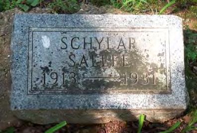
19 Section number 8 Page 13 As the African-American population of St. Charles County and O Fallon dwindled in the century after the Civil War, so did the resources associated with this community. This is especially true as the area has seen such dramatic population growth and therefore modernization and loss of historic resources in a short amount of time. Not only has remained largely unaltered, it retains the same acreage as originally deeded. Additionally, this cemetery reflects many decades of local African-American heritage. It includes burials of those who were born into slavery, those who were freed, those who were among the first generation of African-Americans who were born free, and those who faced and lived through decades of segregation and discrimination. Those buried here were of various religious denominations (Methodist, Baptist, and Catholic, see below) and from a variety of social classes (see the variation in gravestones). Those buried here include railroad workers, artists, carpenters, mechanics, pastors, laundresses, farmers, church trustees, and military veterans, to name only a few. The cemetery provides a crucial snapshot of O Fallon s African-American community from c.1881 to 1968 and beyond. Additional Discussion In 1929, Charles E. Sallee died in his home north of Wright City, Missouri on February 8 th or 9 th and was buried in the O Fallon Colored Church Cemetery : another name for. 59 When his daughter, Georgia Mae (death certificate) or Schylar (tombstone) Sallee, died two years later, the cemetery was called Osage Cemetery on her death certificate. 60 Both Charles and Schylar have tombstones at. Charles Sallee s widow, Ardalia, remarried to one Edward Welch. Her obituary states that she joined Wishwell Baptist Church in May 1898 under the pastorate of Rev. Long. 61 This would indicate that the family may have been affiliated with Wishwell. If so, this would also be an indication that, by 1929, Wishwell Baptist Church was no longer burying in Union Cemetery but also using Sage Chapel Cemetery. Members of Wishwell s congregation continued to utilize Sage Chapel Cemetery from this point on until its dissolution in The first mention of Sage Chapel Cemetery by that name appears on the 1954 death certificate for John Rafferty, 59 Warrenton (MO) Banner, 15 February 1929 (says he died 8 February); death certificate says he died 9 February and that he was buried in O Fallon Colored Church Cemetery, 60 Georgia Mae Schylar Sallee died 27 July 1931, 61 Obituary of Mrs. Ardalia Welch, Warrenton (MO) Banner, 4 February 1960 (Newspapers.com); her sister Cora married Simon Leslie White and is buried with him at 62 Deed Book 447, p. 532, 17 March 1966
20 Section number 8 Page 14 an unmarked burial. 63 Oral histories from his descendants relay that Rafferty was born a slave on the Keithly family estate (his property is noted on the 1932 map, Figure 11). His is also the first documented burial in from Cravens Methodist Church. 64 Over time, not only has the reason for the name Sage Chapel Cemetery become speculation, but other names have been attached to it through those who came to reside there. Oral history of African Americans in O Fallon state that it was named Sage Chapel because the blacks liked to worship in a field of Sage. 65 s association with the entire African-American community of O Fallon contributed to its being referred to by many names, including O Fallon Cemetery, O Fallon City Cemetery, Osage or Femme Osage Cemetery, Colored Church Cemetery, St. Shepherd Cemetery, Hayden Cemetery, and even Cravens Cemetery and Wishwell Cemetery. Those known to have been buried here may have their burial site listed as any of the above on their death certificate. However, the cemetery is most commonly known as, and it is the name preferred by the local community. There were a few burials in during the 1960s, but few illustrate the story of the African-American community and their relationship to the larger community of O Fallon better than that of Claude (on the tombstone) or Clyde (obituary) Dierker. 66 He is fondly remembered by his family and his community, and his story shares a description of an unusual burial in the. Born on July 5, 1922, to Edward and Bettie (Williams) Dierker, he was the fourth son of their ten children. The family lived near the intersection of Elm and Sonderen, next to the Cravens Methodist Episcopal Church (not extant) and O Fallon s small black one room schoolhouse (Figure 13). On Friday, October 27, 1967 forty-five-year-old Clyde s home was engulfed in a fire at just ten minutes past 9 p.m. He was home alone at the time, and even though O Fallon Fire chief Bill Steiner battled the blaze for several hours, the entire house was destroyed, and Clyde perished. It was difficult to keep the fire from spreading to the neighboring buildings. He left behind four brothers Louis, Frank, Bill and Julius Dierker and two sisters Arie Harvey and Mae White. Dierker s Funeral services were held by the Parish Priest Father Raymond Diermann at the nearby Assumption Parish where the family were members. At a meeting of the O Fallon Historic Preservation Commission, Commissioner Don Dietrich, who had served as a twelve-year-old altar boy for the funeral, recalled It was so emotional! Everyone was distraught as Clyde was well-loved and single. This was a rare event for 63 John Rafferty Jr. was born in 1860 and died 7 April 1954; John was born a Keithly slave, as was his father, John Rafferty Sr. who was born in 1835 and died c It is likely that his was the first burial in Sage Chapel Cemetery. 64 John Rafferty Funeral Held Sunday April 11, O Fallon Community News, 7 April Interviews with Phyllis Hayden, Betty White, Mary Stephenson 66 Obituary in O Fallon Community News, 1 November 1967
21 Section number 8 Page 15 Dietrich, too, who could not remember another traditional Catholic funeral held in Sage Chapel Cemetery. This was not a staid and solemn burial, but one complete with many emotional outbursts from the women attending that day. Claude and his cousins, the Williams, Lucketts, and Haydens, are only two generations removed from slavery. His neighbors in life were the Edwards, Claiborne and White families, who were also his relations (see Figures 10 and 11: the 1905 map of Sonderen includes properties owned by the Claiborne, White, and Edwards families, the 1932 map shows properties owned by the White, Williams, and Edwards families). All of these families have loved ones buried at. This was a close-knit community, where everyone was related somehow. It apparently did not matter which Church they attended, they were all joined by not only their color but by family relationship. Many of those who lived along Sonderen are buried in (see Figure 15 for a photograph of Simon and Cora White who lived along Sonderen and are buried in Sage Chapel Cemetery, along with photos of other members of this community buried here; Figure 11, the 1932 map of Sonderen, shows Simon White s property). We close the period of historical significance in 1968, but there have been a few modern developments since then. has received twelve burials from 1968 to The first cemetery sign was placed in in 2004 by the David Hinman and Louis Swinger families. The cemetery received a second sign from a Boy Scout project in May Both signs stand today. Members of the African-American community do not wish for the first one to be removed, and are extra fond of it. is a memorial to the O Fallon African-American community that still exists today. It became a final resting place for many with connections to that community. Those interred there died in O Fallon, St. Peters, St. Charles, Wright City, Kinloch, and St. Louis, Missouri, and in Vinton, Louisiana. It is the final resting place for at least two veterans, Howard I. Morris and Leo Larue Hart. When O Fallon resident Jim Frain first visited the in June 2013, he noticed that the headstone for Howard Morris, a World War I veteran, was broken and in danger of being lost. He approached his friend, Sheldon Hartsfield, also a veteran, and a member of the V.F.W. Post 5077, s neighbor to the east. Taking further action, Frain, and a few other members of the community came together, wanting to draw attention to the plight of the derelict cemetery. Since then, area historians have researched the cemetery s history and the City of O Fallon began to maintain the cemetery. They have not only cut the grass, but when large trees were toppled, they addressed the situation. The African-American 67 See for a video on the dedication of the cemetery sign.
22 Section number 8 Page 16 community took notice, and the City s Communications Department became involved and created videos in recognition of O Fallon s Black History Month. Flowers were donated, and members of the Historic Preservation Commission placed them on all the visible graves. Community involvement grew larger with other programs about the African-American Community, bringing Mayors and representatives from neighboring cities. Most recently, in August of 2017, the community s concern for this local landmark came together with a most moving tribute in realization of its importance. The family of Howard Morris, Ms. Phyllis Hayden, was presented a brand-new headstone for her uncle, with a full military funeral conducted by the V.F.W. Post One of the most beautiful ceremonies, attended by hundreds, this was a genuine demonstration of the love the O Fallon community has for this landmark and the people associated with it. 68 Conclusion is being nominated under Criterion A, Ethnic Heritage, for its association with the local African-American community. Its period of significance begins in c.1881, the year the site was officially deeded to the local African American community for use as a cemetery (though some burials likely occurred earlier) to Use of the cemetery continued beyond 1968 with the addition of 12 burials. The cemetery largely retains its historic appearance, including its original acreage, as deeded. This cemetery is significant to more than the African-American community of O Fallon. While this may be only a portion of the city s rich history, it is a very necessary part. It provides dialogue and an opportunity to reach out and seek greater understanding. It is significant in an educational role: as the stories of over one-hundred of our residents are shared, everyone will be able to learn. Furthermore, it is one of the few remaining resources associated with and the only one that remains intimately connected to this local African-American community. is already significant as a burying ground where people s lives should never be forgotten. But even more important is the role the cemetery continues to play in our community s history which also needs to be acknowledged, and the voices of these individuals heard. 68 See for photographs and a video of the ceremony held at for Howard Morris on August 12, This link includes other videos concerning and its history.
23 Section number 9 Page 17 Bibliography: 1895 Kansas State Census, Missouri State Census, Montgomery County, Roll MOSC_ , 1900, 1920, 1930, 1940 United States Census records, United States Census Slave Schedules, District 78, St. Charles Co., MO, United States Census Slave Schedules, District 78, St. Charles Co., MO, United States Federal Census, St. Charles County, Saint Charles, Enumeration District 201, Roll 714, Page 72A United States Federal Census, Ottawa Kansas, Enumeration District 0086 Ward 2, Franklin Roll 480, Page 10A United States Federal Census, Lexington, Ward 3, Lafayette County, Missouri Page 4A Enumeration District United States Federal Census, St. Charles County, Dardenne Twshp, O Fallon City, Missouri, Sheet 2 B, taken the 8 January 1920 by Warren Barebo United States Federal Census, St. Charles County Ward 1, O Fallon City, Missouri, Sheet 2B taken the 3 April 1930 by Warren Barebo. African-Methodist Church Book, Donated by Wardell Reed to the St. Charles County Historical Society, St. Charles County, MO. in These are Conference Records of the St. Charles African-Methodist Episcopal Churches in St. Charles County. American Press (Lake Charles, Louisiana), obituary of Leo Larue Hart, 19 March 2007, America s Obituaries and Death Notices, Newsbank, accessed via the St. Charles City-County Library District s Electronic Databases Baraba, Sarah, St. Charles County Historical Society Helps Man Uncover Family History, St. Louis Post-Dispatch, 15 February 2013 Baue Funeral Home records ( ), St. Charles County Historical Society Baue Funeral Home website, obituary of Delories Dee Thomas, Big Trans-Continental Traffic Increase This Year is Predicted, Joplin (MO) Globe, 14 February 1926 (Newspapers.com) Bruère, Theodore and W. W. Edwards, Illustrated Atlas of St. Charles County, Missouri (Illinois: W. R. Brink Co., 1875) Castlio, Mary Iantha, Some Missouri Pioneers: Their Ancestors, Descendants, and Kindred from Other States (Windsor, MO: Mary Iantha Castlio, 1923)
24 Section number 9 Page 18 Drummond, Malcolm C. Historic Sites In St. Charles County Missouri. St. Charles County Historical Society: Harland Bartholomew and Associates, Find A Grave. Samuel Keithly. Added July 18, Accessed May 9, Frain, Jim, Visited with Flowers from the O Fallon Historic Preservation Committee, 4 September 2013, O Fallon patch.com posting General Land Office Records, Bureau of Land Management, United States Department of Interior, Grant Chapel A.M.E. Church binder, St. Charles County Historical Society. Greene, Lorenzo J., Gary R. Kremer, and Antonio F. Holland. Missouri s Black Heritage. Revised & Updated by Gary R. Kremer and Antonio F. Holland. Columbia, MO: University of Missouri Press, Guide to American Civil War in Missouri: A Brief History. The State Historical Society of Missouri. Adapted from Prologue to The Civil War s First Blood: Missouri, by James Denny and John Bradbury, published by Missouri Life Media. Accessed May 24, Hayden, Phyllis. Interview with Dorris Keeven-Franke. February History of St. Charles County, Missouri ( ). First published in 1885, 2 nd printing 1969, 3 rd printing 1997 with introduction by Paul R. Hollrah. Howard Morris Cemetery. : O Fallon Missouri. August 24, Accessed May 24, Jost, Ashley, Genealogical Research Connects Descendants of Former Slaves in O Fallon, MO, St. Louis Post-Dispatch, 16/17 July 2017 Keeven-Franke, Dorris. Arnold Krekel. St. Charles County History. February 26, Accessed May 24, Keeven-Franke, Dorris. Missouri s Slaves Emancipated. St. Charles County History. January 11, Accessed May 24, Keeven-Franke, Dorris. Preacher Jefferson Franklin Sage. St. Charles County History. October 16, Accessed May 24, Missouri Compromise. A+E Networks Accessed May 24, Missouri s Early Slave Laws: A History in Documents. Missouri State Archives: Missouri Digital Heritage. Accessed May 24,
25 Section number 9 Page 19 Morris, Robert R., O Fallon, MO: A Good Place to Live (O Fallon, MO: Donning Company Publishers, 2006) Missouri State Archives, Missouri s Early Slave Laws: A History in Documents, O Fallon Community News obituaries, 1954 (John Rafferty at St. Charles County Historical Society); 28 February 1957; 6 October 1965; 17 August 1966; 1 November 1967 O Fallon Historical Society, History, Accessed May 24, 2018, Plat Book of St. Charles County, Missouri (Rockford, IL: W. W. Hixson & Co., 1930) Plat Book of St. Charles County, Missouri (Des Moines, IA: Northwest Publishing Co., 1905) Plat Map of St. Charles County, Missouri (Quincy, IL: Artcraft Co., 1948) topography map, Sanborn Map Company. O Fallon, Missouri, 1912 November. Digital Library, University of Missouri, Accessed April 27, 2018, Secretary of State of Missouri, Missouri Digital Heritage, Missouri Death Certificates, St. Charles Banner-News (daily) obituaries, 19 April 1972; 20 April 1972; 18 June 1976; 24 August 1976; 6 March 1978 St. Charles Cosmos-Monitor obituaries, 27 July 1904; 19 June 1907; 29 December 1909 (from 1909 binder that used to be at the St. Charles County Historical Society); 25 April 1917 (daily); 30 October 1935 (daily); 19 September 1957 (daily); 3 October 1957 (daily) St. Charles County Assessor, Property Search Database St. Charles County GIS map,, retrieved 27 December 2017 St. Charles County Recorder of Deeds, various deed records and Plat Book 31, p. 196 St. Charles Journal obituaries, 1 August 1963; 24 April 1972; 21 June 1976; 25 August 1976; 8 March 1978; 13 July 1988 St. Charles Post, 6 December 1982 and 9 February 1983 St. John s A.M.E. Church book (St. Charles A.M.E. circuit records), St. Charles County Historical Society St. Louis Post-Dispatch obituaries, 11 September 1936; 29 August 1940; 24 July 1963; 5 March 1978; 29 December 1981 (St. Charles Post); 11 July 1988 (St. Charles Post) St. Paul Catholic Church Burial Index at the St. Charles County Historical Society
26 Section number 9 Page 20 Stephenson, Mary Patrick. Resident of O Fallon, born in Video Interview with Dorris Keeven- Franke. April 4, Swinger, Pat, Sage Chapel, O Fallon Community News, 18 February 2004 United States Census Bureau, 2010 Census of Population and Housing, Summary Population and Housing Characteristics, CPH-1-27, Missouri U.S. Government Printing Office. Washington D.C Accessed May 24, United States Census Bureau. Census of Population and Housing Accessed April 27, United States City Directories , United States Social Security Applications & Claims Index, Warrenton Banner obituaries, 15 February 1929; 4 February 1960 Wentzville Union obituaries, 21 January 1916; 27 April 1917; 8 February 1918; 23 April 1920 (estate sale); Westhoff, Herbert and George Allred, O Fallon Centennial, (Warrenton, MO: Bilmac Press, 1956) White, Betty. Interview with Dorris Keeven-Franke. October 28, Wiechens, Lucille and Carrol Geerling, Cemeteries of St. Charles County, Missouri, Vol. V (Bridgeton, MO: Lineage Press, 1988).
27 Section number 10 Page 21 Verbal Boundary Description: is a 1.02 square acre bounded on the north by Veterans Memorial Parkway, on the east by the property of Post 5077 of the Veterans of the Foreign Wars, on the south and the west by the Spring Hill Subdivision. See Figure 2. Boundary Justification This is the same one acre tract of land deeded to the Trustees of the African Methodist Episcopal Church to be used as a cemetery in 1881.
28 Section number Figures Page 22 Figure 1. Appendix A: List of burials in as documented by grave markers, family members, death certificates and obituaries Abbington/Abington, Edward Hayner 23 Aug May Abbington, Liberty M. 21 Dec Jun Abernathy, Mable Tucker Edwards Claiborne 8 Jul Oct Abington, Eldora Welch 15 Jun Mar 1921* 5. Abington, Frank McKennie 3 Sep Oct Abington, Zone d. 24 Jul Ball, Thomas Hubert 14 Apr Feb Ball, Priscilla Admire May 1900* 9. Brady, Frank 2 Feb Mar Brady, Maria/Mary Carter Aug Mar 1924* 11. Brady, Myrtle Sep Jan Burrell, Martha J. Williams Apr Jan 1908* 13. Carter, Elvira Elizabeth Luckett 24 Dec 1885/ Sep Carter, Fred 21 Aug Nov Carter, William 17 Nov Oct Claiborne, Amos W. 23 Feb Aug Claiborne, Clarence 4 Mar Feb Claiborne, Hilda Abington 14 Oct Sep Claiborne, Lucy Whitehead Mar Mar Claiborne, Mary Smith Feb Mar Claiborne, Sparrel Mar Clarence, Jane E. Hayden 9 Sep Dec 1946* 23. Clarence, Thomas 1877/ Oct 1923* 24. Clarence, William Harrison 23 Dec Sep 1965* 25. Cooper, Infant d/o Albert & Nellie M. (Luckett) b/d 22 Apr Crowder, Albina 15 Oct Nov Crowder, Berniss 6 Feb Jun Crowder, Joe 20 Feb Mar Crowder, Lizzie age 10m 30 Mar Davis, Winston d. 19 May 1907* 31. Dierker, Alice 25 Aug Sep Dierker, Annie 24 Nov Apr 1917
29 Section number Figures Page Dierker, Claude/Clyde 5 Jul Oct 1967* 34. Dierker, Ed 7 Apr Apr Dryden, Frances Rafferty Letcher 15 Aug Mar Dyer, Delia D. Nash 1 Jan 1884/ Apr 1953* 37. Edwards, Alvin/Treny/Trevy Nov Jun Edwards/Vardeman, Arthur M. 28 Aug Jun Edwards, Dorothy Patrick Smith Hart Turner 28 Feb Feb 1952* 40. Edwards, Ernest 5 Nov Mar Edwards, Fred 9 Mar Mar Edwards, Georgia Clark Benton Mar Feb Edwards, John 10 Jun Dec Edwards, Marshal 3 Feb Jun 1902* 45. Edwards, Mary J. Stone 18 Jun Nov 1921* 46. Edwards, Artie Mishey Letcher Vardeman Hubbard 10 Nov Sep 1957* 47. Edwards, Roman V. 2 Aug Oct 1898* 48. Edwards, Virginia Hayden c Jul Edwards, Wesley 12 Mar May Hubbard, Gilbert 7 Jul Apr Hughes, Infant d/o Georgie b/d 9 Mar Luckett, Albert J. 18 Apr Aug Luckett, John Leslie 27 Jun Jan Luckett, Margaret Lee Hughes 8 May May 1953* 55. Luckett, Nellie Rafferty 27 Feb Jan Morgan, Ester Maria 27 Dec Mar Morris, Howard I. 8 Oct 1889/ Apr 1957* 58. Morris, Mary Truelove Luckett Vardeman 22 Mar Jan O'Day, Albert 7 Feb 1896/1894/ Aug O'Day/Otey, Ed 7 Jul Mar O'Day, Edith 1 Jun Apr O'Day, Jim 23 Sep Feb Owens, George Lewis Jul Rafferty, Alena B. Burrell Oct Jul Rafferty, John, Jr. 12 Aug Apr Robinson, Coattie/Cody Cleveland 24 Nov Sep Robinson, Erma 27 Apr Sep Sallee, Charles Edward 2 Apr 1876/3 Apr Feb 1929* 69. Sallee, David Grant 4 Jul Jul 1910
30 Section number Figures Page Sallee, Mary Elizabeth 4 Jun May 1919* 71. Sallee, Skylar/Georgia Mae 24 Jun Jul 1931* 72. Sanders, Adell 1 Aug Feb Sanders, Agnes 24 Dec Jan Sanders, Carl Rodger 2 Feb Apr 1937* 75. Sanders, George 30 Mar May 1940* 76. Sanders, Mary J. 3 Aug Nov Sanders, Mary Ellen Thomas Mar Dec Sanders, Taylor M. 1 Apr Feb Stewart, Granville 1 Oct Feb Stewart, Raymond 4 Jun Jan Taylor, Marie 28 Dec Jul Taylor, Smith d. 28 Dec Thomas, Andrew Okay Jun Feb Thomas, Dorothy May 15 Oct Feb Thomas, Eugene E. "Slick" 15 Feb Jul Thomas, George 17 Oct Jul Thomas, Henry C. 21 Aug Oct Thomas, Infant d/o Nathaniel & Lovetta (Hayden) b/d 25 Jul Thomas, John E. 22 Dec Oct Thomas, Nathaniel George 8 Jul Mar Thomas, Sedalia "Selley" Letcher Jun Jul Tucker, Henry Dec Tucker, Mary Feb Tyler, Elenora Stewart Jul Apr Vardeman, Florence Beatrice 7/8 Aug Feb 1911* 96. Vardeman, John W. 1 Mar Jan Vordiman, Rolf Chester 5 May Jun Washington, Lottie M. Thomas O'Day 5 Jun 1900/11 Jun Jun 1961* 99. White, Frona May 4 Feb Mar White, Jessie L. 4 Nov 1908/ Nov 1927* 101. White, Lucy Singleton Hughes St. Clair 16 Feb /23 Jan 1958* 102. White, Rufus Mar Feb White, Simon Leslie 7 Aug Aug 1966* 104. Williams, Infant s/o Frank & Stella Marie (Luckett) b/d 26 Oct Wyatt, Elizabeth Claiborne Mar Apr 1919
31 Section number Figures Page Furlow, Lovetta/Vetta/Velta/Veltha Hayden Thomas 13 Jan 1906 Jan Hart, Leo Larue (AKA Leon Baskerville) 25 Jun Mar 2007* 108. Hayden, Catherine Marie Williams 16 Oct Jul Hayden, Elizabeth Ashley 5 Aug Mar 1978* 110. Luckett, Leslie/Lester H. 12 Apr Apr 1972* 111. Norris, Betty Mae Elizabeth Hart Shorty 4 Mar Dec 1981* 112. Riley, Douglas Dean 5 Jan Apr Thomas, Delories Ruth "Dee Dee" Locke Bergesch 27 Aug Nov Thornton, Cora LuLurean White/LuLurean Cora 20 Apr Dec 1986/1990* 115. Vardeman, John Bearl 11 Nov Jun Vardeman, Mary Elizabeth Mozee 27 Sep Aug White, Cora E. Abington 10 Sep Nov 1972* * denotes those with extant markers

32 Section number Figures Page 26 Figure 2. Site Map, created utilizing GoogleMaps, Latitude/longitude coordinates are centered within the below boundary: , The two red rectangles indicate the location of the two noncontributing signs.

33 Section number Figures Page 27 Figure 3. Context Map, GoogleMaps, Latitude/longitude coordinates: ,

34 Section number Figures Page 28 Figure 4: Plat Book of St. Charles County, Missouri (Des Moines, IA: Northwest Publishing Co., 1905)

35 Section number Figures Page 29 Figure 5. O Fallon 1994 USGS map with location of indicated. Available online via the Internet Archive, direct download link:


36 Section number Figures Page 30 Figure 6. Examples of pre-1968 extant grave markers. Photographed by Justin Watkins and Dorris Keeven-Franke.


37 Section number Figures Page 31 Figure 7. The original gravestone for Howard I. Morris and the replacement stone, donated by the V.F.W. Post Photographed by Justin Watkins and Dorris Keeven- Franke.


38 Section number Figures Page 32 Figure 8. Examples of grave markers for burials added after The first photograph represents a family memorial with a garden stone, flowers, and simple name marker as there is no gravestone in place. Photographed by Justin Watkins and Dorris Keeven- Franke.
39 Section number Figures Page 33 Figure 9. Census data for St. Charles County and O Fallon, Pulled from Census of Population and Housing, U.S. Census Bureau, Accessed April 27, Census St. Charles County O Fallon Year White Black Total White Black Total ,313 2,210 16, ,381 1,922 21, ,652 2,411 23, ,656 2,315 22, ,332 2,139 24, ,974 1,718 24, * ,578 1,249 22, ,290 1,063 24, ,542 1,019 25, , , , ** 52,970 3, , ,546 1,155 92,954 6, ,018 *According to a November 1912, Sanborn Map, O Fallon s population in 1912 was 600. Source: O Fallon, Missouri, 1912 November, Sanborn Map Company, Digital Library, University of Missouri, Accessed April 27, 2018, **Some census data, depending on the year, reports minorities as Nonwhites, thus it does not differentiate between African Americans and other races. However, in those years where they were differentiated, the numbers of other races were very low; thus most of the population within St. Charles County historically was made up primarily of those identifying as White sometimes foreign born, which is not differentiated here and African Americans. For example, in 1970 O Fallon, 6,994 individuals were classified as White, and 15 were classified as Negro. Thus there were only 9 counted as another race (for that census year: Indian, Japanese, Chinese, Filipino, and All other ). In 1920, St. Charles County, only one individual was counted as another race.
40 Section number Figures Page 34 Figure 10. Excerpt from 1905 map of O Fallon showing the African American enclave along Sonderen. Source: Malcolm C. Drummond, Historic Sites In St. Charles County Missouri (Harland Bartholomew & Associates, 1976) Location of the African American school (Extant, see Figure 11). Of these African American resources, only the school and W. T. Thornhill s residence remain.

41 Section number Figures Page 35 Figure 11. Excerpt from 1932 map of O Fallon showing the African American enclave along Sonderen.

42 Section number Figures Page 36 Figure 12. Preacher Jefferson Franklin Sage. Source: Keeven-Franke, Dorris. Preacher Jefferson Franklin Sage. St. Charles County History. October 16, Accessed May 24,

43 Section number Figures Page 37 Figure 13: Extant African American School at 315 E. Elm Street, now utilized as a restaurant. Google Maps Street View from July Accessed May 7, 2018.

44 Section number Figures Page 38 Figure 14: Willis Thornhill s former residence at 116 Sonderen Street, once associated with the local African American Odd Fellows Lodge. Google Maps Street View from July Accessed May 7, 2018.


 Frances")
45 Section number Figures Page 39 Figure 15: Faces of some of those buried in. Personal photographs; digital copies in Dorris Keeven-Franke s personal collection. 1) Simon and Cora White, with Arlene, Betty, and Michael they lived on Sonderen Avenue 2) Dorothy Edwards 3) Frances Rafferty Dryden 4) Frank Brady 5) Nellie Luckett

46 Section number Figures Page 40 Figure 16: Site Map for Photos, Source: GoogleMaps, 2018


47


48


49


50


51


52


53


54


55
ALABAMA REGISTER OF LANDMARKS & HERITAGE NOMINATION FORM. Historic Name: and/or Common Name:
 ALABAMA REGISTER OF LANDMARKS & HERITAGE NOMINATION FORM 1. NAME OF PROPERTY Historic Name: and/or Common Name: Preferred name for Certificate: Historic Name or Common Name 2. LOCATION Street & Number:
ADDENDUM. Chain of Title. Tax Map 144, Parcel A
 Chain of Title Tax Map 144, Parcel A HB 1:618 April 18, 1868 JB10:323 March 12, 1900 NLP 7684:913 June 12, 1990 VJ 14547:444 February 26, 2001 Jane P. Williams to Trustees of the African Methodist Episcopal
Old Sandy Baptist Church Graveyard
 Old Sandy Baptist Church Graveyard By Dave Hallemann This original church cemetery is located in T41 R4 Survey 2018 in what was at one time called the Upper Sandy Settlement off Highway 21. It was visited
other names/site number Burlington Implement Company, Downtown Survey Map # J-162
 Site Inventory Form State Inventory No. 29-01140 New Supplemental State Historical Society of Iowa Part of a district with known boundaries (enter inventory no.) 29-03685, 29-00001 (November 2005) Relationship:
City of Jacksonville Landmark, Landmark Site, or Historic District Nomination Form
 City of Jacksonville Landmark, Landmark Site, or Historic District Nomination Form Grayed Areas for Use by Staff 1. Name of Property historic name Second Missionary Baptist Church Designation Number LM-14-2
HISTORIC SITE FORM - HISTORIC SITES INVENTORY PARK CITY MUNICIPAL CORPORATION (10-08)
") 1 IDENTIFICATION HISTORIC SITE FORM - HISTORIC SITES INVENTORY PARK CITY MUNICIPAL CORPORATION (10-08) Name of Property: St. John's Swedish Lutheran Church Address: 323 Park Ave AKA: City, County: Park
1 IDENTIFICATION HISTORIC SITE FORM - HISTORIC SITES INVENTORY PARK CITY MUNICIPAL CORPORATION (10-08) Name of Property: St. John's Swedish Lutheran Church Address: 323 Park Ave AKA: City, County: Park
Bible Christian Cemetery
 RESEARCH REPORT HTG-14-121 Bible Christian Cemetery 39 Columbus Road West Oshawa, Ontario Prepared for Heritage Oshawa Prepared by M. Cole August 2012 31 1.0 Introduction 1.1 Purpose of Report 3 1.2 Legislative
From the Archives: UTAH STATE HISTORICAL SOCIETY 300 Rio Grande Salt Lake City, UT (801)
") From the Archives: Sources 145 From the Archives: Sources UTAH STATE HISTORICAL SOCIETY 300 Rio Grande Salt Lake City, UT 84101-1182 (801) 533-3535 HOURS OF OPERATION 10 a.m.-5 p.m., Monday through Friday
From the Archives: Sources 145 From the Archives: Sources UTAH STATE HISTORICAL SOCIETY 300 Rio Grande Salt Lake City, UT 84101-1182 (801) 533-3535 HOURS OF OPERATION 10 a.m.-5 p.m., Monday through Friday
OCCGS Civil War Veterans Project. Veteran's Information
 OCCGS Civil War Veterans Project Veteran's Information Veteran's Name: Henry John DIERKER Birth Date: 5 April 1840 Location: Germany Death Date: 6 December 1928 Location: Orange County, California Buried
National Register of Historic Places Registration Form
 NPS Form 10-900 OMB No. 1024-0018 (Expires 5/31/2012) United States Department of the Interior National Register Listed National Park Service October 9, 2012 National Register of Historic Places Registration
Town Northborough. Name Brigham Street Burial Ground. Condition Fair. Acreage 3.29 acres
 FORM E BURIAL GROUND Assessor s Number USGS Quad Area(s) Form Number MASSACHUSETTS HISTORICAL COMMISSION MASSACHUSETTS ARCHIVES BUILDING 220 MORRISSEY BOULEVARD BOSTON, MASSACHUSETTS 02125 Photograph Town
(Enter "N/A" if property is not part of a multiple property listing
 United States Department of the Interior National Park Service National Register of Historic Places Registration Form This form is for use in nominating or requesting determinations for individual properties
Missouri. Copyright 2010 LessonSnips
 Missouri Missouri is located in the Midwest, surrounded by the states of Iowa to the north; Nebraska, Kansas and Oklahoma to the west; Arkansas to the south; and Illinois and Kentucky to the east. The
JOSEPH WIKERSON, SCIPIO, AND HC. I don t know what HC stands for! In all my searching, all these years, I have
 JOSEPH WIKERSON, SCIPIO, AND HC I don t know what HC stands for! In all my searching, all these years, I have found no document or evidence to suggest what these initials mean. I start with this point
Glade District, Oglethorpe County, Georgia Location: end of Pea Ridge Road, N W
 Glade District, Oglethorpe County, Georgia Location: end of Pea Ridge Road, N 34 00 05 W 83 02 40 Research and narrative by descendants: Mr. Glenn M. Paul and Dr. Michael M. Black Buried in this cemetery
Descendants of John Miller
 FIRST DRAFT OF 06/12/2003 Summary not to be relied upon as "primary documentation" SUMMARY OF ABSTRACT OF TITLE Utica Township, Clark Co., Indiana Tract 1 57 acres in Section 51 Tract 2-6.5 acres in Section
Our Community Service. by William A. "Steve" Stephens. [Portions Taken from my report to the members of the Moffat Cemetery Assn.]
![Our Community Service. by William A. Steve Stephens. [Portions Taken from my report to the members of the Moffat Cemetery Assn.]](/thumbs/95/125400252.jpg "Our Community Service. by William A. Steve Stephens. [Portions Taken from my report to the members of the Moffat Cemetery Assn.]") Our Community Service by William A. "Steve" Stephens [Portions Taken from my report to the members of the Moffat Cemetery Assn.] We begin with some background. We became involved in the cemetery shortly
Our Community Service by William A. "Steve" Stephens [Portions Taken from my report to the members of the Moffat Cemetery Assn.] We begin with some background. We became involved in the cemetery shortly
SAVANNAH - CHATHAM COUNTY HISTORIC SITE AND MONUMENT COMMISSION REGULAR MEETING 112 EAST STATE STREET ARTHUR A. MENDONSA HEARING ROOM MINUTES
 SAVANNAH - CHATHAM COUNTY HISTORIC SITE AND MONUMENT COMMISSION REGULAR MEETING 112 EAST STATE STREET ARTHUR A. MENDONSA HEARING ROOM November 1, 2007 4:00 P.M. MINUTES HSMC Members Present: HSMC Members
HISTORIC SITE FORM - HISTORIC SITES INVENTORY PARK CITY MUNICIPAL CORPORATION (10-08)
") 1 IDENTIFICATION HISTORIC SITE FORM - HISTORIC SITES INVENTORY PARK CITY MUNICIPAL CORPORATION (10-08) Name of Property: St. Mary of the Assumption Catholic Church & School Address: 121 PARK AVE AKA: City,
1 IDENTIFICATION HISTORIC SITE FORM - HISTORIC SITES INVENTORY PARK CITY MUNICIPAL CORPORATION (10-08) Name of Property: St. Mary of the Assumption Catholic Church & School Address: 121 PARK AVE AKA: City,
IN THIS ISSUE: FROM THE ADMINISTRATOR. From the Administrator...1. Questions...2
 IN THIS ISSUE: From the Administrator...1 Questions...2 News.. 3 Harriet Owen Lineage.....3 Varner/Riggs Update... 6 2014 Reunion..6 George Varner Line DNA... 6 FROM THE ADMINISTRATOR Family reunion is
Hallowed Grounds: Sites of African-American Memories. Courtesy of the archival collection at the Albany County Hall of Records
 Hallowed Grounds: Sites of African-American Memories Courtesy of the archival collection at the Albany County Hall of Records The history of African-Americans in the United States can be remembered not
BEFORE THE HEARING EXAMINER FOR THURSTON COUNTY
 COUNTY COMMISSIONERS Cathy Wolfe District One Diane Oberquell District Two Robert N. Macleod District Three Creating Solutions for Our Future HEARING EXAMINER BEFORE THE HEARING EXAMINER FOR THURSTON COUNTY
Shiloh-McCutcheon Cemetery. Shiloh-McCutcheon Cemetery is located southeast of the Williamson County
 Shiloh-McCutcheon Cemetery I CONTEXT Shiloh-McCutcheon Cemetery is located southeast of the Williamson County Courthouse in Georgetown near the town of Hutto, Texas on 163 off State FM 1660. The cemetery
 Criteria for Designation Saint James African Methodist Episcopal (AME) Church meets criterion 1 as a landmark under section 599.210 of the Heritage Preservation Regulations. Further investigation may demonstrate
HISTORIC PRESERVATION ELEMENT
 CHAPTER 17 HISTORIC PRESERVATION ELEMENT Page 1 of 10 CHAPTER 17 HISTORICAL PRESERVATION ELEMENT A. OVERVIEW In an effort to enrich the quality of life for Volusia s citizens, the goals, objectives, and
 St Paul German Evangelical Lutheran Church St Paul Evangelical and Reformed Church St Paul United Church of Christ Pilot Grove Community Protestant Church 12344 Highway N Pilot Grove, Missouri 65276 Phone:
The New York Public Library Schomburg Center for Research in Black Culture, Manuscripts, Archives and Rare Books Division
 The New York Public Library Schomburg Center for Research in Black Culture, Manuscripts, Archives and Rare Books Division Guide to the Asbury United Methodist Church (Washington, D.C.) records 1836-1986
D not for publication D vicinity. 1-z Date. National Register of Historic Places Registration Form _,.
 _,. NPS Form 10-900 (Oct. 1.990) OMB No. 10024-0018 United States Department of the Interior National Park Service National Register of Historic Places Registration Form This form is for use in nominating
An Overview of U.S. Westward Expansion
 An Overview of U.S. Westward Expansion By History.com on 04.28.17 Word Count 1,231 Level MAX The first Fort Laramie as it looked before 1840. A painting from memory by Alfred Jacob Miller in 1858-60. Fort
National Register of Historic Places Registration Form
 United States Department of the Interior National Park Service National Register of Historic Places Registration Form This form is for use in nominating or requesting determinations for individual properties
HISTORY OF THE UNIQUE BURIAL SITE OF JOHN AND NANCY OSTEEN MOORE. by Jesse Felma Moore
 HISTORY OF THE UNIQUE BURIAL SITE OF JOHN AND NANCY OSTEEN MOORE by Jesse Felma Moore 2017 Photo This year, 2017, marks the 150 th anniversary of the death of John Moore (1790-1867), son of Caleb. In this
ORDINANCE NO , and of Chapter 51 of the Dallas City
 ORDINANCE NO. 16439 12/11/79 An Ordinance amending CHAPTER 51, "COMPREHENSIVE GENERAL ZONING ORDINANCE," of the Dallas City Code, as amended, by permitting the following described property, to-wit: Being
Missouri State Archives Finding Aid 3.15
 Missouri State Archives Finding Aid 3.15 OFFICE OF GOVERNOR CLAIBORNE FOX JACKSON, 1861 Abstract: Records (1861) of Governor Claiborne Fox Jackson (1806-1862) consists of four items of correspondence.
1324 Gholson Road Clarksville, Tennessee (Approved February 10, 2013)
") 1 Cemetery Guidelines 1324 Gholson Road Clarksville, Tennessee 37043 (Approved February 10, 2013) 2 Bethlehem United Methodist Church Cemetery Policies and Guidelines All cemetery property is considered
1 Cemetery Guidelines 1324 Gholson Road Clarksville, Tennessee 37043 (Approved February 10, 2013) 2 Bethlehem United Methodist Church Cemetery Policies and Guidelines All cemetery property is considered
National Register of Historic Places Registration Form
 United States Department of the Interior National Register Listed National Park Service May 30, 2012 National Register of Historic Places Registration Form This form is for use in nominating or requesting
Hardin Cemetery No. 1
 Hardin Cemetery No. 1 GPS Coordinates: 35 12.43 92 16.20 Township 7 North, Range 12 West, Section 27 Political Township: Enola Location and Description Located in the northeastern section of Faulkner County,
Christian Street Rural Historic District
 Christian Street Rural Historic District Historic Tour No.6 in the Town of Hartford, Vermont Agricultural open space defines the Christian Street Rural Historic District, a 198-acre hamlet in the northeast
Tarrant County. Civil War Veterans of Northeast Tarrant County. Edward Pompi Deason. Compiled by Michael Patterson
 Tarrant County TXGenWeb Barbara Knox and Rob Yoder, County Coordinators Copyright 2010-2012. All rights reserved. Civil War Veterans of Northeast Tarrant County Edward Pompi Deason Compiled by Michael
Bradley Rymph IN THE FOOTSTEPS OF OUR ANCESTORS
 IN THE FOOTSTEPS OF OUR ANCESTORS RESTLESS PIONEERS Samuel Wilson King (1827 1905) & Margaret Taylor Gerrard (1831 1892) / Albert James Rymph (1851 1926) & Luella Maria King (1861 1949) Bradley Rymph The
It became a challenge to find Fleet Magee!
 While visiting Mississippi in November, Reggie, Terry, Barbara, and I explored several cemeteries where we had direct relatives interred. In the area we were visiting, pretty much every cemetery contains
Dorcas, a Free Person of Color in Washington County *Note The spelling was not changed from the original records.
 Dorcas, a Free Person of Color in Washington County *Note The spelling was not changed from the original records. Christopher Taylor was one of the early settlers of Washington County, Tennessee. He was
R E S O L U T I O N. B. Development Data Summary:
 R E S O L U T I O N WHEREAS, the Prince George s County Planning Board has reviewed Certification of Nonconforming Use Application No. CNU-45423-2016 requesting certification of a nonconforming use for
The Allegheny City Society REPORTER DISPATCH
 The Allegheny City Society REPORTER DISPATCH Spring, 2008 The Journal of Old Allegheny History and Lore Acorn Hill and Thomas M. Marshall by David R. Grinnell Evidence of the past is all around us. Often
CHURCHYARD RE-ORDERING
 CHURCHYARD RE-ORDERING Chancellor s Guidelines Guidance on alterations, move of memorials, landscaping and levelling of churchyards Diocesan Advisory Committee for the Care of Churches The management
Planning and Zoning Staff Report Corp. of Presiding Bishop LDS Church - PH
 Planning and Zoning Staff Report Corp. of Presiding Bishop LDS Church - Hearing Date: February 1, 2018 Development Services Department Applicant/Property Owner: Corp of the Presiding Bishop LDS Church
1. Name of Property Belmont Methodist-EpiscopalChurch other nameslsite number Metropolitan Community Church of the Blue Ridge; DHR File No.
 NPS Form 10-900 OM8 No, 1024-0018 (Expires 5/31/2012) United States Department of the Interior National Park Service National Register of Historic Places Registration Form This form is for use in nominating
MINUTES OF A REGULAR MEETING OF THE VILLAGE OF NEW LENOX PLAN COMMISSION. Held in the New Lenox Village Hall, 1 Veterans Parkway
 CALL TO ORDER MINUTES OF A REGULAR MEETING OF THE VILLAGE OF NEW LENOX PLAN COMMISSION Held in the New Lenox Village Hall, 1 Veterans Parkway Tuesday, June 16, 2015 7:00 p.m. #15 6 B A regular meeting
Historian ISDUP LIBRARY REMINDERS
 10 Daughters of the Future Keepers of the Past Historian Objective: Perpetuate the names and achievements of the men, women, and children who were the pioneers in founding this commonwealth, by preserving
ORDINANCE NO
 ORDINANCE NO. 2012-10 AN ORDINANCE REVISING AND CLARIFYING THE ARCHITECTURAL STANDARDS FOR RETAIL/OFFICE/FLEX AND MIXED USES IN THE JUNCTION AT MIDVALE OVERLAY (SECTION 17-7-9.12.2); ALSO PROVIDING A SAVING
Boise City Planning & Zoning Commission Minutes August 4, 2014 Page 1
 Page 1 CVA14-00030 / SCOTT STEWART Location: 1493 W. Saint Patrick Street VARIANCE TO REDUCE THE STREET-SIDE SETBACK FROM 20 FEET TO APPROXIMATELY 2 FEET AND REDUCE THE REAR YARD SETBACK TO APPROXIMATELY
HENRY¹ OF HINGHAM Sixth Generation
 HENRY¹ OF HINGHAM Sixth Generation No. 417 NAME: Stout⁶ Chamberlin Father: Richard⁵ Chamberlin (No. 218) [John⁴ (Henry³, John², Henry¹) and Rebecca (Morris) Chamberlin] Mother: Mary Stout Born: 1 May 1757,
Harrison House Collection, 1841-ca (bulk )
") Harrison House Collection, 1841-ca. 2000 (bulk 1841-1864) Collection Summary Creator: Moore, Eula C., collector Title: Harrison House Collection Inclusive Dates: 1841-ca. 2000 (bulk 1841-1864) Summary/Abstract:
Harrison House Collection, 1841-ca. 2000 (bulk 1841-1864) Collection Summary Creator: Moore, Eula C., collector Title: Harrison House Collection Inclusive Dates: 1841-ca. 2000 (bulk 1841-1864) Summary/Abstract:
Christians Say They Do Best At Relationships, Worst In Bible Knowledge
 June 14, 2005 Christians Say They Do Best At Relationships, Worst In Bible Knowledge (Ventura, CA) - Nine out of ten adults contend that their faith is very important in their life, and three out of every
 Pleasant Hill Baptist Church Cemetery Inquire and please, ask permission to enter private property. Quadrant Map: Billingsville General Location: East northeast of Pilot Grove Congressional Township: Township
CEMETERY RULES AND REGULATIONS
 Preamble. To be absent from the body, and to be present with the Lord. 2 Corinthians 5:8 CEMETERY RULES AND REGULATIONS St. Paul s Evangelical Lutheran Cemetery, California, Missouri Evangelical Lutheran
BRENDONWOOD COMMON COLLECTION, CA
 Collection # M 1258 BV 5235-5236 BRENDONWOOD COMMON COLLECTION, CA. 1917-2016 Collection Information Historical Sketch Scope and Content Note Series Contents Processed by Melanie Hankins November 2017
Comal Settlement CONTEXT
 Comal Settlement CONTEXT Comal, Texas (now an annexed portion of Schertz, Texas) sits amidst land through which traverses the El Camino Real de los Tejas Historic National Trail System (AKA: Kings Highway
Presented at the City of Oconto Sesquicentennial Celebration Kickoff Reception
 Today we re celebrating the 150th anniversary of the incorporation of the city of Oconto. But what would become the city began long before March 11, 1869. Early Native Americans, known as the Old Copper
JANICE MENKING - Chair CHARLIE KIEHNE CHRIS KAISER STEVE THOMAS RON WOELLHOF JASON HELFRICH MATT LINES BJORN KIRCHDORFER
 STATE OF TEXAS PLANNING & ZONING COMMISSION COUNTY OF GILLESPIE December 7, 2011 CITY OF FREDERICKSBURG 5:30 P.M. On this the 7 th day of December, 2011, the PLANNING AND ZONING COMMISSION convened in
JONATHAN DENNEY/DENNY FAMILY. Bible records list Johnathan Denney as born in Smith County, 29 March 1822,
 JONATHAN DENNEY/DENNY FAMILY Bible records list Johnathan Denney as born in Smith County, 29 March 1822, to Zachariah and Catherine (Stallings) Denney, a Tennessee pioneer family, from North Carolina.
St. Paul s Episcopal Church
 St. Paul s Episcopal Church Founded 1838 Ivy Virginia P. O. Box 37 Ivy, VA 22945-0037 Telephone: (434) 979-6354 Email: office@stpaulsivy.org 1. THE GRAVEYARD COMMITTEE (A) The full authority for the management,
Tucker Nelson September 15, 2018
 1892 1918 Tucker Nelson September 15, 2018 July: David T. Adams discovered iron ore northwest of the present city 1892 October: First buildings erected near present-day Northside Park NE MN Historical
APHIS Removes Protected Area Status for Eight Counties in Illinois for Emerald Ash Borer (Agrilus planipennis)
") FOR INFORMATION AND ACTION DA-2014-11 March 7, 2014 Subject: To: APHIS Removes Protected Area Status for Eight Counties in Illinois for Emerald Ash Borer (Agrilus planipennis) State and Territory Agricultural
FOR INFORMATION AND ACTION DA-2014-11 March 7, 2014 Subject: To: APHIS Removes Protected Area Status for Eight Counties in Illinois for Emerald Ash Borer (Agrilus planipennis) State and Territory Agricultural
Chapter 2: Historical Overview of Independence
 Chapter 2: Historical Overview of Independence In this chapter you will find: A Brief History of the HISTORICAL OVERVIEW OF INDEPENDENCE Photograph on cover page: Independence County Courthouse remodeled
National Register of Historic Places Registration Form
 NPS Form 10-900 OMB No. 1024-0018 (Expires 5/31/2012) United States Department of the Interior National Register Listed National Park Service January 29, 2013 National Register of Historic Places Registration
Pennepack Baptist Church collection
 01 Finding aid prepared by Celia Caust-Ellenbogen and Sarah Leu through the Historical Society of Pennsylvania's Hidden Collections Initiative for Pennsylvania Small Archival Repositories. Last updated
James Ayer Smith. Name of ANCESTOR: Where? Include City/Town, County, State, Country. In or near Paris Hill, Oneida County, New York, United States
 Name of ANCESTOR: x James Ayer Smith Name of ANCESTOR: Born 1807, possibly 24 June In or near Paris Hill, Oneida County, New York, United States Died 22 July 1875 Chicago, Cook County, Illinois, United
CONNECTICUT STATE REGISTER OF HISTORIC PLACES REGISTRATION FORM
 CTSRHP Nomination Form (August 2011) Connecticut Commission on Culture & Tourism Historic Preservation and Museum Division/State Historic Preservation Office CONNECTICUT STATE REGISTER OF HISTORIC PLACES
Department of Planning & Development Services
 Department of Planning & Development Services S T A F F R E P O R T August 27, 2014 CASE NO: PROJECT: EXECUTIVE SUMMARY: DETAILS: ZA14-023 Preliminary Plat for Silver Ridge Addition Phase III The applicant
JEWISH EDUCATIONAL BACKGROUND: TRENDS AND VARIATIONS AMONG TODAY S JEWISH ADULTS
 JEWISH EDUCATIONAL BACKGROUND: TRENDS AND VARIATIONS AMONG TODAY S JEWISH ADULTS Steven M. Cohen The Hebrew University of Jerusalem Senior Research Consultant, UJC United Jewish Communities Report Series
Jump Start. You have 5 minutes to study your Jackson notes for a short 7 question Quiz.
 Jump Start You have 5 minutes to study your Jackson notes for a short 7 question Quiz. All of my copies of the notes are posted on the white board for reference. Please DO NOT take them down. Manifest
Map Exercise Routes West and Territory
 Routes to the West Unit Objective: examine the cause and effects of Independence Movements west & south of the United States; investigate and critique U.S. expansionism under the administrations of Van
Lampercock Spring Farm
 Colonial home, circa 1750-1770 Listed by New England, Realtor MLS ID # 1085380 Price $449,900.00 Includes 2.45 Acres Lampercock Spring Farm Please call us for more details... New England, Realtor 260B
Sara Copeland, AICP, Community Development Director. Vacating Right-of-Way in the Armour Road Redevelopment Area
 MEMORANDUM TO: FROM: Mayor and City Council City Administrator Sara Copeland, AICP, Community Development Director DATE: April 4, 2017 RE: Vacating Right-of-Way in the Armour Road Redevelopment Area As
COLUMBARIUM PROCEDURES
 COLUMBARIUM PROCEDURES WOODLAWN UNITED METHODIST CHURCH (WUMC) PANAMA CITY BEACH, FL For centuries, Christians have honored their loved ones with dignified final resting places in churchyards on their
Middleburg Life, June Story and photos by Caitlin Scott
 Middleburg Life, June 2017 Story and photos by Caitlin Scott A car ride across the grounds of Oatlands Historic House and Gardens, a National Historic Landmark and a National Trust for Historic Preservation
Our Oldest Churches. There was also a Baptist group but records were not kept so it is difficult to say what began and when.
 Our Oldest Churches Actually remains of our Oldest Churches no longer exist in the Warren Township area. Some remains existed in the Mt Clemens area and were dated about 2,000 years from present. Pioneers
Keen Field Sr. ( ) Culpeper County Virginia, Jefferson County, Kentucky & Gibson County, Indiana Keen* Field Sr.
 Culpeper County Virginia, Jefferson County, Kentucky & Gibson County, Indiana Keen* Field Sr.") Keen Field Sr. (1744-1815) Culpeper County Virginia, Jefferson County, Kentucky & Gibson County, Indiana Sex: M AKA: Birth Date: Abt 1774 Place: Culpeper County, Virginia Chr. Date: Place: Death Date:
Keen Field Sr. (1744-1815) Culpeper County Virginia, Jefferson County, Kentucky & Gibson County, Indiana Sex: M AKA: Birth Date: Abt 1774 Place: Culpeper County, Virginia Chr. Date: Place: Death Date:
Somerset News CONSTRUCTION PROJECTS ABOUND ANNOUNCING OUR YOUTUBE CHANNEL. Spring / Summer 2018 Creswell, NC 27298
 Spring / Summer 2018 Creswell, NC 27298 Somerset News CONSTRUCTION PROJECTS ABOUND Craftsmen installed new roofs on the reconstructed Judy and Lewis home and on the men s and women s restrooms in August!
WAGON WHEEL Nov/Dec 2017
 WAGON WHEEL Nov/Dec 2017 Duvall Historical Society PO Box 385, Duvall, WA 98019 www.duvallhistoricalsociety.org Cherry Valley Pioneer Cemetery We are grateful to 4culture, the King County Cultural Services
Daughters of Utah Pioneers Daughters of the Future Keepers of the Past
 Daughters of Utah Pioneers Daughters of the Future Keepers of the Past Historian Objective: Perpetuate the names and achievements of the men, women, and children who were the pioneers in founding this
Watkins Family Cemetery
 2018 Watkins Family Cemetery Chatt Hills History Chattahoochee Hills, GA www.chatthillshistory.org Lsearle@bellsouth.net 770-463-5169 WATKINS FAMILY CEMETERY Laurie Searle April 21, 2018 The Benjamin T.
Jeanie Glaser Public Comment RE: Buck s Tavern Board of Supervisors Meeting 1/3/2017
 Jeanie Glaser Public Comment RE: Buck s Tavern Board of Supervisors Meeting 1/3/2017 Hello, my name is Jeanie Glaser. I am Vice-President of West Hanover Township Historical Society and founder of the
Church planned at site of state's first Catholic church
 Church planned at site of state's first Catholic church Xerxes Wilson, The News Journal 9:42 a.m. EST January 12, 2015 Some 225 years after a log cabin church was built at the Coffee Run Mission just south
MILAM FAMILY HISTORY
 MILAM FAMILY HISTORY By Robert M. Wilbanks IV 2013 Robert M. Wilbanks IV, Scottsdale, AZ CHAPTER 61 DESCENDANTS OF WILLIAM W. MILAM, OF FLOYD COUNTY, GEORGIA Parents Unknown (last updated 1/2/2004) William
NEVADA STATE BOARD ON GEOGRAPHIC NAMES
 NEVADA STATE BOARD ON GEOGRAPHIC NAMES MINUTES May 11, 2010 The meeting began at 10:30 AM at the Great Basin Science Sample and Records Library, 2175 Raggio Parkway, Reno. Board members and guests introduced
NEWS AND RECORD / HIGH POINT UNIVERSITY POLL MEMO RELEASE 3/1/2017
 ELEMENTS Population represented Sample size Mode of data collection NEWS AND RECORD / HIGH POINT UNIVERSITY POLL MEMO RELEASE 3/1/2017 Type of sample (probability/nonprobability) DETAILS Adults in North
Mini-Unit Integrating ELA and Social Studies With Maps and Primary Source Documents
 Mini-Unit Integrating ELA and Social Studies With Maps and Primary Source Documents This picture, The Trail of Tears, was painted by Robert Lindneux in 1942. What do you see? Be specific. Trail of Tears
Christ Church Cemetery Rules And Regulations. Christ Church Swansea, MA
 Christ Church Cemetery Rules And Regulations Christ Church Swansea, MA Christ Church Cemetery is a final resting-place available to members of the Christ Church family. The bodies of the faithfully departed
Historical Society of Frankford collection on Northeast Philadelphia churches
 Historical Society of Frankford collection on Northeast Philadelphia churches 29 Finding aid prepared by Sarah Leu and Anastasia Matijkiw through the Historical Society of Pennsylvania's Hidden Collections
Townships and Towns in Pottawattamie County, Iowa Courtesy of iagenweb.org/pottawattamie. BigPigeonAreaOverview.docx 8/11/17
 Big Pigeon Area Overview Version 1 2017 by Robert A. "Bob" Christiansen, updated by RAC 11 Aug 17 Pigeon Creek, formerly known as Big Pigeon Creek, flows through Boomer and a corner of Hazel Dell Township
Boone County Commission Minutes 1 December December Session of the December Adjourned Term. Boone County Government Center Commission Chambers
 TERM OF COMMISSION: PLACE OF MEETING: PRESENT WERE: December Session of the December Adjourned Term Boone County Government Center Commission Chambers Presiding Commissioner Don Stamper District I Commissioner
CITY OF CLAWSON REQUEST FOR PROPOSALS FOR PLANNING SERVICES
 CITY OF CLAWSON REQUEST FOR PROPOSALS FOR PLANNING SERVICES SUMMARY: The City of Clawson requests proposals to provide professional planning services. SUBMISSION: Please submit three (3) single-sided original,
Zeroing in on Christopher Gist s cabin site
 Zeroing in on Christopher Gist s cabin site By Lannie Dietle Christopher Gist looms large in regional and national history for the important role he played in the years leading up to the French and Indian
Hyatt Family of Dutchess County, New York
 Hyatt Family of Dutchess County, New York John A. Brebner, January 2019, version 1.1 1. Samuel Hyatt #80379, b. c 1760?. Generation One This relationship based on the Stanford Monthly Meeting records that
Wallace Township local history collection
 04 Finding aid prepared by Celia Caust-Ellenbogen and Sarah Leu through the Historical Society of Pennsylvania's Hidden Collections Initiative for Pennsylvania Small Archival Repositories. Last updated
Dennis Wetherington. pg 1/6
 Dennis Wetherington pg 1/6 No Picture Available Born: 1 Oct 1807 Married: 1831 to Sarah Carter Died: 28 May 1878 Valdosta, GA Parents: Peter Wetherington & Jane Emerson Article from pgs 293-294 of Pioneers
Driven to disaffection:
 Driven to disaffection: Religious Independents in Northern Ireland By Ian McAllister One of the most important changes that has occurred in Northern Ireland society over the past three decades has been
This cemetery is the burial ground for the Taylors, Lemons, Pickles, and Smallwood families.
 Pickle - Smallwood Cemetery Just off of State Highway 37 on the Monroe and Lawrence county line lies the Pickle - Smallwood cemetery (NW 1/4, Sec. 4, T6N, RIW, south of County Road 900N (Ingram Road) on
TEACHING WITH ONLINE PRIMARY SOURCES: DOCUMENTS FROM THE NATIONAL ARCHIVES
 r TEACHING WITH ONLINE PRIMARY SOURCES: DOCUMENTS FROM THE NATIONAL ARCHIVES "TO LABOUR DILIGENTLY" SEARCHING FOR ECONOMIC INDEPENDENCE IN THE POST-CIVIL WAR SOUTH Michael Hussey National Archives and