RESIDENCES OF THEOBALD YOUNG / JUNG and SON ADAM YOUNG in the SCHOHARIE and MOHAWK VALLEY, NEW YORK
|
|
|
- Kory Barker
- 5 years ago
- Views:
Transcription
1 RESIDENCES OF THEOBALD YOUNG / JUNG and SON ADAM YOUNG in the SCHOHARIE and MOHAWK VALLEY, NEW YORK West Camp, Hudson Valley: The first residence of Theobald Jung after arriving in New York (City) in 1709 was in the tar camps, seen as W Camp above Saugerties on the Hudson River as shown in the above map. Many of the Palatines were dissatisfied with their situation so in 1712 moved west to the Schoharie River Valley. 1


2 Google Map of West Camp and area. 2

3 Above is a plaque dedicated to the pastor and Church in West Camp where Theobald Jung would have worshiped. Above is a view of St. Paul s Lutheran Church, West Camp along Highway 9W. 3

4 Above is a photo of the Palatine Monument at West Camp. It lists the 3 settlements at East Camp and the 2 at West Camp, and attempts to list the known surnames in East and West Camps. It is not entirely clear at this time whether Theobald was residing at one or the other, and hopefully further research will clarify the matter further. 4


5 View across the Hudson River towards West Camp from the Germantown or East Camp side. Painting of Hudson River at West Camp by Louise Kamp. 5
 the present town of Schoharie near Vroman Corners in the map below, and the")
6 Fuchsendorf (Fox Town): At some point before the Simmindinger Register of 1716/17 Theobald had married Maria Catharina Snyder and their son Johann Adam Jung was born and baptized in Fox Town, at the junction of Fox Creek and Schoharie Creek as seen in the map at the beginning of this work, situated just north of (within) the present town of Schoharie near Vroman Corners in the map below, and the following Simms sketch of

 or Palatine District (north of the River).")
7 Above is the covered bridge over Fox Creek at Old Stone Fort Road. Mohawk Valley Precise Residence Unknown: It appears that someone around 1722 Theobald and family migrated to either the Canajoharie District (south of the River) or Palatine District (north of the River). His name does not appear 7

8 on the earliest patents such as that for Stone Arabia, although by the 1730s he and his likely relative Hendrick Jung appear in the Harrison Patent close to what is today St. Johnsville, NY. Harrison Patent: As to Theobald s purchases, he is recorded as owning Lots 15 and 18, Harrison Patent, having purchased the land from John Haskoll 18 Apr Above is a map of the Harrison Patent, dated
 with perhaps the home being along the along the creek to the west of this junction.")
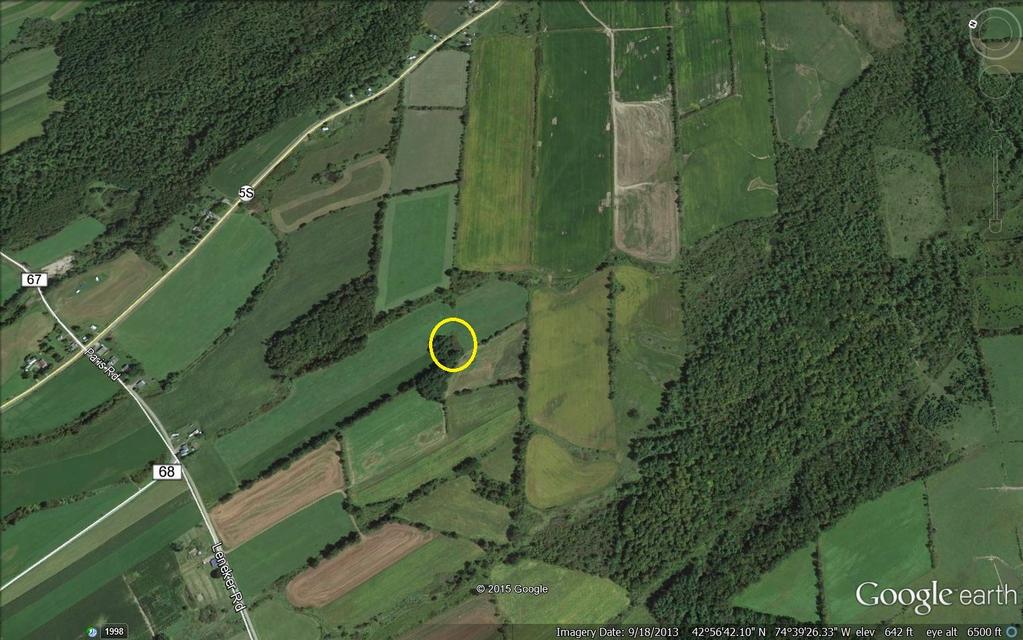
9 It is most probable that Theobald and family resided on Lot 15 where Crum Creek traverses most of the property and is within what is today the village of St. Johnsville, the property line cutting across W. Main Street where Crum Creek Road joins it (Highway 5) with perhaps the home being along the along the creek to the west of this junction. There is no evidence available which would allow a more specific indication of the home site. Theobald sold his land in the Harrison patent on 10 July While, as will be noted later, his sons Adam and Frederick were by this time becoming land speculators and entrepreneurs, purchasing land on the south side of the River from the Mohawks as early as 1751, Adam appears to have moved across the River, but to a proximal property across from the lands in the Harrison Patent moving from what became the Palatine District to the Canajoharie District. All future purchases would be on the south side of the River. 9

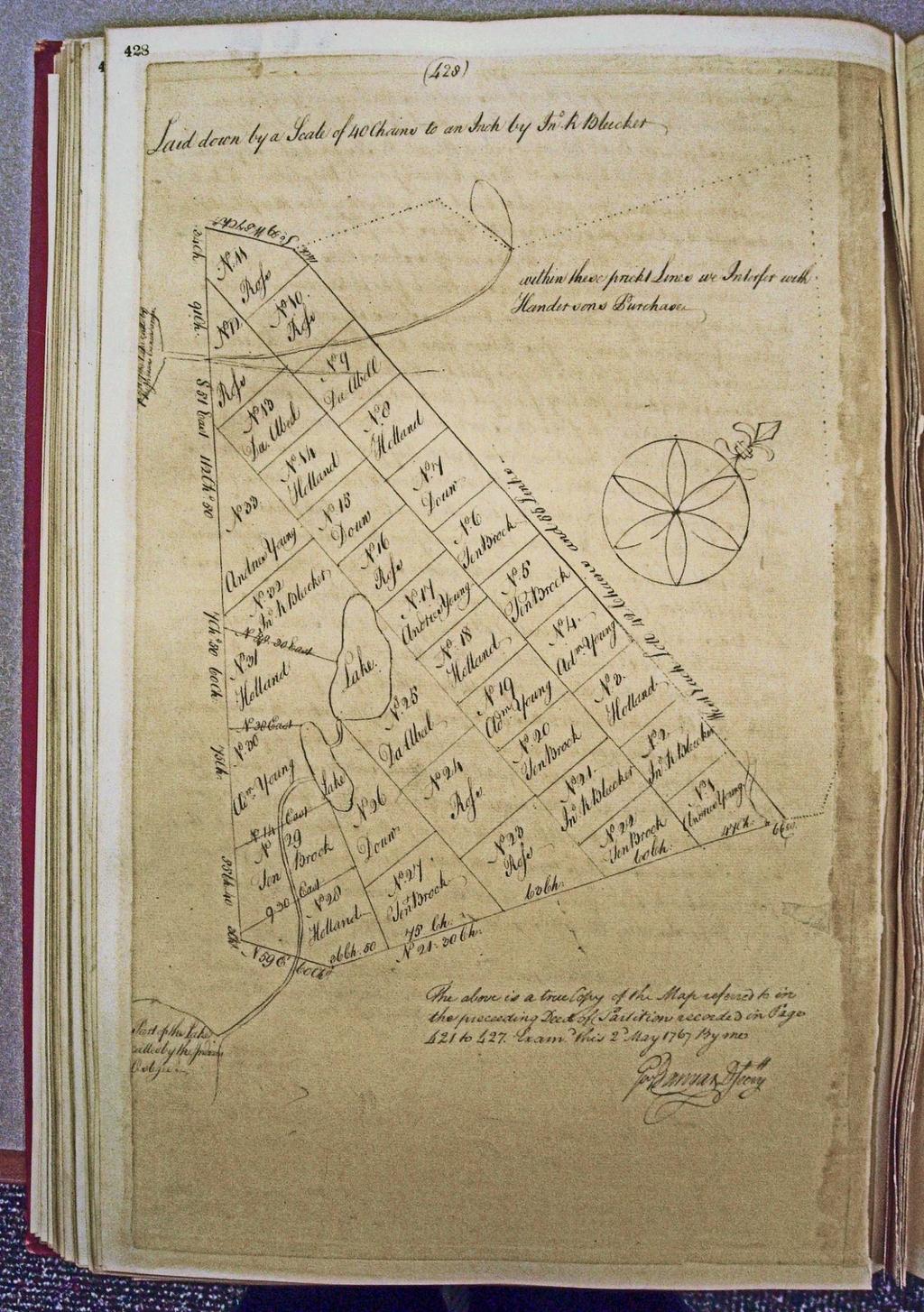
10 Map of some of the Major Purchases in the Canajoharie District: Marked in yellow on the left is the Theobald Young Patent (owned largely by Theobald and his sons), and to the right the Frederick Young patent. Frederick was Adam s younger brother and also purchased lands in nearby Patents, likely becoming very wealthy in the process. The Van Horne Patent surrounds to the north the Hartmann Windecker Patent shown as the other yellow patch in the above map. Maps Showing the Harrison, Van Horne and Bleeker Patents: The following map provides an overview of the lands owned by Theobald and Adam Young in the Canajoharie District. Other purchases will be in the region south of the Mohawk Valley down to the Susquehanna headwaters. 10

11 Van Horne Patent: Adam Young s property here is on Lot 6 in the Third Allotment of the Van Horne Patent. This land is located on the south side of the Mohawk River, fronting along the River for about three quarters of a mile. It is less than two miles from Ft. Hendrick where the Mohawk Indians had their Castle. Adam's name appears on the map of this Patent (seen below) as of 10 October Since Adam was the first born son, it is possible that by then he had inherited this property from his father Theobald. It is apparent that Adam s eldest son John was still residing on the property near the Upper Mohawk Village immediately prior to the time the deed for the Bleeker property from his father (see Bleeker Patent below) was issued. In one of the account books of Jelles Fonda is an entry dated 5 November 1770 for "Hannes Young now Near Ct. Seibers his son John". The Canajoharie Tax List for 1766 shows Hannes Seeber located among a group of individuals residing on the Van Horne Patent around Adam Young's parcel shown in the map (noted previously) of He is likely the Young Seiber residing in house 24, whereas Adam Young s home was number 23. John's name does not appear here since he was only occupying the property, his father Adam was the owner. At some point in the early 1770s however, John moved to the property in Bleecker Patent. Adam sold the land in the Van Horne Patent "at the Commencement of the late war" to one Thomas Young, son of Johan Christian Young (no relation to Adam Young) who was then in possession of the property. An entry in the court 11

12 records may relate to some aspect of the sale. On 2 March 1776 John Young sued Thomas Young for 3 pounds, 15 shillings. Above is a list of those with homes in the Van Horne Patent. Below is a view of the east and west aspects of the Patent in
13 13

14 Locating this home site on a modern map such as the above is difficult due in part to the dramatic changes on the south shore of the Mohawk River by the Erie Canal works, and the New York State Thruway. It would appear that the Adam Young home was immediately across from Theobald s Lot 18 in the Harrison Patent where the River makes a bend south at the west end of what has now become an island (thanks to the Erie Barge Canal) just west of the cluster of small islands before West Canada Creek on the North side. Across from the latter and extending to Nowadaga Creek seen at the far western end of the above map on the south shore were the lands of the Canajoharie (Upper) Mohawk Castle. There does not appear to be a way to access the property, although one could get reasonably close by taking River Road to the end from Mindenville Road and Road 65 which crosses the Canal and heads west. Bleeker Patent: The tax list of 1766, however, lists Adam Young near his brothers, and among others residing on or near the north end of the Bleecker Patent near the Geissenburg Settlement. Therefore about this time Adam probably settled near present-day Ft. Plain on the south side of the Mohawk River. Adam probably moved to land (Lot 4, Bleecker Patent) adjoining that of his brother Frederick near the Canajoharie (Sand Hill) Reformed Church, which he (Adam) helped found. The map that follows shows Adam s property in the Bleeker Patent. It appears that he only owned 105 acres here (both the deed confiscated by the Rebels, and the petition of Lt. John Young for compensation after the War confirm the size of the property). Thus the section marked John Young was not part of the holdings. On 25 Apr Adam deeded a 105 parcel of land at Canajoharie (Lot 4, Bleeker Patent) on the Mohawk River (near Ft. Plain) to his son John, adjoining the 250 acre farm of the former's brother Frederick Young. John lived here until March 1771 when he was to be apprehended for burning Foxes Mill, and thus left for British Lines at Oswego or Niagara. A specific description of this property occupied by John Young at the time of the Revolution may be of interest. Reference to the Loyalist Claims data indicates that the farm was 105 acres 14
15 in extent, and that Adam was "offered 1000 pounds New York Currency by Peter Ramsay in New York sometime before 1771." In terms of the exact location of John's residence, the original deed to John from his father states that it is on Lot 4 of the Highland Patent deeded to the Bleeckers. A map composed about 1772 shows Adam on what was then (the lots were renamed and renumbered) 210 acres of the "Wood Lotts" Lot 2 at the northern section of the Bleecker Patent, opposite a large island in the Mohawk River. Apparently the lots were severed in two (105 acres each) and Adam had the portion which was the west section (furthest from the river). This was a remote location, above the Dutchtown Road. Plotting the dimensions of this lot on modern maps, it is apparent that Adam / John's residence was at the location where, in 1853 A. Ornt was residing. These individuals were descendants of Abraham Arndt who, on 26 January 1786, bought this property (Lot 2, Rutgert Bleecker Patent, 105 acres) from the Loan Officers of the City and County of Albany. Arndt paid 112 pounds for the land (the buildings had been destroyed during the Revolution 10 years earlier) in a programme where monies were raised by the sale of confiscated lands to help the State pay its debts. Interestingly, a publication of 1878 provides a detailed engraving of the "Res. of Alfred Arndt Town of Minden", which shows a large two story Georgian style house with a complex of barns and out buildings, and the well pump just to the right of the raised laneway, near the apparent drive shed, with a house situated in the distance. The map compiled by the Army Map Service Geological Survey in 1943 (Ft. Plain) shows no buildings on the site, but a prominent tongue shaped eminence, the tip of which is where is all likelihood the farm complex was located. A narrow ridge shown was probably the area along which the laneway ran. In June 1990, Ken Johnson now of Ft. Plain, NY and the author visited the site and walked along a narrow tree lined ridge to a wooded copse of about half an acre. In a site to the left (south) of the laneway ridge, a deep stone lined well was located in an area of scrub brush - with the pump leaning inside the well shaft. Further down the tongue of land, where it dipped sharply, was found an area of about 50 feet square where there was a heavy scatter of brick, stone, cinders, and household artifacts (e.g., tea cups, a decanter stopper), some of which are dateable to the late 1700s (e.g., pearlware, queensware). This spot is situated in proper relationship to the laneway and pump shown in an engraving of the property. 15

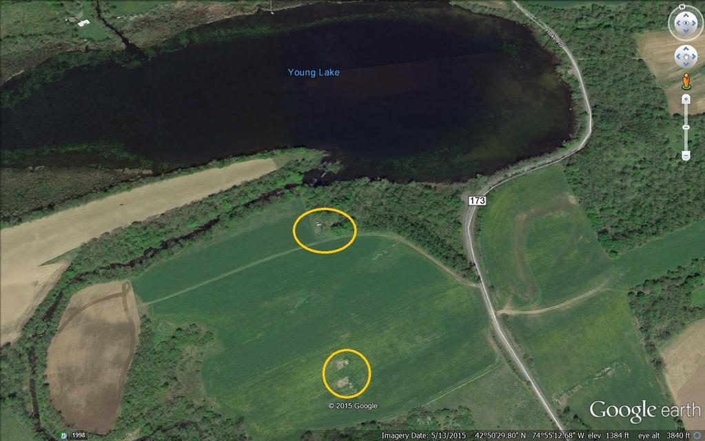
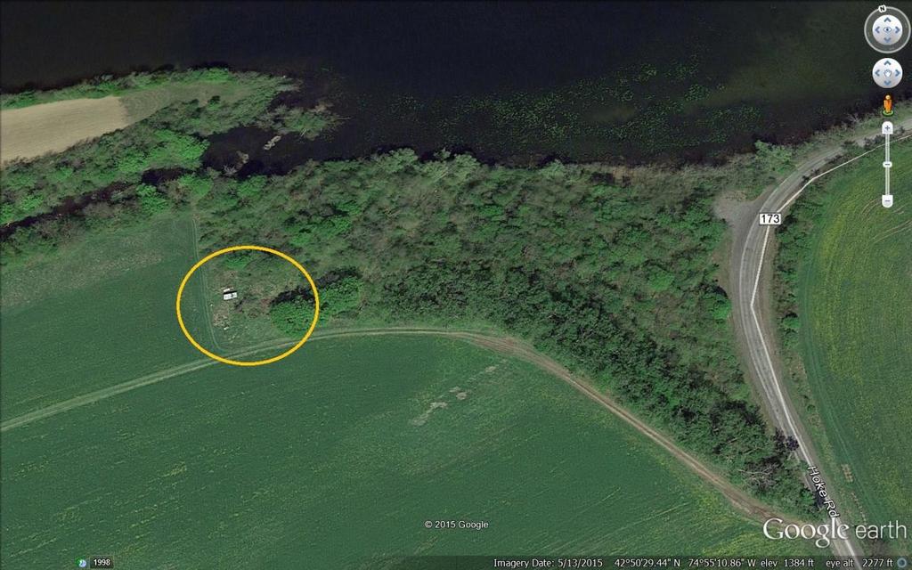
16 Above is the 1732 Bleeker Patent with the Lots as of 1772 shown. In the map below, the location of the homes of Adam Young and Conradt Mathias are shown in conjunction with modern roads. 16
17 17
18 Copy of original upon which the previous map was made. 18
19 19

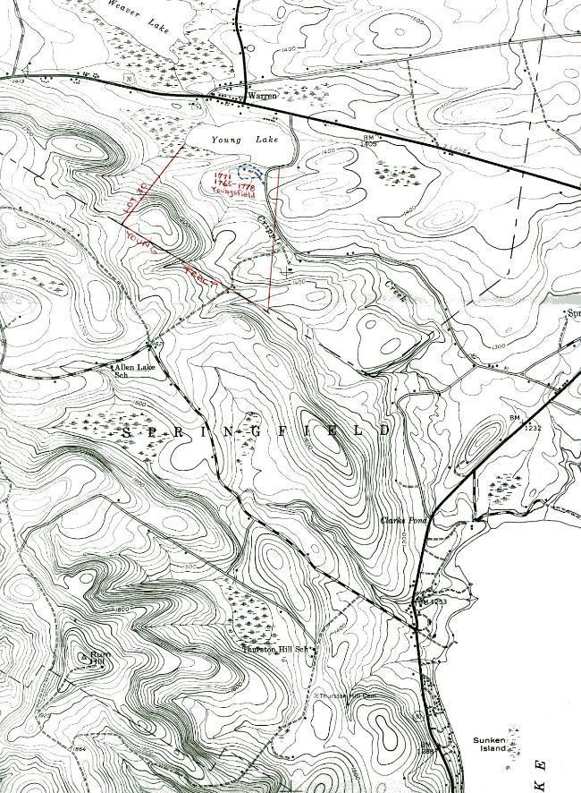
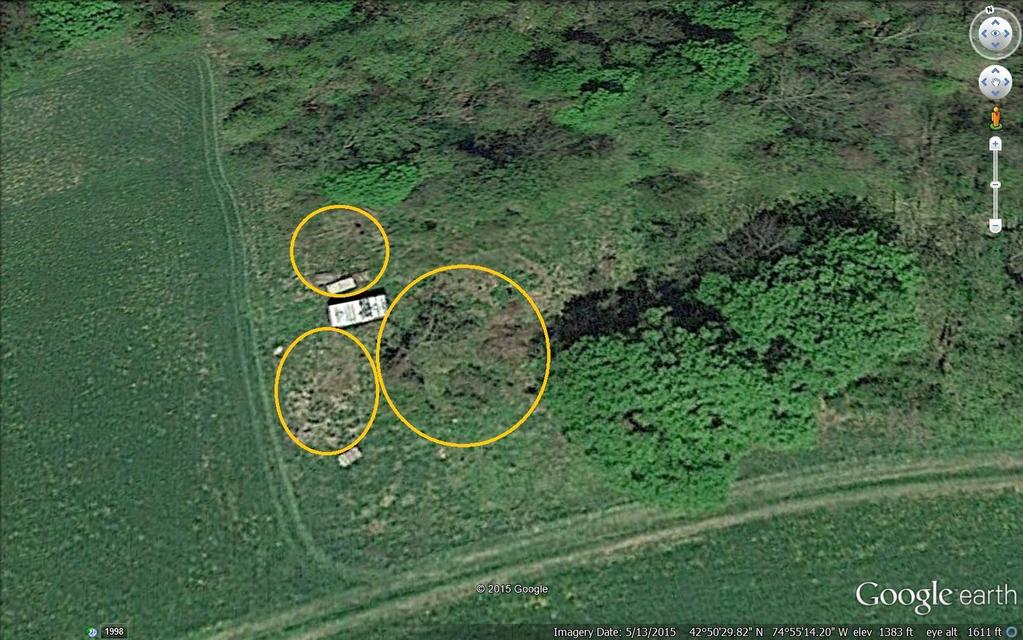
20 The above three aerial maps show the Adam / John Young home sites in the Bleeker Patent. John did not own the land shown in the first map, only the upper 105 acres plot owned previously by his father Adam Young. It should be noted that it is not known from any documentation where Daniel Young was residing. One might assume that he was residing where his father Adam Young lived. However at the time of the Revolution, it is likely that he was residing with his Uncle Frederick, near his brother John Young as all three appear to have left at the same time to travel to the British Lines at Oswego or Niagara. Henry and David, the youngest sons of Adam, were living with he and their mother Catharine Elizabeth (Schremling) Young until forced to leave the property in the Theobald Young Patent in 1778 when the Rebels burned Adam s home and business enterprises. Theobald Young et al. Patent: On 14 July 1752 Theobald and his sons Adam, Frederick, and Andries obtained a patent to 14,000 acres of land on the south side of the Mohawk River; having petitioned for permission to purchase the land 31 May 1751, and having bought the land from the Mohawk Indians 21 May On 29 Oct the deed of partition to Young's Patent was composed, and soon thereafter Adam moved to Lot 19 on the south side of Young's Lake (Youngsfield, now Warren, Herkimer Co.). 20
21 21

22 The move to Young s Lake probably took place around the time when Adam and wife Catharine Elizabeth transferred the land in the Bleeker Patent to their eldest son John Young, in It is fortunate that a description of Adam's house survives. In a letter from Garret Abeel to his wife Mary, dated 27 May 1772, he describes a trip he took from the Mohawk River to Youngs Lake. Apparently after traversing miles of deserted wilderness, on the 23rd of May, "when through the Woods I saw as by appearance the Ocion, I knew ye journey wo'd soon be to an end but Judge my agreeable surprise when soon After at the side of a large Lake before me appeared a very good board house with a Peaza round it, and several buildings about it and found one Adam Young with his family the possessor thereof". He also farmed, and owned a potash works, a sawmill, and an Indian trading post. In 1778, prior to his return to the Valley with Joseph Brant on 17 September to conduct a devastating raid on Valley settlements, under the orders of Rev. Daniel Gross, Adam s farm and buildings were burned. The partition of the Theobald Young Patent showing which lots Adam received, and where he chose to live from about 1771 to
23 23
24 24
25 25

26 The above three maps point out the house and outbuilding site at the south end of Young s Lake where Adam and family moved circa 1768 to Lands in Otsego County: While Adam Young never resided on the 1000 acres he purchased of Sir John Johnson in the upper reaches of the Susquehanna River at Otego, his nephews did reside on the property after the Revolution. They are included below. Conclusion: The author hopes that this work will assist Young descendants to locate the properties of their ancestors when they wish to visit the old family sites in the Mohawk Valley. Dr. David K. Faux. The author acknowledges with thanks the research assistance of Thomas M. Nelson (particularly in creating the aerial maps with boundaries and sites shown), and Ken D. Johnson who provided copies of the original patent maps. Version: 8 November
The General William Henry Harrison Trail through Portions of Vermillion County and Warren County, Indiana Written 11 October 2015 by Curtis L.
 The General William Henry Harrison Trail through Portions of Vermillion County and Warren County, Indiana Written 11 October 2015 by Curtis L. Older Five Probable Points Along the Harrison Trail, including
Benedict Alford August 26, 1716 After 1790 By: Bob Alford 2010
 Benedict Alford August 26, 1716 After 1790 By: Bob Alford 2010 Benedict Alford was the oldest child of Benedict Alford and Abigail Wilson. He was born August 27, 1716 in Windsor, CT, according to Windsor
Boone County. and the Revolutionary War. By: Robin Edwards Local History Associate
 Boone County and the Revolutionary War By: Robin Edwards Local History Associate Typically the first places that come to mind when asked about the Revolutionary War are Lexington and Concord. After all,
Descendants of Brant Canagaradunkwa
 Descendants of Brant Canagaradunkwa Generation 1 1. BRANT 1 CANAGARADUNKWA was born in Feb 1697 in pr. North Bank, Mohawk Valley, New York, USA. He died after 10 Mar 1763 in Pr. Canajoharie, Upper Mohawk
WAR OF 1812 LINCOLN MILITIA SERVICE RECORDS FOR THE DESCENDANTS OF ADAM YOUNG ( ) OF THE GRAND RIVER HALDIMAND TRACT, ONTARIO, CANADA
 OF THE GRAND RIVER HALDIMAND TRACT, ONTARIO, CANADA") WAR OF LINCOLN MILITIA SERVICE RECORDS FOR THE DESCENDANTS OF ADAM YOUNG (1717-1790) OF THE GRAND RIVER HALDIMAND TRACT, ONTARIO, CANADA (First Draft) By David K. Faux Introduction: Included here are the
WAR OF LINCOLN MILITIA SERVICE RECORDS FOR THE DESCENDANTS OF ADAM YOUNG (1717-1790) OF THE GRAND RIVER HALDIMAND TRACT, ONTARIO, CANADA (First Draft) By David K. Faux Introduction: Included here are the
Old Sandy Baptist Church Graveyard
 Old Sandy Baptist Church Graveyard By Dave Hallemann This original church cemetery is located in T41 R4 Survey 2018 in what was at one time called the Upper Sandy Settlement off Highway 21. It was visited
John Miller ( )
") John Miller (1724-1803) Thomas E (1761-1830) Jacob (1782-abt 1845) Francis Marion (1826-1894) Jacob Franklin(1866-1949) Horace Francis (1905-1974) James Richard (1931-) James Aaron (1954-) John Miller
John Miller (1724-1803) Thomas E (1761-1830) Jacob (1782-abt 1845) Francis Marion (1826-1894) Jacob Franklin(1866-1949) Horace Francis (1905-1974) James Richard (1931-) James Aaron (1954-) John Miller
Chapter II: Environmental Setting
 Section 1. Regional Profiles Chapter II: Environmental Setting The Oneida Lake watershed is situated within the Oswego-Seneca-Oneida Rivers Drainage Basin that drains to Lake Ontario, through the Gulf
Thomas Eames Family. King Philip s War. Thomas Eames Family in King Philip s War Josiah Temple The Thomas Eames Family.
 Thomas Eames Family in King Philip s War Josiah Temple The Thomas Eames Family was trying again to make a go of it. Thomas and his wife Mary had each been widowed and had children that they brought to
Donald H. Klock. William Klock--K-Hill Farm
 Publisher: Dave Klock 262 North Snyder St. P.O. Box 402 Marcellus, Michigan 49067 Issue No. 39 Date:October 2004 Phone: 269-646-3085 E-mail: Klock@swmcom.net and Sara. The children live with their mother
THE WELLINGTONS OF TRAPELO ROAD by Elizabeth Castner 1
 THE WELLINGTONS OF TRAPELO ROAD by Elizabeth Castner 1 Roger Wellington was in Watertown as early as 1636. He lived first in the eastern part of the town, his homestall being mostly in Mt. Auburn but was
Christian Street Rural Historic District
 Christian Street Rural Historic District Historic Tour No.6 in the Town of Hartford, Vermont Agricultural open space defines the Christian Street Rural Historic District, a 198-acre hamlet in the northeast
JOSEPH HOWELL - REVOLUTIONARY SOLDIER OF OLD BARNWELL DISTRICT, S.C. AND ALLIED FAMILIES,
 Joseph Howell (Father of Jesse Howell) pg 1/6 Born: 1754 Cheraw, South Carolina Married: Elizabeth Kirkland Died: 7 Aug 1836 Barnwell, South Carolina Parents: Unknown JOSEPH HOWELL - REVOLUTIONARY SOLDIER
Bradley Rymph IN THE FOOTSTEPS OF OUR ANCESTORS
 IN THE FOOTSTEPS OF OUR ANCESTORS RESTLESS PIONEERS Samuel Wilson King (1827 1905) & Margaret Taylor Gerrard (1831 1892) / Albert James Rymph (1851 1926) & Luella Maria King (1861 1949) Bradley Rymph The
THE close of the revolutionary war and the return of peace marked
 AFTER THE REVOLUTION. CHAPTER XII. Condition of the Mohawk Valley at the close of the Revolution Mohawk Indian? Forfeit their Lands to the State Return of the Tories Their Treatment by the Mohawk Committee
Historical Society of Whitpain local history collection
 01 Finding aid prepared by Celia Caust-Ellenbogen and Michael Gubicza through the Historical Society of Pennsylvania's Hidden Collections Initiative for Pennsylvania Small Archival Repositories. Last updated
Glade District, Oglethorpe County, Georgia Location: end of Pea Ridge Road, N W
 Glade District, Oglethorpe County, Georgia Location: end of Pea Ridge Road, N 34 00 05 W 83 02 40 Research and narrative by descendants: Mr. Glenn M. Paul and Dr. Michael M. Black Buried in this cemetery
Descendants of Aurie Kanaghowende Hill
 Descendants of Aurie Kanaghowende Hill Generation No. 1 1. AURIE KANAGHOWENDE 1 HILL was born Abt. 1660 in pr. Ossernenon, South Bank, Mohawk Valley, New York, USA, and died Aft. December 28, 1735 in pr.
1 of 1 4/6/2007 1:07 PM
 Navigation - Family Topics http://virginians.com/topics/navigation.htm 1 of 1 4/6/2007 1:07 PM 1 of 5 4/6/2007 1:07 PM Ancestral Family Topic 414 414 James Hill (1726-1765) James Hill, in his own words
HUNT FAMILY HISTORY. The Ancestors and Descendants of Major Samuel Hunt of Washington County, Tennessee
 HUNT FAMILY HISTORY The Ancestors and Descendants of Major Samuel Hunt of Washington County, Tennessee By Robert M. Wilbanks IV Scottsdale, Arizona 2004 (2004 revision of original compiled in 1988; reflecting
Barbara Chisholm, War of 1812
 Barbara Chisholm, War of 1812 Anticipating the end of the War declared on Upper Canada on June 18, 1812, Barbara Chisholm reminds the people of her community of the events and the people the war has affected.
Why is the Treaty at Logstown in 1748 so important? What did it do?
 Student Worksheet A Shot in the Backwoods of Pennsylvania Sets the World Afire Worksheet 1: Focus Questions for "The Roots of Conflict" Instructions: Your group may answer these questions after the reading
council met at the home of William Latimer, from 1840 to 1846 at the home of William Vance and later at Tooley s Tavern in Blackstock.
 6 council met at the home of William Latimer, from 1840 to 1846 at the home of William Vance and later at Tooley s Tavern in Blackstock. Cartwright was the smallest of the original six townships of Durham
Elyse: I m Elyse Luray, and I ve come to see Dan and Sharon s Front Street home for myself.
 Season 6, Episode 7: Front Street Blockhouse Elyse Luray: Our final story investigates a seemingly ordinary house with a potentially extraordinary past. February 8 th, 1690: a winter storm buries the frontier
Johann Erhart Knappenberger Freundschaft
 Johann Erhart Knappenberger Freundschaft HISTORY of the Johann Erhart Knappenberger Freundschaft From 1749 to 1916 Compiled and Arranged by Vinnie E. Knappenberger Greensburg, Pa. Author's Explanatory
From Slave Owner s Son to African Baptist Church - how one parcel of land transferred in Digby County, Nova Scotia
 From Slave Owner s Son to African Baptist Church - how one parcel of land transferred in Digby County, Nova Scotia By Brian McConnell, UE* A short distance along the main road outside the Town of Digby,
"Father of Brownwood"
 from; THE PROMISED LAND A HISTORY OF BROWN COUNTY, TEXAS by James C. White "Father of Brownwood" GREENLEAF FISK is a name that is engraved indelibly upon the tablets of Brown County's history, and is known
THE LATE GREAT PUGET SOUND MERIDIAN. Washington State s Own Principal Meridian. by Denny DeMeyer
 THE LATE GREAT PUGET SOUND MERIDIAN. Washington State s Own Principal Meridian by Denny DeMeyer Pausing briefly in a clearing in the forest while ascending a ridge just south of Bellingham, the surveyors
Jackson-Jones Family Collection,
 Jackson-Jones Family Collection, 1685-1865. Special Collections Department/Long Island Studies Institute Contact Information: Special Collections Department Axinn Library, Room 032 123 Hofstra University
Henry H. Van Dyck Correspondence (bulk ) Brooklyn Historical Society Othmer Library 128 Pierrepont Street Brooklyn, NY 11201
 Brooklyn Historical Society Othmer Library 128 Pierrepont Street Brooklyn, NY 11201") ArMs 1977.045 A0086-A0089 4 Document Boxes, 2.0 Cubic feet RLIN No. NYKI590-940-0746 4.C - 6.5.E 1840-1869 (bulk 1865-1869) Othmer Library 128 Pierrepont Street Brooklyn, NY 11201 Tel. 718.222.4111 FAX
ArMs 1977.045 A0086-A0089 4 Document Boxes, 2.0 Cubic feet RLIN No. NYKI590-940-0746 4.C - 6.5.E 1840-1869 (bulk 1865-1869) Othmer Library 128 Pierrepont Street Brooklyn, NY 11201 Tel. 718.222.4111 FAX
Michael Bechtel, Theresa Kroening, Peter Smith Michael Sieczkowski, alternate
 January 23, 2012 The regular monthly meeting of the ZONING BOARD of APPEALS of the TOWN of CAMBRIA was called to order by John Reardon, Chairman, at 8:00 P.M. He welcomed everyone to the meeting followed
Johnston Farm & Indian Agency. Field Trip Guide
 Johnston Farm & Indian Agency Field Trip Guide Table of Contents Introduction to Field Trip Guide 2 Mission Statement and Schools 3 Objectives and Methods 4 Activities Outline 5 Orientation Information
MSS: FH810 LUDLOW FAMILY PAPERS Processed By: Scott McCloud Volume: 8 Boxes, 2.5 lin. ft. June 1990
 MSS: FH810 LUDLOW FAMILY PAPERS 1743-1929 Processed By: Scott McCloud Volume: 8 Boxes, 2.5 lin. ft. June 1990 Provenance: The 8 account books and 94 letters were donated by Mrs. John A. Gorton. The remainder
The Webbs. A Tompkins County Family
 The Webbs A Tompkins County Family In honor of our county s bicentennial The History Center is celebrating one long-established family from Caroline, the Webbs and their descendants, who exemplify the
KNOW YOUR ROOTS. A Family That Doesn t Know Its Past Doesn t Understand Itself. Volume IX Issue 1 DURLAND February 2004
 KNOW YOUR ROOTS A Family That Doesn t Know Its Past Doesn t Understand Itself Volume IX Issue 1 DURLAND February 2004 DR. JAMES THACHER DESCRIBES THE HARDSHIPS OF THE WINTER ENCAMPMENT AT MORRISTOWN *
R E S O L U T I O N. B. Development Data Summary:
 R E S O L U T I O N WHEREAS, the Prince George s County Planning Board has reviewed Certification of Nonconforming Use Application No. CNU-45423-2016 requesting certification of a nonconforming use for
JACOB KRAUS (Grouse)
") JACOB KRAUS (Grouse) BORN 1690 Germany Rhine Palatinate ffi*/» MARRIED Jun 24 1724 Catherine Elizabeth Nellis (? -1754) by Rev Ehle This was the first known wedding in the Fort Plain area.jacob lived in
JACOB KRAUS (Grouse) BORN 1690 Germany Rhine Palatinate ffi*/» MARRIED Jun 24 1724 Catherine Elizabeth Nellis (? -1754) by Rev Ehle This was the first known wedding in the Fort Plain area.jacob lived in
John was a Revolutionary War Veteran and served as a private. See account book 1784, page 2, VA State Library.
 HANCOCK, JOHN DAR Ancestor #: A050862 Service: VIRGINIA Rank: PATRIOTIC SERVICE Birth: CIRCA 1733 GOOCHLAND CO VIRGINIA Death: POST 11-10-1802 PATRICK CO VIRGINIA Service Source: ABERCROMBIE & SLATTEN,
Charles Carroll (of Bellevue) PapersD.488
 PapersD.488") This finding aid was produced using ArchivesSpace on October 06, 2015. English Rare Books, Special Collections, and Preservation Department Rare Books Special Collections Preservation Second Floor Map
This finding aid was produced using ArchivesSpace on October 06, 2015. English Rare Books, Special Collections, and Preservation Department Rare Books Special Collections Preservation Second Floor Map
Mesa s Beginning. The Jones (Lehi) Company
 Company") Mesa s Beginning The Jones (Lehi) Company 1875 In late 1876 Mormon Church officials asked Daniel Webster Jones to lead a colonizing party south into Mexico. Jones stated he did not want the responsibility
Mesa s Beginning The Jones (Lehi) Company 1875 In late 1876 Mormon Church officials asked Daniel Webster Jones to lead a colonizing party south into Mexico. Jones stated he did not want the responsibility
Comal Settlement CONTEXT
 Comal Settlement CONTEXT Comal, Texas (now an annexed portion of Schertz, Texas) sits amidst land through which traverses the El Camino Real de los Tejas Historic National Trail System (AKA: Kings Highway
Town of Fayette Planning Board 1439 Yellow Tavern Road Waterloo, NY
 Town of Fayette Planning Board 1439 Yellow Tavern Road Waterloo, NY13165 315-585-6282 Minutes for March 27, 2017 The Town of Fayette s Planning Board March 27, 2017 meeting was called to order at 7:02PM
Copyright 2016 by Gary Boden and the Exeter Historical Association
 The Horn Heap Among the landmarks of Exeter, there s a nearly forgotten one with a strange alliterative name. It s called the Horn Heap and its story goes back to the very earliest days of the Rhode Island
194 Elizabeth R. H oltgreive
 RECOLLECTIONS OF PIONEER DAYS To the pioneers I am known as Betty Shepard. I was born October 26th, 1840, in Jefferson County, Iowa, at a place called Brush Creek, about fifteen miles from Rome. My father,
UNY Historical News & Views
 UNY HISTORICALNEWS & VIEWS Issue 1 2018 UNY Historical News & Views UNY UNITED METHODIST HISTORICAL SOCIETY - PRESERVE THE PAST; INFORM THE FUTURE UNY Methodist History recognized from reports on UNY-UMHS
Dorcas, a Free Person of Color in Washington County *Note The spelling was not changed from the original records.
 Dorcas, a Free Person of Color in Washington County *Note The spelling was not changed from the original records. Christopher Taylor was one of the early settlers of Washington County, Tennessee. He was
JOSEPH WIKERSON, SCIPIO, AND HC. I don t know what HC stands for! In all my searching, all these years, I have
 JOSEPH WIKERSON, SCIPIO, AND HC I don t know what HC stands for! In all my searching, all these years, I have found no document or evidence to suggest what these initials mean. I start with this point
Branch 13. Tony McClenny
 by Tony McClenny Descendants of William Clenney Generation No. 1 1. WILLIAM 1 CLENNEY was born Abt. 1684 in Wilmington, New Castle County, Delaware, and died in St. Mary's District (Hillsborough District),
Our Oldest Churches. There was also a Baptist group but records were not kept so it is difficult to say what began and when.
 Our Oldest Churches Actually remains of our Oldest Churches no longer exist in the Warren Township area. Some remains existed in the Mt Clemens area and were dated about 2,000 years from present. Pioneers
Background of the Landing:
 Background of the Landing: In May, we celebrate the Landing of the Mohawks at the Bay of Quinte. During the American Revolution the Fort Hunter Mohawks had been forced to leave their home in Mohawk Valley.
MECKLENBURG TO LANARK
 MECKLENBURG TO LANARK An Administrative Evolution Following the Conquest (1759) the Quebec Act (1774) incorporated what are now eastern Canada and the southern portions of present day Quebec and Ontario
Teaching Point: Why was geography, culture, economics, religion, and politics important to the growth of the Middle Colonies?
 Teaching Point: Why was geography, culture, economics, religion, and politics important to the growth of the Middle Colonies? Middle Colonies (New York, New Jersey, Pennsylvania, Delaware) Category Using
NUGGETS of HISTORY. Last Kishwaukee Settlement on Stillman Valley Road South of Kishwaukee School
 NUGGETS of HISTORY March-April, 1968 Volume V, Number 3 THIS WAS KISHWAUKEE By William J. Condon The early history of Kishwaukee Community has been given only brief notice in various publications of the
MS-543: Middle Run Primitive Baptist Church Preservation Association, Inc., Records
 Collection Number: MS-543 MS-543: Middle Run Primitive Baptist Church Preservation Association, Inc., Records Title: Middle Run Primitive Baptist Church Preservation Association, Inc., Records Dates: 1799-2003
Receipt for land purchased from the Six Nations, Introduction
 1 Introduction This document records that the representatives of the Six Nations, who signed using totems to designate individuals and tribes, received $10,000 as payment from the Penns for land the tribes
Descendants of Henry Sterling of Providence Rhode Island 18 Mar 2002
 FIRST GENERATION 1. Henry Sterling of Providence Rhode Island was born in 1726 near Londonderry, Ireland. 1 He resided Providence, Rhode Island in 1756 in Providence, Rhode Island. 2 He resided Sterling,
what an appraiser does is to adjust one property so that it equals the other property) and instead of raising a number he lowered it and instead of lo
 and instead of raising a number he lowered it and instead of lo") CONDEMNATION Some time in 1984/1985 the City of Round Rock resolved that what they needed was a City park and what better place for a City park than the 427 acres known as the Palm estate. At this point
CONDEMNATION Some time in 1984/1985 the City of Round Rock resolved that what they needed was a City park and what better place for a City park than the 427 acres known as the Palm estate. At this point
THE ONEONTA ROUNDHOUSE
 THE ONEONTA ROUNDHOUSE Jim Loudon Second Edition BOOK PREVIEW SQUARE CIRCLE PRESS VOORHEESVILLE, NEW YORK The Oneonta Roundhouse Published by Square Circle Press LLC 137 Ketcham Road Voorheesville, NY
Mohawk Wyandot Ancestry of Lt. John Young s First Wife: Catharine Brant-Hill Kayakhon
 Mohawk Wyandot Ancestry of Lt. John Young s First Wife: Catharine Brant-Hill Kayakhon by David K. Faux Evidence Relative to the Wives of John Young: Lt. John Young, who served in the Six Nations Indian
Joseph Talcott Governor of the Colony of Connecticut,
 Joseph Talcott Governor of the Colony of Connecticut, 1724-1741 Born: November 16, 1669, Hartford, Connecticut College: None Political Party: None Offices: Various Offices, Town of Hartford, 1692-1705
TONY BOSTOCK S LOCAL HISTORY NOTES: SWANLOW
 TONY BOSTOCK S LOCAL HISTORY NOTES: SWANLOW THE OLD STAR INN Originally, in the 18 th century at least, The Old Star was called The Starr. It subsequently became the Old Star in the mid 19 th century and
PPS RECORDS FOR 125 HOPE STREET PLAT 17, LOT 602
 PPS Records for 125 Hope Street Page 1 NOTES PPS RECORDS FOR 125 HOPE STREET PLAT 17, LOT 602 JOSEPH S. COOKE HOUSE Built 1819 at the corner of Hope and Power Streets; Moved to this location in 1885 by
Lampercock Spring Farm
 Colonial home, circa 1750-1770 Listed by New England, Realtor MLS ID # 1085380 Price $449,900.00 Includes 2.45 Acres Lampercock Spring Farm Please call us for more details... New England, Realtor 260B
Mother: Betsy Bartholomew Nicholson ( ) Married: Alice Samantha Fowles in Born in 1843
 Married: Alice Samantha Fowles in Born in 1843") Ezra Nicholson (February 8, 1835 January 15, 1915) Buried at Lakeview Cemetery Father: James E. Nicholson (1783 1859) Mother: Betsy Bartholomew Nicholson (1792 1879) Married: Alice Samantha Fowles in 1863.
Ezra Nicholson (February 8, 1835 January 15, 1915) Buried at Lakeview Cemetery Father: James E. Nicholson (1783 1859) Mother: Betsy Bartholomew Nicholson (1792 1879) Married: Alice Samantha Fowles in 1863.
The Reverend Nathaniel Fanning Homestead 1372 Flanders Road, Flanders Southampton, Long Island, New York May 2015, Sally Spanburgh
 The Reverend Nathaniel Fanning Homestead 1372 Flanders Road, Flanders Southampton, Long Island, New York May 2015, Sally Spanburgh Public View of Property, April 2015 The Rev. Nathaniel Fanning Homestead
Look straight ahead as you pull out of the church lot. This land in front of you was where the Onesquethaw School was located.
 N.B. This is an extract from the full tour guide and includes maps and information for the following tour(s) only: Feura Bush Unionville 1 Vanderbilt/ DeLong House Walter Groesbeck House Continuing down
HALDEMAN/STEHMAN RESEARCH
 HALDEMAN/STEHMAN RESEARCH (The following material was found as one document at the Lancaster County Historical Society. It probably had been transcribed one or more times from original sources. This copy
FIRST SETTLERS BURIAL GROUND
 FIRST SETTLERS BURIAL GROUND 1635 TRUSTEES Douglas A. Noyes Patrick Gormley McDonough Mac Scanlon First Settlers Burial Ground Rules & Regulations The mission of the Trustees of the First Settler s Burial
It was near this spot that J. D. Lee operated his ferry across the Colorado. Photo Paul Fretheim
 It was near this spot that J. D. Lee operated his ferry across the Colorado. Photo Paul Fretheim CLICK IN IMAGE TO OPEN A 360 PANO OF THIS LOCATION. Topo Map: Glen Canyon Dam; Coordinates: 36 52 N - 111
GHM ARCHIVES MSS. COLL. #17. MSS. Collection #17. John Hanner Family Papers, [bulk 1850s-1880s]. 1 box (16 folders), 110 items.
![GHM ARCHIVES MSS. COLL. #17. MSS. Collection #17. John Hanner Family Papers, [bulk 1850s-1880s]. 1 box (16 folders), 110 items.](/thumbs/93/114526095.jpg "GHM ARCHIVES MSS. COLL. #17. MSS. Collection #17. John Hanner Family Papers, [bulk 1850s-1880s]. 1 box (16 folders), 110 items.") MSS. Collection #17 John Hanner Family Papers, 1809-1912 [bulk 1850s-1880s]. 1 box (16 folders), 110 items. INTRODUCTION The John Hanner Family Papers primarily relate to Allen Armstrong Hanner, one of
MSS. Collection #17 John Hanner Family Papers, 1809-1912 [bulk 1850s-1880s]. 1 box (16 folders), 110 items. INTRODUCTION The John Hanner Family Papers primarily relate to Allen Armstrong Hanner, one of
Analysis of Letter from Hugh Blakeney to Elminey Guess Letter dated March, 1865
 Analysis of Letter from Hugh Blakeney to Elminey Guess Letter dated March, 1865 A transcription of this letter was found on the internet from multiple sources. The source of the first transcription and
Jacob Showalter (Abt ) of Northampton Co. PA Patriarch of the Showalters of Rockingham County, VA
 of Northampton Co. PA Patriarch of the Showalters of Rockingham County, VA") Jacob Showalter (Abt. 1710-1773) of Northampton Co. PA Patriarch of the Showalters of Rockingham County, VA Including a transcription of his Last Will and Testament Susan McNelley Farmland in Rockingham
Jacob Showalter (Abt. 1710-1773) of Northampton Co. PA Patriarch of the Showalters of Rockingham County, VA Including a transcription of his Last Will and Testament Susan McNelley Farmland in Rockingham
DUKE WILLIAM KENDRICK
 January 2006 DUKE WILLIAM KENDRICK Note: The following information has been culled from many sources. Primary document sources used include those held at the Provincial Archives of Ontario various/many
The name has been variously written Gall, Galle, Gail, Gael and Gale as well as De Galles. All sounding nearly alike, during the last century nearly
 Gale Stranger In the search for one's ancestry, surnames of progenitors multiply rapidly. Each of an individual's eight great-grandparents also has eight great-grandparents. At this seventh generation
The Colony of Virginia as Far as the Mississippi
 The Colony of Virginia as Far as the Mississippi I. Background Information Among George Washington s many skills was an aptitude for mapping the land. Even his earliest surveys, done at age 16, show admirable
John Christopher Peters
 John Christopher Peters Pg 1/10 No Picture Available Born: abt 1750 in South Carolina Married: Unknown Died: abt 1809 Occupation: Farmer (assumed) Family: Wife: Unknown Children: William Joseph John Christopher
Hallowed Grounds: Sites of African-American Memories. Courtesy of the archival collection at the Albany County Hall of Records
 Hallowed Grounds: Sites of African-American Memories Courtesy of the archival collection at the Albany County Hall of Records The history of African-Americans in the United States can be remembered not
Warren's Grandparents, Jeremiah Jr. and Elizabeth Daggett Reynolds
 Warren's Grandparents, Jeremiah Jr. and Elizabeth Daggett Reynolds When the Senior Jeremiah died in 1768 Jeremiah Jr., at age 20, was out of reach of the courts deciding guardianship. How or what he did
BURFORD GAZETTEER: OWNERS AND OCCUPIERS
 www.englandspastforeveryone.org.uk/explore Oxfordshire BURFORD GAZETTEER: OWNERS AND OCCUPIERS Work on the owners and occupiers of Burford s buildings was undertaken during 2003-6 as part of the Oxfordshire
Klock Connections, Linking the Past Present and Future
 Klock Connections A Klock Family Newsletter Issue 116 April 2011 Klock Connections, Linking the Past Present and Future Publisher: David Klock E mail: Daveanddarla2000@yahoo.com P.O. Box 402 Web Page:
March 19, Steve -
 March 19, 2014! Steve -! It is great to make contact with you. I do recall visiting with your mother several times during the period from 2002 thru 2004, which is when I was working on a compilation of
Historic Property. William Angus Robinson House 243 North 100 East American Fork, Utah. Year Built: 1887
 Historic Property William Angus Robinson House 243 North 100 East American Fork, Utah Year Built: 1887 Current Owner: Colleen McTague Stoors Cincinnati, OH 1 History of the William Angus Robinson Home
BROWN, JOSEPH PAPERS,
 State of Tennessee Department of State Tennessee State Library and Archives 403 Seventh Avenue North Nashville, Tennessee 37243-0312 BROWN, JOSEPH PAPERS, 1772-1965 (THS Collection) Processed by: Gracia
Old Testament Survey. numbers. Dr. Bill Egner. april 24, Part 2 (chs. 9-14) The Story Of Chapters 10-14
 The Story Of Chapters 10-14") Old Testament Survey numbers Part 2 (chs. 9-14) Dr. Bill Egner april 24, 2016 NO CLASS: May 30 (Memorial Day) June 26 July 3 Sept 5 (Labor Day) Oct 9 (Family Round-Up) BIG OUTLINE OF NUMBERS First Generation
Old Testament Survey numbers Part 2 (chs. 9-14) Dr. Bill Egner april 24, 2016 NO CLASS: May 30 (Memorial Day) June 26 July 3 Sept 5 (Labor Day) Oct 9 (Family Round-Up) BIG OUTLINE OF NUMBERS First Generation
BURYING GROUNDS AT THE PRESBYTERIAN CHURCH OF LAWRENCEVILLE
 BURYING GROUNDS AT THE PRESBYTERIAN CHURCH OF LAWRENCEVILLE Prepared by Janet A. Fearon for presentation at the 2005 Mershon Association annual meeting in Lawrenceville, PA THE FIRST MEETING HOUSE The
Genealogy and NORTH CAROLINA Counties
 1 Genealogy and NORTH CAROLINA Counties An ancestor blessed with longevity could have been born in Rowan County in 1753. married in Burke County in 1778, fathered children in the counties of Burke and
JOB COOPER. c
 JOB COOPER c.1732 1804 The word wanderlust must have been coined to describe Job Cooper, the father of Nathan Cooper. Trying to track down Job brings to mind an old family expression "slipperier than a
Being the Church in a Post-Katrina World New Orleans Area Prayer Pilgrimage February, 2007
 Welcome to New Orleans! Being the Church in a Post-Katrina World New Orleans Area Prayer Pilgrimage February, 2007 You are about to embark on a journey. It s a journey of great sorrow and loss. It s also
Church planned at site of state's first Catholic church
 Church planned at site of state's first Catholic church Xerxes Wilson, The News Journal 9:42 a.m. EST January 12, 2015 Some 225 years after a log cabin church was built at the Coffee Run Mission just south
NOVEMBER 2017 LESSON, ARTIFACT, AND MUSIC. November 2017 DUP Lesson Cove Fort Ellen Taylor Jeppson
 NOVEMBER 2017 LESSON, ARTIFACT, AND MUSIC November 2017 DUP Lesson Cove Fort Ellen Taylor Jeppson The great Mormon pioneer migration to the West began in 1847 when the pioneers made their way to the Salt
Klock Connections. Descendants of Barvalis Elizabeth Klock. Generation No. 1
 Klock Connections This Klock Family Tree was compiled by Dave Klock of Marcellus, Michigan. Some of the information is unsubstantiated and therefore may not be Reliable. All family trees have errors; they
HISTORY OF THE UNIQUE BURIAL SITE OF JOHN AND NANCY OSTEEN MOORE. by Jesse Felma Moore
 HISTORY OF THE UNIQUE BURIAL SITE OF JOHN AND NANCY OSTEEN MOORE by Jesse Felma Moore 2017 Photo This year, 2017, marks the 150 th anniversary of the death of John Moore (1790-1867), son of Caleb. In this
Descendants of Aurie Kanaghowende Hill
 Descendants of Aurie Kanaghowende Hill Generation No. 1 1. AURIE KANAGHOWENDE 1 HILL was born Abt. 1660 in pr. Ossernenon Castle (Printup Site), Mohawk Valley, New York, USA, and died Aft. December 28,
The Isenharts and the Salamonia Christian Church
 The Isenharts and the Salamonia Christian Church Church Data From: Salamonia Christian Church: 1842-1999 Judith Myers Ahrens, December 2012 Thanks to Judy for permission to use selected data from her book
Governor Robert Treat ( )
") Governor Robert Treat (1622-1710) Founder of Newark, New Jersey and Milford, Connecticut, Governor of Connecticut and Commander of Connecticut troops in King Philips War and grandfather of a signer of
Governor Robert Treat (1622-1710) Founder of Newark, New Jersey and Milford, Connecticut, Governor of Connecticut and Commander of Connecticut troops in King Philips War and grandfather of a signer of
JOHN D. JONES Father of Charles E. Jones
 JOHN D. JONES Father of Charles E. Jones John D. Jones was a most successful farmer and fruit growers of Utah County. His residence has been in Provo, Utah, most of the time since 1851. He was born in
The American Revolution. Timeline Cards
 The American Revolution Timeline Cards ISBN: 978-1-68380-024-8 Subject Matter Expert J. Chris Arndt, PhD, Department of History, James Madison University Illustration and Photo Credits Title Scott Hammond
Sutherland and Read Family Papers (MSS 468)
") Western Kentucky University TopSCHOLAR MSS Finding Aids Manuscripts 9-9-2013 Sutherland and Read Family Papers (MSS 468) Manuscripts & Folklife Archives Western Kentucky University, mssfa@wku.edu Follow
Western Kentucky University TopSCHOLAR MSS Finding Aids Manuscripts 9-9-2013 Sutherland and Read Family Papers (MSS 468) Manuscripts & Folklife Archives Western Kentucky University, mssfa@wku.edu Follow
The Kessler (Köpler) Family
 Family") The Kessler (Köpler) Family Researched and Compiled by Johnnie Sue Duffner Reed and John Walter Reed February 12, 2000 The Kessler (Köpler) Family 1. Johann Kopler was born in the early 1700s in Schellingen,
The Kessler (Köpler) Family Researched and Compiled by Johnnie Sue Duffner Reed and John Walter Reed February 12, 2000 The Kessler (Köpler) Family 1. Johann Kopler was born in the early 1700s in Schellingen,
Conrad Fink Family. The Home is Built
 The Conrad Fink / Horace Young home is located at 322 1 st Street West (or Lot 6 of Block 41) in downtown Chaska. The lot was originally platted by the Shaska Company. The Shaska Company sold lots 6, 7,