MASTER PLAN CITY OF CLAWSON, MI
|
|
|
- Meagan Hoover
- 5 years ago
- Views:
Transcription


1 2017 MASTER PLAN CITY OF CLAWSON, MI
2


3 2017 MASTER PLAN CITY OF CLAWSON, MI Planning Commission Approval: March 13, 2018 Prepared by the City of Clawson Planning Commission with the assistance of McKenna 235 East Main Street, Suite 105 Northville, Michigan t: f:
4
5
6
7
8
9 ACKNOWLEDGMENTS The participation and cooperation of community leaders and residents in the preparation of the 2017 Clawson Master Plan is greatly appreciated. In particular, we acknowledge the efforts of the following individuals: Mayor Deborah Wooley City Council Howie Airriess Paula Millan Susan Moffitt Matt Ulbrich Mayor Pro-Tem Planning Commission Annie Fenton George Jacobsen Scott Jones Greg Kucera, Jr. Chair Jim McHale Melissa Prowse Secretary Reese Scripture Glenn Shepard Vice-Chair Scott Watson In grateful recognition of the work of Chair Bob Blanchette, City Manager Mark Pollock City Attorney Jon Kingsepp, Esq. City Clerk Michael Smith City Planner Greg Elliott, Esq., AICP McKenna Associates Director of Building & Planning James Albus Economic Development Coordinator Susie Stec 2017 MASTER PLAN CITY OF CLAWSON, MI i
10
11 TABLE OF CONTENTS Acknowledgments... i Table of Contents...iii INTRODUCTION 1 Regional Setting... 2 Historical Development... 4 Basis for the Master Plan and Purpose... 6 COMMUNITY PROFILE 7 Demographics... 7 Housing Characteristics Existing Land Use Community Facilities TRANSPORTATION 25 Roadway Classification and Responsibility Administrative Jurisdiction / Federal Aid Functional Classification Pedestrian Crossings...31 Parking...32 Public Transit...32 Non-Motorized Transportation COMPLETE STREETS 37 Complete Streets Policy...38 Protecting Vulnerable Users...38 ECONOMIC BASE 39 Tax Base RETAIL GAP ANALYSIS 41 Trade Area...42 Gap Analysis Retail Typologies Conclusions...48 PUBLIC PARTICIPATION 49 Goal Priorities Survey Roundtable Discussions Online Survey...54 GOALS AND OBJECTIVES 57 FUTURE LAND USE 61 Single Family Residential Downtown Multiple Family Residential Business Mixed Use Office Industrial MASTER PLAN CITY OF CLAWSON, MI iii
12 Public/Quasi-Public Recreation/Open Space SUSTAINABILITY AND GREEN INFRASTRUCTURE 69 Environmental Sustainability and Green Infrastructure Sustainable Design Green Infrastructure Future Actions IMPLEMENTATION 73 Keeping the Plan Up-to-Date Funding Project Priorities Zoning Plan APPENDIX A: SURVEY RESULTS 79 List of Maps Map 1: Regional Location... 3 Map 2: Existing Land Use Map 3: Community Facilities Map 4: Road Condition Survey Map 5: Existing Transportation Map 6: Linked Bike Routes...35 Map 7: Drive Times from Downtown Clawson (City of Clawson Retail Trade Area) Map 8: Future Land Use...63 List of Figures Figure 1: Clawson Population Growth ( )... 8 Figure 2: Total Population in Clawson and Surrounding Communities ( )... 9 Figure 3: Population Distribution by Age Group (2014) Figure 4: Population Distribution by Age Group (2040)...11 Figure 5: Residential Building Permits Figure 6: Median Home Value Figure 7: Home Value Figure 8: Labor Force Characteristics Figure 9: Sustainability Pillars List of Tables Table 1: Household Size in Clawson and Surrounding Communities ( ) Table 2: Age of Clawson s Housing Stock...13 Table 3: Clawson Existing Land Use Table 4: Assessed and Equalized Property Values Table 5: Percentage of Unmet Retail Demand...45 Table 6: Demand for New Stores...46 Table 7: Retail Typologies Favored by Businesses with Unmet Demand Table 8: Future Land Use Evaluation Factors Table 9: Ordinance, Guidelines, Plans, and Policies Table 10: Zoning Plan for the City of Clawson iv MARCH 13, 2018

13 1 INTRODUCTION In the summer of 2016, the City of Clawson Planning Commission initiated an update to the City s Master Plan, to act as a guide for future decisions affecting planning and land use in the community. Environmental, social, political, and economic conditions that affect the natural and built environment are continuously changing. Therefore, the planning process, which seeks to anticipate the impacts of those changes, must also be continuous. This Master Plan update is intended to capitalize on what is currently working in the City, address what could be improved, and aspire to a greater future for its residents, business persons, and visitors MASTER PLAN CITY OF CLAWSON, MI 1

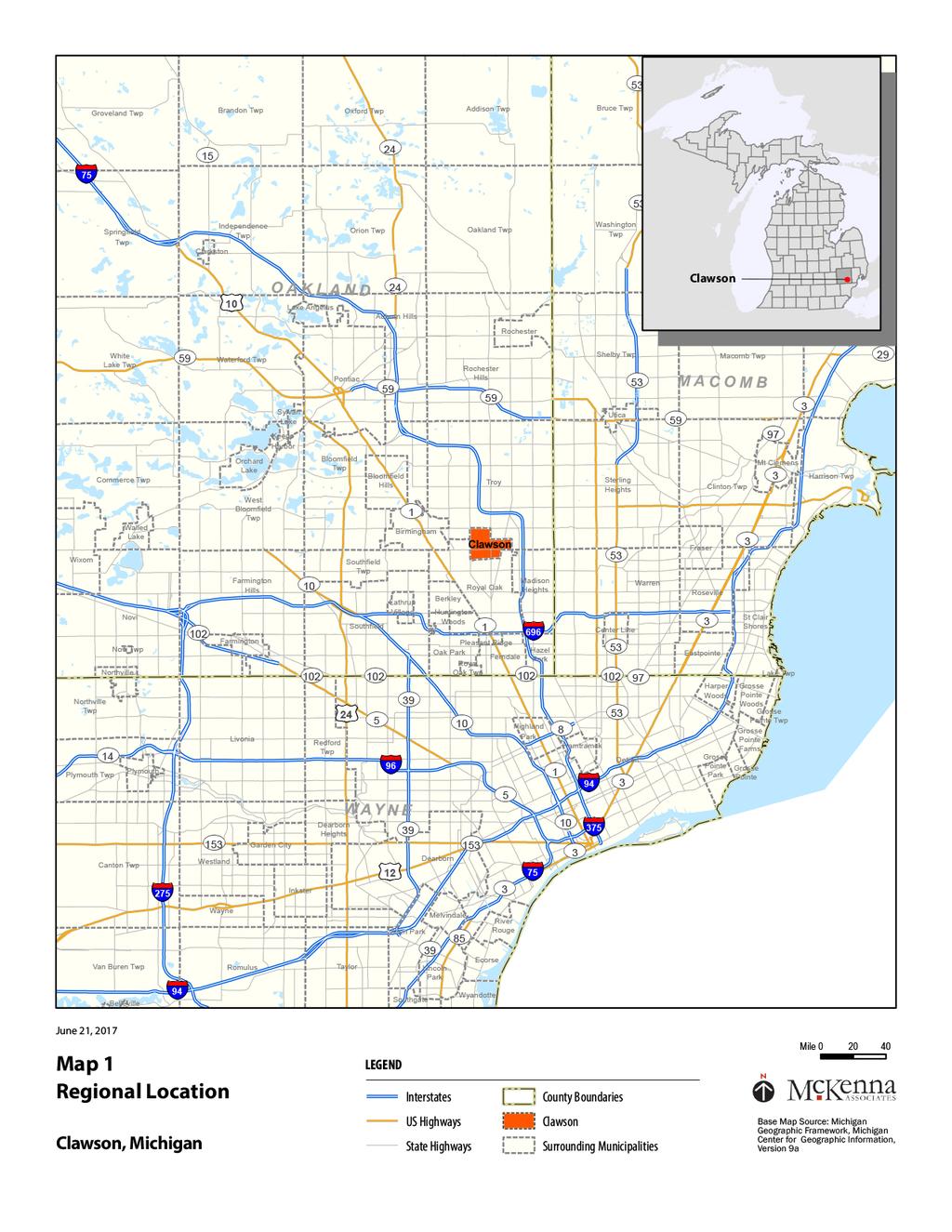
14 REGIONAL SETTING The City of Clawson is located in the southeast quadrant of Oakland County about one mile west of the Interstate 75 expressway. The community is 2.4 square miles in area and is bounded by the cities of Madison Heights, Royal Oak and Troy. Clawson is a second ring, established suburb centered in a highly populated and prosperous area of Oakland County (See Map 1). Since incorporation as a home rule city in 1940, the City has been fully developed, such that change will come from reuse and redevelopment opportunities. Clawson is best described as a community of neighbors that offers a friendly, small-town atmosphere where all amenities are, potentially, within walking distance. Residents enjoy easy access to community s facilities and amenities, such as the library, community center, historical museum, shops, parks, and schools. Clawson features a number of small town amenities, including affordable housing, a variety of downtown shops and restaurants, a stable government, high quality community services, and volunteer participation in community programs, while maintaining desirable access to state and interstate road networks as well as job centers in the Detroit metropolitan area. Clawson has received recognition as a Tree City USA and features reasonably-priced homes in a range of architectural styles. The school district demonstrates leading and learning with higher test scores and smaller class sizes. In 2016, Clawson was recognized as a MDHHS Community for a Lifetime, for its aging-friendly character, and in 2017 Clawson was ranked #20 as the 2017 Best Place to Raise a Family in Michigan from wallethub.com. The website s data team compared the 104 most populous cities in Michigan based on 21 key indicators of family-friendliness. 2 MARCH 13, 2018

15

16 HISTORICAL DEVELOPMENT The area now known as Clawson was first established in the 1820s when settlers purchased land identified as sections 3 and 4 of Town 1 North, Range 11 East; Royal Oak Township, and sections 33 and 34 of Town 2 North, Range 11 East; Troy Township. By 1827, the area that is now Clawson was known as Troy Township. Troy Township encompassed the area from 8 Mile Road (Baseline) to South Boulevard and from Dequindre to Greenfield (in Royal Oak) and Adams (in Troy). In 1832, the area south of Townline Road (14 Mile) became Royal Oak Township. The community remained in Troy and Royal Oak Townships until the Village of Clawson incorporated in During the first 100 years after settlement, farming was the primary industry. Small businesses and industry, including two (2) sawmills, began to arrive in Clawson in the 1830s with the construction of roads. The first road, now known as Main Street, was built in In 1829, Paint Creek Trail, now Rochester Road, was made a plank toll road from an existing Indian trail. Townline Road, later known as Clawson Road, and now known as 14 Mile, was finished in The first post office was opened on August 16, 1880 and was named Clawson. Although accounts vary on the origin of this name, with the post office, the area became known as Clawson. After the Interurban Railway was built through Clawson in 1899, developers began to subdivide Clawson. The railroad gave Clawson access to other communities and residents the opportunity to work in Detroit but live where lots were cheap. 4 MARCH 13, 2018

17 In 1940, Clawson incorporated as a home rule city and really began to grow. By 1949, 500 new homes were built, and there were also new factories, new commercial buildings, and a weekly newspaper. In the 1950 s and 1960 s additional homes, commercial buildings, schools, churches, and municipal buildings were built. The City s downtown surrounds the intersection of Main Street and 14 Mile Road. A Downtown Development Authority (DDA) was established in 1977 with the intent of halting property value deterioration and promoting economic growth of the downtown. After several years of limited activity, a Tax Increment Financing Plan (TIF) was completed in The TIF and an ISTEA grant enabled the DDA to plan and implement streetscape improvements that were installed in After the streetscape was completed, the DDA went dormant to reduce expenses and in hopes that private investment would spur growth in the downtown. In 2002, the DDA was reconstituted. In recent years, the downtown has experienced significant private investment in the restoration of vintage style buildings, new specialty retail stores, and unique restaurants/taverns. To this date, there exists a continuing interest in the community of the development of the downtown area. In 2017, Clawson has a reputation as one of the most pleasant places to live and work in Southeast Michigan. Numerous businesses call the City home, and economic activity abounds along the commercial corridors of 14 Mile Road, Main Street, Crooks Road, Maple Road, and Rochester Road. This year the City s Housing Market was listed as the 10th healthiest in the nation in SmartAsset.com s Healthiest Housing Markets Study. The City s walkability and sense of community make it true to its motto, The Little City with a Big Heart! 2017 MASTER PLAN CITY OF CLAWSON, MI 5

18 BASIS FOR THE MASTER PLAN AND PURPOSE The Michigan Planning Enabling Act, Public Act 33 of 2008, as amended, provides, among other things, the authority for Michigan municipalities to prepare and adopt a master plan. It further provides for a master plan to be reviewed every five years. The Michigan Zoning Enabling Act, Public Act 110 of 2006, as amended, provides for zoning to be based on a plan. This master plan, and the City s related planning documents, constitute that plan. The City of Clawson 2017 Master Plan presents the City s vision for its future. It serves as a policy guide for the community, and informs the decisions of City officials and administrators, governmental agencies, organizations, and private individuals. It is designed to provide a flexible roadmap for future development, redevelopment, and land use, and to ensure that such activities are pursued in a manner that is consistent with the community s goals and objectives. The recommendations presented in the text and shown graphically form the basis for the City s zoning regulations and various other land use controls. This plan is long range in that it examines past trends and makes projections for the next five to twenty years. This allows the City to plan ahead and anticipate future needs. It should be noted, however, that projections are most accurate in the short term, and many factors that will shape the future cannot be anticipated. For this reason, not less than every five years, the plan needs to be reviewed to determine if amendments are needed or a new plan should be undertaken. 6 MARCH 13, 2018

19 2 COMMUNITY PROFILE DEMOGRAPHICS A key element to planning a community s future land use and community facilities needs is an analysis of its demographic characteristics. This section includes discussions of trends in population characteristics, age structure and composition, and household composition, and their impacts on the City s demographics. The data and trends identified in the analysis of each factor provides a base from which to develop strategies to address the needs of Clawson s residents MASTER PLAN CITY OF CLAWSON, MI 7
20 POPULATION The City of Clawson experienced a significant population boom from 1950 to In two decades, the population increased 239 percent. This spike was a common occurrence throughout the nation, as it reflects the Baby Boomer period after the end of World War II. However, since the 1970 s, Clawson has experienced a steady decline in population, decreasing an average 9.3 percent each decade. That trend has now reversed slightly, with the 2015 population of the City estimated to be 12,015 by the American Community Survey. The Southeastern Michigan Council of Governments (SEMCOG) predicts that by the year 2040, the City of Clawson can expect to have a population of 12,373 (see Figure 1). The incremental increase in population is not enough to warrant significant housing and infrastructure plans, but it does suggest that Clawson has a stable population. Further, it suggests that planning and development efforts have been successful in appealing to new and existing residents. Figure 1: Clawson Population Growth ( ) The pattern of population decline noted in Clawson is parallel to that of surrounding communities in southeast Michigan. However, during this same period, Oakland County grew from 1,083,592 to 1,202,362 in total population, an 11.0 percent increase. Between 2010 and 2040 all communities shown in Figure 2 are expected to experience increases in total population. Each community is expected to increase to or surpass year 2000 population levels, suggesting that these areas are rebounding after the economic decline and fallout of the Great Recession. SEMCOG predicts that each community will increase or stay at relatively the same levels through Oakland County is expected to incrementally increase in population between 2010 and 2040, by approximately 3.7 percent or 44,501 new residents. 8 MARCH 13, 2018
21 Figure 2: Total Population in Clawson and Surrounding Communities ( ) HOUSEHOLDS According to the 2014 American Community Survey, the City of Clawson has 5,417 households. As Table 1 indicates, the household size in Clawson increased by 1.9 percent from 2010 to After several decades of decline, Clawson and several surrounding communities are experiencing an increase in household size. According to the 2010 Census, the City of Clawson has 5,460 households. As Table 1 indicates, the household size in Clawson was 2.14 persons per household in 2010, and is projected to be 2.32 persons per household in The table also shows that since the 1970 s, household size has decreased in Clawson, adjacent communities, and Oakland County. However, similar to population trends in these areas, household size is predicted to increase by The changes in family dynamics are reflected in the historical decline of household size. In 2015, household size was estimated at 2.16 persons per household by the ACS MASTER PLAN CITY OF CLAWSON, MI 9
22 Table 1: Household Size in Clawson and Surrounding Communities ( ) Community Clawson Berkley Ferndale Madison Heights Royal Oak Troy Oakland County HOUSEHOLD TYPE According to the 2014 ACS, 52.7 percent of the City s population lives in family households. This percentage is less than the County as a whole, which is 65.3 percent. The remainder of the population is composed of non-family households. Non-family households are those that comprise a group of unrelated persons or one person living alone. Of all housing units, 69.2 percent were owner-occupied in AGE COMPOSITION As depicted in Figure 3, 43.5 percent of residents in Clawson are between ages 35 and 64. Approximately 15 percent are over the age of 65 and the remaining 41 percent are below the age of 35. By 2040 the age distribution in Clawson is projected to change significantly in the 65+ range. By 2040, approximately 25 percent of residents will be ages 65 and older, 35 percent will be between the ages of 35-64, 29 percent will be between the ages of 18-34, and 18 percent will be between the ages of In other words, relatively larger percentages of residents will be in an age range that would tend to be in one or two person households, i.e. those approaching or beyond child-rearing. Figure 3: Population Distribution by Age Group (2014) 10 MARCH 13, 2018
23 Figure 4: Population Distribution by Age Group (2040) INCOME The City of Clawson has experienced a decrease in affluence over the past two decades. The median household income in 2010 was $60,300 and $54,900 in 2014 (2016 dollars). The household income decrease is due to the national economic crisis in which the unemployment rate rose to 8.0 percent in Clawson in 2014; a dramatic increase from 1.6 percent unemployment in In 2014, 5.5 percent of families were living below the poverty rate. EDUCATION The City s population is well-educated. According to US Census, over 65 percent of Clawson residents over 25 years of age have college or advanced education. LAND USE IMPLICATIONS Decreasing population directly relates to the reduced number of persons per household. This has been the trend in Clawson, though SEMCOG projections indicate that there may be a slight increase in the number of persons per household in the future. To maintain a stable population, it is likely that the City will need to add housing units. By 2040, there will be an increase in average household size and persons under the age of 17. In the future, relatively larger percentages of residents will be in an age range that would tend to be in one or two person households, i.e. those approaching or beyond child-rearing. The changing population distribution and household size is likely to lead to a demand in a greater variety of housing types for Clawson s residents MASTER PLAN CITY OF CLAWSON, MI 11

24 HOUSING CHARACTERISTICS There are 5,729 housing units in the City of Clawson in 2014; a 1.1 percent decrease from the 5,791 units reported in There were 5,791 housing units in the City of Clawson in 2010; a 2.0 percent increase over the 5,676 units reported in As per Figure 5, the City of Clawson has issued 137 new residential building permits, including one (1) apartment building (44 units) since The issuing of permits for new residential housing has typically amounted to only a handful each year, as one would expect from a built-out city, and some years saw no new development. Nonetheless, new home construction after the Great Recession is markedly less than it was before it. Figure 5: Residential Building Permits, MARCH 13, 2018
 are single-family detached dwellings, 191 (3.3 percent) are single-family attached dwellings, 1,087 (18.8 percent) are apartments, and 49 (.08 percent) are two-family dwellings or duplexes.")


25 HOUSING UNIT TYPE The predominant housing type in the City of Clawson is an owneroccupied, single-family home. Of the 5,791 total housing units, 4,452 (76.9 percent) are single-family detached dwellings, 191 (3.3 percent) are single-family attached dwellings, 1,087 (18.8 percent) are apartments, and 49 (.08 percent) are two-family dwellings or duplexes. Approximately 69 percent of the dwelling units in Clawson were owner-occupied in Just under 5% of housing units were vacant, with the balance being rented. The percentage of owner occupied housing units has remained relatively unchanged in recent years, in spite of pressures on home ownership that were created by the Great Recession. However, the renter-occupied and vacancy rates have increased. This is due to the economic hardships felt throughout the region. AGE OF HOUSING STOCK As depicted in Table 2, the majority of the housing stock in the City of Clawson was built before The aging housing stock can bring a sense of character and charm to the community; however, it is necessary for those homes to be managed and maintained. Table 2: Age of Clawson s Housing Stock Year Structure Built Number Percent Built 2010 or Later 6 0.1% Built 2000 to % Built 1990 to % Built 1980 to % Built 1970 to % Built 1960 to , % Built 1950 to , % Built 1940 to % Built 1939 or earlier % 2017 MASTER PLAN CITY OF CLAWSON, MI 13
26 MEDIAN HOME VALUE Home values in Clawson average $100,000 to $200,000 in Median home value is $179,847 (2016 dollars). This is comparable to surrounding communities with housing stock of similar age. The City s Housing Market was listed as the 10 th healthiest in the nation in SmartAsset.com s Healthiest Housing Markets Study. Figure 6: Median Home Value 2010 Figure 7: Home Value MARCH 13, 2018
27 LAND USE IMPLICATIONS Residential building activity has decreased significantly since the end of the 2006 construction season. Because the City adopted large lot zoning regulations that serve to limit the number of new lots that can be created, new residential building activity will mostly occur through the demolition of an existing structure. The City is experiencing design inconsistencies between newly constructed homes and the neighborhoods into which they are being inserted. The housing stock is older (most constructed prior to 1969), which results in some functional obsolescence. Housing value is comparable to neighboring communities, but the velocity of the housing market is likely to lead to increasing home prices that will, at a certain point, put smaller, existing houses at risk of becoming teardowns. EXISTING LAND USE A major part of a community master plan is to identify existing land use patterns. This task not only identifies the locations of particular land use activities, but it highlights the areas with future growth potential and areas where land use conflicts exist. The City s existing land uses were field verified in September 2016 and this information was used for decisions on future land uses and development potential. The existing land uses are illustrated on Map 2 by the delineation of the following land use categories. Based upon that map the following development patterns were observed: Single Family Residential: This classification includes parcels having one-family detached dwelling units. Over 70 percent of Clawson s total land area is covered by single-family dwelling structures and uses. Multiple Family Residential: At 5.10 percent, Multiple Family Residential includes land areas that are occupied by predominately residential structures containing dwelling units for two or more households. The multiple family residential use category now includes two family residential, which were considered independently in the 2009 Master Plan. Office / Services: At 2.10 percent, Office / Services land use has increased since the previous Master Plan. Located on major thoroughfares, office and services land use are intended to serve Clawson residents and those in nearby communities. Commercial / Business: Commercial Business uses are located throughout the City, along the major roadways. Parcel sizes tend to vary throughout Clawson, with the larger parcels located outside of the Central Business District. These uses tend to include chain retails or strip malls, as they require larger parcels to accommodate larger establishments and private parking. Central Business: Land uses within the Central Business District are located in Downtown Clawson, at the intersection of 14 Mile Road and Main Street. These parcels are small in size and are locally owned businesses that service the community. Streetscape and façade design regulations are vital to the Central Business District. Revitalization efforts have been focused on Downtown Clawson in the past few years to redevelop as a walkable and pedestrian friendly community. Quasi-Public: Quasi-Public land uses include churches, private clubs and schools. Since the previous Master Plan, land use within this category has increased by one percent throughout Clawson. Public: Public land uses have remained relatively the same since These uses include municipal purposes and schools. Recreation: Just over three percent of Clawson s land use is designated for Recreation purposes. Expansion, development, and updates are detailed in the 2017 Parks and Recreation Master Plan MASTER PLAN CITY OF CLAWSON, MI 15


28 Industrial: Industrial land uses are scattered in pockets along Rochester Road, 14 Mile Road and Crooks Road. The total land area has decreased minimally since the previous Master Plan. Most of the parcels classified as Industrial are the larger properties within the City. Public Parking: Vehicular parking is generally provided by surface lots. Besides on-street parking, the majority of public, surface parking in the City is within its City Center District. Currently, 12.2 percent of the land within the City that is zoned City Center is used for surface public parking. Vacant: There is considerable less acreage designated as vacant parcels within the City; currently less than one percent. The properties are generally well maintained by the owners. 16 MARCH 13, 2018

29
30
31 Table 3 provides an analysis of land use acreage and percent of total area of the City. To ensure that the current inventory can be compared to the previously adopted Master Plan, the same land classifications were employed. Since the previous Master Plan, land use patterns have remained relatively stable, with slight changes as the result of development or more accurate measurement techniques. Table 3: Clawson Existing Land Use Existing Land Use Acreage Percent of Total Area Single Family Residential % Multiple Family Residential % Office / Services % Commercial % Central Business District % Quasi-Public % Public % Recreation % Industrial % Public Parking % Vacant % Total 1, % LAND USE IMPLICATIONS There has been a substantial decrease in vacant land remaining in the City. Many of those that remain are the result of land speculation. The City has focused efforts to ensure that vacant parcels are maintained by its owners so as to prevent blighted, overgrown properties, but the City should look for other means to address the unproductive use of prime real estate. Redevelopment of commercial sites within the City is of critical importance to community appearance and quality of life. Main Street and 14 Mile Road are the main commercial corridors through the City, with Rochester Road, Crooks Road, and, to a lesser degree Maple Road, providing additional commercial properties. The designation for Multiple Family Residential has remained stable since the 2009 Master Plan. However, recent national trends indicate that young professionals are interested in housing options outside of the traditional single-family home. Attracting young professionals to reside in Clawson will likely include expanding the housing options to include apartments within walkable districts, flats, and townhouses. In order to keep single-family areas intact, such new housing options will typically be appropriate when located along main thoroughfares, within mixed-use districts. The foregoing notwithstanding, there is a large module of underutilized land to the south of the Clawson Center shopping plaza (within the Westgate District), which would be appropriate for additional, multiplefamily housing MASTER PLAN CITY OF CLAWSON, MI 19

32 COMMUNITY FACILITIES Map 3 illustrates the location of the major community facilities within the City of Clawson. A description of existing facilities is provided below. 20 MARCH 13, 2018
33
34

.")
35 CITY HALL AND MUNICIPAL BUILDINGS City Hall, built in 1963, occupies a 1.4-acre site located on the west side of Main Street, two blocks north of 14 Mile Road. The building contains the general City offices, council chambers, and police department. Located across Main Street from City Hall is Blair Memorial Library and Clawson Historical Museum. The City owns and maintains the Hunter Community Center that contains the Parks and Recreation Department offices and is used for adult education courses and other community activities. PARKS AND RECREATION Within Clawson s boundaries is 45.8 acres of park land that is owned and maintained by the City. The largest park is City Park (36.9 acres). There, families and friends can enjoy lighted recreation facilities for active sports, such as, football, basketball and tennis. There is also open green spaces for picnicking and other leisure activities. The City of Clawson City Hall, City Park, Hunter Park, Parkland Park, Grant Park, Baker Park and Memorial Park comprise the City of Clawson parks facilities. There are also indoor and outdoor recreational facilities located at Kenwood and Schalm elementary schools, Clawson Middle School, and Clawson High School. Clawson City Council adopted the Parks and Recreation Master Plan in SCHOOLS The Clawson Public School District serves more than 1,800 students and includes four (4) schools: Schalm Elementary serves K-5 grade students living north of 14 Mile Road and west of Rochester Road Kenwood Elementary serves K-5 grade students living south of 14 Mile Road and east of Rochester Road Clawson Middle School Clawson High School There is one (1) private elementary school within the City. Guardian Angels Catholic School serves kindergarten through eighth grade. Guardian Angels school is located on 14 Mile Road, west of Rochester Road and east of downtown MASTER PLAN CITY OF CLAWSON, MI 23
36 POST OFFICE The local U.S. Post Office is located on North Main Street, south of City Hall. WATER SERVICE The City of Clawson owns and maintains the municipal water system that services the entire City. Clawson purchases its water from the Southeastern Oakland County Water Authority (SOCWA) at three locations. SOCWA provides Detroit water through its member distribution systems to a population of 210,000 within a 56-square mile area. Current members are: Berkley, Beverly Hills, Bingham Farms, Birmingham, Clawson, Huntington Woods, Lathrup Village, Pleasant Ridge, Royal Oak, Southfield and Southfield Township, Bloomfield Hills, and Bloomfield Township. SANITARY AND STORM SEWERS The City of Clawson owns and maintains the local combined sanitary and storm sewer system that discharges at various points into sewers owned and maintained by the Oakland County Water Resources Commission (OCWRC). SOLID WASTE The City of Clawson contracts a private company for trash collection and removal. Clawson is a member of the Southeastern Oakland County Resource Recovery Authority (SOCRRA), a municipal corporation founded in the early 1950 s. The City also provides an extensive recycling program for residents and curbside yard waste collection during compost season (April December). OTHER UTILITIES Within Clawson, electric power is provided by DTE Energy, telephone service is provided by AT&T, and natural gas is provided by Consumers Energy. Several cable television and internet service providers exist within the community, including Wireless Oakland. LAND USE IMPLICATIONS The City provides approximately 167 square feet of park land per resident (based upon the 2014 American Community Survey). Public schools are within walking distance for many of the school age children within the City. Municipal water and sewer are available to all residents and businesses within the City, although its age has resulted in the need to continually update the system. Given the inherent limitations of the City s combined sewer system, efforts should be made to eliminate impervious surfaces wherever possible and new development should not result in an increased rate of storm water discharge. Likewise, landscaping with the potential to absorb and utilize storm water should be encouraged. 24 MARCH 13, 2018

37 3 TRANSPORTATION The City of Clawson was settled according to the grid established by the American Rectangular Land Survey System of Clawson s road network generally follows the grid pattern established by this land survey system, except where topography has required otherwise MASTER PLAN CITY OF CLAWSON, MI 25
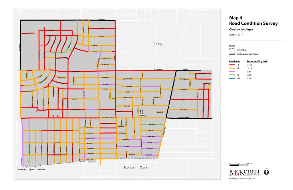
38 ROADWAY CLASSIFICATION AND RESPONSIBILITY Administrative jurisdictions identify roads in terms of governmental responsibility for construction and maintenance. Road classifications are also used to determine eligibility for federal aid. ADMINISTRATIVE JURISDICTION / FEDERAL AID Act 51 of the Public Acts of 1951, as amended, charges county road commissions with the responsibility of classifying county primary and local roads. Roads designated as primary roads must be of the greatest importance. This determination is based on traffic volumes, primary generator of traffic served and other factors. The Road Commission for Oakland County (RCOC) has administrative jurisdiction over the following County primary roads within the City of Clawson: Maple Road, Crooks Road north of 14 Mile, Rochester Road north of 14 Mile and 14 Mile east of Rochester Road. The remaining streets in the City of Clawson are under the jurisdiction of the City of Clawson. Map 4 depicts the current road conditions in the City. FUNCTIONAL CLASSIFICATION Functional classifications are used to group streets and highways into classes, or systems, according to the character of traffic service they are intended to provide. There are three (3) highway functional classifications: Arterial: Provides the highest level of service at the greatest speed with the longest uninterrupted distance, with some degrees of access control. Collector: Provides a less highly developed level of service at a lower speed for shorter distances by collecting traffic from local roads and connecting them with arterials. Local: Consists of all roads not defined as arterials or collectors; primarily provides access to land with little or no through movement. The majority of streets within the City of Clawson are classified as urban local streets. Portions of Maple, Crooks, Rochester, and 14 Mile Roads are classified as urban principal arterials/county primary roads. Main Street and a portion of 14 Mile Road and Crooks Road are designated as an urban minor arterial and Normandy Road is designated as an urban collector. Map 5, the existing transportation network, illustrates the classifications for roadways within the City of Clawson. 26 MARCH 13, 2018
39
40
41
42


43 PEDESTRIAN CROSSINGS 14 MILE ROAD In 2014, the City of Clawson received a grant from MDOT to construct three median islands on 14 Mile Road in the downtown district to help pedestrians cross the busy roadway. The three islands are uniquely designed to protect pedestrians and bicyclists while making drivers more vigilant as they enter Downtown Clawson. The raised median islands with marked crosswalks, flashing lights and crossing beacon is intended to provide safe access for shoppers and visitors, as well as to reduce the potential for vehicular and pedestrian accidents. Additionally, the pedestrian crossings are meant to have a positive effect on economic development in Downtown Clawson, as the investment has both functional and aesthetic benefits. The mid-block pedestrian crossings on 14 Mile Road have received mixed reviews, based on community feedback. Those that were in favor of the islands had first-hand knowledge and experience with the crossings and found that drivers were considerate and obeyed the flashing beacons. Several users were residents from Clawson Towers and used the medians to cross the main roadway without having to walk to the main intersection, which may be a cumbersome venture for many. Others found the pedestrian crossings to be confusing, as the beacons are activated when prompted and each of the three have differing designs, or generally felt unsafe utilizing them. ROCHESTER ROAD Rochester Road is comparable to 14 Mile Road, in terms of the rate of vehicular traffic on the roadway each day. According to SEMCOG, the Average Annual Daily Traffic (AADT) count along Rochester Road, 14 Mile Road to Maple was 12,410 vehicles (2010). Fourteen Mile Road west of Rochester Road had 13,310 vehicles (2015) on its roadways per day, and 14 Mile Road east of Crooks had 11,583 (2012) per day. These city highways can pose dangers to pedestrians and bicyclists. Midblock crossings contributed to the redevelopment and revitalization of Downtown Clawson and they might do the same for the Rochester Road corridor. Installing designated pedestrian crossings would further encourage a cohesive corridor design throughout the community. Raised median pedestrian crossings, like those installed on 14 Mile Road, would not be prudent on Rochester Road without the presence of a center turn lane; however, it is possible to install designated pedestrian crossings with painted or bricked crosswalks with flashing beacons that would achieve similar results MASTER PLAN CITY OF CLAWSON, MI 31


44 There are several benefits to installing pedestrian crossings on Rochester Road north of 14 Mile Road including: Encourage a cohesive community roadway design Develop a pedestrian and bicyclist friendly environment Traffic-calming efforts to reduce vehicular crashes Encourage streetscape design efforts to revitalize the corridor Redirect and focus economic development efforts along the roadway Create a sense of place through public art crossing design Public input revealed that people generally feel like Rochester Road is not an integral part of Clawson, and encouraging pedestrian linkage here could help rectify that. SOUTH MAIN STREET South of 14 Mile Road, Main Street currently presents a significant obstacle to pedestrian activity. This is particularly concerning given the number of dining options on either side of that stretch of road and the issue it creates for the connectedness of the neighborhoods on either side. In the future, additional, signalized crossings should be considered. Likewise, on-street parking should be extended further south in this area, both to provide additional parking options for those wanting to park and enjoy what this area of the City has to offer and to encourage slower traffic movement through the area. A uniform pattern of street tree planting in this area will also promote these goals. PARKING Parking availability has become a popular discussion point in the City of Clawson. Parking pressures from downtown can have an effect on nearby neighborhoods. In order to create vibrant, pedestrian corridors that can be utilized by visitors to the City and residents who do not happen to reside nearby, there need to be convenient parking options to serve those areas as part of a range of motorized, public, and non-motorized options for accessing the City s businesses and amenities. At the same time, unnecessary pavement is not desirable, and the City should review its current parking regulations and address alternative means for calculating standards appropriate for each use. Shared parking, in lieu parking fees, more on-street parking, and low impact design techniques (LID) should all be considered. PUBLIC TRANSIT The Suburban Mobility Authority for Regional Transit (SMART) currently provides fixed route bus service along Main Street and 14 Mile Road in Clawson. Other services provided by SMART include Connector Service and Community Transit to the Clawson Senior Center (both are available by advanced reservation). Seniors participating in our roundtable discussion valued SMART S services very highly. Conversely, high school students surveyed generally had never utilized a SMART bus, pointing to a disconnect in service delivery to younger residents and those with other transportation options. The City should encourage programs and practices that advance awareness of public transit options. 32 MARCH 13, 2018

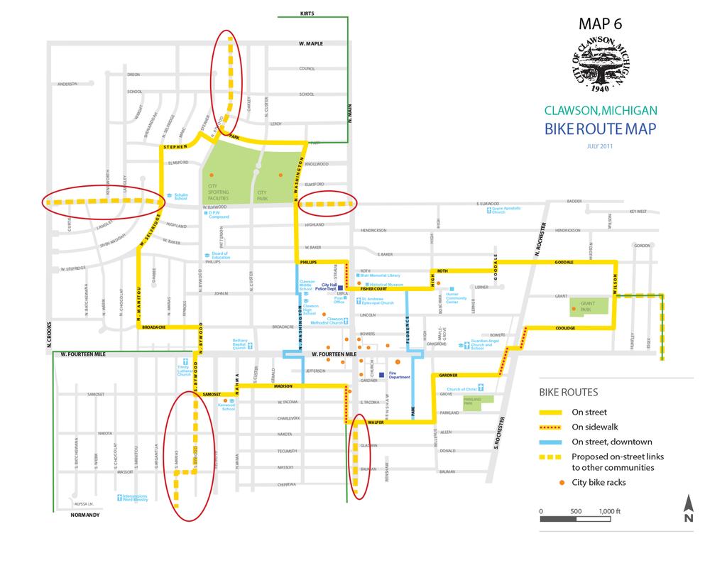
45 NON-MOTORIZED TRANSPORTATION A system of bike routes is currently designated within the City of Clawson and is being revised to link the existing route with neighboring Troy and Royal Oak. As shown in Map 6, the areas circled in red are going to be removed from the existing plans and the areas highlighted in green are how the City is going to link with Troy and Royal Oak In Troy, at Kirts and Main/Livernois, additional signage would be added to continue Troy s route south along Main/Livernois on the west sidewalk to Park Drive, then west along Park Drive where it would join the existing bike route at Park Drive and Washington. In Royal Oak, the route will be linked in three different locations. Currently Royal Oak's bike route goes north on Crooks from Normandy and ends at West 14 Mile Road. Changes in signage are planned and continuing the bike route east along West 14 Mile to join the existing bike route at Bywood. Royal Oak's bike route also ends at East 14 Mile Road and Campbell in Madison Heights. Changes in signage to continue the bike route north across East 14 Mile Road and onto Sheffield in Troy. From there, the bike route would continue north to Grant, then west along Grant to join the existing route at Grant and Wilson. Signage is also planned at Normandy and South Main to continue Royal Oak's Bike route north, on the sidewalk along South Main, to join the existing bike route at Charlevoix/Walper and South Main. The City of Clawson's bike route is a unidirectional route that goes in a counter clockwise circle and Royal Oak and Troy's are bi-directional routes. Additional signage is planned to correct this and make the City of Clawson's bike route bi-directional. Residents surveyed did not express much support for on-street bike routes. The implications of this are discussed in the City s Complete Streets Policy, below MASTER PLAN CITY OF CLAWSON, MI 33
46
47
48
49 4 COMPLETE STREETS Complete Streets is a comprehensive transportation policy and design approach that requires all streets to be designed, planned, constructed, and operated with all users considered regardless of their ages and abilities and for all modes of transit. Complete Streets enables safe, convenient and comfortable travel and access for those walking, biking, driving cars, driving delivery vehicles, or riding public transit. Complete Streets includes: 1) pedestrian infrastructure including sidewalks, curb-cuts, bump-outs, improved cross-walks, and ADA compliant facilities; 2) traffic calming measures including shorter curb radii, center medians, angled face-out parking, and road diets; 3) bicycle facilities including protected bike lanes, shared-use paths, signage, bicycle parking facilities; and 4) public transit improvements MASTER PLAN CITY OF CLAWSON, MI 37
50 COMPLETE STREETS POLICY There is no single formula or prescription for a Complete Street in Clawson. Streets are complete when they fit in the context of the surrounding area. Not all city streets will include all of the elements below, but this list represents what Clawson will strive to achieve when evaluating future transportation projects. In 2010, Clawson City Council adopted a resolution in support of Complete Streets. Downtown Clawson has undergone significant transformation in the past decade to make the area more walkable and pedestrian friendly. However, the same emphasis for downtown development and design standards does not continue outside of the DDA, and the City should pursue enhancements citywide, based upon the principles that follow. Pedestrians: Clawson s streets will include sidewalks with unobstructed walking space, adequate lighting, benches, trees, shading, roadway separation and on-street parking, easy access to walkable destinations, and safe and frequent crossings. Bicyclists: Clawson s streets will include spaces to bike comfortably. Public engagement showed a marked preference for utilization of sidewalks for biking, and this appears to be what most people do. Legal barriers to doing so should be removed, and State law should guide (i.e. bicyclists may use sidewalks but must yield to pedestrians). In some cases, marked bike lanes, or the use of sharrows (pavement markings within a travel line alerting drivers to an area where bicycles may be riding), will be appropriate, especially where streets articulate with designated bike routes in neighboring communities. The City s Parks and Recreation Department has identified potential biking routes through the City, which represents one possible route around and to some City facilities. However, it is anticipated that many bicyclists will have the City s downtown core as a destination, and appropriate wayfinding techniques should be employed in the shorter term to assist bicyclists in getting there. In the longer terms, the City should consider implementing appropriate design changes to accommodate use of sidewalks and streets by bicyclists. Vehicles: Clawson s streets will be safe and convenient for driving. Signals will be timed to reduce congestion, on-street and off-street parking will be easily accessible and appropriately priced, and streets will be designed to promote safe driving speeds. Streets are places: Clawson s streets will be places. They will not simply link destinations; they will be destinations in themselves, and include places for social gathering, exercising, and relaxing. Street trees are encouraged to add to the sense of place, while also adding to the urban tree canopy that attracts future homebuyers. Adding value: Clawson s streets will enhance property value and be coordinated with land use development standards to support commerce though connectivity, design aesthetics, street life, and access. Transit: Clawson s streets will support access to existing and future transit systems in the region. Supporting Complete Streets in Clawson will complement existing development patterns, enhance the attractiveness and use of the City s business districts, complement traditional neighborhood development patterns, and further a more vibrant City life. PROTECTING VULNERABLE USERS It is generally recognized that traffic volumes on the major streets through Clawson are high. While higher traffic volumes are desirable for some businesses, excessive volumes and higher speeds cause downtowns and commercial corridors to become less attractive for users and investment. The City s street system should evolve to be a comfortable environment for all, not just those using a motor vehicle. 38 MARCH 13, 2018

51 5 ECONOMIC BASE Consideration of the local economic base is included in the planning process to ensure that land reserved for commercial and industrial uses is of adequate size to meet the aspirations of the community. However, new commercial and industrial uses must also be adequately served with public utilities, service and transportation systems. Factors considered in the evaluation of the local economy include labor force characteristics, existing employment within the City, and tax base MASTER PLAN CITY OF CLAWSON, MI 39
52 Figure 8: Labor Force Characteristics TAX BASE Real property assessments are broken into various use classifications and include residential, commercial and industrial development. Table 4 presents the 2016 distribution of assessed and equalized real and personal property values for Clawson and its surrounding cities. The comparison indicates that Clawson s assessed, equalized, and taxable values for real and personal property are in line with the community of Berkley, whose total population is the most comparable to that of Clawson. Table 4: Assessed and Equalized Property Values CITY REAL PROPERTY PERSONAL PROPERTY Assessed Equalized Taxable Assessed Equalized Taxable Clawson $411,994,470 $411,994,470 $319,038,200 $12,251,880 $12,251,880 $12,251,880 Berkley $621,798,340 $621,798,340 $496,694,610 $11,356,570 $11,356,570 $11,349,570 Ferndale $648,409,190 $648,409,190 $492,602,610 $41,945,910 $41,945,910 $41,945,910 Madison Heights $805,090,710 $805,090,710 $660,813,910 $102,531,420 $102,531,420 $102,506,120 Royal Oak $2,730,208,790 $2,730,208,790 $2,312,254,100 $123,603,040 $123,603,040 $123,548,190 Troy $5,244,907,820 $5,244,907,820 $4,158,063,320 $381,971,050 $381,971,050 $381,971, MARCH 13, 2018

53 6 RETAIL GAP ANALYSIS Clawson s downtown district has undergone a transformation and revitalization in the past decade, attracting the attention for business owners to open a local brewery, one-of-a-kind, high-end lifestyle store, and a plethora of dine-in restaurants. With national and local retail trends changing, Clawson must address what the future of its shopping districts will look like. This section will analyze the market for additional commercial space MASTER PLAN CITY OF CLAWSON, MI 41
54 For the purpose of this analysis, the center of the downtown district (intersection of 14 Mile and Main Street) is the point at which drive times have been measured. The two-minute drive radius includes all of the downtown district and its neighbors, however, we will not be focusing on the downtown district in this analysis. The retail market is analyzed in depth in the Downtown Master Plan, which was adopted in This section will analyze the market for additional commercial space in the City of Clawson by conducting a Gap Analysis. Gap Analysis compares the supply of a certain good or service within a community to the demand for that good or service, based on the spending power of residents. If the number is positive, that indicates pent-up demand for a new retail location. If the number is negative, that indicates an oversupply of a certain type of commercial business. Then, the gap is converted from a spending power amount (in dollars) to a number of additional square feet of retail space demanded (based on per-square-foot sales for each category of retail). Finally, the number of additional square feet will be compared to the average size of a store in each category to determine the number of new stores demanded. In considering the results of these retail gap calculations for purposes of the Master Plan, it is important that the numbers not be viewed as an absolute determinant of the community s future. Retail gap is only one aspect. Local variations in buying preference, buying power, community desires, and other local characteristics and assets will greatly impact the future and outcome. The purpose of this analysis is, therefore, to give some insights which can contribute to a balanced approach in future economic development efforts and to create realistic expectations for the types of new retail development the City can hope to attract. TRADE AREA Customers and potential customers for Clawson businesses come approximately from the three rings surrounding Clawson. For purposes of analysis, they are measured from the heart of downtown Clawson (14 Mile and Main Street). The first ring, within a two-minute drive, covers the entire downtown district and most of the City itself. The second ring, within a four-minute drive, captures the remainder of the City, as well as portions of several surrounding communities. Within the second ring, Clawson s retail centers compete with Royal Oak and Birmingham commercial corridors. The third ring, within a six-minute drive, extends to the larger commercial areas of nearby communities. Within the sixminute drive radius is Oakland Mall and the Troy Suburban Collection. The Somerset Collection is located just outside the six-minute drive, however, it is worth noting as it attracts shoppers and tourists throughout the metro Detroit area. The abundance of shopping establishments in the six-minute radius suggests that it would not be beneficial to compete with the larger malls for economic expansion in Clawson. It would be best to focus on the four-minute drive radius surrounding Clawson in order to attract new businesses. 42 MARCH 13, 2018
 2017 MASTER PLAN CITY OF CLAWSON, MI")
55 Map 7: Drive Times from Downtown Clawson (City of Clawson Retail Trade Area) 2017 MASTER PLAN CITY OF CLAWSON, MI 43
56 GAP ANALYSIS With the trade areas for the community established (in this case, approximately estimated as the six-minute drive around Downtown Clawson, with sub-areas at two and four minutes for more detailed analysis), a gap analysis can be performed. As noted above, a positive gap indicates that there is more demand than supply and that a new store may be necessary to fill a particular need. A negative gap indicates that there is more supply than demand, meaning either that existing stores may be in danger of going out of business or that additional demand is coming from outside the identified trade area. For the purposes of this analysis, the gap will be expressed as a percentage of demand i.e. the percentage of demand that is not being met by the existing supply. A negative percentage indicates a negative gap, i.e., a surplus of retail space in that category and no demand for additional stores of that type. Displaying the gap as a percentage allows a quick-glance analysis and easy comparison between categories. The gap can be used to project the demand for new stores in various retail categories. The gap will be divided by the average sales per square foot for each type of retail, and the resulting figure will be compared to the approximate size in square feet of an establishment that could open in Clawson. Because Clawson competes with other communities and several large-scale multi-story shopping malls, it will not be able to attract all of the new stores that are demanded within the trade area. The exact proportion of retail demand that will be absorbed in Clawson will be based on many factors, such as transportation improvements, land use policies, and economic development strategies. The six-minute drive time is the total demand base that Clawson can tap into as it grows in the future. Table 5 below shows the percentage gaps based upon the supply and demand within the trade areas. A positive gap (in green) means that there is unmet demand that could be filled by new businesses. A negative gap (in red) means the market is already oversupplied. 44 MARCH 13, 2018
57 Table 5: Percentage of Unmet Retail Demand Category Two Minute Drive Four Minute Drive Six Minute Drive Automobile Dealers 93.1% 35.5% -31.2% Other Motor Vehicle Dealers 100.0% 34.7% 41.1% Auto Parts Stores -0.1% -40.3% -19.2% Furniture Stores 51.2% 15.1% 2.2% Home Furnishings Stores % % -81.4% Electronics and Appliance Stores 87.7% -18.2% -61.0% Building Material and Supplies Dealers % 9.1% 13.8% Lawn and Garden Equipment Stores 100.0% 61.0% -24.6% Grocery Stores 78.2% 46.5% -81.3% Specialty Food Stores % -20.7% -0.5% Beer, Wine and Liquor Stores -4.3% 66.5% 37.8% Health and Personal Care Stores -82.1% -95.0% % Gas Stations 12.8% 31.2% -6.8% Clothing Stores 37.3% -85.9% -88.2% Shoe Stores -8.2% % -87.9% Jewelry or Luggage Stores 53.9% -78.4% -77.0% Sporting Goods, Hobby, Music Stores -3.4% 52.6% 28.9% Book Stores 22.3% 63.5% 67.1% Department Stores 100.0% 51.8% -3.4% General Merchandise Store 52.7% 65.3% 68.5% Florists % -68.6% -78.6% Office Supplies % % % Used Merchandise Stores 27.8% 69.6% 41.2% Full-Service Restaurants % -23.2% -34.5% Fast Food Restaurants -88.3% -50.1% -45.5% Bars -83.7% 55.1% 63.7% 2017 MASTER PLAN CITY OF CLAWSON, MI 45
58 Table 6 below shows the gap converted to a demand for additional stores, based on the size of the potential market and the usual square footage of stores in the category. The number of stores is presented as a range. Table 6: Demand for New Stores Category Two Minute Drive Four Minute Drive Six Minute Drive Automobile Dealers Other Motor Vehicle Dealers Auto Parts Stores Furniture Stores Home Furnishings Stores Electronics and Appliance Stores Building Material and Supplies Dealers Lawn and Garden Equipment Stores Grocery Stores Specialty Food Stores Beer, Wine and Liquor Stores Health and Personal Care Stores Gas Stations Clothing Stores Shoe Stores Jewelry or Luggage Stores Sporting Goods, Hobby, Music Stores Book Stores Department Stores General Merchandise Store Florists Office Supplies Used Merchandise Stores Full-Service Restaurants Fast Food Restaurants Bars MARCH 13, 2018

59 RETAIL TYPOLOGIES Clawson has successful examples of two of the three major retail typologies: indoor mall, suburban strip/big box, and walkable urban. There are several suburban strip malls on the main roads in Clawson, and the downtown district has undergone recent revitalization for a walkable environment. The City does not contain an indoor mall, however, Oakland Mall and the Somerset Collection are located 2.1 miles to the east and 4.1 miles to the northwest, respectively. Table 7 below shows the retail typologies generally favored by the retail types that show demand within the trade area. Of the retail types with unmet demand, all would be comfortable in a suburban strip setting. Very few, however, would commonly locate in an indoor mall. Retail types usually found in malls (clothing stores, shoe stores, etc.) are saturated in Oakland County. Table 7: Retail Typologies Favored by Businesses with Unmet Demand Retail Typology Suburban Strip/ Big Box Indoor Mall Walkable Urban Automobile Dealers X Grocery Stores X X Beer, Wine and Liquor Stores X X Gas Stations Sporting goods, Hobby, Music Stores X X Book Stores X X Department Stores X X General Merchandise Stores X X Used Merchandise Stores X Bars X X 2017 MASTER PLAN CITY OF CLAWSON, MI 47
60 CONCLUSIONS The following conclusions can be drawn from the data regarding retail demand in Clawson. There is demand within Clawson and its immediate surroundings for department stores, but the market is saturated within a six-mile drive. The Oakland Mall is located within a five-minute drive of downtown Clawson, and would satisfy most community residents. The Oakland Mall is located in an area with several suburban strip malls that will draw Clawson residents. All retail types that are associated with automotive sales or repairs have saturated markets in Troy, the northern neighbor of Clawson. Located northwest of Clawson on Maple Road is the Troy Motor Mall, a plethora of automotive dealerships and other motor vehicle dealers. Planning for the large amount of space needed for car dealerships should not be a priority of Clawson, as the City would not likely detract residents from frequenting the dealerships in which they have established relationships. There is a significant demand for general merchandise stores in Clawson and its immediate surroundings. General merchandise stores refer to a wide array of products, but it mainly pertains to stores that do not sell grocery items or alcohol. Frequently, these stores are satisfied as dollar stores. While these establishments are not exclusive to lower-income areas, care should be given as to whether to cater to this category of retail. Clawson is in a particularly difficult position in regards to retail supply and demand. The City is centrally located among several popular and established cities, such as Royal Oak, Birmingham and Troy. However, in this case being neighbors with several shopping centers and indoor malls does not leave Clawson with retail demand in which to draw residents and other shoppers. Commercial districts should provide for a flexible mixture of uses, to allow the available land to be used as the market demands. 48 MARCH 13, 2018

61 7 PUBLIC PARTICIPATION During the creation of this Master Plan, it was vital to engage the public in order to understand the strengths, weaknesses, and goals of the community. To create a framework for public participation, a goal and priorities survey of the Planning Commission, four roundtable discussions, and a public online survey were conducted to help identify issues and opportunities that are important in order to facilitate positive change MASTER PLAN CITY OF CLAWSON, MI 49
62 GOAL PRIORITIES SURVEY At the kick-off meeting between McKenna consultants and the Clawson Planning Commission, commissioners were asked to review goals and objectives relating to community facilities, economic development, neighborhoods, transportation, and downtown. The Goals Priority Survey was based on the goals and strategies from the 2009 Master Plan. For each objective, respondents were asked to rank the priority level for investment as High, Medium, or Low. It also allowed for respondents to articulate if the goals and strategies had been started and/or completed since the adoption of the previous plan. ROUNDTABLE DISCUSSIONS McKenna conducted four roundtable discussions with a cross-section of Clawson residents, property owners, and business owners. The discussion groups were held at Clawson High School, the Clawson Community Center, and City Hall. The framework of each exchange was fairly relaxed, allowing for open dialogue and free flow of ideas and opinions. A series of prompt questions were used in order to direct the discussion when the dialogue veered in less than productive directions. Results of these discussions are summarized below. CLAWSON HIGH SCHOOL NOVEMBER 10, 2016 The first roundtable discussion took place at Clawson High School with 21 students. Principal Ryan Sines and Economic Development Coordinator Susie Stec were also in attendance. Students were asked discussion questions focused on housing and neighborhoods, businesses and commercial corridors, and infrastructure and transportation. Housing and Neighborhoods Approximately 75 percent of students have lived in Clawson all their lives, and half said that they would still want to be in Clawson in 20 years. Overwhelmingly, the students felt that Clawson is a good place to live. They described the City as feeling safe and being a tight-knit community where they feel protected. The students said they like the neighborhoods in which they live, noting the abundance of trees and friendly neighbors as the most positive aspects. They identified the condition of the roadways as needing improvement. Businesses and Commercial Corridors Most students feel that they need to leave the City to shop. They are most likely to frequent the malls (Oakland Mall and Somerset Mall). Within Clawson they are most likely to frequent the restaurants. They like the variety of restaurants, especially in downtown. They identified a number of businesses they wish were in the City: sporting goods stores, Little Caesars, Subway, Chick-fil-A, K-Mart, and clothing stores. The students made multiple mentions of the fact that there are too many vacant storefronts in Clawson. Namely, the Burger King and gas station on 14 Mile Road. They identified these vacancies as a blight on the community, as many people use 14 Mile to as a through road to get to another city. The vacancies can reflect poorly on the City as a whole. The students felt that Rochester Road does not seem like a part of Clawson. Infrastructure and Transportation Most students drive their personal vehicles to get around the City and surrounding communities. Collectively, they agree that they can walk everywhere; they feel safe to do so, but it s faster to drive. 50 MARCH 13, 2018
63 They acknowledge that lots of other kids walk to school, but they mostly didn t. Further, they said that before they received their driver s licenses they were prone to walk or bike, due to necessity, but now prefer driving. Several students were surprised when they learned that their school principal had ridden the SMART bus to and from the school. When the principal explained the route, one student commented that she wanted to try that. However, when asked if students would utilize a public bus route, many of them said no. Most students do not like the mid-block crosswalks on 14 Mile Rd. The variations between the three in terms of design had them confused. A few had used them to cross the street and commented that most drivers don t stop, and it s not safe to cross. The students admit that they avoid on-street parking, claiming they are not good at parallel parking. They also overwhelmingly said no to bike lanes. When asked where they ride their bikes, the overwhelming response was on the sidewalk. In response to a question regarding whether or not they would use on-street bike lanes, if available, they pretty universally said that they would not, as they would not feel safe doing so. Additional Comments They want new businesses in the City; preferably where teens can work. Lights at volleyball courts Want somewhere to play basketball City Park is beautiful Update Parkland Park and Grant Park CLAWSON SENIOR CENTER NOVEMBER 14, 2016 The second roundtable discussion took place at the Clawson Community Center with seven attendees. Those in attendance were asked discussion questions focused on housing and neighborhoods, businesses and commercial corridors, infrastructure and transportation, the community center and parks and recreation. Housing and Neighborhoods Most attendees have been long-term residents of Clawson; one attendee has lived in the City less than two years. She had lived in Troy for several years and moved to Clawson because it is friendlier, more convenient, and the City takes care of its residents. They agree that Clawson is a good place to live, and enjoy frequenting the library, City Park and the community center. The attendees live in condos, high-rise, city apartments, and single-family homes. Overall, they think the neighborhoods are pretty good. They can walk around wherever they like and the roads are well-maintained. They noted that on-street parking can be a problem in neighborhoods because the narrow lot sizes limit the amount of available, parallel spaces (due to the frequency of drive openings). Business and Commercial Corridors Attendees agree that there are enough restaurants and dentist offices in the City, especially in the downtown area. It was noted that façade improvements are necessary; specifically, the comic book store is strange. One attendee remarked that it would be beneficial to have a Meijer or Walmart in Clawson, especially for the draw from other communities and the economic benefits. A grocery store was also desired. However, it was noted that there is no place to put those big stores MASTER PLAN CITY OF CLAWSON, MI 51
64 It was noted that the corridors need attention; they are getting better, but still need work. Street trees would help. Rochester Road looks like older Clawson; dull buildings, industrialized businesses, not revitalized like downtown. One attendee offered a suggestion that the City should pressure business and property owners to improve the façades. Infrastructure and Transportation Attendees remarked that parking can be an issue in Clawson. They suggest a two-story parking structure however, the issue is where to put it. Additional parking could be located by the DPW lot. The availability of the SMART bus is one of the reasons to be in Clawson, and most in the senior group rely upon it. The participants felt that the City did a good job of maintaining its roads in winter. Community Center and Parks & Recreation Overall, the attendees were very satisfied with the community center, and claim it is one of the best in the metro Detroit area. There are lots of activities, lectures, day trips, and pick-up/drop-off service from home. The parking lot needs some attention. The lot is full most of the time, and it needs more handicap accessible spaces. Additional Comments An Ice Rink would be nice but would require a lot of maintenance It is important to work with surrounding communities CLAWSON CHAMBER OF COMMERCE NOVEMBER 15, 2016 The third roundtable discussion took place at Clawson City Hall during the Chamber s regular meeting. There were 12 attendees and Director of Building and Planning James Albus and Economic Development Coordinator Susie Stec also participated. Those in attendance were asked discussion questions focused on housing and neighborhoods, businesses and commercial corridors, and infrastructure and transportation. Housing and Neighborhoods Attendees feel that there is a good mix of housing. Many folks who live in the City are second and third generation residents. The members equated the City to a Norman Rockwell painting; believing that it is a safe place to live, with friendly people and a neighborhood-family dynamic. Many would not be in favor of changing too much about the City, especially the neighborhoods. They consider the regional trend to be to demo small homes and construct large McMansions to be a bad idea; ultimately pricing people out. They would be supportive of downtown apartments; two to three story buildings that would fit with the downtown atmosphere. Multi-family in downtown is the trend, and Clawson is lacking in having housing for millennials. The City does not have cool places. Micro-housing is another popular trend. Jerry Amber was very strong on the point that apartment buildings should be residential from the ground up; that his residents do not like living over commercial businesses. Business and Commercial Corridors Attendees agreed that there is not a consistent form for businesses outside of the downtown area. The mismatch of uses, building heights, vacant and older buildings makes it difficult to attract new businesses. Some attendees wanted more shops, not big box stores. They would like to see more Berkley-like shops; and more like Leon and Lulu. 14 Mile Rd, west from the vacant Burger King is deemed an eyesore. Store fronts are awful and need maintenance. Attendees expressed wishes to be able to walk around and shop outside of the DDA. Trick-or-treaters stopped and turned around because there was nothing further down. There is a lack of cohesive participation throughout the business community. 52 MARCH 13, 2018
65 Chamber believes that they need to educate people about opening a business in the City. They would like to see more office space, but to regulate hair and nail salons. Feel that there are enough of those. The appearance of commercial buildings was a significant point of discussion. Many feel that Rochester Road needs serious attention; looks like poor side of the City, and the point was made that it is difficult to ascertain where the City begins on and ends along Rochester Road. It is important to work with all businesses for cohesion. Place-making for identity for commercial districts outside of the DDA was stressed. Not everything should be about the downtown, in the view of the members participating. Infrastructure and Transportation Several attendees do not like the on-street parking. Claim they cannot see on-coming traffic. They would support a parking structure, but do not know where to put one. Other participants liked anything that slowed traffic down coming through town, noted that it creates an impression, sense of place. Three people commented on the mid-block crosswalks on 14 Mile Rd. One person had no issue, claimed traffic stopped just fine and felt safe. Second person has seen people using it from the high-rise and were happy with it. A third person was scared to cross. Drivers don t seem to know what they mean and are confused by it; don t tend to stop. Additional Comments Burger King should be rezoned, redeveloped for millennial apartments Vacant lots should be developed tax penalties or incentives for property owners Green belt buffers, berms to separate businesses from main roads CLAWSON REALTORS & COMMERCIAL PROPERTY OWNERS NOVEMBER 15, 2016 The fourth roundtable discussion took place at Clawson City Hall with six attendees. Economic Development Coordinator Susie Stec also participated. Those in attendance were asked discussion questions focused on housing and residential neighborhoods, businesses and commercial real estate, and infrastructure and transportation. Housing and Residential Neighborhoods Two attendees live in Clawson, while others work in Clawson dealing directly with people looking to move to the area. They say that some clients are asking for Clawson, above other communities in the metro Detroit area. Specifically, they want the retro feel of the City, lower home prices, embracing a community with a Mayberry feel. There were 18 homes for sale in the City. Supply and demand not wholly in sync. Much of the City s supply are bungalows without basements. A demand that realtors are hearing is for detached condos. There s a market for people who want to downsize, but want to stay in the community and there isn t a place in the City to direct them. Home additions and basement renovations are equally popular. Similarly, mixed uses, including a residential component, were favored. The parks, downtown, affordable housing are a big draw for people. Clawson is a front porch community, leading to a closer knit community. One of the participants coined the phrase, the City should encourage front porches versus back decks, going so far as to suggest that the City provide incentives to create more front porches on its homes. Businesses and Commercial Real Estate Most attendees believe that there is a good mix of businesses in the City. Bars and restaurants will drive commercial expansion outside of the downtown area. There needs to be a reason for people to get out of their cars. The commercial corridors need design uniformity and attention to the parking issue. Future development will be limited unless the owners acquire a second lot for cars, or the City invests in a public parking structure. Attendees identified 2017 MASTER PLAN CITY OF CLAWSON, MI 53
66 future business opportunities: bowling alley, roller skating rink, a pool hall, and indoor recreation (soccer field, pool, and fieldhouse with family activities). Infrastructure and Transportation As noted above, attendees felt that a field house, for indoor recreation, would be a good addition to the City. It was noted that semi-trucks often drive over the sidewalk by Black Lotus, damaging the corner. Additional Comments Should review City regulations. Re-occupancy process decreases value City should establish an identity to attract individuals and families and to focus development A fruit and vegetable market would be a nice addition. ONLINE SURVEY As part of the public engagement process for the Master Plan update, a survey was conducted from November 8, 2016 to January 3, 2017 that generated 328 responses (with 266 respondents answering all the questions). CHARACTERISTICS OF RESPONDENTS A great majority of respondents (93.9 percent) were Clawson residents, approximately 86 percent owned the home in which they live. Interestingly, the largest percentage of respondents, 33 percent have lived in Clawson only 0-5 years, but 32 percent have lived in Clawson 21 years or longer. Female respondents outpaced male respondents by approximately 10 percent. Of all those answering the survey, more than 88 percent were between the ages of 25 and 64, with over 57 percent of those in the year old age range. A fairly significant percentage (53 percent) of the participants live in a household with only one or two people in it. HOUSING More than 95 percent of respondents live in a single-family dwelling, and more than 93 percent replied that they plan on continuing to live in Clawson in the future. Clawson is a bedroom community; dominated by single family households. Respondents were asked which housing option they would like to see more of in the future: Downtown apartments / flats 49% Moderately-priced single-family 48% Respondents were asked which housing option they would like same amount in the future (no change): Assisted living senior facilities 54% Independent living senior facilities 52% Luxury single-family 36% Townhouses or row houses 32% Apartments 32% Duplexes 30% Attitudes towards accessory dwellings (grandparents, rooms for rent, etc.) were nearly equally divided: 22 percent favor more development, 20 percent favor the same amount of development, 22 percent none, and 28 percent had no opinion. Micro-housing was strongly disfavored. 54 MARCH 13, 2018
67 A very significant percentage of respondents supports adding to the City s housing stock in order to keep the City vibrant, with more that 56 percent in support of the idea and only 16 percent opposed. FEELINGS OF THE COMMUNITY Clawson residents and stakeholders feel overwhelmingly positive towards the City. The most positive aspects of the community are the sense of community (79 percent), location in the Detroit region (77 percent), public safety (71 percent), downtown character (68 percent), and parks and recreation options (61 percent). Those that remarked on negative aspects of living in Clawson felt that vacant businesses and store fronts required the most attention (58 percent). When asked about future improvements to the City, over 56 percent of respondents wish to revitalize Rochester Road corridor, 52 percent wish to revitalize the 14 Mile corridor, and 45 percent want more entertainment, dining, and / or nightlife options (and another 29 percent identified a need for more interesting public places). TRANSPORTATION Overwhelmingly, respondents felt the various transportation goals or objectives surveyed were Somewhat Important, notable exceptions being mid-block crosswalks and bike lanes, which 43 percent and 38 percent, respectively, termed, Not Important at All. A higher level of urgency was assigned to better maintenance for existing roads and sidewalks was ranked Important by most respondents. COMMUNITY PRIORITIES Survey results reflect respondents belief that eliminating blighted structures, redeveloping vacant or underused commercial properties, and assuring that new development is well-designed and attractive should be top priorities for the City. Also marked as important priorities are: Improving the appearance of residential neighborhoods Improving the appearance of commercial corridors Maintaining existing roadways Helping keep Clawson green by encouraging rigorous landscaping standards for development and redevelopment Eliminating unnecessary regulations or barriers to creativity MEDICAL MARIJUANA The State of Michigan has recently passed legislation to license medical marijuana facilities, including facilities for growing, testing, and selling such products. Survey results indicate that 44 percent of respondents are in favor of allowing a reasonable number of facilities and another 15 percent expressed no opinion. On the other hand, 42 percent were opposed MASTER PLAN CITY OF CLAWSON, MI 55
68 ECONOMIC DEVELOPMENT Survey results reflect respondents believe economic development is important to the future of the City. The majority of responses were in the important category, with the largest percentages as follows: Encourage additional retail businesses Encourage food services businesses Encourage start-up businesses and entrepreneurship Regulatory flexibility so long as design standards are maintained Encourage a mixture of compatible uses Respondents were asked to rank several different types of businesses to articulate if the City has too many, just enough, or if it is desperately needed. The majority of businesses were ranked as having just enough. Auto-related use businesses were identified as having too many; however, several were identified as being desperately needed. Bookstores 47% Clothing Store 47% Entertainment Venues 67% Food Trucks 50% Grocery Store 51% Artisan uses, brewpubs, and sit down restaurants were also strongly supported. Complete survey results are set forth in the appendix. 56 MARCH 13, 2018

69 8 GOALS AND OBJECTIVES The following are the goals and objectives of the Clawson Master Plan. The goals are numbered in order to allow for quick identification and reference, and the numbers do not correspond to a specific priority level or order MASTER PLAN CITY OF CLAWSON, MI 57


70 GOAL 1: ATTRACT NEW BUSINESS AND INDUSTRY TO THE CITY. a) b) c) d) Increase the marketing efforts of the City. Encourage entrepreneurial development and assistance programs. Encourage the start-up and/or location of emerging technology and high-tech industries. Promote the redevelopment of existing structures to reduce vacancy and blight. GOAL 2: PRIORITIZE DEVELOPMENT AND REVITALIZATION ALONG THE MAIN ROAD CORRIDORS. a) b) c) d) e) Review each corridor to determine land use patterns and opportunities for change. Prioritize streetscape design, including street trees and furnishings, along the corridors to emphasize continuity and a pedestrian friendly environment throughout the City. Invest in more extensive streetscape design elements in areas contiguous to downtown. Utilize appropriately flexible zoning along main corridors to encourage reuse. Consider additional pedestrian crossings/landing areas and other traffic calming measures to enhance corridor vitality. GOAL 3: PRESERVE, PROTECT AND ENHANCE THE RESIDENTIAL CHARACTER OF CLAWSON S NEIGHBORHOODS. a) b) c) d) Protect neighborhood character while allowing for property improvement. Encourage transitional development between single-family residential neighborhoods and commercial corridors. Encourage streetscape maintenance. Continue to enforce the property maintenance code and ensure consistent enforcement. 58 MARCH 13, 2018

 b) c) d) e) Maintain and improve park cleanliness by ensuring adequate trash cans, benches, and picnic tables. Continue to utilize parks for community festivals and family events.")
71 GOAL 4: ENCOURAGE TRANSITION DEVELOPMENT ADJACENT TO COMMERCIAL AND INDUSTRIAL USES. a) b) Promote mixed use residential development outside of traditional single-family neighborhoods. Encourage development of alternative housing options near downtown and along commercial corridors. GOAL 5: MAINTAIN AND ENHANCE COMMUNITY FACILITIES, RECREATION PROGRAMS, AND CITY PARKS TO MEET PRESENT AND FUTURE NEEDS OF ALL RESIDENTS. a) b) c) d) e) Maintain and improve park cleanliness by ensuring adequate trash cans, benches, and picnic tables. Continue to utilize parks for community festivals and family events. Facilitate bike-friendly connections to City Park, downtown, the Clawson Library, the Community Center, and other attractions. Prioritize programs and services that assist the City s elderly residents. Partner with the school district to provide activities for youth. GOAL 6: PROMOTE A SAFE AND EFFICIENT TRANSPORTATION NETWORK WITHIN AND THROUGH THE COMMUNITY. a) b) c) d) e) Complete and implement a wayfinding sign plan. Provide marked pedestrian crossings at key locations (with signalization, if needed.) Improve traffic movements in and near Clawson schools and other community facilities, particularly during peak traffic hours. Enhance community gateway entrances to inform the public that they are entering a special place. Create appropriate linkages for bike lanes from other communities MASTER PLAN CITY OF CLAWSON, MI 59
72 GOAL 7: MINIMIZE OVERUSE AND RELIANCE UPON PRIVATE ACCESS DRIVES AND PARKING LOTS; PROMOTE GREEN SPACE, AND MINIMIZE ENVIRONMENTAL IMPACTS. a) b) c) d) e) Encourage property owners to incorporate shared access drives and shared parking lots. Review parking standards throughout the community. Encourage consolidated and/or elimination of drives onto major roads. Encourage Low Impact Development techniques where large areas of parking will be needed. Eliminate unnecessary pavement and other impervious surfaces. GOAL 8: PURSUE ALTERNATIVE FORMS OF TRANSPORTATION, WHERE APPROPRIATE. a) b) c) d) e) Promote land use patterns and transit-oriented design standards that support walking, bicycling, and public transit use. Expand public transportation services within Clawson and specialty services for older adults. Increase public awareness of public transit options. Encourage development of the Clawson Bike Route throughout the community and appropriate bike wayfinding and pavement markings generally. Evaluate and update the sidewalk network throughout the City to promote pedestrian and bicycle activity. 60 MARCH 13, 2018

73 9 FUTURE LAND USE Map 8 shows how land uses in Clawson (identified in the map legend) should develop and highlights specific elements MASTER PLAN CITY OF CLAWSON, MI 61
74
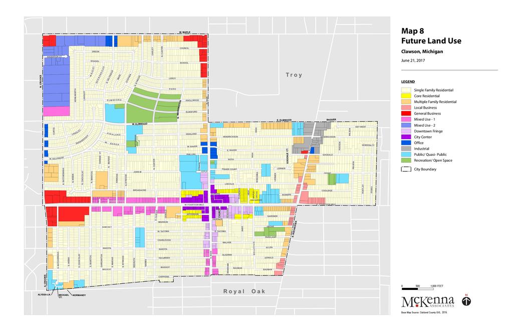
75
76


77 SINGLE FAMILY RESIDENTIAL The City of Clawson is predominately a residential community, with the majority belonging to single family housing. Community residents and stakeholders prioritize the preservation and maintenance of the existing housing stock within Clawson. The City s stable, single-family neighborhoods are intended to remain intact going forward. Measures to protect the character of those neighborhoods, such as regulations that ensure new or remodeled homes remain in scale with the existing housing stock, should be undertaken. DOWNTOWN The City adopted the Downtown Master Plan in 2015, and its policies are incorporated herein by reference. MULTIPLE FAMILY RESIDENTIAL Incorporating a variety of housing options within a community can be attractive to all age groups from Millennials to Baby Boomers, and will allow them to remain within a community as their particular needs and wishes change over time. The needs of young adults differ from older adults with families and differ from empty nesters nearing retirement. Areas appropriate for multiple family housing have generally been designated along the City s major thoroughfares, including within mixed use districts contemplated for the 14 Mile Road and Main Street corridors. BUSINESS In the past, a distinction has been made between parcels that are small in size and are limited by building square footage and availability in off street parking, which were often designated for uses that serve the local community, such as restaurants, cafes, and small scale retail, and those that are generally larger in scale and serve more regional needs, often, lumped together in strip malls with large swaths of parking located along the front of the property. This latter category has included pharmacies, chain retail establishments, grocery stores, and the like. The City believes that these distinctions have often proven to be an unnecessary burden on creativity and entrepreneurship. Going forward, districts should be developed for the City s main commercial corridors, along 14 Mile Road and along Main Street, outside of the downtown, that afford the same sort of flexibility as is available to downtown uses, relying more heavily on design considerations to achieve a harmonious relationship between uses as opposed to use 2017 MASTER PLAN CITY OF CLAWSON, MI 65
78 restrictions. Districts should afford flexibility to allow the Planning Commission to recognize new business concepts as they evolve. A local commercial distinction will continue to be appropriate at the intersection of 14 Mile and Rochester Roads, due to its setting amidst surrounding residential uses. The northern and western gateways to the City, and the southern end of Rochester Road, will have a more strictly commercial orientation, as has historically been the case. MIXED USE As discussed above, these areas, located on 14 Mile Road and Main Street, and at the intersection of Crooks and Maple Roads, are intended to allow a flexible mixture of compatible uses, as more particularly described below. There is a larger emphasis upon aesthetics, landscaping, and design to assure compatibility. MU-1: 14 MILE ROAD AND MAIN STREET The downtown area is the focal point of the City. The walkable and pedestrian friendly sidewalks and streetscapes encourage pedestrian activity. However, those welcoming and friendly elements currently diminish at the downtown district boundary. The continuation of similar downtown character features, such as street trees, bike racks, planter boxes, maintained sidewalks, and benches would encourage pedestrians to venture beyond the downtown district to visit other nearby businesses without relying upon the personal vehicle. Likewise, the incorporation of multiple-family residential uses along the corridor will help generate additional demand for shopping and dining. A Mixed Use Commercial District along 14 Mile Road and South Main Street is intended, to allow for additional businesses to serve the community, while also providing alternative housing options. Increasing the variety of housing near the downtown will tend to attract those who would choose to live in a bustling community without the maintenance required from living in a single-family detached structure. Live-work units could also be appropriate. MU-2: CROOKS AND MAPLE ROADS The corner of Crooks and Maple is the northwest boundary of the City and also represents an entrance into the City of Troy. There are large parcels here, many in a business park setting that can accommodate more expansive land uses than much of the rest of the City. This area is appropriate for office and light industrial type uses that are not inconsistent with the fact the runway approach protection zone for the Oakland-Troy Airport overlies a portion of it. Artisan-type uses that can benefit from industrial workspaces would also be appropriate uses here. 66 MARCH 13, 2018


79 OFFICE This designation denotes areas appropriate for office and similar, compatible uses. These properties front major thoroughfares and represent a transition from other, more intense uses. INDUSTRIAL Industrial uses are planned for the northern portion of Rochester Road in the City, to include wholesale activities, warehouses, and industrial operations whose external and physical effects are restricted to the immediate area having only a minimal effect on surrounding districts. Certain automotiverelated commercial uses are also appropriate for this area. PUBLIC/QUASI-PUBLIC This designation includes government service buildings such as City Hall, DPW, the Library, and the Historical Museum. It also includes school facilities such as elementary, middle, high school and administrative buildings. Public/Quasi-Public would also include places of worship, non-profits, and other service organizations. RECREATION/OPEN SPACE This designation encompasses areas within Clawson that are publicly owned and intended to remain so in the future. It includes the City s parks and recreation system. The Clawson Parks and Recreation Master Plan focuses on the development and long-range planning ideas for the parks and recreation facilities MASTER PLAN CITY OF CLAWSON, MI 67
80

81 10 SUSTAINABILITY AND GREEN INFRASTRUCTURE ENVIRONMENTAL SUSTAINABILITY AND GREEN INFRASTRUCTURE The most widely accepted definition of sustainability is meeting today s needs without compromising the ability of future generations to meet their own needs. Urban development should be guided by a sustainable planning and management vision that promotes interconnected green space, a multi-modal transportation system, and mixed use development. The path towards sustainability is rooted in three pillars: Economic Development, Social Progress, and Environmental Responsibility MASTER PLAN CITY OF CLAWSON, MI 69

82 Figure 9: Sustainability Pillars There is no straight forward path towards becoming a sustainable community. The most challenging aspect may come from receiving support from the community that would most benefit from incorporating sustainable practices. Communicating the importance of the invisible problems and educating the public on the merits of new policies and procedures may not be the easiest task. Incorporating sustainable development practices will have longterm benefits that will outweigh short-term challenges. SUSTAINABLE DESIGN Communities that follow sustainable design standards for land use will have achieved the center point of the above diagram; a harmony between economic development, environmental responsibility, and social progress. The Sustainable Cities Institute developed the following principles of land use that should be implemented to foster a sustainable community. Open Space. Open green space is key to the environmental benefits of a community, including improved air quality. It will also encourage residents to utilize the space for active and passive uses. Walkability and Connectivity. The City has undertaken several streetscape revitalization efforts within the downtown to create a more walkable and connected area. The Future Land Use Map demonstrates a focus to expand the walkability and connectivity that is central to the downtown district. Integration of Diverse Community Features. The City should incorporate a variety of community facilities that services local residents and fulfills their needs. This will better serve the community to reverse adverse effects of sprawl by incorporating higher density, such as missing middle housing. Strong Sense of Place. The Future Land Use Map focuses on the downtown district, commercial gateways, and the mixed-use developments to enhance and promote the strong sense of place within Clawson and its connection to the region. Additional principles for fostering a sustainable community include cultivating renewable energy and implementing green building design. Renewable Energy. Solar power has grown in popularity and is becoming an affordable method of renewable energy for families and businesses. Paving the way towards a more sustainable future, solar power systems derive energy from the sun, thereby reducing overall dependence on fossil fuels. A 2015 study by researchers at the Massachusetts Institute of Technology examined the future of solar electricity generation in the United States and aimed to provide resources and recommendations for decision-makers. Green Building. A focus on land use planning and building design to protect the natural environment are two significant steps toward a sustainable community. The Environmental Protection Agency identified several potential environmental, economic, and social benefits of green building. They include: Enhance and protect biodiversity and ecosystems 70 MARCH 13, 2018
83 Improve air quality and water quality Conserve and restore natural resources Reduce operating costs Heighten aesthetic qualities Minimize strain on local infrastructure Improve overall quality of life GREEN INFRASTRUCTURE Green infrastructure, often referred to as Low Impact Development (LID), is an approach to water management that protects and restores the natural water cycle. It means planting trees, restoring wetlands and managing stormwater run-off that will erode the soil and natural resources and will eventually overburden the community s municipal water system. Such techniques do not require wide swaths of natural open land, but can be implemented in residential and commercial districts of varying sizes and populations. Often the biggest challenge to implementing green infrastructure is funding. The most appropriate techniques in a given location will largely depend on goals and budget, but green infrastructure can be designed to work in all communities. Permeable Pavement. Permeable pavement allows for the movement of rainwater to filter through the pavement s surface, with water eventually seeping into the undersoil. They can be used on driveways, parking lots, and low-traffic roadways. Unlike standard concrete or asphalt, permeable pavement can be installed in a variety of patterns and colors to allow aesthetic appeal. Rain Gardens. Rain gardens are a low-level garden that allows for rainwater runoff from impervious surfaces like roadways, driveways, or parking lots. The gardens will capture rainwater before it pollutes local rivers or lakes, thereby preventing habitual flooding and overburdening an aging infrastructure system. The gardenscapes will include deeprooted native flowers, bushes, and trees to attract honeybees, butterflies and local birds. Rain Barrels / Cisterns. The roof water management devices provide above or underground rainwater storage tanks. They can be installed in various sizes, depending on volume requirement, on residential, commercial, and industrial sites. The rainwater can then be harvested to water gardens and lawns. Rainwater harvesting is a simple way to conserve water and protect the environment. Green Roofs. A green roof is a roof of a building that is partially or completely covered in vegetation. They are an effective strategy for beautifying the built environment, and have become the easiest identifiable symbol of the green building movement. By making flora a part of the urban landscape, there will be improved air quality, stormwater management, and reduction in the urban heat island effect. The creation of these spaces and the aesthetic improvements will be a marketing incentive to those interested in the multiple benefits offered by green roofs. Living walls or green walls provide similar community benefits to air quality, reduction of the urban heat island effect, marking potential, and aesthetic stimulation. Urban Tree Canopy. Urban tree canopy (UTC) is the coverage of leaves and branches of trees when viewed from above. Many communities have set tree canopy goals to restore some of the benefits of trees that were lost when areas were being developed. Trees improve air quality, reduce atmospheric carbon dioxide, reduce urban heat island effect, and contribute to the overall beauty and character of a community. Additionally, trees have been linked to a higher quality of life by enhancing the area s sense of place MASTER PLAN CITY OF CLAWSON, MI 71
84 Land Conservation. Land conservation is the largest scale green infrastructure technique. Protecting and preserving natural areas should continue to be a major focus, where applicable, as it will reduce stormwater run-off and urban heat island effect. Further, protecting natural areas can provide recreational opportunities for residents and will contribute to the overall sense of place of a community. FUTURE ACTIONS Prepare a Sustainability Plan. To maximize efforts, the City should prepare and adopt a Sustainability Plan that will be framed by policies and the overall vision of the community. The Plan should be implemented through specific goals, objectives, and actions. A Sustainable Committee or similar advisory body could be created that includes City officials, business and community leaders, and City residents. Incorporate Green Design Standards. Incorporating green building design into the development standards for appropriate districts will promote sustainability in the development and redevelopment of property. Encourage Adaptive Reuse. Wherever feasible, existing buildings and site improvements should be repurposed to serve future needs, which also helps retain community character. 72 MARCH 13, 2018

85 11 IMPLEMENTATION The City of Clawson Master Plan serves as the broad framework within which the City will guide future land use. Implementation of this Plan will require the ongoing efforts of City officials, Planning Commissioners, Zoning Board of Appeals members, Downtown Development Authority, neighboring agencies, and citizens. The effectiveness of the Plan relies upon the diligence with which its provisions are implemented. When properly applied, the Zoning Ordinance accepts the realities of existing land uses and gradually, as new development or redevelopment is proposed, directs growth toward achieving the goals and policies of the Master Plan. As rezonings are considered, they should be compared to the goals, policies, and future land use designation of this Master Plan. Finally, this Master Plan should be a flexible document that changes as the character of the community and its people change over time. This Plan should be periodically (at least once every five (5) years) reviewed and amended, as necessary, to remain up-to-date. It should be remembered that the Master Plan is the best estimate of what would be the desirable land use configuration of the community in the future, from a point in time at the present. As time moves on, this concept of a desirable community may change, so the Plan must be flexible in order to accommodate that change. That said, consistency and consistency of purpose will also be important to achieving the Plan s goals MASTER PLAN CITY OF CLAWSON, MI 73
86 KEEPING THE PLAN UP-TO-DATE Change is constant and often unpredictable, and there may be circumstances that warrant changes to the zoning boundaries that are not consistent with the Master Plan. If and when this occurs, the Master Plan should be updated to conform to the changed circumstances. Because of the time and process required for amending the Plan, such changes should be considered carefully. Table 8 contains a series of evaluation factors that may be used to determine if a proposed development warrants a change to the land use designation on the Future Land Use Plan map. Table 8: Future Land Use Evaluation Factors Does the proposed, new classification meet the qualifications noted in the appropriate section of the Master Plan? Are the zoning districts and their uses that may apply to the new classification compatible with, and appropriate in, the vicinity of the property under consideration? Have any conditions changed in the area since the Master Plan was adopted that justify a revision? Will there be any community impacts that should be considered, such as increased traffic, or others that might create a need for additional services or improvements? Are there any environmental considerations that may be contrary to the intent of the existing or proposed classification of that land use? Was the property improperly classified when the Plan was adopted or amended? Are the qualities of the property (or area) different from those that are described in the Plan? Will there be any adverse effects on adjacent properties as a result of the proposed land change? What impacts will result to the public health, safety, and welfare? FUNDING Successful implementation of some of the goals of the Master Plan may depend on the ability of the City to secure necessary financing. Besides the general fund, the following revenue sources are available to the City: DEDICATED MILLAGE A special millage can be used to generate revenue for a specific purpose. A dedicated millage may include: recreation, road maintenance, police, fire, museum, zoo, or any other special dedicated millage. SPECIAL ASSESSMENTS Special assessments are compulsory contributions collected from the owners of property benefitted by specific public improvements, such as paving and drainage improvements, to defray the costs of such improvements. Special assessments are apportioned according to the benefits afforded to the property affected. BOND PROGRAMS Bonds are on the principal sources of financing used by communities to pay for capital improvements. General obligation bonds are issued for specific community projects and are paid off by the general public with property tax revenues. Revenue bonds are issued for the construction of projects that generate revenue, like parking structures. These bonds are then retired using income generated by the project. 74 MARCH 13, 2018
87 PROJECT PRIORITIES The actions are listed with a priority number as follows: Priority 1 projects are those that should be given immediate and concentrated effort. These are the first projects that should be addressed after the Master Plan has been adopted. Any preliminary steps that must be taken to implement the action (such as seeking funding, changes in local ordinances, etc.) should be commenced immediately. Those Priority 1 projects that have a longer time horizon should be revisited on an as-needed basis and should be incorporated into other applicable long-term planning programs, such as capital improvements plan. Priority 2 projects are those that are necessary to implement the plan, but either depend upon commencement or completion of Priority 1 projects, or do not have the same immediacy of Priority 1 projects. Once commenced, however, these projects should be considered important and should be pursued until completion. Priority 3 projects are those that implement elements of this plan, but are not urgent and can be delayed for a longer period of time. These projects are more susceptible to budgetary constraints. Some projects within the matrix do not have a specified timing period because they are based on less predictable factors such as land availability, etc. The timing for these projects is explained within the matrix below MASTER PLAN CITY OF CLAWSON, MI 75
88 Table 9: Goals and Objectives Action Responsibility Priority Priority 1 Survey Results Support Review the Zoning Ordinance to determine if any existing regulations inhibit implementation of this Plan, and make changes as necessary. PC 1 Question 20 Review and initiate amendments to the Zoning Map in order to implement this Plan. PC 1 N/A Adopt design requirements in the Zoning Ordinance for new development where appropriate, including mixed-use development, commercial business, and residential provisions. PC 1 Questions 15, 18 Remove ordinance restrictions to bicycle use downtown. CC 1 Question 14 Update Parks and Recreation Master Plan. CC 1 Questions 11, 13 Encourage citizen participation in community planning decisions. A/PC 1 Question 26 Priority 2 Incorporate plan priorities into Capital Improvement Plan. CC 2 N/A Educate property owners about property maintenance. A 2 Question 13 Work with Downtown Development Authority to enhance business attraction and retention. A 2 Questions 21, 26 Promote green building practices in new construction or redevelopment. A 2 Question 15 Provide for sustainable development, green infrastructure, and low impact development techniques in development standards. Develop and implement a streetscape improvement plan for Rochester Road, 14 Mile Road and Main Street outside of Downtown. PC 2 Question 15 CC 2 Question 13 Review Clawson s parking regulations and encourage alternative strategies to serve community needs. PC / CC 2 Questions 14, 20 Undertake a Corridor Improvement Study and related improvements for Rochester Road. CC 2 Question 13 Work with DPW to improve pedestrian and bicycle accommodations and existing crosswalks in the City. A 2 Questions 14, 15 Review existing code enforcement program and update as necessary. A 2 Question 15 Partner with schools to enhance youth activities and after school programs. A 2 N/A Partner with Clawson Senior Center to enhance activities and programs that would appeal to the aging population. A 2 N/A Promote the Clawson Farmer s Market to citizens and local restaurants. A 2 N/A Promote activities to attract people to local businesses; including partnering with DDA. A 2 Questions 13, 21 Priority 3 Partner with neighboring cities to strategize redevelopment activities, pedestrian crossings along shared thoroughfares. A 3 N/A Create, fund, and implement a wayfinding sign plan throughout the City. A 3 Question 14 Complete and implement a Housing Analysis to determine future housing and development needs that would best suit the community. Develop additional mid-block pedestrian crossings along major roadways to encourage walkability and pedestrian friendly atmosphere within community. A / CC 3 Questions 10, 16 A / CC 3 Questions 13, 21 Develop and implement Rochester Road façade renovation program. CC 3 Question 13 Establish housing assistance programs for the elderly and needy, working with the Michigan State Housing Authority. CC 3 Question 10 Upgrade community facilities, as necessary. CC 3 Question 13 Establish beautification programs to reward property stewardship in the business community. A/CC 3 Question MARCH 13, 2018
89 ZONING PLAN Per the requirements of the Michigan Planning Enabling Act of 2008, a Zoning Plan is required that correlates the Future Land Use categories of the Master Plan with the zoning districts found on the current official Zoning Map for the City of Clawson. If none of the existing zoning districts match any particular future land use category, then the Zoning Plan should indicate a new zoning district to be designated for that category. The Zoning Plan is described by the following: Table 10: Zoning Plan for the City of Clawson Future Land Use Category Single Family Residential Core Residential Multiple Family Residential Local Business General Business Mixed Use 1 Mixed Use 2 Downtown Fringe City Center Office Industrial Public / Quasi-Public Recreation / Open Space Zoning District R-1, Single Family Residential-1 R-2, Single Family Residential-2 CMD-2, Central Mixed Development-2 RM-1, Multiple Family Residential (Low Rise) RM-2, Multiple Family Residential (High Rise) B-1, Local Business B-3, General Business BRD-1, Business Renewal District-1 PUD, Planned Unit Development * New Zoning District * BRD-2, Business Renewal District-2 PUD, Planned Unit Development CMD-2, Central Mixed Development-2 CC, City Center O-1, Office Service I-1, Limited Industrial I-2, General Industrial O-1, Office Service R-1, Single Family Residential-1 R-2, Single Family Residential-2 * Possible New Zoning District * (PL, Public Land) R-1, Single Family Residential-1 R-2, Single Family Residential-2 * Possible New Zoning District * (PL, Public Land) The following existing zoning districts do not correlate to any Future Land Use category: O-2, Office Research B-2, Central Business The VP, Vehicular Parking District, is appropriate for nonresidential uses which are not able to provide adequate space within their own district boundaries. Such areas will generally be provided by petition or request to serve a use district which has developed without adequate off-street parking facilities MASTER PLAN CITY OF CLAWSON, MI 77
90

91 APPENDIX A: SURVEY RESULTS A 2017 MASTER PLAN CITY OF CLAWSON, MI 79
CITY OF CLAWSON MASTER PLAN. Public Hearing and Planning Commission Recommendation December 9, 2008
 CITY OF CLAWSON MASTER PLAN Public Hearing and Planning Commission Recommendation December 9, 2008 City Council Adoption January 20, 2009 Acknowledgements Mayor Penny Luebs Lisa Dwyer (former) City Council
CITY OF CLAWSON REQUEST FOR PROPOSALS FOR PLANNING SERVICES
 CITY OF CLAWSON REQUEST FOR PROPOSALS FOR PLANNING SERVICES SUMMARY: The City of Clawson requests proposals to provide professional planning services. SUBMISSION: Please submit three (3) single-sided original,
Efficient Existing Public Buildings { BP no. 1 }
 City of Brooklyn Center Background Information County: Hennepin Population: 30,104 GreenStep City category: A Full-time equivalent city staff (approx.): 75 Participating township(s) / school district(s):
THE ALLEY SHOPS PORTFOLIO SALE
 THE 1326-1330 & 1420-1426 REISTERSTOWN ROAD, PIKESVILLE, MD 21208 Gilbert R. Trout 443.921.9332 gtrout@troutdaniel.com Table Of Contents Conidentiality & Disclaimer All materials and information received
REPORT
 www.lilburncid.com 2017 REPORT BOARD MEMBERS Jim Vaught CID Chairman Ed O Connor CID Vice Chairman John Souter CID Secretary/Treasurer Bruce Arnett Jr. Chairman of Souter Enterprises Carnett s Management
Welcome to the Narberth 2040
 Welcome to the Narberth 2040 Comprehensive Plan Community Survey! Narberth Borough is in the process of drafting its first comprehensive plan and we need your input! The plan will outline the community
City of Lilburn 76 Main Street Lilburn, GA City Council Meeting Agenda
 City of Lilburn 76 Main Street Lilburn, GA 30047 City Council Meeting Agenda Auditorium Monday, May 11, 2015 7:30 p.m. Council Johnny Crist, Mayor Teresa Czyz, Post 1 Scott Batterton, Post 2 Eddie Price,
BEFORE THE HEARING EXAMINER FOR THURSTON COUNTY
 COUNTY COMMISSIONERS Cathy Wolfe District One Diane Oberquell District Two Robert N. Macleod District Three Creating Solutions for Our Future HEARING EXAMINER BEFORE THE HEARING EXAMINER FOR THURSTON COUNTY
Evaluation of potential mergers of the Provo-Orem MSA and the Ogden-Clearfield MSA with the Salt Lake City MSA
 To: From: Michael Parker, Vice President of Public Policy, Salt Lake Chamber Pamela S. Perlich, Director of Demographic Research Juliette Tennert, Director of Economic and Public Policy Research Date:
Jeff Straub, Interim City Manager Ted Hejl, City Attorney Susan Brock, City Clerk
 The City Council of the City of Taylor met on February 27, 2014, at City Hall, 400 Porter St. Taylor, Texas. Noting the absence of Mayor Pro Tern due to illness, Mayor Jesse Ancira, Jf declared a quorum
ST. ANN'S CHURCH $1,450, S LEAVITT STREET CHICAGO, IL SVN CHICAGO COMMERCIAL 940 WEST ADAMS STREET, SUITE 200, CHICAGO, IL 60607
 ST. ANN'S CHURCH $1,450,000.00 1820 S LEAVITT STREET CHICAGO, IL 60608 SVN CHICAGO COMMERCIAL 940 WEST ADAMS STREET, SUITE 200, CHICAGO, IL 60607 SALE PROPOSAL PROPERTY INFORMATION 3 Property Summary Property
OSHTEMO CHARTER TOWNSHIP ZONING BOARD OF APPEALS MINUTES OF A SPECIAL MEETING HELD JUNE 12, 2014
 OSHTEMO CHARTER TOWNSHIP ZONING BOARD OF APPEALS MINUTES OF A SPECIAL MEETING HELD JUNE 12, 2014 Agenda MOPHIE, LLC -REQUEST FOR SITE PLAN REVIEW OF A PROPOSED 37,000 SQUARE FOOT ADDITION TO AN EXISTING
City of Ely. Background Information. GreenStep Coordinator. County: St. Louis. Population: 3,460. GreenStep City category: B
 City of Ely Background Information County: St. Louis Population: 3,460 GreenStep City category: B Full-time equivalent city staff (approx.): 38 Participating township(s) / school district(s): GreenStep
Draft 11/20/2017 APPENDIX C: TRANSPORTATION PLAN FORECASTS
 APPENDIX C: TRANSPORTATION PLAN FORECASTS To determine future roadway capacity needs, year 2040 traffic forecasts were prepared using the Metropolitan Council travel demand model. The model was refined
VILLAGE OF KINDERHOOK DISCOVER THE OPPORTUNITIES
 VILLAGE OF KINDERHOOK DISCOVER THE OPPORTUNITIES OUR SHARED VISION The Village of Kinderhook will be an attractive, vibrant, and inviting place to live, work and visit. The Village has unique historic
Goals, Objectives, & Recommendations
 Looking Forward While Respecting the Past Between 2006 and 2008, the Nauvoo Comprehensive Plan Committee and other members of the community met and established community development goals, objectives,
2017 MASTER PLAN CITY OF CLAWSON, MI. Prepared by the City of Clawson Planning Commission with the Assistance of McKenna Associates
 2017 MASTER PLAN CITY OF CLAWSON, MI Prepared by the City of Clawson Planning Commission with the Assistance of McKenna Associates 235 East Main Street, Suite 105 Northville, Michigan 48167 t: 248.596.0920
Conversations Sample Report
 Conversations Sample Report 9/4/18 "And this is my prayer: that your love may abound more and more in knowledge and depth of insight, so that you may be able to discern what is best and may be pure and
TOWN OF MAIDEN. March 20, 2017 MINUTES OF MEETING
 TOWN OF MAIDEN March 20, 2017 MINUTES OF MEETING The Maiden Town Council met on Monday, March 20, 2017 at 7:00 p.m. for their regular meeting, held in the Council Chambers at the Maiden Town Hall. Present
JANICE MENKING - Chair CHARLIE KIEHNE CHRIS KAISER STEVE THOMAS RON WOELLHOF JASON HELFRICH MATT LINES BJORN KIRCHDORFER
 STATE OF TEXAS PLANNING & ZONING COMMISSION COUNTY OF GILLESPIE December 7, 2011 CITY OF FREDERICKSBURG 5:30 P.M. On this the 7 th day of December, 2011, the PLANNING AND ZONING COMMISSION convened in
Department of Planning & Development Services
 Department of Planning & Development Services S T A F F R E P O R T August 27, 2014 CASE NO: PROJECT: EXECUTIVE SUMMARY: DETAILS: ZA14-023 Preliminary Plat for Silver Ridge Addition Phase III The applicant
CITY OF SOUTH SALT LAKE CITY COUNCIL WORK MEETING. COUNCIL MEETING Wednesday, November 9, :17 p.m.
 CITY OF SOUTH SALT LAKE CITY COUNCIL WORK MEETING COUNCIL MEETING Wednesday, November 9, 2016 6:17 p.m. CITY OFFICES 220 East Morris Avenue #200 South Salt Lake, Utah 84115 PRESIDING CONDUCTING Council
Does your church know its neighbours?
 Does your church know its neighbours? A Community Opportunity Scan will help a church experience God at work in the community and discover how it might join Him. Is your church involved in loving its neighbours?
Commenter ID Number by Topic and Themes: Appendix B
 Impacts of These are difficult economic times (e.g., the economy is bad, people are not receiving salary increases, businesses are suffering, and the cost of living is rising), and the present DTR tolls
Planning and Zoning Staff Report Corp. of Presiding Bishop LDS Church - PH
 Planning and Zoning Staff Report Corp. of Presiding Bishop LDS Church - Hearing Date: February 1, 2018 Development Services Department Applicant/Property Owner: Corp of the Presiding Bishop LDS Church
PROFITS THROUGH PRESERVATION
 PROFITS THROUGH PRESERVATION The Economic Impact of Historic Preservation in Utah TECHNICAL REPORT Jobs and Income Heritage Tourism Property Values Sustainability Downtown Revitalization Fiscal Responsibility
CABLE/ VOLTAIRE, VOLTAIRE AND 4920 VOLTAIRE SAN DIEGO, CA OFFERING MEMORANDUM
 2216-2218 CABLE/4904-4906 VOLTAIRE, 4912-4918 VOLTAIRE AND 4920 VOLTAIRE SAN DIEGO, CA 92107 OFFERING MEMORANDUM PRESENTED BY Judy Preston CA BRE Lic. 01074104 619.309.9559 Judy@TeamPreston.net Jim Greer
WESTWOOD BAPTIST CHURCH SENIOR PASTOR PROFILE
 WESTWOOD BAPTIST CHURCH SENIOR PASTOR PROFILE ABOUT WESTWOOD BAPTIST CHURCH Located in the Birmingham, Alabama suburb of Alabaster in Shelby County, Westwood desires to be a church that knows and cares
ADAMS COMMUNITY REINVESTMENT AREA (CRA)
") ADAMS COMMUNITY REINVESTMENT AREA (CRA) - Proposed Draft Plan Set or Not Set Public Hearing for January 9, 2018 The Board will consider setting a public hearing on the Adams Community Reinvestment Area
ADAMS COMMUNITY REINVESTMENT AREA (CRA) - Proposed Draft Plan Set or Not Set Public Hearing for January 9, 2018 The Board will consider setting a public hearing on the Adams Community Reinvestment Area
Evangelical Lutheran Church in Canada Congregational Mission Profile
 Evangelical Lutheran Church in Canada Congregational Mission Profile Part I Congregation Information 1. Congregation Congregation ID Number: Date Submitted: Congregation Name: Address: City: Postal Code:
RETAIL AT SUNSTONE VILLAGE
 RETAIL AT SUNSTONE VILLAGE WITHIN 1KM HOUSEHOLD INCOMES SIGNIFICANTLY ABOVE AVERAGE HIGH RATE OF HOME OWNERSHIP LIMITED RETAIL OFFERINGS COMING LATE 2019 RETAIL OPPORTUNITY FOR LEASE Adam Frizzell Associate
Resolution Related to a Comprehensive Urban Ministry Strategic Plan
 Resolution Related to a Comprehensive Urban Ministry Strategic Plan Submitted by: Commission on Urban Ministry Presenters: Robin Hynicka and Lydia Munoz Whereas, the Commission on Urban Ministry is charged
Merrimack Valley Community Assessment
 Merrimack Valley Community Assessment A report by Elder Monte Sahlin Center for Creative Ministry August 9, 2011 Who is Monte Sahlin? An ordained Seventh-day Adventist minister for 40 years who has done
CHARTER TOWNSHIP OF NORTHVILLE Zoning Board of Appeals October 17, 2018
 CHARTER TOWNSHIP OF NORTHVILLE Zoning Board of Appeals October 17, 2018 DATE: October 17, 2018 APPROVED: November 14, 2018 TIME: 7:00 P.M. PLACE: Northville Township Hall 44405 Six Mile Road CALL TO ORDER:
CITY OF CLAWSON MINUTES OF A MEETING OF THE PLANNING COMMISSION TUESDAY, APRIL 14, 2015
 CITY OF CLAWSON MINUTES OF A MEETING OF THE PLANNING COMMISSION TUESDAY, APRIL 14, 2015 A regular meeting of the Planning Commission was called to order by Chairman Blanchette at 7:30 P.M. ROLL CALL PRESENT:
TABLE OF CONTENTS. Introduction 3 Preparing for the Future / Building from the Past 4 The Planning Process 7 Participants Involved 8
 P A I N E S V I L L E DOWNTOWN MASTER PLAN Revitalizing an established place into a sustainable community of the future February 2009 Painesville, Ohio TABLE OF CONTENTS Introduction 3 Preparing for the
Centerville Community Assessment. A report by Elder Monte Sahlin Ohio Conference August 2011
 Centerville Community Assessment A report by Elder Monte Sahlin Ohio Conference August 2011 Goals of this Study o Profile the demographics and religion of Centerville. o Provide a community needs assessment.
Strategic Planning Update for the Diocese of Evansville
 Strategic Planning Update for the Diocese of Evansville November 2012 2 The following Q&A features the latest information about the strategic planning initiative currently underway in our diocese. This
El Monte Community Assessment. A report by Elder Monte Sahlin Center for Creative Ministry August 2011
 El Monte Community Assessment A report by Elder Monte Sahlin Center for Creative Ministry August 2011 1 Who is Monte Sahlin? An ordained Seventh-day Adventist minister for 40 years who has done assessments
RESCHEDULED MEETING OF THE BOARD OF DIRECTORS OF THE CITY OF TEXARKANA, ARKANSAS JULY 5, 2006
 RESCHEDULED MEETING OF THE BOARD OF DIRECTORS OF THE CITY OF TEXARKANA, ARKANSAS JULY 5, 2006 MEMBERS PRESENT: The Board of Directors of the City of Texarkana, Arkansas, convened in rescheduled regular
Centenary Downtown. Strategic Plan Doing God s Will in Richmond. Vision Statement. Staffing. Church Governance. Church Finances 2017 Goal
 Vision Statement Staffing Church Governance Church Finances 2017 Goal 2017 Goal 2017 Goal 2017 Goal Centenary Downtown Strategic Plan 2017 2020 Doing God s Will in Richmond Music Ministry 2018 2020 Goals
Subject to change as finalized by the City Clerk. For a final official copy, contact the City Clerk s office at (319)
") Subject to change as finalized by the City Clerk. For a final official copy, contact the City Clerk s office at (319)753-8124. MINUTES OF THE PROCEEDINGS OF THE BURLINGTON, IOWA CITY COUNCIL Meeting No.
Subject to change as finalized by the City Clerk. For a final official copy, contact the City Clerk s office at (319)753-8124. MINUTES OF THE PROCEEDINGS OF THE BURLINGTON, IOWA CITY COUNCIL Meeting No.
Sprague Planning & Zoning Commission Regular Meeting Minutes Wednesday, January 2, 2019
 Sprague Planning & Zoning Commission Regular Meeting Minutes Wednesday, January 2, 2019 Members Present: Sandor Bittman, Chairman Paul Piezzo Nicholas Velles Arthur Spielman Warren Baker Phyllis Nelson
Transition Summary and Vital Leader Profile. The Church Assessment Tool 5/3/16
 Transition Summary and Vital Leader Profile generated from The Church Assessment Tool 5/3/16 "And this is my prayer: that your love may abound more and more in knowledge and depth of insight, so that you
ASHLEY OAKS PLAZA. A total re-invention of a 57,400 SF retail center in the heart of Charleston s greatest opportunity: West Ashley
 ASHLEY OAKS PLAZA A total re-invention of a 57,400 SF retail center in the heart of Charleston s greatest opportunity: West Ashley 1119 WAPPOO ROAD,, SC 29407 RETAIL & RESTAURANT OPPORTUNITIES AVAILABLE
Frequently Asked Questions Commuter Rail
 Frequently Asked Questions Commuter Rail What is Commuter Rail? Wikipedia defines commuter rail as a passenger rail transport service between a city center, and outer suburbs and commuter towns or other
13400 South & Mountain View Corridor Riverton, Utah. Leasing Information
 13400 South & Mountain View Corridor Riverton, Utah Leasing Information Mountain View Village will be an 85-acre mixed-use development in Riverton, Utah. You can ski, hike, bike and boat all within a short
May 2, 2018 BETA Workshop HARRIMAN THE CHAZEN COMPANIES
 May 2, 2018 BETA Workshop HARRIMAN THE CHAZEN COMPANIES Village of Mamaroneck, New York April 4, 2018 1 Agenda Introductions Presentation Goals and Process Zoning and Implications Results of Public Workshop
October 5, Ref: Montgomery County Department of Permitting Services 255 Rockville Pike 2nd Floor Rockville, MD 02850
 255 Rockville Pike 2nd Floor Rockville, MD 02850 Re: JSS Spirtual Mission Temple 7710 Hawkins Creamery Road Gaithersburg, MD I. Introduction The purpose of this memorandum is to provide a brief introduction
PROPOSALS MUST BE RECEIVED NO LATER THAN: 5:00 p.m., April 30, Proposals received after this time will not be evaluated.
 BRIGHAM CITY CORPORATION (www.brighamcity.utah.gov) REQUEST FOR PROPOSALS 1100 W. Highway 91 Intersection Design PROPOSALS MUST BE RECEIVED NO LATER THAN: 5:00 p.m., April 30, 2012. Proposals received
CHURCH PROFILE PASTORAL PROFILE COMMUNITY PROFILE OUR HISTORY OUR MISSION OUR MINISTRY OUTCOMES OUR MINISTRY OUTCOMES (CONTINUED) OUR MINISTRIES
 OUR MINISTRIES") 2150 N. 122nd St, Seattle, WA 98133 206-363-7570 nsachurch.org P2 P3 P4 P5 P6 CHURCH PROFILE OUR HISTORY OUR MISSION OUR MINISTRY OUTCOMES OUR MINISTRY OUTCOMES (CONTINUED) OUR MINISTRIES OUR MINISTRIES
2150 N. 122nd St, Seattle, WA 98133 206-363-7570 nsachurch.org P2 P3 P4 P5 P6 CHURCH PROFILE OUR HISTORY OUR MISSION OUR MINISTRY OUTCOMES OUR MINISTRY OUTCOMES (CONTINUED) OUR MINISTRIES OUR MINISTRIES
Center for Applied Research in the Apostolate
 Special Report: Parish Life Today About CARA CARA is a national, non-profit, Georgetown University affiliated research center that conducts social scientific studies about the Catholic Church. Founded
Dallas Municipal Archives Archives Collections Finding Guides and Inventories
 Archives Collections Finding Guides and Inventories Guide No. 17 City of Kleberg, Texas 1956-1978 (Collection 91-064) Processed by: Cindy Smolovik, CA, CRM Records Management Division Collection Range:
REGULAR MEETING, WARRENSBURG TOWN BOARD, DEC. 12, 2012
 The regular meeting of the Warrensburg Town Board was held on Wednesday, December 12, 2012 at the Albert Emerson Town Hall at 7:00 p.m. with the following members present: PRESENT: Supervisor Kevin Geraghty
3. Discussion and/or action to add one member (citizen) to the Public Works Committee.
 to the Public Works Committee.") Public Works Committee meeting October 6, 2010 4pm Present: Richard G. Harris Mayor Annette Spendlove City Recorder/ HR Director Dave Hulme Planning Commissioner Jim Harris Project Manager Mel Blanchard
Public Works Committee meeting October 6, 2010 4pm Present: Richard G. Harris Mayor Annette Spendlove City Recorder/ HR Director Dave Hulme Planning Commissioner Jim Harris Project Manager Mel Blanchard
BANNER ELK TOWN COUNCIL. July 12, 2016 MINUTES
 BANNER ELK TOWN COUNCIL MINUTES The Banner Elk Town Council met Monday, at 6:00 p.m. at the Banner Elk Town Hall for their regular scheduled meeting. Council Members present: Mayor Brenda Lyerly, Mike
The best estimate places the number of Catholics in the Diocese of Trenton between 673,510 and 773,998.
 Number of Catholics Living in the Diocese of Trenton It is impossible to verify how many individual Catholics reside in the Diocese of Trenton. Not all are registered in parishes, and the U.S. Census does
2015 Vision Plan OUR GUIDING TEXT
 2015 Vision Plan OUR GUIDING TEXT John 15: 8, 16 My Father is glorified by this, that you bear much fruit and become my disciples. You did not choose me but I chose you. And I appointed you to go and bear
South-Central Westchester Sound Shore Communities River Towns North-Central and Northwestern Westchester
 CHAPTER 9 WESTCHESTER South-Central Westchester Sound Shore Communities River Towns North-Central and Northwestern Westchester WESTCHESTER 342 WESTCHESTER 343 Exhibit 42: Westchester: Population and Household
A&W NNN Investment. Property Information. Preston Miller. Parker Hilton. Spencer Greer S Redwood Rd Taylorsville, UT Salt Lake City Metro
 Property Information > Triple Net Retail Investment > 2,015 SF (0.63 Acres) > 100% Occupied > Effective year built in 2017 (originally 1965) > General Commercial Zoning > Cap Rate: 6.25% > Purchase Price
HISTORIC PRESERVATION ELEMENT
 CHAPTER 17 HISTORIC PRESERVATION ELEMENT Page 1 of 10 CHAPTER 17 HISTORICAL PRESERVATION ELEMENT A. OVERVIEW In an effort to enrich the quality of life for Volusia s citizens, the goals, objectives, and
Demographic Survey Taskbook
 Demographic Survey Taskbook Target Location - Rev. David E. Gundrum, Director PO Box 753, Whitehall, PA 18052 Phone: 610-769-4337 fax: 610-769-4338 E-mail: office@churchplantingbfc.org Website: www.churchplantingbfc.org
Pleasant Grove City City Council Meeting Minutes Work Session September 18, :00 p.m.
 Pleasant Grove City City Council Meeting Minutes Work Session September 18, 2018 5:00 p.m. Mayor: Council Members: Excused: Staff Present: Guy L. Fugal Cyd LeMone Eric Jensen Lynn Walker Dianna Andersen
FACTS About Non-Seminary-Trained Pastors Marjorie H. Royle, Ph.D. Clay Pots Research April, 2011
 FACTS About Non-Seminary-Trained Pastors Marjorie H. Royle, Ph.D. Clay Pots Research April, 2011 This report is one of a series summarizing the findings of two major interdenominational and interfaith
Pray, Equip, Share Jesus:
 Pray, Equip, Share Jesus: 2015 Canadian Church Planting Survey Research performed by LifeWay Research 1 Preface Issachar. It s one of the lesser known names in the scriptures. Of specific interest for
Summer Revised Fall 2012 & 2013 (Revisions in italics)
") Long Range Plan Summer 2011 Revised Fall 2012 & 2013 (Revisions in italics) St. Raphael the Archangel Parish is a diverse community of Catholic believers called by baptism to share in the Christian mission
Long Range Plan Summer 2011 Revised Fall 2012 & 2013 (Revisions in italics) St. Raphael the Archangel Parish is a diverse community of Catholic believers called by baptism to share in the Christian mission
CITY OF NORWALK PLAN REVIEW COMMITTEE. May 9, 2013
 CITY OF NORWALK PLAN REVIEW COMMITTEE PRESENT: Jill Jacobson, Chair; Adam Blank; Harry Rilling; Joseph Santo; Michael O Reilly STAFF: OTHERS: Mike Wrinn; Dori Wilson; Frank Strauch Atty. Liz Suchy; Kate
Support, Experience and Intentionality:
 Support, Experience and Intentionality: 2015-16 Australian Church Planting Study Submitted to: Geneva Push Research performed by LifeWay Research 1 Preface Issachar. It s one of the lesser known names
Clark Wilkinson. Tamilyn Fillmore. William Ince. Stephanie Ivie George McEwan. Robyn Mecham. Katie Rust, Recording Secretary
 1 1 1 1 0 1 0 0 Minutes of the Centerville City Council meeting held Tuesday, December, at :00 p. m. at Centerville City Hall, 0 North Main Street, Centerville, Utah. MEMBERS PRESENT Mayor Council Members
Enfield Board of Selectmen Public Works Facility, 74 Lockehaven Rd, Enfield, New Hampshire Meeting Minutes September 18, 2017 (DRAFT)
") Enfield Board of Selectmen Public Works Facility, 74 Lockehaven Rd, Enfield, New Hampshire Meeting Minutes September 18, 2017 (DRAFT) Board Of Selectmen: Fred Cummings, John Kluge, Meredith Smith Administrative
Enfield Board of Selectmen Public Works Facility, 74 Lockehaven Rd, Enfield, New Hampshire Meeting Minutes September 18, 2017 (DRAFT) Board Of Selectmen: Fred Cummings, John Kluge, Meredith Smith Administrative
Haredi Employment. Facts and Figures and the Story Behind Them. Nitsa (Kaliner) Kasir. April, 2018
 Kasir. April, 2018") Haredi Employment Facts and Figures and the Story Behind Them Nitsa (Kaliner) Kasir 1 April, 2018 Haredi Employment: Facts and Figures and the Story Behind Them Nitsa (Kaliner) Kasir In recent years we
Haredi Employment Facts and Figures and the Story Behind Them Nitsa (Kaliner) Kasir 1 April, 2018 Haredi Employment: Facts and Figures and the Story Behind Them Nitsa (Kaliner) Kasir In recent years we
YOUTH & FAMILY MINISTRIES COMMISSION
 YOUTH & FAMILY MINISTRIES COMMISSION These Programs and Goals have been established to give direction to the Commission, the Local Church, Pastors and Laity in our ministry together for our Lord Jesus
SECTION II SEGREGATION
 SECTION II SEGREGATION Despite the increasing diversity in Salt Lake County, the shifting demographics have only intensified the extent of segregation in the county. There are a variety of factors that
Town of Northumberland Planning Board Minutes Monday, July 16, :00 pm Page 1 of 6 Approved by Planning Board with corrections
 Page 1 of 6 Present: Lofgren Patricia Bryant, Chairperson, James Heber, Susan Martindale, Kevin Pumiglia, Joseph Kowalewski and CJ Absent: Brit Basinger, Vice-Chairperson, Jeff King and Wayne Durr Town
Lindon City Community Profile Section
 Lindon City Community Profile Section This section of the City s 2010-2011 presents information regarding the City s rich culture, location, population, education, economic development, and statistics.
WHITE OAK BOROUGH PLANNING COMMISSION MEETING MINUTES HELD JULY 2, 2009
 WHITE OAK BOROUGH PLANNING COMMISSION MEETING MINUTES HELD JULY 2, 2009 Planning Commission Members Present: Al Lebedda Helen Stratigos Paul McCarthy Tony Villinger Glenn Beech Planning Commission Members
CITY OF KENT BOARD OF ZONING APPEALS PUBLIC HEARING & BUSINESS MEETING. October 15, 2012
 CITY OF KENT BOARD OF ZONING APPEALS PUBLIC HEARING & BUSINESS MEETING MEMBERS PRESENT: STAFF PRESENT: Paul Sellman Dave Mail Diane Werner Elizabeth Howard Steve Balazs Arrived at 7:09 p.m. Heather Phile,
Westminster Presbyterian Church Discernment Process TEAM B
 Westminster Presbyterian Church Discernment Process TEAM B Mission Start Building and document a Congregational Profile and its Strengths which considers: Total Membership Sunday Worshippers Congregational
The Fifth National Survey of Religion and Politics: A Baseline for the 2008 Presidential Election. John C. Green
 The Fifth National Survey of Religion and Politics: A Baseline for the 2008 Presidential Election John C. Green Ray C. Bliss Institute of Applied Politics University of Akron (Email: green@uakron.edu;
Renewing the Vision: 10 steps towards Focusing Social Ministry at your Parish
 Renewing the Vision: 10 steps towards Focusing Social Ministry at your Parish It helps, now and then, to step back and take a long view. The kingdom is not only beyond our efforts, it is beyond our imagination.
CHARLEVOIX COUNTY PLANNING COMMISSION
 CHARLEVOIX COUNTY PLANNING COMMISSION 301 State Street Charlevoix, Michigan 49720 (231) 547-7234 planning@charlevoixcounty.org Approved Meeting Minutes October 1, 2015 I. Call to Order Chairman Jason called
Feasibility study. Christ the king parish for Christ the king school Madisonville, Kentucky
 Feasibility study Christ the king parish for Christ the king school Madisonville, Kentucky March 13, 2018 0 Christ the King Parish Feasibility Study Specific for Christ the King School Christ the King
Evaluation Report. September 30, Author/Researcher Taylor Billings, Research Specialist. Editor Kristina Lizardy-Hajbi, Director
 Evaluation Report September 30, 2013 Author/Researcher Taylor Billings, Research Specialist Editor Kristina Lizardy-Hajbi, Director Center for Analytics, Research and Data (CARD) United Church of Christ
New Windsor Church Plant Target Area. A report by Elder Monte Sahlin Center for Creative Ministry July 2010
 New Windsor Church Plant Target Area A report by Elder Monte Sahlin Center for Creative Ministry July 2010 Who is Monte Sahlin? n An ordained Seventh-day Adventist minister for 40 years who has done assessments
MAZU CULTURAL FESTIVAL AND CITY SUSTAINABLE DEVELOPMENT IN TAICHUNG
 MAZU CULTURAL FESTIVAL AND CITY SUSTAINABLE DEVELOPMENT IN TAICHUNG 1. Context Mazu belief is one of the most important religions in Taiwan. The Mazu pilgrimage held in every 3 rd lunar month has been
Bill Cochran Lutheran Elementary Schools: Opportunities and Challenges
 Bill Cochran Lutheran Elementary Schools: Opportunities and Challenges Illustration by Michelle Roeber 16 Issues Spring 2008 Therefore let all Israel be assured of this: God has made this Jesus, whom you
The Stewardship Development Team
 The Stewardship Development Team By: Ruben Swint We have become very familiar with the long-term trends of congregational giving. Contributions as a percentage of income are down from 3.11% in 1965 to
ISLAMIC BANKING INDEX BY EMIRATES ISLAMIC. Page 1
 ISLAMIC BANKING INDEX BY EMIRATES ISLAMIC 2017 Page 1 Introduction Islamic banking continues to grow globally, with the UAE at the forefront of a dynamic effort to broaden its appeal. Despite a challenging
Page 1 of 6 Champlin City Council
 Minutes of the Proceedings of the City Council of the City of Champlin in the County of Hennepin and the State of Minnesota Pursuant to Due Call and Notice Thereof Regular Session August 11, 2014 Municipal
CHARLEVOIX COUNTY PLANNING COMMISSION 301 State Street Charlevoix, Michigan (231)
") CHARLEVOIX COUNTY PLANNING COMMISSION 301 State Street Charlevoix, Michigan 49720 (231) 547-7234 planning@charlevoixcounty.org Approved Meeting Minutes February 1, 2018 I. Call to Order Chairman Draves
CHARLEVOIX COUNTY PLANNING COMMISSION 301 State Street Charlevoix, Michigan 49720 (231) 547-7234 planning@charlevoixcounty.org Approved Meeting Minutes February 1, 2018 I. Call to Order Chairman Draves
Welfare and Standard of Living
 Welfare and Standard of Living Extent of poverty Marital status Households Monthly expenditure on consumption Ownership of durable goods Housing density Welfare and Standard of Living Extent of Poverty
New Building Proposal
 O Fallon First United Methodist Church. New Building Proposal Church Conference October 29, 2018 CONTENTS 1 Letter from Our Pastor... 2 Our Vision... 3 Our Proposal... 5 The Motion... 8 Frequently Asked
THE SEVENTH-DAY ADVENTIST CHURCH AN ANALYSIS OF STRENGTHS, WEAKNESSES, OPPORTUNITIES, AND THREATS (SWOT) Roger L. Dudley
 Roger L. Dudley") THE SEVENTH-DAY ADVENTIST CHURCH AN ANALYSIS OF STRENGTHS, WEAKNESSES, OPPORTUNITIES, AND THREATS (SWOT) Roger L. Dudley The Strategic Planning Committee of the General Conference of Seventh-day Adventists
THE SEVENTH-DAY ADVENTIST CHURCH AN ANALYSIS OF STRENGTHS, WEAKNESSES, OPPORTUNITIES, AND THREATS (SWOT) Roger L. Dudley The Strategic Planning Committee of the General Conference of Seventh-day Adventists
North Cincinnati Community Church
 North Cincinnati Community Church Assistant Pastor, Director of Student Ministries Profile & Information Packet February 2015 This Profile and Information Packet is designed to share the opportunity and
ANDOVER CITY COUNCIL Tuesday, September 25, 2012 Minutes
 1. Mayor Ben Lawrence called the meeting to order. 2. Roll Call ANDOVER CITY COUNCIL Tuesday, September 25, 2012 Minutes Council Members: Byron Stout IV, Sheri Geisler, Troy Tabor, Caroline Hale, and Kris
REGULAR SESSION OF THE BRIGHAM CITY COUNCIL August 4, 2016
 REGULAR SESSION OF THE BRIGHAM CITY COUNCIL PRESENT: Tyler Vincent Mayor Alden Farr Ruth Jensen Tom Peterson Mark Thompson ALSO PRESENT: Mary Kate Christensen City Recorder Paul Larsen Community Development
CONGREGATIONAL PROFILE. St ******** Scottish Episcopal Church. [date]
![CONGREGATIONAL PROFILE. St ******** Scottish Episcopal Church. [date]](/thumbs/95/126058612.jpg "CONGREGATIONAL PROFILE. St ******** Scottish Episcopal Church. [date]") CONGREGATIONAL PROFILE St *** Scottish Episcopal Church [date] [photo of Church] CONTENTS Description of Area and Overview of the Congregation 2 Worship 3 Finance 5 The Church Plan and the Vestry 6 Buildings
CONGREGATIONAL PROFILE St *** Scottish Episcopal Church [date] [photo of Church] CONTENTS Description of Area and Overview of the Congregation 2 Worship 3 Finance 5 The Church Plan and the Vestry 6 Buildings
815 Wilmot Road Deerfield, Illinois
 ARIS RO IL 2016 815 Wilmot Road Deerfield, Illinois 60015 847-945-1678 ABOUT ST. GREGORY S Our Mission St. Gregory s mission is to receive and share God s love through worship and fellowship so we may
Church Readiness Discernment Tool
 Church Readiness Discernment Tool Degree of Readiness Degree of Relatedness Hi Relatedness 10 9 8 7 6 5 4 3 2 1 Low Relatedness Success is higher and risk is lower when readiness and relatedness are higher.
COUNCIL MEETING OF THE CITY COUNCIL HYATTSVILLE, MARYLAND
 COUNCIL MEETING OF THE CITY COUNCIL HYATTSVILLE, MARYLAND Monday, December 3, 2012 Council President McKnight called the meeting of the Council to order at 8:11 p.m. at the Municipal Building, 4310 Gallatin