Placing the Hunebedden
|
|
|
- Margery Shepherd
- 5 years ago
- Views:
Transcription
1 How Dutch megaliths are situated in their landscape Roelien Rap Introduction In our surroundings today, human presence is visible everywhere. We see human statements in the shape of extravagant architecture and the construction of large monuments. This was no different in prehistory. From the Neolithic, megalithic and none-megalithic monuments were built throughout Atlantic Europe (Cunliffe, 2008:159; Oswald et al., 2001: x). The Netherlands was part of this Atlantic network of monuments as well. Around 3400 B.C. the people of the Funnelbeaker culture (FBC) started to build megalithic monuments in the northern Netherlands, where stones were available. This culture used them as grave monuments until 2850 B.C. (Bakker, 1992: 144; Brindley, 1986: 105). The FBC spread all the way across northern Europe, between the Ukraine and Sweden, this culture is divided into several groups based on the ornamentation on pottery (figure 1). The Netherlands and western Germany, belong to the West-Group of the FBC. In the Netherlands it is known that the settlements of the FBC are mostly situated on higher dry sandy soils with a low degree of loam. This was a fertile surface and therefore suitable for farming (Spek, 2004: 129). Depositions, for instance of stone axes, were made in the lower wet areas (Wiersma & Raemaekers, 2011: 34). These areas were peaty and thus not easily accessible. Therefore they presumably had a mysterious and sacred character (Wiersma & Raemaekers, 2011: 33). How did the megalithic grave monuments fit in this landscape? Answers to this question may be found on several spatial scales. First, most Dutch megaliths are found on the Dutch Hondsrug. This is a glacial ridge in the north east of the Netherlands, running from the north to the south (Spek, 2004: 129; figure 2). Secondly, it is known that most Dutch megaliths are situated no further than 350 m from stonefields Fig. 1. Map of FBC groups (from: Midgley, 1992: figure 10). 1
 peat and sea deposits, Dotted lines: province borders. In the east megaliths lie along the Hondsrug (from: Van Ginkel et al.,2005: 88). (Bakker & Groenman van Waateringe, 1988: 153).")
2 Roelien Rap Fig. 2. locations of the Dutch megaliths. 1): megaliths still visible today, 2) megaliths no longer visible, 3) sandy soil around ca B.C., 4) peat and sea deposits, Dotted lines: province borders. In the east megaliths lie along the Hondsrug (from: Van Ginkel et al.,2005: 88). (Bakker & Groenman van Waateringe, 1988: 153). These are areas where the fine boulder clay has eroded away, leaving the large boulders behind. Even after the boulders were covered again by sand, they were probably still visible and available for the construction of megalithic grave monuments. This article is focussed on an even smaller spatial scale, where every Dutch megalith has been looked at individually. The Dutch megaliths were plotted on elevation maps of their surrounding area. This will, of course, provide the information of how the megaliths are situated on an elevation map. When this is established, patterns may occur. After this, the megaliths can be viewed in relation to other activities from the FBC and we can learn more about the purpose and meaning of the Dutch megaliths. Looking abroad The Netherlands is just one part of Europe where prehistoric monuments were constructed. The Early Neolithic partly defines itself in Europe by the construction of (megalithic) monuments (Whittle, 1996: 151). Trigger (1990: 119) states that a principal defining feature of a monument is that its scale and elaboration exceed the requirements of any practical functions that a building is intended to perform. His 2 example is of a palace, which may have to be large because of the need of many storerooms and accounting offices to serve the needs of the king. Yet archaeologists have no problem defining it as a palace because of its size and quality of construction, which greatly exceed practical need (Trigger, 1990: 120). The same is true for the Dutch megaliths. Large boulders under a great earthen mound are certainly not necessary to bury your dead, still the effort was put in to do so. Concerning the location and architecture of monuments, the Dutch megaliths share certain characteristics with other megalithic structures in Europe. Firstly, the visibility of certain parts of the landscape from the monumental structure. Oswald et al. (2001) performed a study on the relation between causewayed enclosures on the British Isles and surrounding water. A division is made between the location of causewayed enclosures on slight rises in the valley floor and the location on valley sides (Oswald et al., 2001: 91). The latter can be further divided on the basis of their orientation, with one group from which the lower ground is visible, and the other from which the higher ground is visible (Oswald et al., 2001: 91). These locations and orientations were deliberately chosen by the humans who built them. Visibility seems to be a central topic, either low or high places

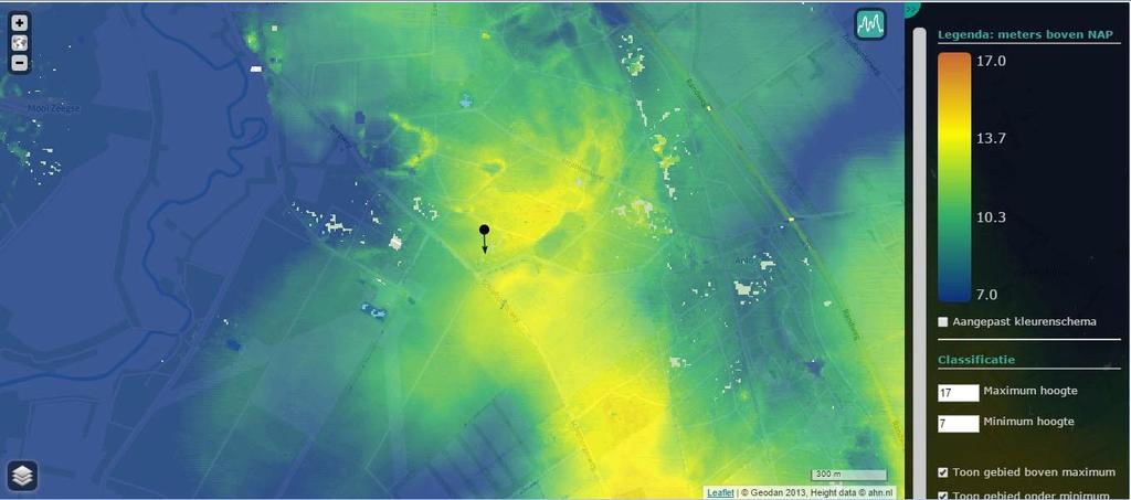
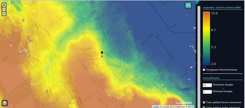
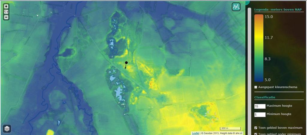
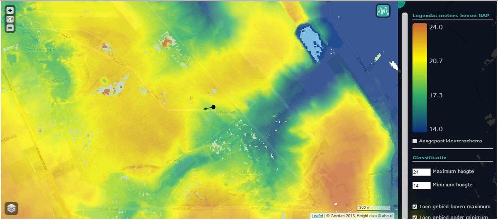
3 were visible and in this way the monuments were linked to specific sectors in the landscape (Oswald et al., 2001: 106). Secondly, monuments change the surroundings of the location in which they are built and add a layer of symbolism to it. Bradley (2000: 104) askes the question what do monuments do to the places where they are built? The first is that the construction of a monument on a place already significant, changes the entire experience of a location (Bradley, 2000: 104). A construction creates restriction and boundaries and thus creates zones for activities (Bradley, 2000: 105). A second way in which monuments change places is the scale on which they were built (Bradley, 2000: 106). Many people were drawn in the construction monuments and therefore they gained a close relationship with these locations. Not only were monuments dominating through their location, but while under construction, they also dominated daily life (Bradley, 2000: 106). A third characteristic of monuments, is that they add additional layers of symbolism to the natural landscape (Bradley, 2000: 107). A natural place already loaded with symbolism, for example a peak sanctuary, is made even more special by, for instance, a building with ornamentation (Bradley, 2000: 107). These three characteristics show that monuments can be used to order the natural landscape and the lives of the people building and using the monuments. Thirdly, the landscape is ordered by the presence of monuments. Richards (1996a; 1996b) discusses henge monuments and the relation with their surrounding landscape. He explains that humans have the tendency to order their world (Richards, 1996a: 315). Because the natural landscape is part of that world, it takes part in the ordering system. The Stones of Stenness and the Ring of Brodgar are used as examples of monuments that order the landscape (Richards, 1996b: 205). Both monuments represent their surrounding topography and are therefore a method to order nature (Richards, 1996b: 205, 193). And finally, monuments serve as means of transformation. This is discussed by Fowler and Cummings (2003) in their study on Neolithic megaliths in the Irish Sea area and their relation to stone and water. They suggest that there was a metaphorical association between water and stone in the Neolithic of the Irish Sea area. This association was centred on practices of transformation (Fowler & Cummings, 2003: 2). Most megalithic sites in the eastern Irish Sea area have views on the sea. They argue that the megalithic chambers created a connection between the sea and stone structures, like the mountains (Fowler & Cummings, 2003: 2-3). They also state that apart from the megaliths along the Irish Sea area, megalithic monuments throughout Europe were involved in rites transforming the human body after death (Fowler & Cummings, 2003: 8). An indication for these rites is the presence of partial human remains, which are found in the Dutch megaliths as well. The landscape setting of Dutch megaliths Methods Each of the Dutch megaliths was plotted on an elevation map of the Netherlands: the AHN1. The AHN1 was chosen, instead of the AHN2 which is more precise, because it gives a more general overview of the relief in the landscape. Each megalith was plotted on its own elevation map of approximately 3300x2000 metres, with a scale of 5 metres above and 5 metres below the height of the location of the megalith. Thus, each map has a different minimum and maximum height, but maintain the same vertical scale. This was done to enhance height differences and improve recognisability of differences in elevation. Megaliths are marked with a spot in the middle of each map and an arrow to indicate the direction in which the entrance of the megalith is facing. These directions were duplicated from an overview of megalith orientation made by Bom (1978: 10). Groups of megaliths are plotted on the same map, and megaliths which are not the subject of the map, but still lie within the map borders, are shown as well. Fig. 3. Examples of megaliths located on north, east, south and west flank. 3
. The grey megalith is on the flank. Fig. 5.")
.")
4 Roelien Rap Fig. 4. Schematic representation of a flank from a cover-sand ridge. The green house is on the highest part of the ridge. The red axe is in the lowest part of the landscape, on the bottom of the ridge (Wiersma & Raemaekers, 2011). The grey megalith is on the flank. Fig. 5. Percentage of Dutch megaliths, per compass direction of flanks. The megaliths were then classified. After it became apparent that all megaliths are situated on flanks, four groups were made: north, east, south and west flank (figure 3). After allocating a megalith in one of these four groups, a further distinction was made: whether the entrance is facing an elevation ( high ) or a depression ( low ). Because some of the entrances are facing parallel to the ridge, another category was added called parallel. If the megaliths were not intentionally placed with the entrance facing a certain way, every direction would take up 25% (figure 4). This means the category parallel would take up 50%, because the entrance can face two ways parallel to the ridge. Results When all Dutch megaliths were plotted on elevation maps, 38 maps were produced (appendix 1). Their location and orientation are presented in table 1. The difference between the compass directions of the flanks is not striking (figure 5). A χ 2 test was executed to calculate if the observed values differ significantly from the expected values. The outcome, 2.547, indicates there is no statistical evidence for a preferred orientation in relation to the landscape setting 1. The differences in entrance direction seem more outspoken (figure 6). 1 The χ2 was calculated using Yates correction (Yates, 1934) on account of the small number of observations (less than 30 per cell): This calculation resulted in a χ2 of At 3 degrees of freedom (n rows - 1: 4-1=2), the value of the χ2 had to be at least to pass the α of Instead, the α lies between 0.1 and 0.9, which means there is a significant chance that the location of the megaliths is random Fig. 6. Percentage of Dutch megalith entrances facing different elevations. For these results a χ 2 test was executed as well. The outcome of means that there is a chance of less than 0.5% that the placement of the entrance of the megaliths is due to chance 2. In other words, there is a preference for certain parts of the landscape. Referring back to figure 4, almost half of the Dutch megaliths are facing the lower areas, the landscape part associated with deposition. Still, the percentage of Dutch megaliths facing the higher parts, associated with settlements, is considerable as well. Discussion It was researched whether the scale and size of the map influenced the classification. When more of the 2 Again using Yates correction (Yates, 1934), this calculation resulted in a χ2 of At 2 degrees of freedom (n rows - 1: 3-1=2), the value of the χ2 had to be at least to pass the α of
5 Table 1. Dutch megaliths and their location on a ridge and in which direction the entrance is facing. Flank Direction Entrance Direc. Flank Direction Entrance Direc. Megalith North East South West High Parallel Low Megalith North East South West High Parallel Low D1 x x D28 x x D2 x x D29 x x D3 x x D30 x x D4 x x D31 x x D5 x x D32 x x D6 x x D34 x x D7 x x D35 x x D8 x x D36 x x D9 x x D37 x x D10 x x D38 x x D11 x x D39 x x D12 x x D40 x x D13 x x D41 x x D14 x x D42 x x D15 x x D43 x x D16 x x D44 x x D17 x x D45 x x D18 x x D46 x x D19 x x D47 x x D20 x x D49 x x D21 x x D50 x x D22 x x D51 x x D23 x x D52 x x D24 x x D53 x x D25 x x D54 x x D26 x x G1 x x D27 x x Table 2. percentage of megaliths per classification. In the columns different map sizes are shown in metres. Megaliths % Scale 100* * * *2000 Flank North East South West Entrance High Parallel Low surroundings are visible on the map, classification is based on the landscape visible on the map. To determine how much of an influence the map size was, overlays were made with different sizes: 100x100 metres, 300x300 metres and 1000x1000 metres. Every megalith was placed in the centre of the smaller frame and classified again (table 2). With a scale of 1000x1000 results do not differ much from the results of this research. If anything, the differences are more extreme. In the smaller map sizes the class Parallel is much higher than in the larger sizes. This is mainly because with a small map it is difficult to assess the course of a ridge. Despite the small differences in results with the other map sizes, a larger map size gives a more reliable result. This way it is possible to see the general flow of the landscape and to see extremes in the 5
6 Roelien Rap Fig. 7. Schematic representation of an FBC landscape. The green house represents the settlements in the higher dry areas. The megaliths in grey are located on the flanks of ridges. The lower areas contain depositions, like axes (in red). landscapes that are further away, but would have been noticeable for FBC people as well. Conclusion The Dutch megalithic monuments were part of a landscape created by nature and humans. The natural environment was a significant influence on the choices people made in the organisation of the landscape. They are built on a place in the landscape, which is already special: the flanks of ridges. By building a megalithic grave monument on this location, an additional layer of symbolism was added and the experience of the location changed. With the construction of the megaliths on flanks of ridges, a border between high and low, dry and wet, living and divine was created and the landscape was ordered. In figure 7 the ordering of the FBC landscape is depicted. In the high and dry area, settlements are located. The settlements are either restricted or connected from the lower deposition area by the megalithic monument. But the Dutch megaliths seem to have fulfilled a more specific purpose. It has been established that half of all Dutch megaliths have an entrance facing a low area. This means that these megaliths are facing the higher parts of the landscape with their closed back. From the settlement area, people would have to go around an enormous earthen monument to reach the divine landscape. This monument does not only have the role to impress, but also to commemorate the dead (Scarre, 2011: 9). With its size and meaning the megalithic monument orders the landscape and could have a role of transformation between the place of the living (the settlement area) and the place of the divine (the deposition area). References Bakker, J.A., The Dutch Hunebedden. Megalithic tombs of the Funnel Beaker Culture. Michigan: International Monographs in Prehistory. Bakker, J.A. & W. Groenman-van Wateringe, Megaliths, soils and vegetation on the Drenthe Plateau. In: Groenman-van Wateringe, W. & M. Robinson (eds.). Man-made soils, pp Oxford: B.A.R. Bom, F., Het mysterie van de hunebedden. Buitenaardse hulp? Deventer: Uitgeverij Ankh- Hermes BV. Bradley, R., An Archaeology of Natural Places. London: Routledge. Brindley, A.L., Hunebed G2: Excavation and finds. Palaeohistoria 28, pp Fowler, C. & V. Cummings, Places of Transformation: Building Monuments from Water and Stone in the Neolithic of the Irish Sea. The Journal of the Royal Anthropological Institute 9:1, pp Ginkel, L., van, S. Jager & W. van der Sanden, Hunebedden, Monumenten van een Steentijdcultuur. Abcoude: Uitgeverij Uniepers. Midgley, M., TRB Culture. The First Farmers of the North European Plain. Edinburg: University Press. Oswald, A., C. Dyer & M. Barber, The Creation of Monuments. Neolithic Causewayed enclosures in the British Isles. Swindon: English Heritage. Raemaekers, D.C.M. & J.J. Wiersma, Over de plaats van leven en dood in het neolithicum. Een landschapsbenadering van de trechterbekercultuur in Drenthe. In: M.J.L.Th. Niekus (ed.): Gevormd en ongevormd landschap. Van prehistorie tot Middeleeuwen, pp Drents Prehistorische Vereniging. Richards, C., 1996a. Henges and Water: Towards an Elemental Understanding of Monumentality and Landscape in Late Neolithic Britain. Journal of Material Culture 1:3, pp Richards, C., 1996b. Monuments as Landscape: Creating a Centre of the World in Late Neolithic Orkney. World Archaeology 28:2, pp Scarre, C., Monumentality. In: T. Insoll (ed.) Oxford Handbook of the Archaeology of Ritual and Religion, pp Oxford: Oxford University Press. Spek, T., Het Drentse esdorpenlandschap. Een historisch-geografische studie. Utrecht: Uitgeverij Matrijs. Trigger, B.G., Monumental Architecture: A thermodynamic Explanation of Symbolic Behaviour. World Archaeology 22:2, pp Whittle, A.W.R., Europe in the Neolithic: The Creation of New Worlds. Cambridge: Cambridge University Press. Yates, F., Contingency Tables Involving Small Numbers and the χ 2 Test. Journal of the Royal Statistical Society 1, pp AHN viewer. Available at: [Accessed 17 May 2015]. Author Roelien Rap roelienrap@gmail.com 6


7 Appendix 1 Megalith D1 Map D2 D3 -D4 (left to right) 7


8 Roelien Rap D5 D6 D7 8

9 D8 D9 D10 9

 D14")
10 Roelien Rap D11 D12-D13 (left to right) D14 10
")
")

11 D15 D16 D17 (top) - D18 (bottom) 11

")

12 Roelien Rap D19 D20 (left to right) D21-D25 (left to right) D26 12
")

13 D27 (left) D28 (middle) D29 (right) D28 (middle) D29 (right) D27 (left) D30 13


14 Roelien Rap D31 D32 D34 14


")
15 D35 D36 - D37 (left to right) D38 D40 (top to bottom) 15
 D42 (middle")
 D41 (top)")
 D41 ) 16")
16 Roelien Rap D41 (top) D42 (middle D43 (bottom) D42 (middle) D41 (top) D43 (bottom) D43 (bottom) D41 (top) D42 (middle) 16
 D43")
 D41")
")
17 D44 (bottom) D42 (top) D43 (middle) D45 (bottom) D41 (top) D43 (middle) D46 D47 (top to bottom) 17


18 Roelien Rap D49 D50-D51 (top to bottom) D52 18


19 D53 D54 (left to right) G1 19
EHER 9194 Field to South of Sewage Works at Bures St Mary National Grid Ref: TL919333
 EHER 9194 Field to South of Sewage Works at Bures St Mary National Grid Ref: TL919333 Background Situated to the South of the Sewage works and North of a bend in the river Stour. The Tithe Award Map of
MOUNDS IN VERMONT: PREHISTORIC OR HISTORIC?
 MOUNDS IN VERMONT: PREHISTORIC OR HISTORIC? WILLIAM A. HAVILAND University of Vermont Revised 1973 Vermont Archaeological Society Monograph Series: Number 2 Vermont Archaeological Society c/o Waterman
Lines in the Landscape
 Cursus monuments in the Upper Thames Valley: excavations at the Drayton and Lechlade cursuses by Alistair Barclay, George Lambrick, John Moore and Mark Robinson with contributions by Leigh Allen, Kathy
T.J. Ferguson. A Hopi itaakuku (footprint) near Flagstaff, Arizona.
 near Flagstaff, Arizona.") T.J. Ferguson A Hopi itaakuku (footprint) near Flagstaff, Arizona. 24 VOLUME 46, NUMBER 2 EXPEDITION Hopi Ancestral Sites and Cultural Landscapes BY LEIGH J. KUWANWISIWMA AND T. J. FERGUSON HOPITUTSKWA
T.J. Ferguson A Hopi itaakuku (footprint) near Flagstaff, Arizona. 24 VOLUME 46, NUMBER 2 EXPEDITION Hopi Ancestral Sites and Cultural Landscapes BY LEIGH J. KUWANWISIWMA AND T. J. FERGUSON HOPITUTSKWA
Cultural Differences in the United Kingdom & Ireland
 Your web browser (Safari 7) is out of date. For more security, comfort and Activitydevelop the best experience on this site: Update your browser Ignore Cultural Differences in the United Kingdom & Ireland
SERPENT MOUND. Teacher Background
 Learning Objectives Students will learn about the late prehistoric Indians and their cultural practices by studying the Fort Ancient Indian culture and the giant earthwork Serpent Mound. Lesson Overview
Stonehenge And Avebury: Exploring The World Heritage Site - 1: Scale (English Heritage Maps) READ ONLINE
 READ ONLINE") Stonehenge And Avebury: Exploring The World Heritage Site - 1:10 000 Scale (English Heritage Maps) READ ONLINE If you are looking for the book Stonehenge and Avebury: Exploring the World Heritage Site
Stonehenge And Avebury: Exploring The World Heritage Site - 1:10 000 Scale (English Heritage Maps) READ ONLINE If you are looking for the book Stonehenge and Avebury: Exploring the World Heritage Site
2013 NRC Regular Category BOROBUDUR SHRINE RESTORATION
 1 2013 NRC Regular Category Lower Secondary School Game description, rules, & scoring BOROBUDUR SHRINE RESTORATION 2 1. Prelude Borobudur, or Barabudur, is a 9th-century Mahayana Buddhist monument in Magelang,
Modern World History Honors Summer Assignment
 Modern World History Honors Summer Assignment Summer 2018 Welcome to Honors World History! The summer assignment below is designed to help you prepare for the exciting year ahead. This summer assignment
International Boundary Study. Jordan Saudi Arabia Boundary
 International Boundary Study No. 60 December 30, 1965 Jordan Saudi Arabia Boundary (Country Codes: JO-SA) The Geographer Office of the Geographer Bureau of Intelligence and Research INTERNATIONAL BOUNDARY
Probability Distributions TEACHER NOTES MATH NSPIRED
 Math Objectives Students will compare the distribution of a discrete sample space to distributions of randomly selected outcomes from that sample space. Students will identify the structure that emerges
The origins of Stonehenge: new discoveries and fresh perspectives
 The origins of Stonehenge: new discoveries and fresh perspectives Start date 12 th February 2017 End date 13 th February 2017 Venue Madingley Hall Madingley Cambridge Tutor Professor David Jacques Course
Archaeology of Mother Earth Sites and Sanctuaries through the Ages
 Archaeology of Mother Earth Sites and Sanctuaries through the Ages Rethinking symbols and images, art and artefacts from history and prehistory Edited by G. Terence Meaden BAR International Series 2389
Architecture of the Muttodaya Stúpa
 Architecture of the Muttodaya Stúpa Why build a stúpa? The German Buddhist forest monastery Muttodaya, situated in the Frankonian Forest near Stammbach, district Hof, was inaugurated on Vesakh day, the
ST NICHOLAS CHURCH, ORPHIR
 Property in Care (PIC) ID: PIC319 Designations: Scheduled Monument (SM13379) Taken into State care: 1952 (Ownership) Last reviewed: 2004 HISTORIC ENVIRONMENT SCOTLAND STATEMENT OF SIGNIFICANCE ST NICHOLAS
The Cave of John the Baptist Published August 17, 2004
 The Cave of John the Baptist Published August 17, 2004 Some things to note regarding John the Baptist: Matthew 3:4 4 And the same John had his raiment of camel's hair, and a leathern girdle about his loins;
Religious Practices and Cult Objects during the Iron Age IIA at Tel Reh.ov and their Implications regarding Religion in Northern Israel
 Amihai Mazar Religious Practices and Cult Objects during the Iron Age IIA at Tel Reh.ov and their Implications regarding Religion in Northern Israel This article presents evidence relating to religious
1 DAVID DAVIS. ANDREW MARR SHOW, 12 TH MARCH 2017 DAVID DAVIS, Secretary of State for Exiting the EU
 ANDREW MARR SHOW, 12 TH MARCH 2017, Secretary of State for Exiting the EU 1 AM: Grossly negligent, Mr Davis. DD: Good morning. This is like Brexit central this morning, isn t it? AM: It really is a bit
On saving memory. The Jewish Cemetery on Gwarna Street in Wroclaw, Poland. Agnieszka Jablonska. 2 nd August 2017
 On saving memory The Jewish Cemetery on Gwarna Street in Wroclaw, Poland Agnieszka Jablonska Fellow at the European Institute for Jewish Studies in Sweden - Paideia & B.A. student in Jewish Studies, University
AS-LEVEL Archaeology. ARCH1 The Archaeology of Religion and Ritual Report on the Examination June Version: 1.0
 AS-LEVEL Archaeology ARCH1 The Archaeology of Religion and Ritual Report on the Examination 2010 June 2015 Version: 1.0 Further copies of this Report are available from aqa.org.uk Copyright 2015 AQA and
Prehistoric Britain small group history tour including standing stones
 Reading List Standing Stones by Beth Camp In 1842, Lord Gordon claims his new estate in Northern Scotland and plans to replace farmers and fishermen with sheep. Mac McDonnell, suspicious of Lord Gordon
Laser Technology Uncovers Secrets at Stonehenge
 Laser Technology Uncovers Secrets at Stonehenge Stonehenge is still a place of ceremony. Last year, Michael Johnson was photographed with the Olympic torch at the stone circle before the London Olympic
Where in the world? Mesopotamia Lesson 1 The Sumerians ESSENTIAL QUESTION. Terms to Know GUIDING QUESTIONS
 Lesson 1 The Sumerians ESSENTIAL QUESTION How does geography influence the way people live? GUIDING QUESTIONS 1. Why did people settle in? 2. What was life like in Sumer? 3. What ideas and inventions did
Religion and Geography
 EX 4: Associated Images of the Visualization is when we form or recall mental images. Iconic image is a generalized representation of an area, using a famous or wellknown example to associate with it.
Europe s Cultures Teacher: Mrs. Moody
 Europe s Cultures Teacher: Mrs. Moody ACTIVATE YOUR BRAIN Greece Germany Poland Belgium Learning Target: I CAN describe the cultural characteristics of Europe. Cultural expressions are ways to show culture
Who Built Stonehenge?
 Who Built Stonehenge? By History.com, adapted by Newsela staff on 08.22.17 Word Count 1,044 Level 1220L Stonehenge is one of the most famous places in the world. How it got there and what it was used for
INDIRA GANDHI NATIONAL CENTRE FOR THE ARTS Janpath, New Delhi ,
 INDIRA GANDHI NATIONAL CENTRE FOR THE ARTS Janpath, New Delhi -110 001, www.ignca.gov.in Documentation format for Archaeological / Heritage Sites / Monuments Serial No.: OR / KDA/ BSR- 235 1. Name SECTION
netw rks Where in the world? When did it happen? Mesopotamia Lesson 1 The Sumerians ESSENTIAL QUESTION Terms to Know GUIDING QUESTIONS
 NAME DATE CLASS Lesson 1 The Sumerians Terms to Know ESSENTIAL QUESTION silt small particles of fertile soil irrigation a way to supply dry land with water through ditches, pipes, or streams surplus an
Knights of Columbus-Marist Poll January 2011
 How to Read Banners Banners are a simple way to display tabular data. The following provides an explanation of how to read the banners. 1. Thinking of the entire table as a grid of cells, each cell contains
STI 2018 Conference Proceedings
 STI 2018 Conference Proceedings Proceedings of the 23rd International Conference on Science and Technology Indicators All papers published in this conference proceedings have been peer reviewed through
Analyzing the activities of visitors of the Leiden Ranking website
 Analyzing the activities of visitors of the Leiden Ranking website Nees Jan van Eck and Ludo Waltman Centre for Science and Technology Studies, Leiden University, The Netherlands {ecknjpvan, waltmanlr}@cwts.leidenuniv.nl
EASTER AQUHORTHIES STONE CIRCLE
 Property in Care (PIC) ID: PIC242 Designations: Scheduled Monument (SM90126) Taken into State care: 1963 (Guardianship) Last reviewed: 2003 HISTORIC ENVIRONMENT SCOTLAND STATEMENT OF SIGNIFICANCE EASTER
Indian Megalithic Culture
 Course Name: PREHISTORIC ARCHAEOLOGY Paper No. & Title: B.A. / B.Sc. (Honours) 5 TH Semester (Theory) Topic No. & Title: (20/21) Indian Megalithic Culture 1. Introduction Megalithic culture, it is often
HELD IN TURKU AUGUST 26-30, Excursions. At the Conference on Church Archaeology in the Baltic Sea Region
 HELD IN TURKU AUGUST 26-30, 2013 Excursions At the Conference on Church Archaeology in the Baltic Sea Region Text and Photos by Markus Hiekkanen if not mentioned otherwise. Plans: In Hiekkanen, Markus
THERE is an obvious need for accurate data on the trend in the number of. in the Republic of Ireland, BRENDAN M. WALSH*
 Trends in the Religious in the Republic of Ireland, Composition of the Population BRENDAN M. WALSH* Abstract: Compared with 1946 there were more Catholics in the Republic in 1971 but 24 per cent fewer
The use and arrangement of space at Meteora (1960 to present)
") CHAPTER 10 The use and arrangement of space at Meteora (1960 to present) 10.1. Overview The changing wider circumstances of the operation of the site over time, namely the growth of the tourism and heritage
CHAPTER 10 The use and arrangement of space at Meteora (1960 to present) 10.1. Overview The changing wider circumstances of the operation of the site over time, namely the growth of the tourism and heritage
HELD IN TURKU AUGUST 26-30, Excursions. At the Conference on Church Archaeology in the Baltic Sea Region
 HELD IN TURKU AUGUST 26-30, 2013 Excursions At the Conference on Church Archaeology in the Baltic Sea Region Online version with more photos. Text and Photos by Markus Hiekkanen, if otherwise not mentioned.
A Potentially Significant Dimension Recorded on an Old Kingdom Papyrus from Saqqara
 The Journal of Ancient Egyptian Architecture vol. 2, 2017 A Potentially Significant Dimension Recorded on an Old Kingdom Papyrus from Saqqara Colin Reader Cite this article: C. Reader, A Potentially Significant
CEMETERY RULES AND REGULATIONS
 Preamble. To be absent from the body, and to be present with the Lord. 2 Corinthians 5:8 CEMETERY RULES AND REGULATIONS St. Paul s Evangelical Lutheran Cemetery, California, Missouri Evangelical Lutheran
1.2. What is said: propositions
 1.2. What is said: propositions 1.2.0. Overview In 1.1.5, we saw the close relation between two properties of a deductive inference: (i) it is a transition from premises to conclusion that is free of any
The Geographic and Political Situation at the Time of Christ s Ministry
 3 The Geographic and Political Situation at the Time of Christ s Ministry Whenever some students see the word geography, they cringe, thinking that the subject is boring and impractical. In reality, geography
Holiday Reflections: the twelve days of Christmas.
 Holiday Reflections: the twelve days of Christmas. A SECULAR APPLICATION DR LESLEE BROWN Introduction Welcome to our course and journey into the symbolic and personal meaning of the twelve days of Christmas.
Love of Nature and Life
 Love of Nature and Life Louis Laganà analyses some of the works of ceramic-artist Sina Farrugia Micallef who is inspired by Neolithic imagery and Nature Maltese Neolithic art is full of symbolism which
The SELF THE SELF AND RELIGIOUS EXPERIENCE: RELIGIOUS INTERNALIZATION PREDICTS RELIGIOUS COMFORT MICHAEL B. KITCHENS 1
 THE SELF AND RELIGIOUS EXPERIENCE: RELIGIOUS INTERNALIZATION PREDICTS RELIGIOUS COMFORT MICHAEL B. KITCHENS 1 Research shows that variations in religious internalization (i.e., the degree to which one
HSC EXAMINATION REPORT. Studies of Religion
 1998 HSC EXAMINATION REPORT Studies of Religion Board of Studies 1999 Published by Board of Studies NSW GPO Box 5300 Sydney NSW 2001 Australia Tel: (02) 9367 8111 Fax: (02) 9262 6270 Internet: http://www.boardofstudies.nsw.edu.au
The Prehistoric Temples Of Stonehenge And Avebury By R.J.C. Atkinson READ ONLINE
 The Prehistoric Temples Of Stonehenge And Avebury By R.J.C. Atkinson READ ONLINE If searched for the book by R.J.C. Atkinson The Prehistoric Temples of Stonehenge and Avebury in pdf form, then you've come
SWOT Analysis Religious Cultural Tourism
 SWOT Analysis Religious Cultural Tourism Religious Cultural Assets Potential Partner: NERDA Released: July 9 th 2012 SWOT Analysis What is the SWOT Analysis It s an analysis support to the choices and
Interpretation of the questionnaire results
 cocenval-cint Evaluation Interpretation of the questionnaire results Chapter C Behavioural attitudes By : Rainer Hampel 1. Preliminary consideration Many psychological and sociological studies have shown
INDIRA GANDHI NATIONAL CENTRE FOR THE ARTS Janpath, New Delhi ,
 INDIRA GANDHI NATIONAL CENTRE FOR THE ARTS Janpath, New Delhi -110 001, www.ignca.gov.in Documentation format for Archaeological / Heritage Sites / Monuments Serial No.: OR / KDA / BSR 245 1. Name SECTION
Masonic Tracing Boards and the Western Metaphysical Tradition. W. Kirk MacNulty
 top of page Masonic Tracing Boards and the Western Metaphysical Tradition W. Kirk MacNulty Introduction Masonic Tracing Boards are training devices. They depict Masonic symbols in pictures which can be
Report about the Latest Results of Precipitation Verification over Italy
 5 Working Group on Verification and Case Studies 37 Report about the Latest Results of Precipitation Verification over Italy Elena Oberto, Marco Turco ARPA PIEMONTE, Torino, Italy 1 Introduction In the
Mission and Strategy Isaan Teams Sowing Seed to Plant Indigenous Churches
 Mission and Strategy Isaan Teams Sowing Seed to Plant Indigenous Churches When He saw the crowds, He had compassion on them, because they were harassed and helpless like sheep without a shepherd (Matthew
HISTORY OF IRELAND (EVOLUTION OF MODERN IRELAND) CAS HI 325 / PO 381
 CAS HI 325 / PO 381") HISTORY OF IRELAND (EVOLUTION OF MODERN IRELAND) CAS HI 325 / PO 381 Lecturer: Ms. Caroline Connolly MA Email: caroline.connolly26@mail.dcu.ie (emails will be answered 9am-6pm Mon.-Fri.) Course Overview
HISTORY OF IRELAND (EVOLUTION OF MODERN IRELAND) CAS HI 325 / PO 381 Lecturer: Ms. Caroline Connolly MA Email: caroline.connolly26@mail.dcu.ie (emails will be answered 9am-6pm Mon.-Fri.) Course Overview
Perception about God and Religion within the Malaysian Society
 Doi:10.5901/mjss.2015.v6n1s1p246 Abstract Perception about God and Religion within the Malaysian Society Mohd Arip Kasmo 1 Abur Hamdi Usman 2* Zulkifli Mohamad 1 Nasruddin Yunos 1 Wan Zulkifli Wan Hassan
NOTES FURTHER NOTES ON PRASAT MUANG SINGH, KANCHANABURI PROVINCE. M.C. Subhadradis Diskul
 NOTES FURTHER NOTES ON PRASAT MUANG SINGH, KANCHANABURI PROVINCE M.C. Subhadradis Diskul In the Journal of the Siam Society Vol. 66 Pt. 1, January 1978, the writer wrote on recent excavations at Prasat
USE PATTERN OF ARCHIVES ON THE HISTORY OF MYSORE
 USE PATTERN OF ARCHIVES ON THE HISTORY OF MYSORE N. Chowdappa, 1 L. Usha Devi 2 and C.P.Ramasesh 3 ABSTRACT Records on the Administration of the Princely State of Mysore and Mysore History form rare collections
The Puzzling Pool of Bethesda
 The Puzzling Pool of Bethesda By Urban C. von Wahlde The Gospel of John recounts two healing miracles Jesus performed in Jerusalem. In one, Jesus cured a man who had been blind from birth. Jesus mixed
Early Civilizations Review
 Early Civilizations Review An area with common physical features is called a. region The study of the ways of past cultures through the items they left behind is. archaeology The practice of worshipping
Britain Bc Life In Britain And Ireland Before The Romans
 We have made it easy for you to find a PDF Ebooks without any digging. And by having access to our ebooks online or by storing it on your computer, you have convenient answers with britain bc life in britain
Name: Date: Period: #: Chapter 9: Outline Notes Ancient India
 Name: Date: Period: #: Lesson 9.1 Early Civilizations Chapter 9: Outline Notes Ancient India The Geography of India: India and several other countries make up the of India. o A subcontinent is a large
4 To what extent is the divide between public and private life reflected in evidence for public worship in Roman Italy?
 4 To what extent is the divide between public and private life reflected in evidence for public worship in Roman Italy? Megan Lewis (mailto:mhl771@bham.ac.uk) As one of my 2nd year modules, I had to plan
Blurred Lines: The Iconostasis Role In The Eastern Orthodox Church
 Elizabeth Lian Mt. Menoikeion Summer Seminar 16 September 2013 Blurred Lines: The Iconostasis Role In The Eastern Orthodox Church In Eastern Orthodox Christian churches of Byzantine tradition, an opaque
Structural Assessment and Rehabilitation Option for YudaganawaDagoba in Buttala
 Structural Assessment and Rehabilitation Option for YudaganawaDagoba in Buttala H.G.S.R.Kularathna 1, D.N.T.M.Siriwardhana 1, W.N.Sudharshana 1 and C.S.Lewangamage 1 Abstract Yudaganawadagoba in Uva province
Paper A3 Introduction to Ancient Egypt & Mesopotamia:
 Archaeology Tripos, Pt I HSPS Tripos Pt. I PART I Paper A3 Introduction to Ancient Egypt & Mesopotamia: Course Co-ordinator: Dr Augusta McMahon, amm36@cam.ac.uk Lecturers: Dr Augusta McMahon, amm36@cam.ac.uk
LEARNING OUTCOMES Upon the successful completion of this module, the student should:
 MODULE CODE: HPCS4006 TITLE: Celtic Religions DATED: 17/05/2017 LEVEL: 4 CREDITS: 20 JACS CODE: Q500 AIM(S) To enable students to understand, and analyse the evidence for religious concepts and habitual
Running head: Jewish Heritage 1
 Running head: Jewish Heritage 1 History of European-American Jewish Heritage Student s Name Institution s Name Jewish Heritage 2 History of European-American Jewish Heritage European-American Jews are
Considering Importance of Light in the Post- Byzantine Church in Central Albania
 Considering Importance of Light in the Post- Byzantine Church in Central Albania L. Shumka PhD Student, Faculty Of Forest Sciences, Agricultural University of Tirana, Tirana, Albania Abstract: The subject
A Unique Mikveh in Upper Galilee
 A Unique Mikveh in Upper Galilee A mikveh in the Holy Land which shows a cross on its wall. By Eldad Keynan Bar Ilan Israel September 2015 Conventionally, when an ancient mikveh is discovered, we consider
St. Vincent Martyr Church, Madison, NJ
 Design Vision for St. Vincent Martyr Church, Madison, NJ JAMES HUNDT LITURGICAL DESIGN CONSULTANT 426 State Street, 3 rd Floor Schenectady, New York (518) 372-3655 THE EXISTING SPACE The current worship
Decision Report Plan Change 13 Waihi Beach Viewshafts
 Decision Report Plan Change 1 Waihi Beach Viewshafts Important Note The Proposed District Plan May 11 Annotated Version was the current version of the District Plan when Plan Changes 1- were notified in
Tribes and Territories In Transition
 Rijksuniversiteit Groningen Tribes and Territories In Transition The central east Jordan Valley and surrounding regions in the Late Bronze and Early Iron Ages: a study of the sources Proefschrift ter verkrijging
Guidance Note Statements of Significance and Statements of Needs
 Guidance Note Statements of Significance and Statements of Needs This form should be used for all projects other than very complex ones. For major complex projects an expanded version of this form is likely
ADDENDUM. Chain of Title. Tax Map 144, Parcel A
 Chain of Title Tax Map 144, Parcel A HB 1:618 April 18, 1868 JB10:323 March 12, 1900 NLP 7684:913 June 12, 1990 VJ 14547:444 February 26, 2001 Jane P. Williams to Trustees of the African Methodist Episcopal
I. The First Civilizations
 I. The First Civilizations Humans are in the far corners of the globe thriving as hunter-gatherers, however, as time passes the human population explodes decreasing the overall food supply. With food dwindling
Characterization of space around Japanese traditional buildings: transitions of layout plan and meaning of space of darkness inside wooden temples
 Structural Studies, Repairs and Maintenance of Heritage Architecture XI 47 Characterization of space around Japanese traditional buildings: transitions of layout plan and meaning of space of darkness inside
Table of Contents. Our Pennsylvania Story 5
 Table of Contents United States Political Map...........................................2 Pennsylvania Political Map...........................................3 Pennsylvania Physical Map...........................................4
The. Temple Mount. Sifting Project. Anything that happens on the. resonates throughout the world.
 Anything that happens on the Temple Mount resonates throughout the world. The Temple Mount Sifting Project The Temple Mount The Temple Mount is sacred to more than half of the world s population. It is
World Leaders: King Tutankhamun
 World Leaders: King Tutankhamun By Biography.com Editors and A+E Networks, adapted by Newsela staff on 10.13.16 Word Count 837 The golden funerary mask of King Tutankhamun in the Egyptian Museum. Wikimedia
ALABAMA REGISTER OF LANDMARKS & HERITAGE NOMINATION FORM. Historic Name: and/or Common Name:
 ALABAMA REGISTER OF LANDMARKS & HERITAGE NOMINATION FORM 1. NAME OF PROPERTY Historic Name: and/or Common Name: Preferred name for Certificate: Historic Name or Common Name 2. LOCATION Street & Number:
Martin Melck warehouse Built History and Grading
 Martin Melck warehouse Built 1764-1767 History and Grading Brief history (1742 1876) Lutherans were not allowed a church or pastor of their own. Heinrich Hop and others petitioned the VOC from 1742 onwards
Catholic Church is the Divinity Symbol with the Case Study of Santa Theresia Church in Jakarta, Indonesia
 Catholic Church is the Divinity Symbol with the Case Study of Santa Theresia Church in Jakarta, Indonesia Rudy Trisno #1, Fermanto Lianto* 2 # Architecture Department, Tarumanagara University S. Parman
The Maya : Cross-Curricular Topic : Year 3/4
 2 4 5 6 7 History Investigate how and when Europeans encountered the Mayan civilisation. Explore how we know about the Mayan civilisation and their way of life. Explore how Mayan society was organised
Tests of Homogeneity and Independence
 Tests of Homogeneity and Independence Lecture 52 Sections 14.5 Robb T. Koether Hampden-Sydney College Mon, Apr 26, 2010 Robb T. Koether (Hampden-Sydney College) Tests of Homogeneity and Independence Mon,
jpr / Pesach 5774 / April 2014
 jpr/data night Make your seder night different from all other seder nights April 14 jpr / Pesach 5774 / April 14 Institute for Jewish Policy Research Data night Four questions to make your seder night
Gottschall, A Review: Eric H. Cline, Biblical Archaeology. A. Very Short Introduction. Oxford: Oxford University Press 2009.
 Gottschall, A. 2010. Review: Eric H. Cline, Biblical Archaeology. A Very Short Introduction. Oxford: Oxford University Press 2009. Rosetta 8: 117-120. http://rosetta.bham.ac.uk/issue8/reviews/gottschall-cline.pdf
Howard Williams BSc MA PhD FSA
 Howard Williams BSc MA PhD FSA WORK ADDRESS Department of History & Archaeology, University of Chester, Parkgate Road, Chester CH1 4BJ Tel: 01244 512161 Email: howard.williams@chester.ac.uk EDUCATION 2000
Mind the Gap: measuring religiosity in Ireland
 Mind the Gap: measuring religiosity in Ireland At Census 2002, just over 88% of people in the Republic of Ireland declared themselves to be Catholic when asked their religion. This was a slight decrease
The Neolithic Era, or Period, or New Stone age, was a period in the development of human technology, beginning about 10,200 BC, according to the
 The Neolithic Era, or Period, or New Stone age, was a period in the development of human technology, beginning about 10,200 BC, according to the ASPRO chronology in some parts of the Middle East, and later
Citadel of Aleppo. 31 sites. Severely Damaged. Possibly Damaged. Destroyed. Moderately Damaged. Citadel of Aleppo
 Citadel of Aleppo Citadel of Aleppo 31 sites 1 3 21 6 Destroyed Severely Damaged Moderately Damaged Possibly Damaged Aleppo Citadel Entrance. Picture date: 4 April 2010 Bernard Gagnon CITAdEL OF ALEPPO
El- Baramus Monastery of the Virgin Mary Dair El-Baramus in Wadi El Natrun
 El- Baramus Monastery of the Virgin Mary Dair El-Baramus in Wadi El Natrun George Guirguis, St. Mark Church, Houston Tx W adi El Natrun (also known as Scetis) is located just west of the Nile Delta, about
ST MARY OF THE INCARNATION. PARISH PROFILE Living the Gospel. Engaging God s World. Incorporating St Mary the Virgin Heritage Church, Metchosin BC
 PARISH PROFILE Living the Gospel. Engaging God s World. ST MARY OF THE INCARNATION Incorporating St Mary the Virgin Heritage Church, Metchosin BC 4125 Metchosin Road, Victoria British Columbia V9B 5T8
This is an Article for March 2010 An A.S.K. Doctrinal Report
 This is an Article for March 2010 An A.S.K. Doctrinal Report Associates for Scriptural Knowledge P.O. Box 25000, Portland, OR 97298-0990 USA ASK, March 2010 All rights reserved Number 3/10 Telephone: 503
Terrific Archaeologies Of The Contemporary Past
 Terrific Archaeologies Of The Contemporary Past Download: archaeologies-of-the-contemporary-past.pdf Read: archaeologies contemporary past Read & download archaeologies of the contemporary past in rear
CULTURAL (SPATIAL) DIFFUSION (spread of ideas, innovations) two models
 DIFFUSION (spread of ideas, innovations) two models") CULTURAL (SPATIAL) DIFFUSION (spread of ideas, innovations) two models Expansion ideas spread to new places as different cultures adopt idea Has Contagious & Hierarchical Subtypes Relocation ideas spread
CULTURAL (SPATIAL) DIFFUSION (spread of ideas, innovations) two models Expansion ideas spread to new places as different cultures adopt idea Has Contagious & Hierarchical Subtypes Relocation ideas spread
What New Archaeological Discoveries in Jerusalem Relate to Hezekiah?
 What New Archaeological Discoveries in Jerusalem Relate to Hezekiah? An Old Testament KnoWhy1 relating to the reading assignment for Gospel Doctrine Lesson 30: Come to the House of the Lord (2 Chronicles
Chapter II: Environmental Setting
 Section 1. Regional Profiles Chapter II: Environmental Setting The Oneida Lake watershed is situated within the Oswego-Seneca-Oneida Rivers Drainage Basin that drains to Lake Ontario, through the Gulf
Bringing the Gospel to the unreached, unengaged people groups in the Isaan Region, Thailand.
 Frontida Outreach Thailand Kanthararom, Sisaket Province Building bridges for our Lord and Saviour, Jesus Christ frontidaoutreach@gmail.com Bringing the Gospel to the unreached, unengaged people groups
Lesson 1: Geography of South Asia
 Lesson 1 Summary Lesson 1: Geography of South Asia Use with pages 122 127. Vocabulary subcontinent a large region separated by water from other land areas monsoon season the rainy season subsistence farming
CROATIAN ART AND THE WEST: A VENERABLE WITNESS RECALLED
 Vladimir P. GOSS Washington, D.C., USA CROATIAN ART AND THE WEST: A VENERABLE WITNESS RECALLED In 1978, I published an article in the Cahiers archéologiques, (27/1978) entitled The Southeastern Border
HISTORY AND APPRECIATION OF ART FROM 7th AD TO 12th AD
 History and Appreciation of Art (From 7th AD to 12th AD MODULE - 1 2 HISTORY AND APPRECIATION OF ART FROM 7th AD TO 12th AD The Post Gupta period in India is known for the progress in temple architecture