Erda, Ophir and Stockton Reconnaissance Level Surveys 2008 Tooele County, Utah
|
|
|
- Valentine Booth
- 5 years ago
- Views:
Transcription

1 Erda, Ophir and Stockton Reconnaissance Level Surveys 2008 Final Report April 2009 Prepared by Beatrice Lufkin
2 1 Erda, Ophir and Stockton RLS 2008 TABLE OF CONTENTS Statement of Project Objectives Boundaries of the Survey Areas.2 Fieldwork Techniques...3 Brief Outline Histories Erda 1. Early Settlement and Agricultural Expansion ( ) 2. Livestock Boom ( ) 3. Great Depression ( ) 4. Development of the Defense Industries ( ) 5. Out of Period ( ) Stockton 1. Soldiers, Smelters and Early Settlement ( ) 2. Development of the Defense Industries ( ) 3. Out of Period ( ) Ophir 1. Mining Boom Era ( ) 2. Small Scale Mining and Small Town ( ) 3. Out of Period ( ) Summary of Findings 8 Recommendations..12 Bibliography Appendices. Photo sheets Composite Reports Building Lists
3 2 Erda, Ophir and Stockton RLS 2008 Statement of Project Objectives The purpose of the survey was to inventory and document the existing historic buildings in three designated unincorporated communities of Tooele County (Erda, Ophir and Stockton), to update the Tooele County information files in the statewide database of information on historic buildings in Utah 1 created and maintained by the Utah State Historic Preservation Office (SHPO), and to provide recommendations for use by the Tooele County Historic Preservation Commission in preservation efforts within the surveyed area. A Reconnaissance Level Survey also serves to identify buildings and districts that may potentially be eligible for nomination to the National Register of Historic Places, based on visual criteria, either individually or as part of a larger historic district. This documentation will also provide a written and photographic record of the historic buildings that may be demolished or greatly altered in the future as well as to promote preservation of the buildings documented. Boundaries of the Survey Areas The surveys were selective, i.e. only buildings estimated by visual examination to be constructed within the historic period were included. Areas with concentrations of out-of-period buildings were excluded from the survey areas. Aerial maps of the three areas were provided by Tooele County and the specific sections to be surveyed were communicated orally. The area of Erda surveyed is contained roughly within the boundary streets of Airport Road to the west, Bates Canyon Road to the north, Droubay Road to the east and Erda Way to the south. Streets surveyed are listed below. Bates Canyon Road Bryan Road Church Road Clover Cochrane Erda Way Highway (State Road) 36 Liddell Lane Toms Lane Warr Lane The area of Ophir surveyed is located along Main Street or Ophir Canyon Road. Streets surveyed are listed below. Cliff Street Main Street/Ophir Canyon Road Miner/Back Street Moore Avenue 1 The Utah Historic Sites Database, kept in MS Access format. The information in it is available to the public.
4 3 Erda, Ophir and Stockton RLS 2008 The area of Stockton surveyed is located on either side of Utah State Highway 36 (Connor Avenue) with the majority of structures on the east side. Streets surveyed are listed below. Clark Street Connor Avenue Dutch Avenue Grant Avenue Johnson Street Old Country Road Railroad Lane Railroad Street Rogers Street Sheridan Street Sherman Street Silver Avenue Fieldwork Techniques The survey was conducted in accordance with the Utah State Historic Preservation Office (SHPO) Standard Operating Procedures for Reconnaissance Level Surveys, Revised May Reconnaissance Level Survey forms as revised February 2000 were used to record the survey data. The County will provide the final survey maps with structures marked and labeled with approximate locations of properties and addresses. Photographs were taken using a Nikon D50, a digital 35mm single lens reflex camera with an mm lens. CDs with digital jpeg images of the principal buildings with addresses and evaluations will be provided to both the county and the SHPO. In addition, both the county and the SHPO will receive printed copies of the report, photographs, and data sheets. Tooele County prepared the maps and copies will be provided to the SHPO. When possible, the photographs were taken so that two elevations are visible on the primary building. Visible addresses were used whenever possible. If an address was not visible on a building or mailbox, the address was extrapolated from neighboring structures and marked on the survey forms with an asterisk. A question mark is used to denote an approximate address. Buildings documented in the survey are recorded with regard to address, estimated construction date, exterior building materials, height, architectural style and type, original use of the property and the number of existing outbuildings (as well as their contributing or noncontributing status). Each site was photographed and recorded on the survey map. The estimated construction date was verified against county construction date records, when available at the Tooele County Assessors Office. 2 All buildings surveyed were evaluated using criteria developed by the SHPO to indicate age and integrity and assigned a value of A, B, or C. A building receiving an A evaluation must be more than fifty years old, retain its historic integrity and also possibly be considered as either historically or architecturally significant. Buildings with a B designation retain most of their historic integrity but have some modifications that prevent an A evaluation. B buildings may be considered for the National Register of Historic Places as part of a multiple property 2 The County has few construction date records for buildings in Ophir.
5 4 Erda, Ophir and Stockton RLS 2008 submission or a historic district, with corrective action, or based on their historic associations rather than their architectural significance. Buildings with a C designation were built during the historic period but have lost their architectural integrity as a result of intrusive modifications. These alterations may include the application of vinyl or aluminum siding, incompatible additions in terms of scale and massing, removal or enclosure of the front porch or changes in window openings. A C building may not be eligible for the National Register but may have important local historical value in interpreting local development patterns and be listed on a local city or county register. A, B, and C buildings were constructed during the historic period. A and B buildings are eligible as contributing buildings in a historic district. The National Park Service criteria for inclusion in the National Register of Historic Places (1966) state that a property must be at least fifty years old, with some exceptions, to be included. Buildings constructed in 1959 or earlier are considered within the historic period. When buildings have had significant alterations and/or expansions over time it is difficult to make precise visual identification of the original construction date. The date recorded in the survey is based on a visual estimate of the oldest section of the building in cases of expansions or the date found in the Tooele County Assessor s Office records. New wall cladding or siding often obscures revealing architectural details and makes assessment of the initial construction date difficult. Additional research is required to establish the construction date(s). Brief Outline Histories The purpose of the outline histories is to set a context for the architectural resources to be documented. They are not meant to be comprehensive histories of the communities. Unless otherwise noted, the major dates and events come from Blanthorn s A History of Tooele County. Erda 1. Early Settlement and Agricultural Expansion ( ) The first documented non-native settlement of the Erda area began when Ormus E. Bates, a Mormon 3 pioneer from Salt Lake City, came to the rangeland in 1851 to graze cattle herds in the winters. With his sons he built an adobe and log house and surrounded it with three adobe walls as protection against the displaced Goshute Indians. The logs used were from Bates Canyon to the east. Homesteading, mining and the railroad affected the growth of the community, then known as Batesville, during the second part of this period. New farmers came to the area after 1860 when it was opened to homesteading. U.S. Army volunteers stationed at forts in Utah during the Civil War were actively prospecting in the surrounding mountains. The establishment of mining communities following the successful mining claims in Rush Valley and adjacent areas in the Oquirrh Mountains provided a cash market for agricultural products and relative prosperity for 3 LDS or Church of Jesus Christ of Latter-day Saints.
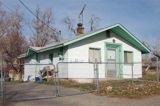
6 5 Erda, Ophir and Stockton RLS 2008 the farmers of the area. The hungry mining communities needed many agricultural products and paid high prices for them. The narrow-gauge Utah-Nevada Western Railroad, begun in 1874 and completed from Lake Point to Bauer in 1883, was built to haul ore from the mines and smelters in Stockton, Ophir and Dry Canyon. The modern SR-36 follows its grade through Erda. 2. Livestock Boom ( ) The livestock industry in Utah changed from the initial Mormon village-based agricultural practice of communal herds to individual private ownership of herds. The incidence of sheep ranching increased greatly in this period with large herds being wintered in the pastures of the Tooele valleys and foraging in the surrounding mountains in the summers. Cattle production began to decrease as sheep were more efficient users of limited pasturelands. Transportation improvements also helped the livestock industry to prosper. A standard gauge railroad, the San Pedro-Salt Lake (later the Union Pacific), passed though the area and located a station in the area. The railroad named the station, Erda, which became the name of the surrounding community. The first transcontinental highway, the Lincoln Highway, passed through Erda on what is now SR-36 until 1927 when the route was changed to a northern path running between Salt Lake City and Wendover. 3. Great Depression ( ) Dust storms and drought in the early 1930s had a devastating effect on agriculture across the country as well as in Erda. The population of the area remained stable at under two hundred people in the 1920, 1930 and 1940 censuses. 4 The Great Depression limited resources available for building. In 1938 when an addition to the Mormon ward house was needed, the schoolhouse was torn down and the bricks from it were used for the ward house addition. 4. Development of the Defense Industries ( ) World War II-related industries and military installations located in Tooele County and Salt Lake County to the east brought employment opportunities and new workers to the Erda area. The Tooele Ordnance Depot (TOD) was built five miles south of Tooele beginning in At its peak it had 5,000 civilian employees and was one of the largest ordnance centers in the west. During World War II it also housed Italian and German prisoners-of-war. 5. Out of Period ( ) Erda residents have convenient access by automobile to businesses and jobs in either Tooele or Salt Lake City. Interstate I-80 was completed through the north section of the County in the 1960s. The airport was built in the 1970s. By 1990 the population was 1,113 and it had more than doubled by the year 2000 to 2,473. Substantial growth has taken place outside of the survey area in new subdivisions but infill and replacement of historic residences will continue to have an impact on the historic survey area. Buildings from this era are, however, not documented or included in the survey. 4 Utah History Encyclopedia, 435.
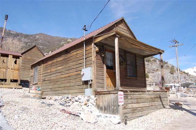
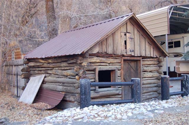
7 6 Erda, Ophir and Stockton RLS 2008 Ophir 1. Mining Boom Era ( ) Colonel Patrick E. Connor, the Father of Utah Mining, and his soldiers from the Third California Infantry Volunteers were sent to the Utah Territory in 1862 during the Civil War to protect the overland mail route across the west. Several of Connor s soldiers noticed the use of metals by the native Goshute peoples and began to search the Rush Valley area to discover the source. Prospecting began and centered on East Canyon in the Oquirrh mountains to the east near the native mines. In 1870 the Ophir Mining District and Ophir Town were organized. By 1871 more than 2,500 mining claims had been staked at Ophir. 5 Silver mines included the Kearsage, the Velocipede, Silveropolis, the Shamrock, Miner s Delight and Wild Delirium. 6 A picture in Harpers magazine in 1874 shows a thriving mining town in the canyon bottom. The population of Ophir reached 6,000 by the mid-1870s. 7 Ore was initially taken to nearby Stockton or Martinsville for processing and shipment by horse cart, a laborious and expensive journey at $1.00 per pound. 8 By the 1880s Ophir had the requisite businesses of a mining town; a hotel, general store, saloons, brothels, a Methodist Church, drug store and livery stable. 9 The veins of ore were rich but shallow and were soon exhausted. By 1900, $13,000,000 in silver had been mined in Ophir mines Small scale mining and small town ( ) As the larger sources of ore ran out the population decreased and remained under 300 inhabitants until 1920 when it surged to 522. It soon dropped back down and by 1960 was 36 people. 11 In 1903 Ophir was incorporated. William Andrew Clark, built a railroad spur, the Clark Railroad, connecting the Ophir mines to Salt Lake City and Rush Valley. Clark was a senator from Montana and the owner of the Ophir Hill Mine. The first train to Ophir was in Out of period ( ) Ophir has been continuously inhabited, but sparsely in the last fifty years. The population has remained in the double digits, ranging from 36 in 1960 to 23 in the 2000 census. With little economic activity during this period, infrequent construction is expected. There is some use of Ophir as a vacation home area so a few newer residences are predicted. Buildings from this era are, however, not included in the survey. In the mid-1980s a resident 13 began to move available older houses to a designated historic area on Moore Avenue. 5 Some Dreams Die, Ibid. 7 The General Plan for the Town of Ophir, II-2. 8 Ibid., II-3. 9 History of Tooele County, Some Dreams Die, Utah History Encyclopedia, History of Tooele County, Telephone conversation with Walt Shubert.
8 7 Erda, Ophir and Stockton RLS 2008 Stockton 1. Soldiers and Smelters ( ) The native Americans of Goshute and Paiute ancestry knew the area near what is now Rush Lake by the name of Shambip. In 1854 Colonel Steptoe brought his U.S. Army soldiers to the shores of Lake Shambip (now Rush Lake) to begin Camp Relief. Colonel Patrick E. Connor is credited with naming the community Stockton, after the California town where he lived before coming to Utah. Connor came to Utah in 1862 with his Third California Volunteers and founded Ft. Douglas. He was visiting Camp Relief in 1864 when the first news of the discovery of precious ores in the surrounding mountains was made. This was the first significant mineral discovery in Utah. 14 Connor named the streets of the town after great generals of the Civil War; Sherman, Grant, etc. The major street is, appropriately, Connor Street, and is also State Highway 36. Industry in Stockton grew in the 1860s and 1870s with the construction of smelters to process ore from the surrounding mines. Connor s Smelter was the first lead-silver smelter in Utah in Others include the Monheim and Johnson built in 1866, the Waterman and Smith Smelter in 1871, the Jack Smelter in 1872 and the Chicago Silver Mining Company Smelter south of town on Rush Lake in There were 103 operating mines and leases in the mountains to the east of town. 16 The first postmaster of Stockton was appointed in The population of Stockton reached a peak of 4,000 in the 1870s. 17 Other community activities were reflected in the buildings constructed. The Stockton Opera House, built in the 1870s, served as a dance hall and community building as well as housing the first school (demolished). A frame Methodist Church was built in 1886 on the northwest corner of Johnson Street and Silver Avenue (demolished). Its land was sold to the school board and the building moved to Main Street and used for a tavern before it burned Community Development ( ) In 1901 the town was incorporated and a number of civic improvements followed. In 1902 the town built a concrete jail (NR, 1985). The first streetlights were installed in The school was moved to a new brick building in 1913 (on the northwest corner of Johnson and Silver Avenue). It was later sold to the LDS Church who used it as a chapel from 1935 until In 1933 a larger school was constructed across the street on the northeast corner of Johnson and Silver Avenue (now Town Hall). Several transportation developments connected Stockton to larger cities. The Oregon Short Line railroad laid tracks to Stockton in 1902 as an extension from Bauer (Terminus). The Stockton depot was built in and the Union Pacific Railroad took over the lines. The Lincoln Highway ran through Stockton on its way from New York to San Francisco from Roper. 15 Stockton s Ghost Towns, Ibid., Ibid., Stockton, A Brief History, Stockton, A Brief History, 51
9 8 Erda, Ophir and Stockton RLS 2008 until 1927 when the route of the highway was diverted on the north from Salt Lake City to Wendover, skipping Tooele and Stockton Development of the Defense Industry ( ) Utah hosted a number of military and industrial facilities in the early years of World War II. Stockton was located between two large ones. The Tooele Ordnance Depot (TOD) was built five miles south of Tooele beginning in At its peak it had 5,000 civilian employees and was one of the largest ordnance centers in the west. South of Stockton the Deseret Chemical Depot was built in Rush Valley in the early years of World War II. Both facilities provided jobs for Stockton inhabitants. The Stockton Fire Department was organized in Out of historic period ( ) The modern era in Stockton began with the dismantling and removal of the Union Pacific Railroad Depot in In 1984 the children of Stockton were bused to Tooele to school and in the 1990s the old school building became the town hall. 21 People in town continue to work at the two nearby government depots although there were defense cutbacks in the early 1990s. Population was fairly stable during this period, remaining around 400; at the 2000 census it was 443. Stockton retains its small town life with a gas station, café, church, town hall, post office and fire station. Buildings from this era are, however, not included in the survey. Summary of Findings Much of the existing previous research on historic buildings in the survey areas was conducted as part of cultural resource surveys for the Utah Department of Transportation in connection with highway improvements to the SR-36 corridor. All statistics are calculated on only the contributing buildings, i.e. those that retain their architectural integrity (A or B buildings). Erda A total of fifty buildings in Erda were documented and two previously surveyed buildings have been demolished. Of the fifty surveyed, twenty-four are eligible/contributing or eligible/significant. The majority of buildings surveyed are residential with the exception of the rodeo grounds, the drive in theater, Virg s restaurant and the Clegg barn. 1. Early Settlement and Agricultural Expansion ( ) Only one building in the survey area is known to date from this era. It is the two-story Greek Revival stone farmstead built by Moses Warr on 528 W. Clover Avenue c Any early adobe and log structures from this era will most likely have been subsequently covered by some type of siding or brick, heavily modified, or used as agricultural outbuildings and not necessarily subject to visual identification. 2. Livestock Boom ( ) 20 Stockton s Ghost Towns Ibid., 2.
10 9 Erda, Ophir and Stockton RLS 2008 The largest group of historic buildings, ten or 42%, are estimated to date from this period. This was a time of relative affluence for Erda farmers and is reflected in the construction of larger houses and agricultural outbuildings to deal with the increased farming activities. Many of the farmsteads have been subdivided for residential construction. The Weyland homestead at 610 Church Road is a single story frame crosswing vernacular classical style c house surrounded by farmlands. Its outbuildings no longer remain and the house is vacant. The Droubay house is a two-and-a-half story 1913 Prairie School-style brick foursquare at 1185 East Erda Way. The Weyland Farmstead is a single-story brick bungalow built in 1920 with a number of agricultural outbuildings. It is also vacant. The c dilapidated Clegg Barn is visible from Highway 36 and has contributing agricultural outbuildings nearby but the primary residence has been demolished and replaced. There are five bungalows built in this era and they include a clip gable example at 159 W. Bates Canyon Road and a Prairie School-style bungalow at 4591 N. Cochrane. 3. The Great Depression ( ) A single building was found to be constructed during the Depression era. It is a brick clipped gable cottage built in at 1563 W. Erda Way. 4. Development of the Defense Industry ( ) Fifty per cent (or twelve) of the primary buildings date from this period, reflecting the population growth in Erda during this time. The Minimal Traditional and other World War II and Post-war residential styles dominate. The houses are primarily one story, of modest size with minimal detailing. Examples are 1478 W. Erda Way (1948) and nearby at 1260 W. Erda Way (1950). Early ranch styles are seen at 678 W. Erda Way (1942) and 4820 N. Toms Lane (1956). A few non-residential structures date from this period. The drive-in theater was initially constructed during this era, 1947, although elements of it have been modified or replaced in the last era. The Erda Arena and Stables was built c Out of period ( ) An LDS ward house and a commercial structure were built during this period but most of the construction has been residential structures. They are replacements for or additions to existing houses as well as additional houses as either infill or on the edge of the town. Buildings from this era are, however, not included in the survey. Ophir Thirty-three structures from the historic era were identified in Ophir. Twenty-seven are eligible/contributing or eligible/significant. Of these, twenty-one are residential. Current numbering on Ophir buildings is based on a 911 numbering system, created to identify houses for emergency vehicles. A number of buildings also have another numbered address on their 22 The construction dates are from the Tooele County Assessor s Office records.
11 10 Erda, Ophir and Stockton RLS 2008 facade. The more recent larger wooden number plates, the 911 numbers, are used to identify the buildings in this survey. A lot on the northwest corner of Moore Avenue and Main Street contains a grouping of historic buildings moved to that site in the last decades of the twentieth century. Two buildings, not documented in this survey, are total reconstructions and are located at the northwest corner of the site. 23 The Sanborn Insurance Company maps of 1917 and 1922 noted a number of small frame houses on the site. The southernmost house (2? Moore Avenue) is original to its current location. 1. Mining Boom Era ( ) Only a single structure is known to remain from the early period. The front-gabled, false-front frame town hall/jail was built in 1870 when the town was initially laid out. Other buildings from this era may still exist but have been altered so that they cannot be identified in a reconnaissance level survey. 2. Small scale mining and small town ( ) The remaining surveyed buildings date from this era. A variety of types of buildings survive reflecting Ophir s status as a town. Of the 26 structures from this era, 5 are nonresidential. These include a refaced commercial building 51 Miner Street, an ammo box -clad agricultural outbuilding at 104? Main Street, the mining loading chute at 17? Main Street, and the frame two-story structure moved to Ophir from nearby West Dip 24 at 51? Main Street. The most prevalent residential building style is Classical, followed by vernacular and Victorian styles. Typical of other mining towns, wood is the most prominent cladding material with drop/novelty siding on fourteen of the buildings, three round log structures and three clad in board and batten siding. A variety of building types are present with a hall-parlor, two crosswings, and two foursquares among others. Because of the limited area for development at the base of the steep canyon walls, there are few outbuildings. 3. Out of period ( ) There has been little growth in Ophir during this period although a few residential buildings were added. Buildings from this era were not included in the survey. Stockton Of the seventy-nine historic era buildings identified in the survey, thirty-four or forty-four percent are eligible/contributing or eligible/significant (retain their historic integrity) and forty-five or fiftyseven percent have been altered. The majority of the contributing buildings are residential (twenty-nine of thirty-four) with the others relating to transportation, education or government. 23 The shoe repair shop is a reconstruction of the building in Tooele and its contents are those of the Tooele shoe shop. The false-fronted frame shed is totally new construction. 24 Telephone conversation with Walt Shubert, March 18, 2009.
12 11 Erda, Ophir and Stockton RLS 2008 More than half of the buildings (eighteen of thirty-four) are World War II or post-war styles. Building addresses are different than those recorded in the 1990 RLS Soldiers and Smelters ( ) The oldest building identified is a c frame residence at 72 West Silver Avenue. The next decade has a vinyl-sided c residence with several additions at 138 S. Old Country Road. There are sixteen identified historic buildings from this era that retain their historic integrity. Many of the older frame residences have had additions over the years and may be an identifiable architectural type. The c asbestos-sided hall parlor at 23 S. Johnson has had rear additions and imitation stone on the façade. Few retain their initial style characteristics with additions and renovations over the past fifty to one hundred years. Civic buildings from this era extant include a 1933 two story Prairie School-style school now used as a city hall, an earlier 1912 Victorian Eclectic style school, recently converted to residential use and now vacant, and the 1902 single-room concrete former Stockton jail. 2. Development of the Defense Industry ( ) Eighteen buildings date from this era. Minimal Traditional and other World War II and Post-war styles are found in residential buildings from this period. These early modern residential styles lack any historical references and are frequently one-story with a modest rectangular footprint. The ranch/rambler c at 111 W. Railroad is an example of the simple side-gabled styling and low roof pitch of the mid-century ranch houses. A minimal traditional-styled c World War II-era cottage with a slightly steeper roof pitch is seen at 42 N. Connor Avenue. A handful of commercial buildings from this era are found on Connor Avenue, many relating to the highway and automotive travel. The c restaurant at 47 N. Connor Avenue is reputedly on the site of the two-story ten room hotel built by Colonel Connor. The building at 91 N. Connor Avenue was built as a grocery story c The c wood and concrete block building at 293 N. Connor Avenue was most likely automotive-related. 3. Out of period ( ) Most of the current significant public buildings were constructed during this period; the brick post office built c.1968 (later replaced by the current structure, to the north, in c. 2000), and the Fire Station c The LDS ward house was built c.1960 on the north side of town. A new gas and service station also dates from this era. Residential development is occurring on the edges of town in the late 20 th and early 21 st century. New construction is replacement for existing houses, additions to existing houses and additional houses as either infill or on the edge of the town. Buildings from this era are, however, not included in the survey. Recommendations 25 Research Report U Date is from Tooele County Tax Assessor records.
13 12 Erda, Ophir and Stockton RLS 2008 The three surveyed areas are all under various degrees of development pressure. Information on the history and architecture of the various buildings will inform local and county preservation plans and enhance the residents appreciation of the local history resident in its extant buildings. Intensive Level Surveys A Reconnaissance Level Survey is a visual evaluation of the exterior of a property and does not necessarily provide an exact construction date, especially for buildings that have been modified in the intervening years. The oldest houses in a community tend to be small by later standards of space needed and the original building may frequently be obscured by later additions or used as an outbuilding. Intensive Level Surveys (ILSes) are the appropriate vehicle to establish a firmer construction date as well as to more thoroughly document a building. Intensive level research may identify significant structures that cannot be recognized visually because of façade changes. Altered structures with an evaluation of C are included in the ILS research as they may be again altered to regain aspects of their historic character. It is recommended that ILSes be conducted to document buildings, regardless of their level of integrity, known to be associated with the events or people of the early history of the towns. All buildings designated A and many of the Bs constructed before 1959 should be considered for further research to determine eligibility for the National Register of Historic Places and to uncover more information on their histories. Unusual examples of an architectural style and/or excellent examples in the community of particular styles are also appropriate ILS topics. Any C designated buildings known to have local historical significance even though they are no longer visually recognizable are also candidates for further research. Properties with agricultural outbuildings indicate a possible early farmstead and should likely be investigated. These ILSes could be the basis for future Multiple Property Submissions (e.g. Historic Farmsteads of Erda, Early Mining Structures of Ophir). Some suggested addresses for further research are listed below. This is not an inclusive list as there are other historic properties in the survey areas that also merit further historic research and documentation. Erda Most of the historic residences appear to be farmsteads, consistent with its history as a farming community. The outbuildings should also be documented. 10 W. Church Road c fenestration modified; candidate for demolition 67? E. Church Road brick c bungalow vacant Weyland farmstead 610 E. Church Road c frame crosswing Weyland homestead 528 W. Clover Avenue stone Greek Revival c Moses Warr House 432 W. Cochrane c farmstead with major additions 4217? N. Liddell Lane c rock-faced concrete block and frame crosswing (vacant) 4820 N. Toms Lane c brick early ranch example 4868 N. Toms Lane c vinyl-sided farmstead Ophir
14 13 Erda, Ophir and Stockton RLS 2008 Most of the historic era buildings are candidates for intensive level survey research. 23 Main Street mine superintendent s house 31 Main Street stone commercial building 11 Moore Avenue c shed-roofed stone residence 19 Main Street frame with additions 48 Main Street board and batten single-story foursquare 51? Main Street 2-story frame structure 53 Main Street frame drop sided crosswing residence 136? Main Street frame hall-parlor residence 138 Main Street 1 ½ story frame residence 8 Cliff Street frame crosswing 2? Moore Avenue original to history building site The frame buildings that have been moved to a grouping on Moore Street are candidates for oral histories of the families that lived in them and the story of the buildings themselves (where, when, and why they were built). They were moved as alternatives to demolition to an area that was historically a grouping a small frame dwellings. The buildings are important in the interpretation of the history of the community and are maintained and furnished by local residents with historic artifacts. Stockton There are a number of turn of the century to mid-century small frame dwellings and other structures that would be good candidates for ILSes. Some examples follow: 35? N. Connor c cement block commercial automobile-related building 110 N. Connor c drop-sided frame with catslide rear addition 116 N. Connor c frame with full-width porch 88 S. Grant c single story foursquare 23 S. Johnson c single-story frame hall-parlor with rear additions 126? S. Old Country c frame crosswing 138 S. Old Country c altered frame residence 72 W. Silver Avenue c.1884 re-sided single story residence 35 N. Sheridan c frame crosswing 70 S. Sheridan c frame ranch with later attached garage National Register of Historic Places The National Register of Historic Places is the federal listing of properties with local, state or national historical or architectural significance. The National Register documents the appearance and importance of districts, sites, buildings, structures and objects significant in our prehistory and history. To be eligible a property must be at least fifty years old, have a high degree of physical integrity and meet certain criteria including associations with historic events
15 14 Erda, Ophir and Stockton RLS 2008 or persons, architectural style or method of construction. There are several ways that property may be listed on the National Register of Historic Places; individually, as part of a Historic District, or as an individual property associated with a context developed through a Multiple Property Nomination. A major benefit of National Register listing is that owners of historic properties are eligible for tax credits for approved restoration work. The Utah State Historic Preservation Office (SHPO) administers a 20% state tax credit program for residential rehabilitation of buildings on the National Register of Historic Places or buildings located within a National Register Historic District. There is also a 20% federal tax credit, also administered by the SHPO, for renovations on commercial or income producing properties listed on the National Register or within a National Register Historic District. Occasionally grants and loans may also be available to owners of historic properties listed on the National Register. There are no restrictions associated with National Register listing. Restrictions, if any, would come from local government action. A Multiple Property Submission (MPS) to the National Register is used to establish historic contexts for the community. Properties and historic districts are then individually nominated based on their depiction of specific periods or contexts established in the Multiple Property Submission. With this nomination, a building is not required to be within a distinct district boundary and does not have to be individually significant either architecturally or historically to be listed. Possible thematic topics for MPS from the survey areas would be Early Mining Buildings of Ophir, Historic Farmsteads of Erda, Stockton Smelter Era Buildings, etc. The farmsteads are important in conveying the historic agricultural heritage of Erda. One of the benefits of a historic district is that a building does not have to be of significance by itself or individually eligible for the National Register to be entitled to receive a tax credit. Buildings listed as contributing to a historic district are eligible to receive tax credits as discussed above. A historic district needs a concentration of contributing buildings for consideration. Intensive level research should be conducted on buildings within the three surveyed areas to gather more information that could be used as bases for future National Register nominations. The three areas surveyed do not appear to be appropriate as historic districts both because of the concentration of contributing buildings and the spread out nature of the areas surveyed. Local registers Buildings of known local importance could be recognized by local registers of historic buildings, at either the local or the county level. Organizations interested in the history of the various communities should be encouraged to gather information on the remaining extant historic buildings, both residential and other, in the communities. The extant buildings are the visible remnants of the communities histories. Bibliography Architectural survey data for Erda, Ophir and Stockton from the statewide database of information on cultural resources in Utah at the Utah State Historic Preservation Office.
16 15 Erda, Ophir and Stockton RLS 2008 Arrington, Leonard J. Great Basin Kingdom: Economic History of the Latter-Day Saints, Lincoln: University of Nebraska Press, Blanthorn, Ouida. A History of Tooele County. Utah Centennial County History Series. Salt Lake City: Utah State Historical Society, Tooele County Commission, Carr, Stephen L. The Historical Guide to Utah Ghost Towns. Rev. and Enlarged edition. Salt Lake City: Western Epics, Carter, Thomas and Goss, Peter. Utah s Historic Architecture, : a Guide. Salt Lake City, Utah: Graduate School of Architecture, University of Utah, and Utah State Historical Society, Ellis, Sheri Murray. National Register of Historic Places Evaluations for the Weyland Farmstead, Erda,. SWCA, Inc. Environmental Consultants Available at the Utah State Historic Preservation Office. Cline, Marlene S. and Nicole L. Cline. The General Plan for the Town of Ophir, Utah. Recommended by the Ophir Planning Commission, and Adopted by the Ophir Town Council. n.d. Available at the Tooele County offices. Frost, Tamara. Camp Relief (Stockton) (Tooele County). N.d. Typescript available at the Utah State Historic Preservation Office. Hawk, Pauline. Personal interview with author. December 3, Telephone interview December 30, Hilton, Lynn M. Stockton s Ghost Towns and Abandoned Mines: Self-Guided Field Trip. Town of Stockton,, Available at the Stockton Town Hall. Horn, Jonathon C. Selective Reconnaissance Level Survey of Utah State Road 36, U.S. Interstate 80 to Tooele,. Alpine Archaeological Consultants, Inc., Montrose Available at the Utah State Historic Preservation Office. McAlester, Virginia and Lee. A Field Guide to American Houses. New York: Alfred A. Knopf, Nielsen, Glenna, Deanne Matheny, Asa S. Nielsen and Donald D. Southworth. Research Report U91-2: A Cultural Resource Inventory of the Proposed Mountain Fuel Supply Tooele Natural Gas Pipeline,, for JBR Consultants Group & Nielsen Consulting Group, Salt Lake City, Powell, Allan Kent, ed. Population. In the Utah History Encyclopedia. Salt Lake City: University of Utah Press, Sanborn Insurance Company maps of Ophir, 1917, rev Available at the Utah History Research Center, Utah State Historical Society. Shubert, Walt. Telephone conversations with author, February 25 and March 18, 2009.
17 16 Erda, Ophir and Stockton RLS 2008 Snyder, Susan. Ophir Settles Into the Dust. Ogden Standard Examiner, 8/18/1997. Stockton Bicentennial Committee. Brief History of Stockton, Utah. Tooele, Utah: First Printing, Second Printing, Available at the Stockton Town Hall. SWCA, Inc. Environmental Consultants. Selective Reconnaissance Level Survey of the Erda/Central Tooele Valley Region and Re-evaluation of Historical Properties for the SR- 36 Project,. April Available at the Utah State Historic Preservation Office. Thompson, George A. Some Dreams Die; Utah s Ghost Towns and Lost Treasures. 11 th Printing. Salt Lake City: Dream Garden Press, Witham, Craig. Ophir: Living Ghost Town: Goldless Gold Mine. Utah County Journal, 10/18/1986. Workers of the Writers Program for the Work Progress Administration for the State of Utah. Utah, A Guide to the State. American Guide Series. Utah State Institute of Fine Arts and the Salt Lake County Commission. New York: Hastings House, 1941.
HISTORIC SITE FORM - HISTORIC SITES INVENTORY PARK CITY MUNICIPAL CORPORATION (10-08)
") 1 IDENTIFICATION HISTORIC SITE FORM - HISTORIC SITES INVENTORY PARK CITY MUNICIPAL CORPORATION (10-08) Name of Property: St. Mary of the Assumption Catholic Church & School Address: 121 PARK AVE AKA: City,
1 IDENTIFICATION HISTORIC SITE FORM - HISTORIC SITES INVENTORY PARK CITY MUNICIPAL CORPORATION (10-08) Name of Property: St. Mary of the Assumption Catholic Church & School Address: 121 PARK AVE AKA: City,
HISTORIC SITE FORM - HISTORIC SITES INVENTORY PARK CITY MUNICIPAL CORPORATION (10-08)
") 1 IDENTIFICATION HISTORIC SITE FORM - HISTORIC SITES INVENTORY PARK CITY MUNICIPAL CORPORATION (10-08) Name of Property: St. John's Swedish Lutheran Church Address: 323 Park Ave AKA: City, County: Park
1 IDENTIFICATION HISTORIC SITE FORM - HISTORIC SITES INVENTORY PARK CITY MUNICIPAL CORPORATION (10-08) Name of Property: St. John's Swedish Lutheran Church Address: 323 Park Ave AKA: City, County: Park
SETTLEMENTS TRANSPORTATION & MINING. Chapter 9 Utah Studies
 SETTLEMENTS TRANSPORTATION & MINING Chapter 9 Utah Studies HUNTSVILLE-1860 Seven families led by Jefferson Hunt established Huntsville in 1860. They found Shoshone living in the Ogden Valley and paid a
Christian Street Rural Historic District
 Christian Street Rural Historic District Historic Tour No.6 in the Town of Hartford, Vermont Agricultural open space defines the Christian Street Rural Historic District, a 198-acre hamlet in the northeast
From the Archives: UTAH STATE HISTORICAL SOCIETY 300 Rio Grande Salt Lake City, UT (801)
") From the Archives: Sources 145 From the Archives: Sources UTAH STATE HISTORICAL SOCIETY 300 Rio Grande Salt Lake City, UT 84101-1182 (801) 533-3535 HOURS OF OPERATION 10 a.m.-5 p.m., Monday through Friday
From the Archives: Sources 145 From the Archives: Sources UTAH STATE HISTORICAL SOCIETY 300 Rio Grande Salt Lake City, UT 84101-1182 (801) 533-3535 HOURS OF OPERATION 10 a.m.-5 p.m., Monday through Friday
How did the Transcontinental Railroad Change Utah s Economy?
 How did the Transcontinental Railroad Change Utah s Economy? GRADE 4 How did the Transcontinental Railroad Change Utah s Economy? By Rebecca Kirkman Summary Students will read about how the railroad changed
other names/site number Burlington Implement Company, Downtown Survey Map # J-162
 Site Inventory Form State Inventory No. 29-01140 New Supplemental State Historical Society of Iowa Part of a district with known boundaries (enter inventory no.) 29-03685, 29-00001 (November 2005) Relationship:
Heritage Register - Building
 2414 Columbia Avenue - Sacred Heart Catholic Church Sacred Heart Catholic Church 2009 Heritage Register - Building 1) Historical Name: Sacred Heart Catholic Church 2) Common Name: 3) Address: 2414 Columbia
ALABAMA REGISTER OF LANDMARKS & HERITAGE NOMINATION FORM. Historic Name: and/or Common Name:
 ALABAMA REGISTER OF LANDMARKS & HERITAGE NOMINATION FORM 1. NAME OF PROPERTY Historic Name: and/or Common Name: Preferred name for Certificate: Historic Name or Common Name 2. LOCATION Street & Number:
10. Where (in what regions) were the first major mining discoveries made in Utah?
 were the first major mining discoveries made in Utah?") Name Test Date Hour Chapter 9 & 10 Study Guide Settlement, Transportation, and Mining; The Territory Prospers Notes A Place of Many Religions (pg. 168-169) Describe what each religion contributed to Utah.
Name Test Date Hour Chapter 9 & 10 Study Guide Settlement, Transportation, and Mining; The Territory Prospers Notes A Place of Many Religions (pg. 168-169) Describe what each religion contributed to Utah.
Sons of Abraham Synagogue
 HISTORIC RESOURCES 2013 City of Medicine Hat Sons of Abraham Synagogue Date of Construction 1912 Address 530-5 (Ottawa) Street SE Original Owner Elijah L. Becker Architect Elijah L. Becker Contractor Mat
Historian ISDUP LIBRARY REMINDERS
 10 Daughters of the Future Keepers of the Past Historian Objective: Perpetuate the names and achievements of the men, women, and children who were the pioneers in founding this commonwealth, by preserving
Historic Preservation Research Office. Structure/Site Information Form
 Property Type: Utah State Historical Society Historic Preservation Research Office $ 0 '.,» ),-*'» ^'' Site No. Structure/Site Information Form I Street Address: 1215 East Main UTM: 12 434800 4469560 z
Utah. Copyright 2010 LessonSnips
 Utah Utah is located in the middle of the American Southwest between Nevada on the west; Arizona to the south; Colorado to the east; and Idaho and Wyoming to the north. The corners of four states (Utah,
Chapter 8: Living in Territorial Utah. (Culture, Business, Transportation, and Mining)
") Chapter 8: Living in Territorial Utah (Culture, Business, Transportation, and Mining) Introduction When a new community was founded the first people slept in or under their wagons until a more permanent
Chapter 8: Living in Territorial Utah (Culture, Business, Transportation, and Mining) Introduction When a new community was founded the first people slept in or under their wagons until a more permanent
Lindon City Community Profile Section
 Lindon City Community Profile Section This section of the City s 2010-2011 presents information regarding the City s rich culture, location, population, education, economic development, and statistics.
Zion Evangelical Lutheran Church, Salt Lake
 LUTHERANS IN UTAH Zion Evangelical Lutheran Church, Salt Lake During Utah s territorial period, there were six evangelical Christian churches present. The Lutheran church was part of this evangelical effort.
THE RUSH IS ON MINING DISTRICTS DISCOVERY
 DISCOVERY James Stuart organized a prospecting expedition to the Yellowstone River valley in the May of 1863 BILL FAIRWEATHER and 5 others tried to catch up to the expedition but were turned back by a
Daughters of Utah Pioneers Daughters of the Future Keepers of the Past
 Daughters of Utah Pioneers Daughters of the Future Keepers of the Past Historian Objective: Perpetuate the names and achievements of the men, women, and children who were the pioneers in founding this
The Americans (Survey)
") The Americans (Survey) Chapter 9: TELESCOPING THE TIMES Expanding Markets and Moving West CHAPTER OVERVIEW The economy of the United States grows, and so does the nation s territory, as settlers move west.
The Americans (Survey) Chapter 9: TELESCOPING THE TIMES Expanding Markets and Moving West CHAPTER OVERVIEW The economy of the United States grows, and so does the nation s territory, as settlers move west.
St. Vincent Martyr Church, Madison, NJ
 Design Vision for St. Vincent Martyr Church, Madison, NJ JAMES HUNDT LITURGICAL DESIGN CONSULTANT 426 State Street, 3 rd Floor Schenectady, New York (518) 372-3655 THE EXISTING SPACE The current worship
Wallace Township local history collection
 04 Finding aid prepared by Celia Caust-Ellenbogen and Sarah Leu through the Historical Society of Pennsylvania's Hidden Collections Initiative for Pennsylvania Small Archival Repositories. Last updated
Deer Range Ranch Skutumpah Rd MM 500 Cannonville, UT
 NAI Utah South is pleased to offer the following exclusive listing: FOR SALE Skutumpah Rd MM 500 Cannonville, UT Click For More Info Click For More Info 640+/- Acre South Central Utah Cattle Ranch Sweeping
Territorial Utah and The Utah War. Chapter 9
 Territorial Utah and The Utah War Chapter 9 Mormon and Natives Interaction When Brigham Young and the Mormons arrived in Utah the Natives welcomed them. The Natives were excited to have the Mormons in
 Criteria for Designation Saint James African Methodist Episcopal (AME) Church meets criterion 1 as a landmark under section 599.210 of the Heritage Preservation Regulations. Further investigation may demonstrate
Western Trails & Settlers
 Western Trails & Settlers Today, you will be able to: Identify selected racial, ethnic, and religious groups that settled in the US and reasons for immigration Westward Trails & Settlers Directions: 1.
Town Northborough. Name Brigham Street Burial Ground. Condition Fair. Acreage 3.29 acres
 FORM E BURIAL GROUND Assessor s Number USGS Quad Area(s) Form Number MASSACHUSETTS HISTORICAL COMMISSION MASSACHUSETTS ARCHIVES BUILDING 220 MORRISSEY BOULEVARD BOSTON, MASSACHUSETTS 02125 Photograph Town
Johnston Farm & Indian Agency. Field Trip Guide
 Johnston Farm & Indian Agency Field Trip Guide Table of Contents Introduction to Field Trip Guide 2 Mission Statement and Schools 3 Objectives and Methods 4 Activities Outline 5 Orientation Information
HISTORIC PRESERVATION ELEMENT
 CHAPTER 17 HISTORIC PRESERVATION ELEMENT Page 1 of 10 CHAPTER 17 HISTORICAL PRESERVATION ELEMENT A. OVERVIEW In an effort to enrich the quality of life for Volusia s citizens, the goals, objectives, and
CHAPTER 7. American Indian and Pioneers (Clash of Cultures)
") CHAPTER 7 American Indian and Pioneers (Clash of Cultures) Essential Question 14 One week after the Mormons moved, the Mormons watched a bad fight, Shoshones against the Utes. Why didn t they help stop
CHAPTER 7 American Indian and Pioneers (Clash of Cultures) Essential Question 14 One week after the Mormons moved, the Mormons watched a bad fight, Shoshones against the Utes. Why didn t they help stop
NOVEMBER 2017 LESSON, ARTIFACT, AND MUSIC. November 2017 DUP Lesson Cove Fort Ellen Taylor Jeppson
 NOVEMBER 2017 LESSON, ARTIFACT, AND MUSIC November 2017 DUP Lesson Cove Fort Ellen Taylor Jeppson The great Mormon pioneer migration to the West began in 1847 when the pioneers made their way to the Salt
Episode 31 Legacy EARLY SALT LAKE CITY
 Episode 31 Legacy EARLY SALT LAKE CITY [BEGIN MUSIC] NATHAN WRIGHT: One of the most remarkable aspects of the Church of Jesus Christ of Latter Day Saints is its unique history. Throughout the world great
Historical Society of Frankford collection on Northeast Philadelphia churches
 Historical Society of Frankford collection on Northeast Philadelphia churches 29 Finding aid prepared by Sarah Leu and Anastasia Matijkiw through the Historical Society of Pennsylvania's Hidden Collections
PROFITS THROUGH PRESERVATION
 PROFITS THROUGH PRESERVATION The Economic Impact of Historic Preservation in Utah TECHNICAL REPORT Jobs and Income Heritage Tourism Property Values Sustainability Downtown Revitalization Fiscal Responsibility
Planning and Zoning Staff Report Corp. of Presiding Bishop LDS Church - PH
 Planning and Zoning Staff Report Corp. of Presiding Bishop LDS Church - Hearing Date: February 1, 2018 Development Services Department Applicant/Property Owner: Corp of the Presiding Bishop LDS Church
Tucker Nelson September 15, 2018
 1892 1918 Tucker Nelson September 15, 2018 July: David T. Adams discovered iron ore northwest of the present city 1892 October: First buildings erected near present-day Northside Park NE MN Historical
THE ALLEY SHOPS PORTFOLIO SALE
 THE 1326-1330 & 1420-1426 REISTERSTOWN ROAD, PIKESVILLE, MD 21208 Gilbert R. Trout 443.921.9332 gtrout@troutdaniel.com Table Of Contents Conidentiality & Disclaimer All materials and information received
Guide to the Helen J. Stewart Papers
 This finding aid was created by Carol A. Corbett and Joyce Moore on September 25, 2017. Persistent URL for this finding aid: http://n2t.net/ark:/62930/f1388t 2017 The Regents of the University of Nevada.
Chapter 9 UTAH S STRUGGLE FOR STATEHOOD
 Chapter 9 UTAH S STRUGGLE FOR STATEHOOD Introduction In 1849, 2 years after first settling into Utah, Mormon leaders drew up a large region on a map. This new territory would be called the State of Deseret.
L 4-1. Heritage Report: Reasons for Heritage Designation. 19 John Street Former St. Mary s Catholic Church
 L 4-1 Heritage Report: Reasons for Heritage Designation 19 John Street Former St. Mary s Catholic Church September 2014 1 L 4-2 Profile of Subject Property Municipal Address 19 John Street PIN Number 140360075
City of Jacksonville Landmark, Landmark Site, or Historic District Nomination Form
 City of Jacksonville Landmark, Landmark Site, or Historic District Nomination Form Grayed Areas for Use by Staff 1. Name of Property historic name Second Missionary Baptist Church Designation Number LM-14-2
JOHN D. JONES Father of Charles E. Jones
 JOHN D. JONES Father of Charles E. Jones John D. Jones was a most successful farmer and fruit growers of Utah County. His residence has been in Provo, Utah, most of the time since 1851. He was born in
Utah Settlement and Mining
 Utah Settlement and Mining Pioneers Enter the Valley July 24, 1847 2 Mormon Holiday Pioneer Day July 24 This is when Brigham Young entered the valley. !! Famous words: THIS IS THE PLACE This is the right
Powell, St. Barbara Bishop McGovern
 Powell, St. Barbara Bishop McGovern [156] The history of St. Barbara s parish dates back to the very earliest settlement of the Shoshone government reclamation project. A few families of Catholic faith
The Reverend Nathaniel Fanning Homestead 1372 Flanders Road, Flanders Southampton, Long Island, New York May 2015, Sally Spanburgh
 The Reverend Nathaniel Fanning Homestead 1372 Flanders Road, Flanders Southampton, Long Island, New York May 2015, Sally Spanburgh Public View of Property, April 2015 The Rev. Nathaniel Fanning Homestead
About This Report 2 Contacting Me 2 Danes in Pottawattamie County 3 Danes in Northwestern Pottawattamie County 4
 Danes in the Boomer Township Area Version 0 2016 by Robert A. Christiansen, updated 15 Jul '16. The Danish presence in Council Bluffs, Iowa and the rural area to the north has received little attention
ADDENDUM. Chain of Title. Tax Map 144, Parcel A
 Chain of Title Tax Map 144, Parcel A HB 1:618 April 18, 1868 JB10:323 March 12, 1900 NLP 7684:913 June 12, 1990 VJ 14547:444 February 26, 2001 Jane P. Williams to Trustees of the African Methodist Episcopal
I. CALL MEETING TO ORDER AND ROLL CALL
 CITY OF SARASOTA MINUTES OF THE REGULAR MEETING OF THE HISTORIC PRESERVATION BOARD Note: The City s Website address is sarasotagov.com. Select Videos on Demand from the Main Web Page to view agendas, videos
INTRODUCTION SITE. First Baptist Church of Guilford is the 15 th oldest church in Columbia, Maryland. First Baptist is one of
 INTRODUCTION SITE First Baptist Church of Guilford is the 15 th oldest church in Columbia, Maryland. First Baptist is one of 1 fourteen churches in Howard County that dates back to the late 1800 s and
HISTORIC SITE FORM -- HISTORIC SITE INVENTORY PARK CITY MUNICIPAL CORPORATION (06-09) 1 IDENTIFICATION
 1 IDENTIFICATION") HISTORIC SITE FORM -- HISTORIC SITE INVENTORY PARK CITY MUNICIPAL CORPORATION (06-09) 1 IDENTIFICATION Name of Property: California-Comstock Mine Site - Mill Sturcture Address: UTM 0454172E 4497119N City,
HISTORIC SITE FORM -- HISTORIC SITE INVENTORY PARK CITY MUNICIPAL CORPORATION (06-09) 1 IDENTIFICATION Name of Property: California-Comstock Mine Site - Mill Sturcture Address: UTM 0454172E 4497119N City,
Chapter 11, Section 1 Trails to the West. Pages
 Chapter 11, Section 1 Trails to the West Pages 345-349 Many Americans during the Jacksonian Era were restless, curious, and eager to be on the move. The American West drew a variety of settlers. Some looked
INBOX.Sent_Items&aEml...
 http://email.secureserver.net/view_print_multi.php?uidarray=55 INBOX.Sent_Items&aEml... 4/1/2010 20100402-5008 Web-Based FERC Email PDF :: Print (Unofficial) 4/2/2010 2:58:30 AM Page 1 of 3 Print Close
Department of Planning & Development Services
 Department of Planning & Development Services S T A F F R E P O R T August 27, 2014 CASE NO: PROJECT: EXECUTIVE SUMMARY: DETAILS: ZA14-023 Preliminary Plat for Silver Ridge Addition Phase III The applicant
4. Why did the Mormons move from place to place in their early history? Describe some of the events and issues that led to this movement.
 Name Today s Date Test Date Hour Chapters 6 and 7 Study Guide Their Faces Towards Hope and Settling the Great Basin Notes A Journey for Religious Freedom (pg. 98-99) Chapter 6 1. What was the Great Awakening?
Living In Territorial Utah: culture, business, transportation, and mining. Timeline. Schools in Utah Territory
 Slide 1 Living In Territorial Utah: culture, business, transportation, and mining Chapter 8 Slide 2 Timeline 1850 The University of Deseret (U of U) opens. Utah s first newspaper, the Deseret News, is
Time Travel on Main Street
 Time Travel on Main Street A tour for kids 9-12 with an adult Do you ever wish you could talk to someone who lived over 100 years ago and ask them what life was like back then? The people who lived 100
CITY OF DOVER HISTORIC DISTRICT COMMISSION SEPTEMBER 20, 2012
 CITY OF DOVER HISTORIC DISTRICT COMMISSION SEPTEMBER 20, 2012 The Regular Meeting of the City of Dover Historic District Commission was held on Thursday, September 20, 2012 at 3:00 PM with Chairman Scrafford
EPPERSON INDUSTRIAL PARK
 EXCLUSIVE LISTING FUTURE INDUSTRIAL SITE ±1,515.93 ACRES SALT LAKE CITY, UT 3200 W 2100 N Future State Prison Site Haul Road SLC Road 4000 W Future Industrial Park ± 1,515.93 Acres Salt Lake City International
Comal Settlement CONTEXT
 Comal Settlement CONTEXT Comal, Texas (now an annexed portion of Schertz, Texas) sits amidst land through which traverses the El Camino Real de los Tejas Historic National Trail System (AKA: Kings Highway
Chapter 2: Historical Overview of Independence
 Chapter 2: Historical Overview of Independence In this chapter you will find: A Brief History of the HISTORICAL OVERVIEW OF INDEPENDENCE Photograph on cover page: Independence County Courthouse remodeled
Lampercock Spring Farm
 Colonial home, circa 1750-1770 Listed by New England, Realtor MLS ID # 1085380 Price $449,900.00 Includes 2.45 Acres Lampercock Spring Farm Please call us for more details... New England, Realtor 260B
Compton Prints photograph collection.
 Compton Prints photograph collection., Overview of the Collection Title Dates Quantity Collection Number Summary Repository Access Restrictions Compton Prints photograph collection. (inclusive) 1900 1980
What Has Brought People To Utah Throughout History? 4 th grade social studies unit
 What Has Brought People To Utah Throughout History? 4 th grade social studies unit Table of Overview & Rationale Teacher Background information Unit planning chart Organization & Subject Matter Overview
ORDINANCE NO , and of Chapter 51 of the Dallas City
 ORDINANCE NO. 16439 12/11/79 An Ordinance amending CHAPTER 51, "COMPREHENSIVE GENERAL ZONING ORDINANCE," of the Dallas City Code, as amended, by permitting the following described property, to-wit: Being
ANGLICAN CHURCHES OF MANITOBA
 ANGLICAN CHURCHES OF MANITOBA Architectural History Theme Study Kelly Crossman Historic Resources Branch On the cover: This image of Old St. James Anglican Church, with its tower, 1852-53, is courtesy
Cultures Clash on the Prairie. Section 1
 Section 1 Cultures Clash on the Prairie Section 1 Some Native Americans of the Plains lived in communities, farming and hunting All were religious and believed the land was for all, not one owner Most
Deseret News / Manti, Utah / Marriott, J. Willard / Snow College
 Brigham Young University BYU ScholarsArchive All Faculty Publications 2000 Deseret News / Manti, Utah / Marriott, J. Willard / Snow College J. Michael Hunter Brigham Young University - Provo, mike_hunter@byu.edu
ECONOMIC PROFILE. Summit County History
 ECONOMIC PROFILE Summit County History Park City & Summit County Utah Prepared by Park City Chamber of Commerce Convention & Visitors Bureau P.O. Box 1630 ~ Park City, UT 84060-1630 800.453.1360 ~ 435.649.6100
BEFORE THE HEARING EXAMINER FOR THURSTON COUNTY
 COUNTY COMMISSIONERS Cathy Wolfe District One Diane Oberquell District Two Robert N. Macleod District Three Creating Solutions for Our Future HEARING EXAMINER BEFORE THE HEARING EXAMINER FOR THURSTON COUNTY
Manitoba East European Historical Society Churches Project, Directors: Basil Rotoff, Roman Yereniuk, Stella Hryniuk, University of Manitoba
 Manitoba East European Historical Society Churches Project, 1986-1991 Directors: Basil Rotoff, Roman Yereniuk, Stella Hryniuk, University of Manitoba Rationale for the Project: The architectural history
Hardin Cemetery No. 1
 Hardin Cemetery No. 1 GPS Coordinates: 35 12.43 92 16.20 Township 7 North, Range 12 West, Section 27 Political Township: Enola Location and Description Located in the northeastern section of Faulkner County,
Motion was made by Mr. Robinson to approve the minutes as presented and carried as follows:
 A REGULAR MEETING OF THE BOARD OF SUPERVISORS OF THE COUNTY OF NEW KENT WAS HELD ON THE NINTH DAY OF APRIL IN THE YEAR OF OUR LORD NINETEEN HUNDRED NINETY IN THE BOARD ROOM OF THE COUNTY OFFICE BUILDING.
Scipio Africanus Kenner
 Scipio Africanus Kenner Scipio Africanus Kenner was born 14 May 1846 in Saint Francisville, Clark, Missouri. He was the oldest of four children of Foster Ray Kenner and Sarah Catherine Kirkwood. He was
PROPOSALS MUST BE RECEIVED NO LATER THAN: 5:00 p.m., April 30, Proposals received after this time will not be evaluated.
 BRIGHAM CITY CORPORATION (www.brighamcity.utah.gov) REQUEST FOR PROPOSALS 1100 W. Highway 91 Intersection Design PROPOSALS MUST BE RECEIVED NO LATER THAN: 5:00 p.m., April 30, 2012. Proposals received
CABLE/ VOLTAIRE, VOLTAIRE AND 4920 VOLTAIRE SAN DIEGO, CA OFFERING MEMORANDUM
 2216-2218 CABLE/4904-4906 VOLTAIRE, 4912-4918 VOLTAIRE AND 4920 VOLTAIRE SAN DIEGO, CA 92107 OFFERING MEMORANDUM PRESENTED BY Judy Preston CA BRE Lic. 01074104 619.309.9559 Judy@TeamPreston.net Jim Greer
Historic District Commission January 22, 2015 City of Hagerstown, Maryland
 Michael Gehr, chair, called the meeting to order at 4:30 p.m. on Thursday, January 22, 2015, in the Conference Room, Fourth Floor, City Hall. A roster of the members of the commission and the technical
Assessment: Life in the West
 Name Date Mastering the Content Circle the letter next to the best answer.. Assessment: Life in the West 1. Which of these led to the Lewis and Clark expedition in 1804? A. Monroe Doctrine B. Gadsden Purchase
Centennial Celebration
 THE CHURCH OF SAINT JOSEPH PORTLAND, MAINE SUNDAY, 04 OCTOBER 2009 Blessing of the Animals CHURCH OF SAINT JOSEPH-PORTLAND, MAINE Sunday, 04 October 2009 2:00 p.m. Clockwise: [Top] Gathering reading; Pastor
The DONNER Party. A test of survival...
 The DONNER Party A test of survival... Be sure to have a Learning Journal out! You will be asked to complete a series of tasks as this slide show progresses. Be ready when you see this: Learning Objectives:
Chapter 5 Utah Studies
 Chapter 5 Utah Studies As the beaver trapping industry died out, many mountain men started sharing their stories of west with others. People were fascinated by the stories about California and the Oregon
Chapter 3: Many Flags over Iowa
 Chapter 3: Many Flags over Iowa CONTENT OBJECTIVES IOWA PAST TO PRSENT TEACHERS GUIDE Revised 3 rd Edition Following the completion of the readings and activities for this chapter, students will have acquired
L 7-1. Heritage Report: Reasons for Heritage Designation Hurontario Street Former Snelgrove Baptist Church
 L 7-1 Heritage Report: Reasons for Heritage Designation 12061 Hurontario Street Former Snelgrove Baptist Church January 2014 L 7-2 Profile of Subject Property Municipal Address 12061 Hurontario Street
United States History. Robert Taggart
 United States History Robert Taggart Table of Contents To the Student.............................................. v Unit 1: Birth of a Nation Lesson 1: From Colonization to Independence...................
Chapters 10 & 11 Utah Studies
 Chapters 10 & 11 Utah Studies Chapter 10-The Territory Prospers The Railroad Changes Utah Trains were important for moving raw materials from mines to manufacturing centers. They also carried raw material
Transcontinental Railroad
 Name 1 Transcontinental Railroad Long Term Questions How have our leaders impacted the growth of the United States? (4.2.2) How did explorers and pioneers impact the growth of the United States? (4.2.1)
Mormon Trail, The. William Hill. Published by Utah State University Press. For additional information about this book
 Mormon Trail, The William Hill Published by Utah State University Press Hill, William. Mormon Trail, The: Yesterday and Today. Logan: Utah State University Press, 1996. Project MUSE., https://muse.jhu.edu/.
NUGGETS of HISTORY. Last Kishwaukee Settlement on Stillman Valley Road South of Kishwaukee School
 NUGGETS of HISTORY March-April, 1968 Volume V, Number 3 THIS WAS KISHWAUKEE By William J. Condon The early history of Kishwaukee Community has been given only brief notice in various publications of the
The date was September 14, 1973, when Frisco Folk Walt Evans took this photo of a classic three-way crossing located at Columbus, KS.
 The date was September 14, 1973, when Frisco Folk Walt Evans took this photo of a classic three-way crossing located at Columbus, KS. The view is south with the Frisco depot and platform to the far right.
ESSENTIAL QUESTION: What changes in the late 1800 s caused the Utah Territory to continue to prosper?
 Name /150 CHAPTER 10 COVERSHEET ESSENTIAL QUESTION: What changes in the late 1800 s caused the Utah Territory to continue to prosper? /25 Chapter 10 Study Guide /25 Timeline and Vocab Assignment /25 Wedding
Needs of the Lehi Historical Archives Possibilities for Eagle Project to meet these needs
 Needs of the Lehi Historical Archives Possibilities for Eagle Project to meet these needs The Lehi Historical Archives have just been established. The base document of the Archives was the collection of
Dennis Wetherington. pg 1/6
 Dennis Wetherington pg 1/6 No Picture Available Born: 1 Oct 1807 Married: 1831 to Sarah Carter Died: 28 May 1878 Valdosta, GA Parents: Peter Wetherington & Jane Emerson Article from pgs 293-294 of Pioneers
(2) SIGNIFICANT THEMES AND HIGHLIGHTS
 SIGNIFICANT THEMES AND HIGHLIGHTS") 13 Moving West (1) CHAPTER OUTLINE Narcissa Whitman her husb Marcus, were among thouss of Americans who played a part in the movement into the trans-mississippi West between 1830-1865. The chapter also
13 Moving West (1) CHAPTER OUTLINE Narcissa Whitman her husb Marcus, were among thouss of Americans who played a part in the movement into the trans-mississippi West between 1830-1865. The chapter also
Stevensons On Cape Horn 126 Years
 THE VANCOUVER COLUMBIAN FRIDAY MARCH 14, 1980 Stevensons On Cape Horn 126 Years By BOB BECK Columbian Staff Writer When John W. Stevenson looks out the window of his home, he sees history in every direction.
Major Indian White Conflicts U T A H H I S T O R Y C H A P T E R 7
 Major Indian White Conflicts U T A H H I S T O R Y C H A P T E R 7 Native Americans vs. Mormons: Conflicts happened over a period of time. They were sometimes violent, but were usually resolved peacefully.
IN THE SEVENTH JUDICIAL DISTRICT COURT IN AND FOR SAN JUAN COUNTY, STATE OF UTAH. Case No. v. Judge WILLIE GRAYEYES,
 PETER STIRBA (Bar No. 3118) MATTHEW STROUT (Bar No. 16732) STIRBA, P.C. 215 South State Street, Suite 750 P.O. Box 810 Salt Lake City, UT 84110-0810 Telephone: (801) 364-8300 Fax: (801) 364-8355 Email:
Wash day, Amish farm. Amish school, Stumptown Road
 Who Are the Amish? Amish is a Christian religion that s also a complete lifestyle. Some people wind themselves up for an hour of religion every Sunday, but the Amish base their entire lives around their
The West Transformed ( )
") . The West Transformed (1860-1896) slides by Mr. Zindman A California Gold Mine in 1849. 1 NEW YORK STATE STANDARD A CHANGING SOCIETY: 8.3 EXPANSION AND IMPERIALISM: Beginning in the second half of the
. The West Transformed (1860-1896) slides by Mr. Zindman A California Gold Mine in 1849. 1 NEW YORK STATE STANDARD A CHANGING SOCIETY: 8.3 EXPANSION AND IMPERIALISM: Beginning in the second half of the
Chapter 9. Utah s Struggle for Statehood
 Chapter 9 Utah s Struggle for Statehood Introduction In 1849, 2 years after first settling into Utah, Mormon leaders drew up a large region on a map. This new territory would be called the State of Deseret.
City of Clermont MINUTES PLANNING AND ZONING COMMISSION May 3, Page 1
 Page 1 The meeting of the Planning & Zoning Commission was called to order Tuesday at 7:00 p.m. by Chairwoman Cuqui Whitehead. Other members present were William Henning, Jr., Bernadette Dubuss, Raymond
30 m o u n t a i n d i s c o v e r i e s
 30 m o u n t a i n d i s c o v e r i e s Editor s Note: All photographs accompanying The Amish of Gortner, Maryland and An Amish Barn Raising depict the landscape and residents of the community during