LAUREL HILL. McClelland Leonard
|
|
|
- Beverly Warner
- 5 years ago
- Views:
Transcription

1 LAUREL HILL McClelland Leonard Laurel Hilland Chestnut Ridge are two mountain names often confused in their application. The encroachment of one name upon the territory of the other, has been the cause of unsettled disputes throughout southwestern Pennsylvania. This was not so in the early period of our local history, when Laurel Hillheld undisputed title to the whole western boundary of the Allegheny mountain chain. Laurel Hillis a time honored name that has for nearly two centuries been especially applied to that portion of the western mountain rim extending through Fayette County and the southwestern corner of the state. The old National Pike tops its summit and streaks its rugged landscape, as it slopes westward toward Uniontown, two miles beyond its western base. Closely associated with the mountain traditions, the old highway has a Laurel Hillromance of its own. The mad and thrilling stage coach races down its stony grades are scenes of a past epoch. The tingling bells and the crunching grind under the ponderous wheels of the ark shaped Conestoga wagons are mountain echoes that have died with the commerce they glorified. The Great Rock, The Summit, the Big Water Trough and the Turkey's Nest are Laurel Hilllandmarks named in both prose and poetry. Marah Ellis Ryan, referring to this same section of Laurel Hill in the opening chapter of "A Pagan of the Alleghenies" says, "And the name clings to the mountain as the roots cling to the hill". The name is fixed in permanent records of ancient land surveys and deeds, which are spread through the hundreds of big volumes of public documents in Fayette County, where they have been accumulating for a century and a half. It has been especially noted that the Highway Department has caused to be erected on the summit - of this mountain a large signboard labelling this range "CHEST- NUT RIDGE". This geographic label stands on the north side of the old National Pike just opposite the famous Summit Hotel. We wonder if the change of name has been made with due consideration, and by proper authority. To inform the tourist and the traveling public that they have reached the summit of a historic mountain is very praiseworthy indeed, but they will never recognize their location by the new wayside sign, for this portion of the mountain 102

2 SITE OF FORT NECESSITY
3

4 103 Laurel Hill is known to history as Laurel Hillonly. Clustering here are the hills where germinated the seeds of independence. Over these hills rose the star of America's most illustrious son. From these hills first beamed its light that attracted the eyes of the East. From here this star ascended to a meridian with increasing luster that lighted the patriot army over the icy waters of the Delaware, and through the darkness of Valley Forge, to a lasting victory at Yorktown, which meant Freedom, Independence and a new Nation. On yonder hilloverlooking the site of old Fort Necessity stands a monumental rock. Its bronze is embellished with the name of the immortal Washington, who campaigned here when but a youth, 22 years of age. It was here, deep in the frontier wilderness, for forty days he watched a lurking foe;sending out his scouts and receiving their reports. Charged with grave responsibilities, and remote from the advice of the sages, he was schooled in self-reliance, which endowed him with a nation's confidence. His diplomacy was tested when he was treated with disregard to his rank, and with contempt for his colonial military authority, by the officers and men of Royal commission and enlistment. That Royal contempt, first openly displayed here on this mountain, developed into tyranny and fattened on colonial submission until it reached its maturity in exactly twenty-one years to a month, from the date of the Great Meadows campaign, when it was resented on the field at Lexington. Half a century ago, referring to Laurel Hill's historic lore in a letter to James Veech, the Pennsylvania State Librarian, Townsend Ward wrote this sentiment:- "For if any ground on this continent be sacred, it is that consecrated by the early struggle of the great and virtuous Washington.. It was in southwestern Pennsylvania that bitter defeat in his youth, prepared him for the glorious victories of his riper years. In the dark hour of '76, when he could strike but one blow more, had that failed, it was to your beautiful region his mind turned for refuge". With these truths blended in our National existence, this mountain is more than historic ground, it is classic soil and steeped in this soil are the names of Laurel Hill and Washington. Considering the extent of this trackless region at the

5 104 Laurel Hill time these events were taking place, we can but marvel at the general accuracy of the early frontier maps, with rivers and mountains almost correctly laid down. Among the earliest publications showing the Laurel HillMountain, is the Lewis Evans map of the middle British Colony in America, published in London, It gives the Laurel Hill name to the whole of the western rim of the "Allegheny Ridge of Mountains", and records this spur extending continuously from the upper Monongahela River in the south, to opposite Fort Duquesne in the north. This map was on the London press before Braddock's army had crossed the mountain's barrier, and three years before General Forbes' army had cut the "Northern Road", (Now Lincoln Highway), from Fort Bedford to Fort Duquesne. This long western line of mountain range was the Chinese Wall of Colonial America. Beyond its western slopes was familiarly termed "West of Laurel Hill",and west of Laurel Hillencompassed the Redstone settlement and the whole of the Monongahela Valley. Another geographic authority in the early days of western Pennsylvania was Thomas Hutchins, who in 1763, was assistant engineer with Colonel Boquet's expedition to relieve Fort Pitt from the siege laid by the Indians in the Pontiac conspiracy. He was in the Battle of Bushy Run, and his written account of the fight was published with a map of the Western frontier in In this map he shows Laurel Hill as the entire western border of the Allegheny Mountains and extending from South of the Great Meadows to the Kiskiminetis River. Thomas Hutchins, the most eminent of all the early map makers of Pennsylvania's frontier, was, after the Revolutionary War, appointed Geographer General of the United States. He wrote a topographic description of Virginia and Pennsylvania, which was published in London in Referring to the frontier region he says:- "The lands lying on a west line between Laurel Mountain and the Allegheny River and thence northerly up that river for one hundred and fiftymiles on both sides of the same, tho' not much broken with high mountains, are not of the same excellent quality with the lands to the southward of Fort Pitt". "The Monongahela is a large river and at its junction with the Allegheny River stands Fort Pitt. Itis deep

6 Laurel Hill 105 and gentle, and navigable with batteaux and barges beyond Redstone Creek, and still farther with lighter craft. At sixteen miles from its mouth is Youghiogheny. This river is navigable with batteaux or barges to the foot of Laurel Hill. The land comprehended between the River Ohio at Fort Pitt and the Laurel Mountains, and thence continuing the same breadth from Fort Pitt to the Great Kanawha River, may according to my observations and those of the late Mr. Gist of Virginia, be generally and justly described as follows: The lands within a small distance of Laurel Mountains (through which the Youghiogheny runs), are in many places broken and stony, but rich and well timbered; and particularly on Laurel Creek, they are rocky and mountainous". From Laurel Mountains to the Monongahela the first seven miles are good level farming grounds with fine meadows, and timbered with white oak, chestnut and hickory." Thomas Hutchins being an acknowledged authority on geographic matters in the Monongahela region, this deduction from his topographic report leaves not a shade of doubt as to the prior right and name of the western mountain of the Allegheny range, now called Chestnut Ridge, extending through Westmoreland County. Pennsylvania was honored with a provincial map dedicated to the Penns by W. Scull in 1770, in which Laurel Hill is laid down as the western mountain rim, ranging* from south of the Cheat River to Loyalhanna Creek. On the extreme northern end of the Laurel Hillrange on this map at Kiskiminetis Creek, Mr. Scull grafted a tiny mountain spur, and called it Chestnut Ridge. Here was created the sprout from which the Westmoreland County Chestnut Ridge grew. Six years after SculPs map was issued, Governor Powell offered an exhibit in his map of the Middle British Colonies in America, on which Laurel Hillstill occupies her former western position, including Scull's Chestnut Ridge sprout stillgrowing. The migratory season again returned in 1791, when Reading Howell with his goose quill wand swept from the map the whole of the northern Laurel Hill Mountain. In one non-stop swipe he carried Chestnut Ridge southward to the Youghiogheny River, where it encountered nature's

7 106 Laurel Hill dividing line and a barrier of local sentiment, which has for more than a century held back further encroachment on the mountain title, and the Laurel Hill name through Fayette County. Here were the lands of Gist and Crawford, Washington and Gallatin and the scenes of a Laurel Hillromance so interwoven with the names of the actors that they would not be dissolved. From this last dividing line the rattle of Washington's muskets at Jumonville's defeat could have been heard, and the curling smoke from Braddock's burning wagon train could have been seen. Near by, is the "Great Rock", a famed spring and camp ground of Laurel Hillrecorded on Lewis Evans' map of It was known to every settler and frontiersman who threaded the wooded aisles of the Nemacolin Trail. This almost forgotten historic spot is located one mile north from the Summit Hotel and the National Pike, and is now known as Washington Springs. It was the rendezvous for war parties, as well as a resting place for peaceful settlers who halted for a night. The Half King and his warriors were encamped here, when they discovered the hidden lodgment of Jumonville, and reported it to Washington at Fort Necessity. After Jumonville's defeat, Washington returned to this place with his twentyone French prisoners, before marching them to his fort at the Meadows. From here Sieur Normanville and his party of French and Indian snipers beat a hasty retreat, when Braddock's Army was approaching to go into camp at the Springs. After the terror of the tomahawk had died away, the Great Rock Springs became Nature's hostelry to hundreds of brawny axe men and "The Madonnas of the Trail", who streamed over Laurel Hillto erect their castles. The dying embers in the camp fire of a departed family were the sparks that furnished the glow to light the circle of the new arrivals. This was not the order for one or two seasons, but the program for many decades. It was the Laurel HillGateway to the first flow of emigration that filled up the great west. It was the last camp at the parting of the ways, an intersecting point from which the old pioneer trails diverged in several directions. The Dunlap Road from here led westward over the crest, and on to Redstone Old Fort, and the Monongahela River. The Braddock
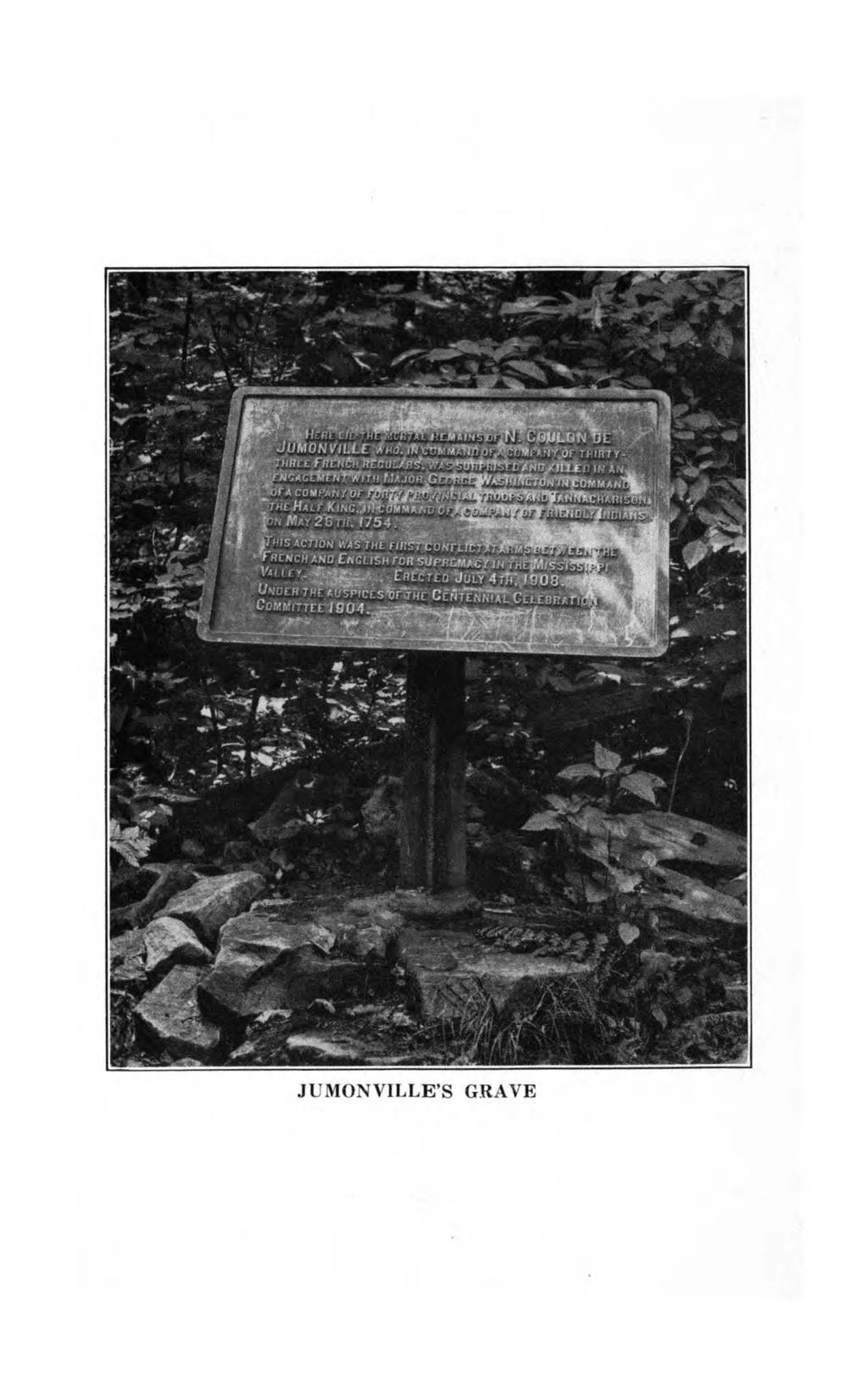
8 JUMONVILLE'S GRAVE
9
10 Laurel Hill 107 Road and the Nemacolin Trail continue as one road to "Gist's Plantation". Nine months after General Washington had bade his officers and soldiers an affectionate farewell, and had resigned his commission to Congress, we find him traveling over this section of the old Braddock Road - of which he wrote in his journal September 12, 1784 "Dined with Thomas Gist at the foot of Laurel, distant from the Meadows 12 miles". At Gist's Plantation, the Eurd Road branched off westward toward the mouth of Redstone Creek and the Monongahela River. The Turkey Foot Road first known as the Pennsylvania Road, an intended route for carrying supplies to Braddock's Army from Bedford through Turkey Foot (now Confluence), intersected with the Braddock Road on top of Laurel Hill at Dunbar's Camp, north of the Great Rock intersection. The western end of the Turkey Foot Road, however, was not cut through for many years after the Braddock defeat. The ancient records, both in Fayette and Westmoreland Counties, refer to this section of the mountains as Laurel Hill. One very early petition presented to the Westmoreland County Court at Hannastown in April, 1774 reads as follows: "We who at present live on the west side of the Monongahela River are obliged frequently to carry our corn twenty miles to the mill of Henry Beeson [Uniontown], near Laurel Hill,and in all probability at some seasons of the year willever have to do so;and therefore pray for a road from near Redstone Old Fort to Henry Beeson's Mill,and thence to intersect Braddock's Road near the forks of Dunlap's Road and said road on top of Laurel Hill." It was the 1774 road that gathered the flyw of travel from the top of Laurel Hill, and held it until the opening of the National Pike, which crossed the mountains at a lower elevation one mile farther south. Like the Nemacolin and the Braddock roads, the Dunlap and the 1774 roads crossed the mountain together as one to a point on the west side of the Hill where they separated. It is quite interesting to trace this old trail from Washington Springs to the west side of the Ridge, after it has been left to slumber in the wilderness for more than a century. The old travel worn channel and the wheel smooth ledges lead the explorer over the wooded top

11 108 Laurel Hill of the mountain, past hacked and scarred old oaks, where he emerges from the timber on the brink of a descent. Here unfolds a scene, and a point readily identified as the same from which the sturdy settler viewed the promised land. This first look from the "top of Laurel Hill"so often described was a picture of enchantment. Before them a vast expanse of giant timber was spread. Billows of closely woven tree tops rose and fell with the hills and valleys, until distance blended them with the mist of the Monongahela. Here trudged the little caravan of the Rev. James Power, bringing his young family to the Redstone Country. They paused at the brink of the descent with amazed wonder as the westward view unfolded before them. The late autumn had touched the foliage, and clothed the landscape in a garb of splendor, as if to decorate the field of labor in honor of the new arrivals. This was in Within two months after this transit and observation, the frontier preacher founded the Laurel HillPresbyterian Church, located about four miles west of the Gist Settlement, where it capped an eminence in the backwood, with blazed trails leading to its crude and humble door. It lent its influence to the development of the Redstone Country one hundred and fiftyyears ago, and stillitcarries on. The Laurel HillChurch, being established so near the mountain base, and so soon after the founder had crossed its summit, can anyone doubt the inspiration that gave itname? Here also crossed "Light Horse Harry Lee", and General Daniel Morgan, the Thunderbolt of the Revolution, as with their hosts they marched over the mountain wall to invade the land of the whiskey insurgents. On this occasion Dr. Robert Wellford, surgeon general to the army, writes:- "Thursday October 30th, (1794). Atnoon this day passed over Laurel Hilland was witness to one of the most extensive views that the imagination can form. On the summit of a mountain of immense height, you see to your rear a country composed of mountainous and rugged aspect, as far as the eye can command. In front, you behold a vale beautiful indeed. At this season a most lovely verdure was retained, and the friendliness of the soil in promoting the growth of grass was evident upon every farm, which every moment opened to view and presented a most desirable prospect of over thirty well cultivated estates and a small

12 Laurel Hill 109 cown called Beeson Town, alias, Union Town". Laurel Hill's importance as a geographic boundary was intensely emphasized during the dispute between Pennsylvania and Virginia over their overlapping territorial claims, which developed into littleless than civil war. The Quaker State was willingto concede the Monongahela River as its western boundary, while the Virginians stoutly denied the Pennsylvania authority to pass the Laurel Hill. Each colony maintained its separate magistrates and civil authorities, who were ready and willing to dispense justice. Laurel Hillwas the dead line, and west of it was the battle ground. One authority committed offenders to prison, while the other broke down the jaildoors and released them. These conditions were the outgrowth of two proclamations of six months before, when Lord Dunmore, Royal Governor of Virginia, while at Fort Pitt, September 17, 1774, issued a lengthy proclamation, of which in part he commanded :- "Ido hereby in his Majesty's name require and command all his Majesty's subjects west of the Laurel Hillto pay due respect to this, my proclamation, strictly prohibiting the execution of any act of authority on behalf of the province of Pennsylvania at their peril and etc." Following this, October 12th, 1774 John Penn, Governor of the province of Pennsylvania, answers in a more lengthy proclamation, and in closing said: "And whereas, although the western lines of the province of Pennsylvania have not been settled by any authority of the Crown, yet it has been sufficiently demonstrated by lines actually run by the most skillfulartist, that not only a great tract of country west of Laurel Hill,but Fort Pitt also, are comprehended within the charter bounds of this province. Ihave thought it fit, with the advice of council to issue this my proclamation, hereby requiring all persons west of Laurel Hill,to retain their settlements as aforesaid made under this province, and to pay due obedience to the laws of this government without paying the least regard to said recent proclamation (Dunmore's) until his Majesty's pleasure shall be known in the premises". Governor Penn here calls attention to the western end of the Mason and Dixon Line, the most celebrated astronomical line known to American History, run in The western terminus of that celebrated line at the time of Penn's proclamation was marked with a post on the

13 110 Laurel Hill east side of the Warriors' branch of the old Catawba war path, near Mt. Morris in now Greene County. The survey was here halted by a committee of Iroquois chiefs, who had been instructed by their council to forbid the line crossing their trail. The details in these old yellow survey documents also link with them important recognition of the Laurel Hill Mountain name as an established location. A letter written from the west end of the Mason and Dixon line while this work was underway gives a memorandum of geographic points as follows: "The 230th mile post west of Delaware River October 22, 1767 "Entrance of Lawrel Hill 210 miles - 13 chains "Left Lawrel Hill217 miles - 13 chains "Crossed Cheat River 219i/2 miles" "East bank of Monongahela 222 miles - 24 chains IV2 mile of ye forks and about 25 miles south of Redstone". The suspension of the Pennsylvania boundary survey covered a period of seventeen years, whereupon immediately after the close of the Revolutonary War the map fixers were again put to work to continue this very scientific task, which was then entrusted to David Rittenhouse, Dr. John Ewing, John Lukens and Capt. Thomas Hutchins, commissioners on the part of Pennsylvania. At least a part of this commission invaded Fayette County in June 1784 and stopped at the "Widow Crawford's", as we learn from a "Memorandum book of John Ewing". The Widow Crawford lived at what is now Connellsville, West Side. She was the widow of the late Colonel William Crawford, who two years before had met that tragic death on the plains of Sandusky. The distinguished guests were met at the Crawford home by General Ephraim Douglass, Alexander McClean, and Jacob Beeson of Beeson Town, who accompanied them to the new County seat. From Commissioner Ewing's journal we find he specially acknowledges and names Laurel Hill when- passing along its western base. On June 28 he writes "After dinner, proceeded to Beeson's Tavern 12 miles farther that evening where we lodged at Mr. Hasten's Tavern. In the afternoon we passed thro richer land than in the morning,
 of a thousand acres, which was the best and largest plot of land we had seen on this side of ye mountains.")
14 Laurel Hill 111 where improvements were large and ye crops were luxuriant. About half way between Mrs. Crawford's and Beeson Town we passed thro Guists Tract (Gist) of a thousand acres, which was the best and largest plot of land we had seen on this side of ye mountains. The Laurel Hill run nearly parallel to our Road. The general direction of the mountain is S-15W, but our road nearly south. At Beeson's Town we crossed Redstone Creek where ye water is brought through ye town to turn a saw mill. There are near 30 houses in this place which is made the County town of Fiatt". Recent use of the new appellation to Fayette County's western mountain has been unduly forced since about After that date reprinted editions of the Uniontown quadrangle map of the United States Geological Survey of Pennsylvania, have blotted out the Laurel Hill name of two centuries use, and inits stead substituted the name "Chestnut Ridge". Hence the new sign-board on the Summit. We have been unable to find any public notice, or the slightest newspaper comment on this change in Fayette County's map, but did, however, find a record of a Pennsylvania legislative act of 1858, changing the name of Brownsville, Pa. This act brought a storm of protest through the newspapers and indignation meetings with resolve after resolve, until the session of 1860 was pleased to repeal the act. Hence, still Brownsville. The erasure from our map of the last remnant of western Laurel Hill will be regretted by most of our members of the Western Pennsylvania Society and students of our local history, who, when reading the letters and journals of Washington wherein he names the Laurel Hill scores of times, willhereafter read it as meaning "Chestnut Ridge". Indeed one name is as fitting as the other, but one has been written through an accumulation of records for two centuries and the other has not. Therein lies the difference. A Chestnut Ridge treatment with like application, could as easily erase from the map, the beautiful name of Monongahela, and extend the Ohio River to Fairmont, West Virginia. Such a remedy, however, ifadopted, would also require an additional sign-board for the National Highway bridge at Brownsville to give public notice that the Ohio River had moved up.
Why is the Treaty at Logstown in 1748 so important? What did it do?
 Student Worksheet A Shot in the Backwoods of Pennsylvania Sets the World Afire Worksheet 1: Focus Questions for "The Roots of Conflict" Instructions: Your group may answer these questions after the reading
Ewing Settlers of Southwestern Pennsylvania Part 5: Uniontown History
 62 Ewing Family Journal Vol. 15, No. 4 (November 2009) Ewing Settlers of Southwestern Pennsylvania Part 5: Uniontown History J. David Ewing (+1 813.624.3979, jdefloridallc at yahoo com), Virginia Ewing
Zeroing in on Christopher Gist s cabin site
 Zeroing in on Christopher Gist s cabin site By Lannie Dietle Christopher Gist looms large in regional and national history for the important role he played in the years leading up to the French and Indian
THE HORN PAPERS AND UPPER OHIO EARLY WESTWARD MOVEMENT ON THE MONONGAHELA. By W. F. HORN. In Three Volumes VOLUME I.
 THE HORN PAPERS EARLY WESTWARD MOVEMENT ON THE MONONGAHELA AND UPPER OHIO 1765-1795 By W. F. HORN In Three Volumes VOLUME I PUBLISHED FOR A COMMITTEE OF THE GREENE COUNTY HISTORICAL SOCIETY, WAYNESBURG,
Genealogy and NORTH CAROLINA Counties
 1 Genealogy and NORTH CAROLINA Counties An ancestor blessed with longevity could have been born in Rowan County in 1753. married in Burke County in 1778, fathered children in the counties of Burke and
Washington Monument Written by Julia Hargrove
 Washington Monument Written by Julia Hargrove Illustrated by Gary Mohrman Teaching & Learning Company 1204 Buchanan St., P.O. Box 10 Carthage, IL 62321-0010 Table of Contents George Washington as a Child
The Historic Pittsburgh
 3 The Historic Pittsburgh Point William H. Stevenson "The Point" is the triangular shaped piece of land between the Allegheny and Monongahela Rivers where they unite their waters to form the Ohio, which
Daniel Boone Led Many Pioneers Through The
 Daniel Boone Led Many Pioneers Through The What topographical features allowed Daniel Boone build a trail through the Daniel Boone led many pioneers on the Wilderness Road/Wilderness Trail. Daniel Boone
Dr. Thomas Graeme to Thomas Penn, LETTER OF DR. THOMAS GRAEME TO THOMAS PENN, 1750.
 Dr. Thomas Graeme to Thomas Penn, 1750. 445 LETTER OF DR. THOMAS GRAEME TO THOMAS PENN, 1750. [The following letter is one of a number in the "Penn Manuscripts," Historical Society of Pennsylvania, written
The Colony of Virginia as Far as the Mississippi
 The Colony of Virginia as Far as the Mississippi I. Background Information Among George Washington s many skills was an aptitude for mapping the land. Even his earliest surveys, done at age 16, show admirable
Thomas Eames Family. King Philip s War. Thomas Eames Family in King Philip s War Josiah Temple The Thomas Eames Family.
 Thomas Eames Family in King Philip s War Josiah Temple The Thomas Eames Family was trying again to make a go of it. Thomas and his wife Mary had each been widowed and had children that they brought to
November 28, Dr. and Mrs. James C. Campbell 346 Bower Hill Road Pittsburgh 28, Pennsylvania. Dear Dr. and Mrs. Campbell:
 Dr. and Mrs. James C. Campbell 346 Bower Hill Road Pittsburgh 28, Pennsylvania November 28, 1964 Dear Dr. and Mrs. Campbell: It is with much regret that I have delayed answering your very pleasant and
The following is a first hand account of the battle at Lexington and Concord. Read the passage, then answer the questions based on the source.
 BATTLE: LEXINGTON and CONCORD The following is a first hand account of the battle at Lexington and Concord. Read the passage, then answer the questions based on the source. SOLDIER EMERSON DESCRIBES THE
General Arthur St. Clair Soldier, Surveyor, Territorial Governor, and Freemason
 General Arthur St. Clair Soldier, Surveyor, Territorial Governor, and Freemason Arthur St. Clair was born in the town of Thurso, in Caithness, Scotland, on March 23, 1736. After finishing his formal education
An Overview of U.S. Westward Expansion
 An Overview of U.S. Westward Expansion By History.com on 04.28.17 Word Count 1,231 Level MAX The first Fort Laramie as it looked before 1840. A painting from memory by Alfred Jacob Miller in 1858-60. Fort
John Miller ( )
") John Miller (1724-1803) Thomas E (1761-1830) Jacob (1782-abt 1845) Francis Marion (1826-1894) Jacob Franklin(1866-1949) Horace Francis (1905-1974) James Richard (1931-) James Aaron (1954-) John Miller
John Miller (1724-1803) Thomas E (1761-1830) Jacob (1782-abt 1845) Francis Marion (1826-1894) Jacob Franklin(1866-1949) Horace Francis (1905-1974) James Richard (1931-) James Aaron (1954-) John Miller
Historic Waynesborough collection
 01 Finding aid prepared by Celia Caust-Ellenbogen and Sarah Leu through the Historical Society of Pennsylvania's Hidden Collections Initiative for Pennsylvania Small Archival Repositories. Last updated
Document Based Question. Evaluate the changes in America ideology and policy towards American Indians between the time period of
 Document Based Question Evaluate the changes in America ideology and policy towards American Indians between the time period of 1763-1835. Document 1 The Royal Proclamation of 1763 King George And whereas
12 Reproducible Comic Book-Style Stories That Introduce
 12 Reproducible Comic Book-Style Stories That Introduce Kids to the Westward Movement and Motivate All Readers by Sarah Glasscock New York Toronto London Auckland Sydney Mexico City New Delhi Hong Kong
William Peters. pg 1/16
 pg 1/16 William Peters No Picture Available Born: 1788 South Carolina Married: Mar 1810 to Rachael Bamberg Died: 1860 Lowndes Co., GA Parents: John Christopher Peters & Mary Unknown Pg 2/16 Article from
ELIZABETH ZIRKLE BIOGRAPHY. Written by Richard E. Harris, OCTOBER, 2008.
 ELIZABETH ZIRKLE BIOGRAPHY. Written by Richard E. Harris, OCTOBER, 2008. Elizabeth Rife Zirkle was born in Timberville, VA April 22, 1836. Her future husband, John Philip Zirkle, lived on a farm three-fourths
Boone County. and the Revolutionary War. By: Robin Edwards Local History Associate
 Boone County and the Revolutionary War By: Robin Edwards Local History Associate Typically the first places that come to mind when asked about the Revolutionary War are Lexington and Concord. After all,
PITTSBURGH, PA., DECEMBER 29th, 1924
 68 Washington Crossing, Address of Dr. George P. Donehoo ADDRESS OF DR. GEORGE P. DONEHOO ATTHE DEDI- CATION OF THE WASHINGTON CROSSING BRIDGE, PITTSBURGH, PA., DECEMBER 29th, 1924 Let me paint you a picture
Logstown. Logs town. (Address by Hon. Henry W. Temple)
") 241L Logstown. Logs town. (Address by Hon. Henry W. Temple) The tablet which is dedicated today marks a spot which has many interesting associations both with the beginning and the ending of the frontier
241L Logstown. Logs town. (Address by Hon. Henry W. Temple) The tablet which is dedicated today marks a spot which has many interesting associations both with the beginning and the ending of the frontier
A GAVEL AT GETTYSBURG: FREEMASONS HONORS THE BATTLE S 150 TH ANNIVERSARY
 When we talk about Masonic History, it is clear that the Lodges of the Grand Lodge of Virginia clearly have plenty of it. Let s face it, many of her Lodges (and the Grand Lodge of Virginia itself) were
T HE success of His Majesty's arms at the forks of the Ohio,
 THOMAS HUTCHINS IN WESTERN PENNSYLVANIA* BY ANNA M. QUATTROCCHI T HE success of His Majesty's arms at the forks of the Ohio, Lunder the command of Brigadier General John Forbes, was the occasion for great
JOB COOPER. c
 JOB COOPER c.1732 1804 The word wanderlust must have been coined to describe Job Cooper, the father of Nathan Cooper. Trying to track down Job brings to mind an old family expression "slipperier than a
Johnny Appleseed in Pittsburgh*
 Johnny Appleseed in Pittsburgh* E. John Long Not far from the city of McKeesport, in the district known as Five Fields, a gnarled apple tree stump stands at the forks of two unimportant country roads.
Transcontinental Railroad
 Name 1 Transcontinental Railroad Long Term Questions How have our leaders impacted the growth of the United States? (4.2.2) How did explorers and pioneers impact the growth of the United States? (4.2.1)
He took part in the expedition against Louisburg, in 1745, as Lieutenant Colonel of a Colonial regiment, and was in the same year made a Captain in
 Pound! In all ye Employments of Agriculture, there is scarce any Thing, which, under proper Management, yields more Advantage, or, perhaps, Amusement, than the Culture of Hops. See a fine Poem, Called
Life on the Roan Oak. Before 1802
 1 Life on the Roan Oak Before 1802 Chapter 1 Previous page: Map of early Roanoke Valley settlements from Kegley s Virginia Frontier. Trigger from a 17 th century British firearm called a snaphaunce, found
Bouquet was born in Switzerland.
 BRITISH Henry Bouquet (Boo-KAY) Bushy Run Creek. This was very smart. The soldiers were tired and they were thirsty. Bouquet and his men used the bags of flour to make a makeshift fort to protect the wounded.
HISTORICAL SOCIETY OF WESTERN PENNSYLVANIA
 Historical Society Joins in Foster Celebration 197 HISTORICAL SOCIETY OF WESTERN PENNSYLVANIA JOINS INFOSTER CELEBRATION. More and more the people of America are coming to honor the memory of individuals
Elizabeth Petersons. Pennsylvania. Uniontown Farmington. Maryland
 Route of Meriwether Lewis from Harpers Ferry, Va. to Pittsburgh, Pa. July 8 July 15, 1803 by David T. Gilbert National Park Service Harpers Ferry, West Virginia May 5, 2003 (Revised September 28, 2015)
HISTORICAL SOCIETY NOTES
 HISTORICAL SOCIETY NOTES THE HISTORICAL TOUR IN MARIETTA The roads were good, the scenery magnificent, and the weather perfect for the tenth annual tour of the Historical Society of Western Pennsylvania
DBQ: Who Caused the American Revolution?
 DBQ: Who Caused the American Revolution? wiki.dickinson.eduwiki.dickinson.edu Who caused the American Revolution? Document 1 That this kingdom has the sovereign, the supreme legislative power over America,
Chapter 11, Section 1 Trails to the West. Pages
 Chapter 11, Section 1 Trails to the West Pages 345-349 Many Americans during the Jacksonian Era were restless, curious, and eager to be on the move. The American West drew a variety of settlers. Some looked
History 32S IB Local History Tour Assignment
 History 32S IB Local History Tour Assignment Before the Trip 1. Review the ArcGIS map of our tour to get a preview of where we are going. The green flags indicate places where we will stop or drive by.
Name: Class Period: Date:
 Name: Class Period: Date: Unit #2 Review E George Washington H Jay s Treaty D Pinckney s Treaty G Treaty of Greenville K Whiskey Rebellion B Marbury v. Madison A. The greatest U.S. victory in the War of
6 RITCHIEs & Caldwells
 6 RITCHIEs & Caldwells the RITCHIE family There appear to be several spellings of the surname Ritchie. In her book, The Richey Clan, Mary Durdin Bird uses the spelling Richey, but other documents and court
Map Exercise Routes West and Territory
 Routes to the West Unit Objective: examine the cause and effects of Independence Movements west & south of the United States; investigate and critique U.S. expansionism under the administrations of Van
THE WELLINGTONS OF TRAPELO ROAD by Elizabeth Castner 1
 THE WELLINGTONS OF TRAPELO ROAD by Elizabeth Castner 1 Roger Wellington was in Watertown as early as 1636. He lived first in the eastern part of the town, his homestall being mostly in Mt. Auburn but was
Mini-Unit Integrating ELA and Social Studies With Maps and Primary Source Documents
 Mini-Unit Integrating ELA and Social Studies With Maps and Primary Source Documents This picture, The Trail of Tears, was painted by Robert Lindneux in 1942. What do you see? Be specific. Trail of Tears
THREE MYTH-UNDERSTANDINGS REVISITED
 The Great Awakening was... the first truly national event in American history. Thirteen once-isolated colonies, expanding... north and south as well as westward, were merging. Historian John Garraty THREE
Captain Samuel Brady s Daring Rescue of the Stoops Family Near Lowellville, Ohio
 Captain Samuel Brady s Daring Rescue of the Stoops Family Near Lowellville, Ohio Researched By Roslyn Torella January 2014 Introduction One of the earliest tales that I could find documented that occurred
Bell Ringer: The Declaration of Independence states people have the right to Life, Liberty, and the Pursuit of Happiness. What does this mean to you?
 Bell Ringer: The Declaration of Independence states people have the right to Life, Liberty, and the Pursuit of Happiness. What does this mean to you? Declaring Independence Road to Revolution One American
REVOLUTIONARY SOLDIERS AT DONEGAL
 REVOLUTIONARY SOLDIERS AT DONEGAL The following article was found among the effects of the late Samuel Evans, Esq., of Columbia. It deals with Revolutionary soldiers who were members of the Donegal Presbyterian
CHRISTOPHER GIST AND HIS SONS 1
 CHRISTOPHER GIST AND HIS SONS 1 As early as 1727 traders on their way west passed through the region that is now western Pennsylvania. These traders are usually classified as French and English;the latter
George Washington. How He Became the Man He is Known as Today BAB
 George Washington How He Became the Man He is Known as Today BAB George Washington The Beginning George Washington, the first President of the United States, was known as, First in war, first in peace
Ohio & Michigan Boundary Posts
 Ohio & Michigan Boundary Posts History, Recovery & Preservation As originally surveyed by Samuel Stinson Gannett and Crew between July and October 1915 Joseph D. Fenicle, PS Ohio & Michigan Professional
A. True or False Where the statement is true, mark T. Where it is false, mark F, and correct it in the space immediately below.
 AP U.S. History Mr. Mercado Name Chapter 3 Settling the Northern Colonies, 1619-1700 A. True or False Where the statement is true, mark T. Where it is false, mark F, and correct it in the space immediately
Capt. Jacob Prickett, Sr.
 Capt. Jacob Prickett, Sr. Patricia Prickett Hickin, comp. ============================================================================ Capt. Jacob Prickett, Sr. ============================================================================
Stargazers, Ax-men and Milkmaids The Men who Surveyed Mason and Dixon s Line
 Stargazers, Ax-men and Milkmaids The Men who Surveyed Mason and Dixon s Line Todd M. BABCOCK, USA Key words: Mason, Charles; Dixon, Jeremiah; Surveyors; Penn; Calvert; Pre-revolutionary history. ABSTRACT
Historical Society of Whitpain local history collection
 01 Finding aid prepared by Celia Caust-Ellenbogen and Michael Gubicza through the Historical Society of Pennsylvania's Hidden Collections Initiative for Pennsylvania Small Archival Repositories. Last updated
Table of Contents. Our Pennsylvania Story 5
 Table of Contents United States Political Map...........................................2 Pennsylvania Political Map...........................................3 Pennsylvania Physical Map...........................................4
It is not the intention of the author of this brief monograph
 178 In Pennsylvania In Pennsylvania It is not the intention of the author of this brief monograph to give a history of the wanderings of the Shawnee previous to their appearance within the Colony of Pennsylvania.
664 INDIANA HISTORICAL COLLECTIONS
 664 INDIANA HISTORICAL COLLECTIONS PIKE COUNTY I DECEMBER 21, 1816: Formation by statute, effective February 1, 1817. The formation affected Gibson and Perry counties. BOUNDARIES: "Beginning at a point
A MASON IN MOCCASINS
 A MASON IN MOCCASINS Presented by Worshipful Bro. Edwin L. Vardiman William O. Ware Lodge of Research April 12, 1984 When we think of the time of the American Revolution, as Masons we often remember with
Concord Township Historical Society. local history manuscripts collection
 Concord Township Historical Society local history manuscripts collection 04 Finding aid prepared by Celia Caust-Ellenbogen and Faith Charlton through the Historical Society of Pennsylvania's Hidden Collections
Print settings for printable version with background image, print the following pages:
 Print settings for printable version with background image, print the following pages: Print pages: 2 ~ 8 Print settings for printable version without background image, print the following pages: Print
Tennessee State Library and Archives
 Box 1 -- Folder 1 Tennessee State Library and Archives LETTERS OF THE TENNESSEE GOVERNORS JOHN SEVIER 1796-1801 ( Part 1 ) NAME YEAR PLACE INCOMING OUTGOING SUBJECT Smith, Daniel (Gen.) 1791 Philadelphia,
Open Up the Textbook (OUT)
") Open Up the Textbook (OUT) Enlarge Complicate Contest Vivify Title: Wagon Trains and the Forty-Mile Desert Authors: Bree Evans, Geri Moore, Erica Pienkoski, Johnna Ramos, Michael Raybourn, Lisa Smith,
Open Up the Textbook (OUT) Enlarge Complicate Contest Vivify Title: Wagon Trains and the Forty-Mile Desert Authors: Bree Evans, Geri Moore, Erica Pienkoski, Johnna Ramos, Michael Raybourn, Lisa Smith,
Beers Atlas of Worcester, 1870, p.7 (partial) Supplement 2-A. (from photograph by author)
 Supplement 2-A. (from photograph by author)") Beers Atlas of Worcester, 1870, p.7 (partial) Supplement 2-A (from photograph by author) G. M. Hopkins, Atlas of Worcester, 1886, Plate 23 (partial) Supplement 2-B courtesy of Worcester Public Library
Beers Atlas of Worcester, 1870, p.7 (partial) Supplement 2-A (from photograph by author) G. M. Hopkins, Atlas of Worcester, 1886, Plate 23 (partial) Supplement 2-B courtesy of Worcester Public Library
REPURPOSED AP US HISTORY DBQ
 REPURPOSED AP US HISTORY DBQ AP United States History Practice Exam NOTE: This is an old format DBQ from 2004 reformatted in an effort to conform to the new DBQ format. The prompt has been altered slightly
Living History Readers: Pilgrims and Colonists
 Living History Readers: Pilgrims and Colonists by Smith Burnham revised by Sandi Queen 2015 Queen Homeschool Supplies, Inc. 168 Plantz Ridge Road New Freeport, PA 15352 www.queenhomeschool.com 1 2 Chapter
Early Civilizations in India and China
 Copyright 2003 by Pearson Education, Inc., publishing as Prentice Hall, Upper Saddle River, NJ. All rights reserved. Chapter 3, Section World History: Connection to Today Chapter 3 Early Civilizations
SKETCH OF JOSEPH SIMON,
 SKETCH OF JOSEPH SIMON, About the year 1742 several Hebrew families settled in Lancaster town and engaged in shop-keeping, in which calling they prospered. I will refer to one of them, who became one of
Lewis and Clark for Kids
 Lewis and Clark for Kids Their Journey of Discovery with 21 Activities JANIS HERBERT Contents Time Line viii Preface To the Westward xi Time Line of the Lewis and Clark Expedition Map of the Expedition
THE MYTH OF FORT POMFRET CASTLE
 THE MYTH OF FORT POMFRET CASTLE By MARVIN W. SCHLEGEL Assistant Historian, Pennsylvania Historical Commission, Harrisburg A CCORDING to several statements by Governor Morris of A Pennsylvania, Fort Pomfret
The Knowledge Bank at The Ohio State University. Ohio Mining Journal.
 The Knowledge Bank at The Ohio State University Ohio Mining Journal Title: Issue Date: Proceedings of the Ohio Institute of Mining Engineers: Summer Meeting 15-Aug-1885 Citation: Ohio Mining Journal, vol.
JOHANN ADAM BIBLE SENIOR AND HIS SONS, JOHANN CHRISTIAN BIBLE AND ADAM BIBLE, JUNIOR
 JOHANN ADAM BIBLE SENIOR AND HIS SONS, JOHANN CHRISTIAN BIBLE AND ADAM BIBLE, JUNIOR In June of 1775, forty-seven year old Johann Adam Biebel (Bible), Sr., who was born in Goersdorf, Alsace in 1728, was
THE LATE GREAT PUGET SOUND MERIDIAN. Washington State s Own Principal Meridian. by Denny DeMeyer
 THE LATE GREAT PUGET SOUND MERIDIAN. Washington State s Own Principal Meridian by Denny DeMeyer Pausing briefly in a clearing in the forest while ascending a ridge just south of Bellingham, the surveyors
John Egan may be said to have started the real
 CHAPTER II Old Fort Dallas-The Biscayne Bay Country-Before the Day of Sub-Divisions-The Man Who Started the Real Estate Business in Miami- Mrs. Julia D. Tuttle, Woman of Vision-A Long Sleep and a Slow
Chapter 3. Alabama: Territory & State
 Chapter 3 Alabama: Territory & State Lesson 1 (page 71) 13 Colonies began to object the way the British king and Parliament made rules for them. France & Spain helped the colonies win the war. BrainPOP
Battle of Point Pleasant FIRST BATTLE OF THE AMERICAN REVOLUTION OCTOBER 10, 1774
 Battle of Point Pleasant FIRST BATTLE OF THE AMERICAN REVOLUTION OCTOBER 10, 1774 By MRS. LIVIA SIMPSON-POFFENBARGER, LL. D. (Mrs. George Poffenbarger) Web link: http://www.pointpleasantwv.org/parks&campgrounds/stateparks/tuendiwei/batt
Wallace Township local history collection
 04 Finding aid prepared by Celia Caust-Ellenbogen and Sarah Leu through the Historical Society of Pennsylvania's Hidden Collections Initiative for Pennsylvania Small Archival Repositories. Last updated
American Revolut ion Test
 American Revolut ion Test 1. * Was fought at Charlestown, near Boston * Took place on Jun e 17, 1775 * Was a victory for the British Which Revolutionary war battle is described above? a. The Battle of
HIST-VS Pemberton_Malecky_VS6Test_Test Exam not valid for Paper Pencil Test Sessions
 HIST-VS Pemberton_Malecky_VS6Test_Test Exam not valid for Paper Pencil Test Sessions [Exam ID:0LY71F 1 In what order were these documents written? A 2,1,3 B 3,2,1 C 1,2,3 D 3,1,2 2 Whose name completes
Activity Introduction Hey there, I d like to welcome you to today s lesson Defining and Settling Louisiana! It s gonna expand your mind for sure!
 Defining and Settling Louisiana H1092 Activity Introduction Hey there, I d like to welcome you to today s lesson Defining and Settling Louisiana! It s gonna expand your mind for sure! Video 1 Introduction
SQUATTERS AND TITLES TO LAND IN EARLY
 Squatters in Early Western Pennsylvania 165 SQUATTERS AND TITLES TO LAND IN EARLY WESTERN PENNSYLVANIA (a) or AnIntroduction to Early Western Pennsylvania Land Titles The subject of Squatters and Titles
Between the early 1830s and the mid 1850s, a new political party called the Whigs ran in opposition against the Democrat party of Andrew Jackson.
 Between the early 1830s and the mid 1850s, a new political party called the Whigs ran in opposition against the Democrat party of Andrew Jackson. They believed in congressional supremacy instead of presidential
Mexican-American War Act-It-Out
 Florida Act-It-Out Follow the narration below to create an act-it-out about Florida. When the narrator says Action! the actors will move, act, and speak as described. When the narrator says Audience! the
Who were the Mormons and why did they decide to Head West?
 Who were the Mormons and why did they decide to Head West? Learning Objectives: To understand who the Mormons were and why they were unpopular in the East. To assess how successful their move West was
Chapter 4 MOUNTAIN MEN
 Chapter 4 MOUNTAIN MEN Jedediah Smith Ethnicity: American Company: Ashley-Henry Company Location: All over Utah Accomplishments: Leader among trappers First to travel the length and width of Utah Proved
286 Notes and Queries
 286 Notes and Queries NOTES AND QUERIES ttooft noticed THE BOY GEOBGE WASHINGTON, AGED 16: His OWN ACCOUNT OF AN IROQUOIS INDIAN DANCE, 1748. By Albert Cook Myers, Chairman of The Historical Committee
The Great Encounter: American Indians Meet Explorers & Mountain Men
 Slide 1 CHAPTER 4 The Great Encounter: American Indians Meet Explorers & Mountain Men Slide 2 The Mood Just as different groups of Native American Indian people had displaced other groups who lived in
The Sullivan Expedition of 1779 Battle of Chemung August 13, 1779
 The Sullivan Expedition of 1779 Battle of Chemung August 13, 1779 INTRODUCTION: In our study of the Sullivan Expedition in 1779, and Capt. Anthony Selin s Independent Company s role during this campaign,
The General William Henry Harrison Trail through Portions of Vermillion County and Warren County, Indiana Written 11 October 2015 by Curtis L.
 The General William Henry Harrison Trail through Portions of Vermillion County and Warren County, Indiana Written 11 October 2015 by Curtis L. Older Five Probable Points Along the Harrison Trail, including
MEMORIAL TO JOHN WESLEY POWELL
 A MEMORIAL TO JOHN WESLEY POWELL BY FREDERICK S. DELLENBAUGH FTER four years in the Civil War, Major John Wesley Powell, minus his right forearm, which remained on the field of Shiloh, turned again to
Assessment: Life in the West
 Name Date Mastering the Content Circle the letter next to the best answer.. Assessment: Life in the West 1. Which of these led to the Lewis and Clark expedition in 1804? A. Monroe Doctrine B. Gadsden Purchase
Pea Ridge: Civil War Campaign in the West
 The Annals of Iowa Volume 52 Number 4 (Fall 1993) pps. 468-470 Pea Ridge: Civil War Campaign in the West Russell Johnson ISSN 0003-4827 Copyright 1993 State Historical Society of Iowa. This article is
Chapter 3: Many Flags over Iowa
 Chapter 3: Many Flags over Iowa CONTENT OBJECTIVES IOWA PAST TO PRSENT TEACHERS GUIDE Revised 3 rd Edition Following the completion of the readings and activities for this chapter, students will have acquired
Southern Campaign American Revolution Pension Statements & Rosters
 Southern Campaign American Revolution Pension Statements & Rosters Pension application of William Holland W4698 Margaret fn62nc Transcribed by Will Graves 5/10/11 [Methodology: Spelling, punctuation and/or
Introduction and Transcription to the Andrew Woods Deerskin Booklet
 Introduction and Transcription to the Andrew Woods Deerskin Booklet Accreditation This deerskin covered booklet belonged to an Andrew Woods of Virginia, between 1759-1789, whose father had died in 1758.
TUESDAY, AUGUST 22 WARM-UP UNPACK STANDARD 1. WRITE THIS STANDARD IN YOUR NOTEBOOK
 TUESDAY, AUGUST 22 WARM-UP UNPACK STANDARD 1. WRITE THIS STANDARD IN YOUR NOTEBOOK in the 3 rd section. 8.2 Trace and explain the founding of Jamestown, including: Virginia Company, James River, John Smith,
A life sketch of Mary Hutton McMurray
 A life sketch of Mary Hutton McMurray 1801 1896 There were many women in the early days of the Mormon Church that after the death of their husbands, were left without means of support for themselves and
United States History. Robert Taggart
 United States History Robert Taggart Table of Contents To the Student.............................................. v Unit 1: Birth of a Nation Lesson 1: From Colonization to Independence...................
Luther Family Millstone Memorial
 This building was torn down in the late 1970 s Luther Family Millstone Memorial Roger Luther who lived nearby at the time, remembers when that one room school building was demolished in 1978. The memorial
Georgia Studies: Final Exam 2015!!!!!
 Georgia Studies: Final Exam 2015!!!!! 1. Who is known as the first European to encounter the Mississippians in Georgia? a. Hernando de Soto b. James Oglethorpe c. Alexander Stephens d. Christopher Columbus