THE MOUNT INDEPENDENCE-HUBBARDTON
|
|
|
- Marlene Ryan
- 5 years ago
- Views:
Transcription
1 THE MOUNT INDEPENDENCE-HUBBARDTON 1776 MILITARY ROAD I. RELATED EARLY ROADS. MOUNT INDEPENDENCE. HIS is the first of a three part article on a Revolutionary Road, Tsorely neglected by historians and by the State of Vermont, almost obliterated, but important and interesting to the public at large as well as to the hundreds who have seen or heard of some part of it. It might be considered as a short cut branch of the Crown Point Road, though that was built seventeen years earlier. What one British officer called "The Great Road," was built in I776, through Orwell, Benson, Hubbardton, Castleton, Ira and West Rutland, to Rutland Fails, when, afrer the taking of Fort Ticonderoga, May I o, I77 5, the Continental Congress determined to fortify Mount Independence, opposite Ticonderoga. It was used by the soldiers going back and forth from Ticonderoga and Mount Independence to Castleton, Rutland, Bennington, and "Number Four Fort" at Charlestown, New Hampshire and other parts of New England. From Mount Independence as far as the Battlefield and thence for two miles south on the earlier East Hubbardton road it was also the main road, from the Mount, in a wide half circle through Castleton, to Skenesborough (Whitehall); no shorter road from Orwell then existed until the Hydeville branch road was built, probably in q8r. No doubt much of the ammunition, equipment and stores on Mount Independence were hauled by wagon and packload over the earlier Crown Point Road up to Center Rutland and thence over this rough frontier road. There are grounds for holding that Mount Independence is the most important, interesting and neglected historic site in Vermont. Independence was the main encampment for the Northern Army. According to Orders of July 22, 1776, three of the four brigades, under General Arnold, Colonel Reed and Colonel Stark, more than three thousand men at times, were stationed there and only one brigade at Fort Ticonderoga.1 Most of the new construction was on the Vermont side rather than at "Ti". Most of the New England [ 88 ]
2 soldiers assigned to the Mount and to Fort Ticonderoga must have marched over our road, and some 2500 men retreated over it to Hubbardton, Rutland and Skenesborough, in July I 777, pursued, as far as Castleton, by more than zooo British and their allies; then in September I777 on the second and final attempt to retake the Fort; thereafter by soldiers and settlers to the lake towns after it was given up by the British in I 780. As we shall see below, a branch road forking off in northeast Benson, a mile east of Howard Hill, was built in I 7 8r to the mills and new stockade at Hydeville, then called Castleton Falls. Thousands of men from the northern colonies, and British, Hessians, French and Indians, travelled this road, through woods and swamps, between Mount Independence, Castleton and Center Rutland, three of the main frontier outposts of American civilization. For some time such celebrities as Benedict Arnold, Thaddeus Kosciusko, the Polish engineer who volunteered for the American cause, Generals Schuyler and Gates, and Colonels Anthony Wayne and John Trumbull were busy at the Mount. Over this road a famous _\merican General Arthur St. Clair, as well as Seth Warner, retreated with two noted British and German Generals in pursuit, Simon Fraser and Baron Riedesel. Are we mistaken in thinking it should be of interest to our own generation? And that all those efforts, the memories of these men, many of whom died of hardships and disease at the Mount, deserve some recognition at this late date? Several hundred persons are directly interested in this road, having lived on or near it at some time; some of them now living in distant states have given vital information. Scores have generously taken the time, in the true spirit of Sherlock Holmes, to search carefully through woods and fields for traces of the exact roadway; such traces still keep turning up. Old corduroy, stone abutments, fills and dugways are still visible at many points, but in general the road, after these I So years of disuse, is scarcely traceable, just as the better known Crown Point Road is almost completely obliterated for most of its course. Strangely, we have discovered no other attempt to trace either the history or the route of this road, with the exception of a two page all too general letter from Captain Charles Abell, cited below, which describes part of the route, and led us to think at first that it went only to Hubbardton. Since the summer of I945, by spending two or three hours a week, by countless trips over portions of the route, by conversations with anyone who had a clue, by continual correspondence and hundreds of
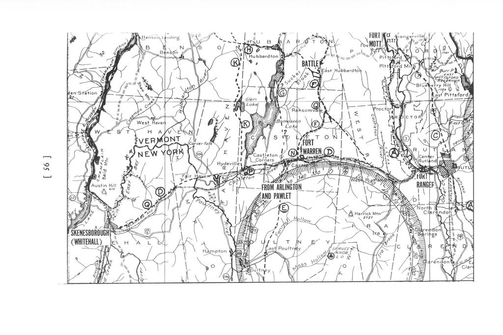
3 telephone inquiries often resultful, by search through books, documents and maps, we have pieced together the story here told. We are grateful to the more than 3 so persons who have helped us. This was furthered by issuing three successive mimeographed summaries: so copies of r 7 pages in March r 94 7; 7 5 copies of 45 pages November rs, 1949; 1oo copies of a third draft, 8r pages, July 4, 1956, to interested persons, asking further help. A tentative account was published in four articles in Rutland Herald2 in August r 9 51, the 175th anniversary of the road, with several air photos taken by the Herald's Andrew Merusi, and a map by Robert Wheeler from the Mount to Hubbardton line. Several assumptions in that series have since been corrected. At our request the Castleton Historical Society appointed a committee in 1950, and in 1952 the Vermont Historic Sites Commission appointed a committee in each town, resulting chiefly in valuable ground work by Mr. John Rei! of Castleton. In December 1957 a request to West Rutland Rotary Club to appoint a committee to study the route there, resulted in three detailed articles based on extensive document and field research, by Mrs. Phyllis Humphreys in the Rutland Herald3, with promise of one or two more. In October 1958 the Vermont Historic Sites Commission, after our continued requests, erected fifteen steel posts and metal signs "Hubbardton Military Road, I n6," at the intersections of the old road with present blacktop highways, with one in Belgo Gap. As this investment of $7 5 by the State of Vermont seemed inadequate to mark the route followed by thousands of our Revolutionary soldiers, the selectmen in the seven towns concerned paid for and erected forty additional markers through the woods and fields where the route is easily lost, in the spring of 1959 to coincide with the 35oth Champlain Celebration. We shall attempt to give first the history of the road with a brief account of Mount Independence, and then its detailed course, including the Hydeville Branch. PREVIOUS ROADS The Hubbardton Military Road was not built, as some have thought, for the taking of Fort Ticonderoga. That expedition of the Green Mountain Boys under Ethan Allen from Bennington and Castleton to Ticonderoga, was a fairly sudden one. Paul Revere's famous ride "on the 19th of April in '75" occurred less than a month earlier. Ethan Allen had not heard of it until his own plans were well along. If any preparations, like the building of a new road, had come [ 90 ]
4 to the ears of the British, it would have been fatal to the success of Allen's expedition. He and his men came up from Bennington, through Pawlet and Poultney (now East Poultney), 4 and according to a tablet in front of Castleton Church were joined by Benedict Arnold at the Remington Tavern, a half mile west of Castleton village on present U.S. Route 4 However, it is more likely that Arnold found Allen and his men gone and caught up with them at the Abel Randall Benjamin Hurlbut farm in Shoreham a little south of Hand's Cove. 5 Their route thence is thought by some persons in Castleton to have been northerly along a bridle path west of the north road in Castleton village, coming out west of Pine Pond to the east shore of Bomoseen near Prospect Point, thence approximately along Route 30, via the north end of Bomoseen and the west side of Beebe Pond. This may have been the trail cut earlier by the Aliens to reach their lands in Colchester, and later improved. This seems to conform to a Rutland Herald letter6 describing corduroy and other traces of what was reported as "a military road" that ran "from the village... just north on the Rogers farm... skirts the ledge along the eastern side of the lake and joins the Troy Burlington turnpike [Route 30 ] near the site of Castleton Town Farm [a bit SE of Crystal Beach] thence past Hubbardton Church where at Webster's Stand [in Sudbury] it joins the main route to Crown Point." Evidence of a "Ticonderoga Road" running along Beebe Pond's west shore, is noted below, in describing the road near Austin Pond, where we mention a Hubbardton deed and a letter to us, 7 both citing a "Ticonderoga Road." This road could only have come from along the northeast shore of Bomoseen and connected further north in Sudbury with the Crown Point Road. It seems unlikely it could have been built as a real road before the Mt. Independence Road was built. Burgoyne's maps of his campaign and of the Hubbardton Battle, show no north-south road west of the East Hubbardton road. It seems more likely a branch north from the Hubbardton Military Road at the outlet of Austin Pond. It is surprising to discover on a large wall map of Rutland County, 8 r854, that from Hydeville, on the Whitehall & Castleton Railroad, a branch of the Rutland and Albany Railroad had been surveyed and appears as "projected," leading along the east side of Lake Bomoseen, west of Route 30, passing near the outlet of Austin Pond, crossing the highway that had been the Hubbardton Military Road and skirting the west shore of Beebe Pond close to the present campers' road, then crossing the later turnpike Route 30, probably at the north end [ 91 ]
5 of the hill on this main highway. It continued up through Whiting to the main line of the Rutland Railroad. Evidently this was a good grade for the obscure route of an early road along Beebe Pond, to reach up through Sudbury west of the East Hubbardton road, and strengthens the idea of some son of road or path up from the Remington Tavern. L. E. Chittenden9 quotes Goodhue's History of Shoreham: 10 "It has been supposed by many that the expedition followed the nearest route through Benson, to a point opposite the fort in Orwell. This supposition is incorrect. Leaving Castleton, it moved by the way of Sudbury, where it struck the old Crown Point road, and following that through Whiting, reached the lake shore at Hand's Cove in Shoreham, about two miles north of the fort on the other side. The distance by this route was about twenty-five miles, seven or eight farther than by the other [i.e. by the Mt. Independence Road.] There were two reasons for taking it: it was farther from the lake, and there was less hazard of discovery, and it brought them to the shore in a wooded ravine, where they were perfectly sheltered from observation." But Chittenden and Goodhue were in error in mentioning "the nearer route" through Benson; the latter was not built until seventeen years after the Crown Point Road and a year and a half after Allen's men took Ticonderoga. The mistaken idea that the Castleton Hubbardton-Benson military road was used by Allen's troops seems to have started in Thompson's Green M(JUntain Boys, ll "The route of [Allen's] troops was along the military road, which in the French war of 17 59, had been opened from Charlestown, on Connecticut River, across the Green Mountains to Lake Champlain... This road, leading directly through Castleton, and taking a northerly direction, branched off within a few miles of the lake, one fork... to Ticonderoga, and the other... to Crown Point." The road did have two forks, but Thompson's error lay in thinking that this Crown Point Road went near Castleton village or into Castleton at all. All the studies of the Amherst-Stark-Hawks-Gaffe road, its two Rutland branches and its Ticonderoga branch, quite naturally fail to mention the Castleton-Hubbardton-lndependence road because it was not built until r 77 6, and the Skenesborough Road through Castleton not until As Smith's Rutland C(JUnty says,12 "The first of the two Rutland branches of the Crown Point Road passed through Rutland, from what was called the Little Falls and Center Rutland and was only in use prior to " [This date seems questionable]. "The second branch ran north from what is now Main Street, intersecting the first branch in Pittsford." [ 92 ]
6 "Many towns have claimed to have been on the line, through which it did not go, especially in the western section of the county."13 This latter statement is important because occasional references are found in various printed sources, that Castleton or Hubbardton were on the Crown Point Road, whereas this could not be so. Smith states14 that "The first road in town, [Hubbardton ] was the old "Ti." road, which was too rough and crooked to be of much use to the settlers. The next was more useful, being a north and south road through the east part of town." Unfortunately, the early records of Hubbardton were lost or destroyed so that events there are shrouded in uncertainty. But it is important that he mentions two roads in Hubbardton, the latter sounding like the present East Hubbardton highway past the Battlefield. It is said15 that in I 77 2 Ira Allen had cut a bridle path from Castleton through Vergennes to their "Onion River land project" at Colchester. This may have been along Pine Pond, but it is known that the present main road from Castleton north through East Hubbardton * was built in On October 3, the proprietors of Castleton chose three of their number to lay this out, and another three men including Reuben Hickock, to lay out an improvement of the Skenesborough road. Among diaries and letters of soldiers, such as Epaphrus Bull16 of Stockbridge, we have found no clarifying description of the route used. If they went from Remington's Tavern via the Skenesborough Rutland road east to where Fort Warren was built in I779, thence northward through East Hubbardton (then called Hubbardton) to Sudbury, it would have been two miles longer than the Pine Pond route; most of the men appear to have been on foot, and a trail or bridle-paths rather than a road was all they needed. As for the famous Crown Point Road, a full description of its route is almost certain to be written and published within the next year or two, by someone among the many persons now tracing it. In I956 the writers realized that the woth anniversary of the first building of this road would soon come up, that its route still uncertain in many towns should be traced and marked, and after collecting data that had drifted in to us we fortunately prevailed on Miss Flora B. Weeks of Rutland, later appointed State Historian of D.A.R., to undertake to head up the project of getting persons in each of the eighteen towns on its 87 mile route, to studying the detailed course of this famous road, which was started in I 7 59, finished in I 760, at the end of the French and Indian War. Little used by soldiers until the Revolution it immediately opened up central Vermont for settlement. *Addenda, 9 3. [ 93 ]

7
8
9 At this writing more than two hundred enthusiasts, encouraged by Miss Weeks, have been at work in I957-I958 and several towns are ready for markers. Beside a series of preliminary articles by Miss Weeks17 a descriptive article and map is needed for each town, to draw out further data. This will supplement and modify the excellent substantial thirty-page account and map Mrs. Mary Fletcher Charlton prepared in I 93 I, 18 which stimulated erection of a number of stone markers by chapters of the D.A.R. (so well informed a person as Mrs. Charlton told us in I946 that she had never heard of the Mt. Independence-Hubbardton Road). We therefore omit details of the history and route of the Crown Point Road from Fort No. 419 at Charlestown, New Hampshire, crossing the Connecticut at Wentworth's Ferry, and through Springfield to North Clarendon, where its earlier route may have crossed Otter Creek, with a second route a year or two later running up Main Street in Rutland, the two routes joining again at Pittsford, thence through the southwest part of Brandon, into Sudbury, Whiting, Shoreham, Bridport and perhaps, as many writers assume, reaching the lake at Chimney Point opposite the Crown Point Forts, though this crossing point is uncertain to date; early maps show the road coming out at points on the east shore of Champlain, some distance south of Chimney Point. We leave this for others, as well as an account of the French village at Chimney Point, another interesting site neglected by Vermont historians, of Forts Mott and Vengeance, in Pittsford, and of Rutland Fort (which was at the northeast corner of the intersection of Main and West Streets and not where the D.A.R. marker stands in front of the Armory; the old well of this I 775 fort was filled in some years ago in the rear of the lot where Lindholm's restaurant stands.) The history of the building of Crown Point Road, but not its detailed route, has been thoroughly covered in an article20 and a book21 by William Howard Brown. Between Rutland, Rutland Falls and West Rutland the Crown Point Road is of direct concern, for evidently a short cross road, described in later pages, was built directly to the fort and brid e at Rutland Falls, the eastern terminus of the Hubbardton Road.* We are also concerned with another fork, which might be called the Ticonderoga branch of the Crown Point Road which Ethan Allen's men took when they reached it in Sudbury; its destination was F art Ticonderoga. Both branches are shown on the old Walling and Hagar22 wall map of Vermont, I869, but neither of them on Scott's map of Rutland County, I Walling's map shows it *Addenda, 96.
10 branching off westward in the southwest corner of Whiting, through the northeast corner of Orwell above the present railroad station, and thence just above and close to the south line of Shoreham, to the present Larrabee's Point. Hand's Cove where the Green Mountain Boys embarked in crossing the lake to take the Fort, on May 1 o, 1775, is about one third mile north of Larrabee's Point Ferry. Several traces, noted by local residents, warrant our surmise that the route may have been from the northwest corner of Sudbury and across near the northern boundary of Orwell, until it passed the north side of Hardigan Hill and then swung north across the Shoreham line where later the Addison Branch of the Rutland Railroad23 was built, in 1871, to its former Larrabee's Point station and crossing trestle, at a smaller point somewhat south of Larrabee's Point.* The difference between our 1776 Hubbardton road to "Ti," and the "Ti" branch of the Crown Point Road is effectively shown in the remarkable map drawn in August 1776 by Col. John Trumbull, later famous as "Artist of the American Revolution" which appears in the 1841 edition of his Autobiography,24 but not in Sizer's annotated edition of This beautiful steel engraved map herewith reproduced in part, shows the "Road from Number Four" in words only, but not lines, coming out close to what seems to be the later railroad trestle point. It was two and a half miles south where a short road led down from the south end of Mount Independence to the "Landing from Skenesborough." It was from the easterly bend in this road that the new Hubbardton road builders started, about a month after Trumbull made his map. As it ran southeasterly instead of easterly it cut nearly five miles of travel compared to the Crown Point Road. We have tried, unsuccessfully as yet, to persuade a number of persons to trace the Ticonderoga branch of Crown Point Road. As far back as 1861, Elias Hall, son of a soldier who had "walked the Old French Road in 1759"26 wrote that "the state surveyor is now unable to locate this road on the west side of the mountains." This may explain doubts as to Walling and Hagar's map and uncertainties a century later. Various chapters of the D.A.R. have erected numerous stone markers along the Crown Point Road; some of those on the Ticonderoga branch may not be accurately placed, as they do not seem to line up realistically. However, on Route z za the granite marker at the first intersection south of the former Orwell railroad crossing and more than a mile south of the Shoreham boundary reads "Mili- *Addenda, 97. [ 97 ]
11
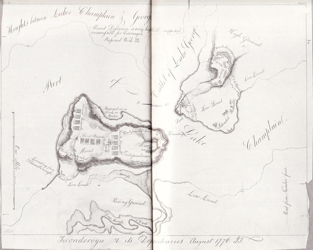
12 tary Koad from Mount Independence to the Amherst Road. Erected by Hand's Cove Chapter. D.A.R." In 1958 Mrs. Mary Bodfish of Orwell told us all the members of the committee for this marker had passed away and that the chapter records contain no material about this road, which we have never seen mentioned in any book, document or map, but which could possibly have been used in the few weeks after Mount Independence was for the first time, in July, occupied by soldiers and before the Hubbardton Road was started in September. Tom Daniels of Orwell has found traces of an old roadway eastward crossing East Creek below the Mount. There is also the tradition of soldiers using the spring a few hundred feet southeast of the D.A.R. marker. We have not followed up this short crossroad, and have wondered as to why it should have existed.* In the winter of , a few months before the Army officers considered and decided on fortifying Mount Independence, the situation at Boston was crucial, and some of the roads just discussed were used to transport guns and material through Vermont to Boston. Washington had tardily been appointed Commander in Chief of the Continental Army on June 15; the Americans were defeated at Bunker Hill on June 17; they were in desperate straits for military equipment and ammunition, with which to continue the siege of Boston in July. General, then Colonel, Henry Knox made an expedition to Fort George at the south end of Lake George, and to Ticonderoga and Crown Point, to gather all available guns and ammunition. More than fifty cannon, howitzers and mortars, and other materials from Crown Point and Ticonderoga were hauled through the winter snows to Boston, leaving the northern garrisons in a bad plight. "The winter of r 77 s-r 776 was a terrible one for the American garrison at Ticonderoga. The sufferings were worse than at Valley Forge. Many men froze to death in their tents."27 A large colored poster, published in 1947 by the Dixon Pencil Company to advertise Ticonderoga pencils, shows Knox's men and oxen hauling the dismantled cannon on sleds over the hills. The caption reads, "Immortal Guns. General Knox and his men taking guns from Fort Ticonderoga to General Washington at Dorchester Heights in OPPOSITE. Portion of Trumbull's map, August 1776, with the three brigades spread out on the Mount before the Star Fort and Horseshoe Battery were built, but with road running from north to south. The star shaped stockade fort and the hospital were built later. *Addenda, 99. [ 99 ]
13 the siege of Boston in the winter Df rn6." This colored illustration is also reproduced in Vermont Lije 28 Autumn 1948, and in Newton's The Vermont Story. 29 When the writers first saw this poster, which shows Fort "Ti." across the lake, we thought it might portray the Hubbardton Military Road. But these guns were hauled more than six months before our road was built. \\e then thought they must have been drawn over the Crown Point Road. But a bronze tablet in the central yard at Fort Ticonderoga shows a map of their route south from "Ti." to Skenesborough, Fort Edward and Albany, where they crossed the Hudson on the ice, thence southerly into western Massachusetts and eastward to Boston. Another bronze tablet to the same effect is mounted on a boulder on the library lawn at Hudson Falls. In crossing the Mohawk River ice at Half Moon they lost one cannon (recently fished up and now set up in the central yard at the Fort). A third tablet stands at Woronoco, near Westfield, Massachusetts. This roundabout way was evidently the quickest and easiest at that time, for it was much more heavily travelled, especially in winter. A stone bridge at Wayland, Massachusetts, twenty miles west of Boston, had to be abandoned in r 956, damaged beyond repair after 233 years. Over it a train of forty sleds drawn by So yokes of oxen brought the guns to Boston.30 No doubt this was the train that went through Westfield. However, data at East Poultney seem to indicate that some of the guns, probably from Crown Point, were sledged "over corduroy roads down from Castleton by the old road [to Pawlet and Bennington] made the turn at Eagle Tavern, [around the northeast corner of the Green] over the old road where I had marked in 1935, 'The First Union Church in America,' then south over a bridge over Poultney River, the remnants of the old masonry still there the last time I looked at the site, and on top of the hills, to avoid sniping by British and Indians, and on in the direction of Boston."31 These guns probably came down over the Crown Point Road to Sudbury, thence by* the East Hubbardton Road to Castleton. See also W. E. Johnson's article "The Eagle Tavern."32 Perhaps they took this roundabout way because the Pawlet, Bennington, Williamstown road was in better shape than some portions of the Crown Point Road. But there is also evidence that some of the cannon went via the latter road. Photographer C. E. Walker23 says that below Twenty-Mile Encampment and Whitesville, "I have seen the rotted logs which were piled against the embankment at Downer's to ease the cannon for Dorchester Heights down onto the lower level to follow the North [ 100] *Addenda, 1 oo.
14 Branch of Black River." The best account of Knox's trip, with an excellent map of the route taken by the main party, appears in American Heritage magazine.34 MILITARY SIGNIFICANCE OF MOUNT INDEPENDENCE It is difficult to explain the regrettable neglect of what, as we suggested above, is in many respects the most interesting and importa!lt historic site in Vermont. Chimney Point and the Hubbardton Battlefield are by many others thought to be Vermont's chief historic spots. The Mount is infrequently mentioned in state histories of the last half century. The text and index, for example, of one of the best known and excellent Vermont histories, Earle Newton's,l5 makes no mention of Mount Independence, though two or three of the maps show it. No state official or organization has initiated any action to acquire, recognize and develop for public use the peninsula, once a hive of activity, on the Vermont shore, in Orwell, opposite Fort Ticonderoga. Adjutant General Francis W. Billado deserves credit for his long time interest in the Mount and his efforts, though unsuccessful, to persuade one of the Veteran's organizations to develop it. Judge Milford K. Smith of Rutland has also urged that the state acquire the Mount. Here several thousand American soldiers spent their time and labors for a year, elaborate fortifications and a hospital were built, many gave their lives for lack of sanitary and medical knowledge and proper shelter. * If not technically true, as one local historian 35has claimed, that "The Mount" was "designated as Headquarters of the Northern Army," it was unquestionably considered by the Continental Congress and by the Generals in charge as more important militarily than famous Fort Ticonderoga across the lake, which continued to be officially designated for orders and dispatches from the combined fortifications. This was no doubt because the name Ticonderoga was already so widely known and because the old stone buildings were soon repaired for occupancy by the officers directing operations on both sides of the lake. Many dispatches and reports, however, were dated from Mount Independence. A beautiful granite fourteen foot shaft on solid rock foundation was erected August 20, I908 by Hand's Cove Chapter of the D.A.R. near the north shore of the Mount. "Memorial to the brave soldiers buried here from I775 to in unmarked graves and to the military importance of this mount in the War of the Revolution," are the words on its west face. [ IO I ] *Addenda, I or.
15 Judge Robert Bascom's address36 does some justice to the Mount's importance. The only comprehensive account of Mount Independence was written as recently as I954 for the Fort Ticonderoga Association, which now owns most of the land on the Mount. It was originally purchased by the late Stephen H. P. Pel!, who gave it to his son John H. G. Pel!, who in turn in I9SZ deeded it to the Association. This eighteen page article37 by Thomas B. F urcron of Brooklyn College, the Fort Association's I953 Fellow, incorporates much of the material from the second, I949, draft of this present report. But as it is not easily available to readers of Vermont History we give a shortened account which in turn borrows from Mr. Furcron's article which is very fully footnoted. In May I 77 5, when Crown Point and Ticonderoga fell to the colonists' surprise attacks by Ethan Allen and Colonel Warner, the Continental Congress determined to retain these strongly fortified positions, and on May 2 2 directed General Schuyler to command the Northern Department including the Champlain forts, with headquarters at Albany. The British were planning to attack through Canada; the colonies must hold the Hudson River-Lake Champlain waterway. All the residents in the New England colonies and New York were aware of the constant threat to their safety; the British were at their northern gateway. "If the British could control the line of water communications from the St. Lawrence through Lake Champlain, Lake George and on down the Hudson, they might form in Canada an expedition which would cut the colonies along that line, isolate the New England colonies and conquer them at leisure."38 The chief reason for building the Hubbardton Military Road was that Mount Independence in July I 776 became the major northern military post. Fort "Ti" had fallen into bad disrepair. Colonel John Trumbull's scale. map of Mount Independence in August I shows how comparatively unimportant the Ticonderoga works were then considered. The fort itself is labelled "Old Fort and Redoubts out of Repair." The first, second and third Brigades with elaborate fortifications were laid out on Independence, not on the New York side, a Fourth Brigade was located just inside the old French lines to the west of Fort "Ti." and these were repaired and continued eastward to the lake more than a half mile north of the Fort. Three redoubts were to be built along the shoulder north of the Fort. "Proposed Work," a fortification, was to be built near the lake at the foot of Mount Defiance, which Trumbull labelled "A very high hill sup- [ I02 ]
16 posed inaccessible for carriages." This and the redoubts never materialized. See Trumbull's Map, reproduced in part, on page 98. Early in 1776 after the Americans had made the unsuccessful attack on Quebec and feared reprisal by the British, a study was made by the American generals to see what should be done in the Champlain valley. A commission sent by the Continental Congress to Canada to win the Canadians to the American cause, consisted of Samuel Chase, Charles Carroll of Carrolton and John Carroll, a Jesuit priest, all three from Maryland, and Benjamin Franklin. According to Judge Bottum, one of the Carrolls, Chase and Franklin actually visited Mount Independence, which was even then being considered for fortification. Bottum, and Van Doren's biography40 indicate this would have been on or about April 24, on their trip north. As the Colonies had been bitterly critical of Canada and religious animosities had been aroused, this mission failed. Quoting from Crockett: Early in June 1776, when General Schuyler saw the probability that the Northern army must abandon Canada, he made plans for strengthening the positions on Lake Champlain. He hoped to send an engineer to repair Ticonderoga, but held that a post on the ground opposite the old fortress 'would more effectually secure us against the enemy.' He so reported to General Washington, who wrote him on July 1 3 that Chase and Carroll, the commissioners who were sent to Canada by Congress, as associates of Benjamin Franklin, were of the same opinion, but he asked it if would not be well to fortify both Ticonderoga and the point opposite. Schuyler replied to Washington, June 17, 1776: 'If a fortress was erected on the east side of Lake Champlain, nearly opposite Ticonderoga, it would equally command both communications, with this advantage, that the militia of the northern colonies are more at hand for immediate succor, may all march by land to the post, and attempt to raise a siege.' Early in July Generals Schuyler and Gates, having occasion to go to Crown Point, took Colonel Trumbull across the lake to inspect the site of the proposed fortifications, and the latter made such a favorable report that at a council of general officers held on July 7, 'it was unanimously resolved to take post there'. In other words, Mount Independence, not Fort Ticonderoga, was to be the chief point of defense, and for the reasons given above in Schuyler's letter to Washington, in which Schuyler's rival Gates concurred. "The possible loss of Fort Ticonderoga itself would not be a complete disaster," Schuyler wrote on July 12. Among other proofs that Schuyler and others considered Mount Independence more important than Ticonderoga is his letter of instruction to St. Clair, [ 103 ]
17 June 5, 1777, when the latter was taking over the command of both forts.42 Colonel Trumbull in describing this location, said: At the northern point it runs low into the lake, offering a good landing place; from thence the land rose to an almost level plateau elevated from fifty to seventy-five feet above the lake, and surrounded on three sides, by a natural wall of rock, everywhere steep, and sometimes an absolute precipice sinking to the lake. On the fourth and eastern side of the position ran a morass and deep creek at the front of the rock, which strengthened that front, leaving room only by an easy descent, for a road to the east, and to the landing from the southern end of the lake. We found plentiful springs of good water, at the foot of the rock.43 Crockett gives the following details: General orders issued at Ticonderoga on July 1 3 directed Captain Stevens of the artillery to encamp with his company 'near the landing on the east side of the lake, where all the artillery, stores, etc. are to be landed.' The Pennsylvania regiments were directed to encamp 'upon the new ground' July 16, where Colonel St. Clair and Colonel Wayne were to lay out the works. Orders were issued, July 2 2, to the three brigades commanded by General Benedict Arnold, Colonel Reed and Colonel Stark to encamp as soon as possible upon the ground allotted them upon the heights. General orders of July 30, showed that three of the four brigades were stationed at Mount Independence. As a result of the clearing of the forest and the exposing of the soil to the hot summer sun, a fever became prevalent, said to resemble the yellow fever, which sometimes proved fatal in two or three days. The naming of Mount Independence occurred on July 18, 1776, when a courier arrived at F orr Ticonderoga with news of the adoption of the Declaration of Independence. A salute of thirteen guns was fired and the neighboring eminence was christened Mount Independence. Schuyler was so well pleased with the strength of Mount Independence, that he wrote Washington July 24: 'Can they drive us out of the strong camp on the east side? I think not. I think it impossible for twenty thousand men to do it, ever so well provided, if the camp consists of less than even a quarter of that number, indifferently furnished, such is the natural strength of the ground.' In accordance with a resolution of the Continental Congress, a general hospital was erected on Mount Independence. The summit of that mountain is a table-land and here at a later date, a strong, star-shaped fort was erected, surrounded by pickets. In the center was a square of barracks. By direction of General Gates, a road was cut from the west side of Mount Independence to join the road at Castleton, and a good bridge was constructed across the Otter Creek at Rutland [where it joined the main Crown Point Road]. This work was performed under the direction of Lieut. Col. John Barrett of the Cumberland county militia. [Note. "Join the road at Castleton" is a phrase that has caused us much confusion, for we find no [ 104]
18 evidence that the Hubbardton Military Road joined or followed any then existing road after it turned southeasterly from the East Hubbardton road at Ransomvale in East Hubbardton, thence through the Belgo Gap, meeting the I 772 Skenesborough Road west of Whipple Hollow in West Rutland.] During the summer and fall of I 776, the greater part of the army at Ticonderoga was engaged in throwing up intrenchments, mounting guns, and securing provisions. [It is evident that 'Ticonderoga' in the foregoing sentence, as in so many other connections, actually referred to Mount Independence, which has suffered from the confusion in not distinguishing it clearly.] Early in September the barracks and parade ground were finished. The intrenching tools were so few that it was necessary to divide the men into shifts that the tools might not be idle at any time." [Messages in Oct from Gen. Gates to Governor Trumbull and Gen. Schuyler were filled with pleas for more shovels.«] "The works were completed in November, I 776, under the direction of Colonel, later General, Wayne. Among the garrison of 3,ooo men there were several regiments from New York and one each from Pennsylvania, New Jersey, New Hampshire, Massachusetts, Connecticut, with a large number of men from the New Hampshire Grants. The Massachusetts troops came by way of Springfield, V t., Rutland, Castleton, and Skenesborough" [a few weeks before the Mr. Independence road was completed.] Conditions were still deplorable in September r 776, Col. Wigglesworth wrote in a letter: 'Gentlemen, I wish you could transport yourselves to this place to see the distressed situation of these troops. There are no medicines of any avail. It would make a heart of stone melt to hear the moans and see the distresses of the dying.' In time, however, conditions improved. The smallpox gradually was conquered, and, although there was some fever and ague, the health and spirits of the men showed a great change for the better. Fresh beef and mutton added a pleasant variety to a salt pork diet and the distress caused by lack of tents was allievated, in a measure at least, by the arrival of one hundred thousand feet of boards for purposes of shelter. The sufferings of the army in Canada, and for several months after their return to Crown Point and Ticonderoga, deserve to rank with the privations endured by Washington's troops at Valley Forge. The foregoing paragraphs are, in the main, quoted or condensed from Crockett;45 more detailed references and a host of footnotes are given in Furcron. Space precludes describing the various fortifications and works. Each involved immense toil, often under pressure from fears of impending attack. Instead we have attempted a diagram based on the latest, 19 so, U.S. Survey46 because only Trumbull's map of the Mount was nearly accurate as to the shape and contours of the area. On this we have marked in approximately the more important items from two other maps, 47,48 drawn by the Colonists and by the British respectively, showing the defenses in July Tom Daniels and Capt. [ 105 ]
19
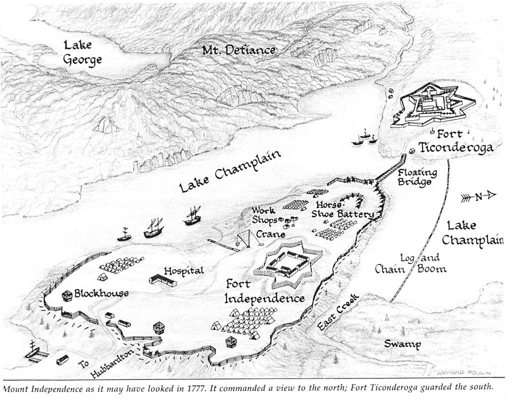
20 Edward G. Farmer, U.S.N. retired, of Orwell, are constructing an eight foot long model of the Mount.* Among the numerous "works" on the Mount, four are best known and most frequently described. The Shore or Water Battery stood at the north point a short distance from the lake and directly across from "Ti." It was a heavy masonry structure and its foundations are still visible, though like the other masonry on the Mount most of the stones have been carted away by neighboring farmers and lake dwellers during nearly two centuries of neglect. Farther up the hill was the Horseshoe Battery, a more pretentious enclosure meant to protect both the landing and the Shore Battery. On the long plateau top of the Mount and about half way along its axis, a Stockade Star Fort was erected covering more than an acre and enclosing barracks for 6oo men, with other brigades in barracks close by. There was also a new hospital. Protected by these considerable fortifications, on three levels, and with steep precipices on the west side along the lake, and on the east dropping steeply to the wide difficult morass of Vermont clay mud silt, and debris, threaded by East Creek, the colonists were justified in considering Mount Independence far less vulnerable than the old Fort on the opposite shore. But in September and October 1776 they constructed a fourth major preventive, the famous chain boom and bridge, crossing the more than 1500 feet between the north point landing of the Mount to a point just north of the nearest point on the New York shore, where the landing ground was not so steep. These barriers, firmly anchored, were expected to stop the British ships. Unfortunately the currents and the ice broke these up early in the winter and they had to be rebuilt the next spring. The use of "cassoons" or caissons, or piers, was something new in this frontier area. The heavy timbers, three or four feet thick and twenty-five feet long, were hewed out in February and made up in squares of four, chained together and filled in between by heavy stones; there were 22 of these piers. To get rhese into place vertically and hold them was a heartbreaking task especially when in May a heavy gale turned over the partly finished work. It was completed in June and the floating bridge, about twelve feet wide, was bjilt in sections chained between the piers. According to a colored picture map of the area recently published at the F ort49 the heavy chain boom with links an inch and a half thick, to stop the British ships, was stretched across a few hundred feet north of the bridge, doubtless to protect the bridge. Two engineers labored hard on the fortifications. Colonel Jeduthan [ 107 ] *Addenda, 107.
21 Baldwin was not a trained engineer; there were few in those days. But as a diligent practical and resourceful planner, layer-out and supervisor he erected works which won praise from the British when they took possession. His Diary,50 from July 6, I776 when he received orders from Crown Point, probably from General Schuyler, to proceed to Ticonderoga as Chief Engineer of the Northern Army, until July 5, I777, when the Americans evacuated the forts, is full of interesting detail. "As my business calls, I am on Mount Independence some days two or three times in a day." Among his many jobs was the road built from north end to south end of the Mount, somewhat more than a mile and shown by dotted lines in the Trumbull I776 map herewith, which also shows where the Hubbardton Military Road led southward from the Mount. We found no mention in Baldwin's diary of the road from the Mount to Rutland Falls; evidently Colonel Baldwin had one job to do, Colonel Barrett had another job to do, and neither minded the other man's business, though the two pieces of road tied together. In May I 777 Lieutenant Colonel Thaddeus Kosciuszko, the Polish patriot and engineer, arrived and joined at once in all the activity, as assistant to Baldwin. The Horseshoe Battery, which the British praised, was built by Kosciuszko. The chapter on Kosciuszko at Ticonderoga, in his biography,51 shows that most of his work during a two month stay was on the Mount. Unfortunately his rank as Baldwin's assistant, or perhaps a lack of frankness with his chief, discouraged his criticisms of Baldwin's ideas, and he failed to insist and prevail over Baldwin in what he considered failure to fortify Mounts Independence and Defiance adequately. The colonists had already experienced one threat of British attack. All through the spring and summer of I776, preparations were made for an expedition to attack the British in Canada by water, and under Benedict Arnold the fleet which the American troops had hastily constructed at Ticonderoga, Crown Point and Whitehall (twelve of* the fifteen "gondelos and galleys" were built at Whitehall) was assembled at Crown Point, the "First U.S. Fleet In Conflict,"52 and it left there on August 24. The details of this expedition and Arnold's resourcefulness in holding off the British when the Americans met defeat at Quebec and retreated up the lake, are highly creditable to Arnold. The failure of the Continental Congress to recognize his great ability and courage, shown also in his vital and heroic part at Saratoga, no doubt added to his frustration in having to give first place to Ethan Allen in taking the Fort the year before, and fanned [ I08 ] *Addenda, I o8.
22 his bitter resentment and later disloyalty. The Americans were forced to retreat nevertheless and on October I4, I776 the expedition was back at Crown Point, closely pursued by the British, who captured many of the American boats. The Battle of Valcour Island on October I I was one of the incidents in this expedition. In a letter describing Arnold's conduct Gates, who had appointed Arnold as fleet commander, Aug. 7, I776, wrote to Schuyler, "few men ever met with as many hairbreadth escapes in so short a space of time." On the same day that Arnold reached Crown Point he destroyed the works there and removed the troops and stores to Ticonderoga. The British General Carleton close behind landed a force at Crown Point which occupied both east and west shores of the lake in a plan to proceed against Ticonderoga. But "a great wind" blew up on the next day and for eight days it was impossible for the British ships to start out. A lucky gale of wind for the Americans, for in those eight days they made such headway in surrounding themselves with cannon that when the British renewed their attack on October 27, Carleton was forced to withdraw from the attack on Ticonderoga and he returned to Crown Point. The Americans were so strong and Carleton's force so small that he then decided to withdraw to Canada, the rear guard of the British Army leaving there on November 3 and the American troops taking over. Military historians credit the Americans for delaying the British army for a whole year in its attempt to pierce the heart of the colonies by way of the Hudson Valley. THE BIG MISTAKE: NOT FORTIFYING MOUNT DEFIANCE This close call from one attack by the British failed to bring reconsideration of the continued warning by Colonel John Trumbull and Benedict Arnold. Most disastrously and for what reason, other than plain stubbornness, it is now impossible to understand or to excuse, Mount Defiance, which was higher than Mount Hope, a block house north of the Fort, or Mount Independence, and directly overlooked Fort Ticonderoga from a height 65o feet greater, and commanded the outlet of Lake George and the entire American encampments and works, was not fortified. The latest U. S. map of Ticonderoga quadrangle, shows Lake Champlain as 95 feet above sea level, Fort "Ti." as I93 feet, Mount Independence as 300 feet, and the top of Mount Defiance as 853 feet. Gates and Schuyler insisted that the British with their cannon could not possibly climb the steep slopes to occupy that height. It would have taken Io,ooo men to man completely all the fortifications at Ticonderoga and the [ I09 ]
23
24
25 Mount, for they extended in a half circle two and a half miles long, and St. Clair, less than a month in command, when Burgoyne arrived, had only 2 8oo regulars and 900 new and undisciplined militia. "Around Mt. Defiance might be written a chapter of error and incompetence which, in the perspective of time, would seem almost unbelievable."53 General Horatio Gates, being chiefly in charge, may have been responsible for this failure, but Schuyler had been there to study the situation and by many is considered most at fault for his over-confidence, expressed in paragraphs quoted above, when he issued orders to occupy and develop the Mount, the year before, One of his nicknames was "the stubborn Dutchman." William L. Stone says54 that Stone's father was told by Colonel John Trumbull, then Adjutant General of the Northern Army, that Trumbull had pointed out to the other officers in 1776 that it "was an error" to assume the British could not scale this mountain. But these protests, strongly seconded by Arnold, deserve to be read in Trumbull's autobiography: "Our entire position formed an extensive crescent [more than three miles long] of which the center was a lofty eminence called Mount Defiance... which rises precipitously from the water to a height of six hundred feet... This important position had hitherto been neglected by the engineers of all parties, French, English and American." He then recounts his arguing the matter with his fellow officers at General Gates' mess table where his plea to fortify Defiance was ridiculed, upon which he obtained permission to fire cannon shot at Mount Defiance from the north point of Mount Independence. Against the opinion of Major Stevens the artillery officer, a twelve pound and six pound cannon were discharged, and both hit close to the summit. But the other officers still claimed "the summit was inaccessible to an enemy," whereupon he and Benedict Arnold, Colonel Wayne and other officers rowed across the lake and climbed to the top; "it was obvious to all that there could be no difficulty in driving up a loaded carriage... Our present position required at least ten thousand men and an hundred pieces of artillery, for its doubtful security... A small but strong post [on Mount Defiance] commanded by an officer who would maintain it to the last extremity, would be a more effectual and essentially a less expensive defense of this pass, than all our present extended lines." He then drew up a report on the matter with a diagram and figures as to the troops required for his project, compared to the existing plans. The resulting expense of the two systems "was as twenty to one nearly in favor of" the Mount Defiance scheme. His whole effort got no results, but the events of July 1777 proved all his predictions correct.55 * *Addenda, 110. [ I 10 ]
26 Another basic trouble was that Washington, Schuyler and the Continental Congress had assumed that the British at Quebec were preparing for attack on the Atlantic coast cities; they had not manned nor provisioned the Mount and Ticonderoga to take care of a large attacking force. Because of political pressure the Congress, which kept the appointment of officers in its own hands instead of giving this authority to Washington, appointed Gates to succeed Schuyler, much to Washington's disgust, so there was a series of commanders each jealous of the others, with St. Clair arriving to take charge only at the last minute. Just before Gates was superseded, he approved in April I777, Kosciuszko's earnest plea to fortify Mount Defiance, but Schuyler did nothing about it.56 The attitude of Congress and of Washington, to these contending generals, and the effect of these differences on the morale of the northern troops, was to weaken the preparations when word came of Burgoyne's invasion. Congress, in a panic when it awoke to the facts, authorized General Washington to call on the eastern states to raise additional regiments for defense of "Ticonderoga."57 BURGOYNE ' S INVASION After General Guy Carleton's failure to take Crown Point, and his retreat up the lake November 3, I 77 6, the period until the summer of I 777 was one of "watchful waiting" at the Mount. A large number of troops were kept in camp at Mount Independence and Ticonderoga as a precaution against attack from the north. Of the thousands of Americans who travelled our road, and camped on the Mount, several hundred died there in two epidemics, of typhoid and small pox. They lie in unmarked graves. Their hardships should never be forgotten. General Gates had reported to General Schuyler, October 4, I776, "Our communications are free and unmolested, and the eastern post and travellers are continually coming to Mount Independence by Otter Creek and the roads that lead from thence, no scouts of the enemy appearing to disturb them."58 November 5, writing again he mentioned that "there is an excellent bridge built over Otter Creek at Rutland, and a good road cut from Mt. lndependence."59 It was the invasion by General Burgoyne which brought the next and most important event in the history of Mount Independence. In February I777, a scouting party discovered that soo British troops were at St. Johns, just north of the Canadian line, and other British and Indians were already at Grand Isle. Obviously, the British were preparing to come up the lake and attack Ticonderoga again. [ I I I ]
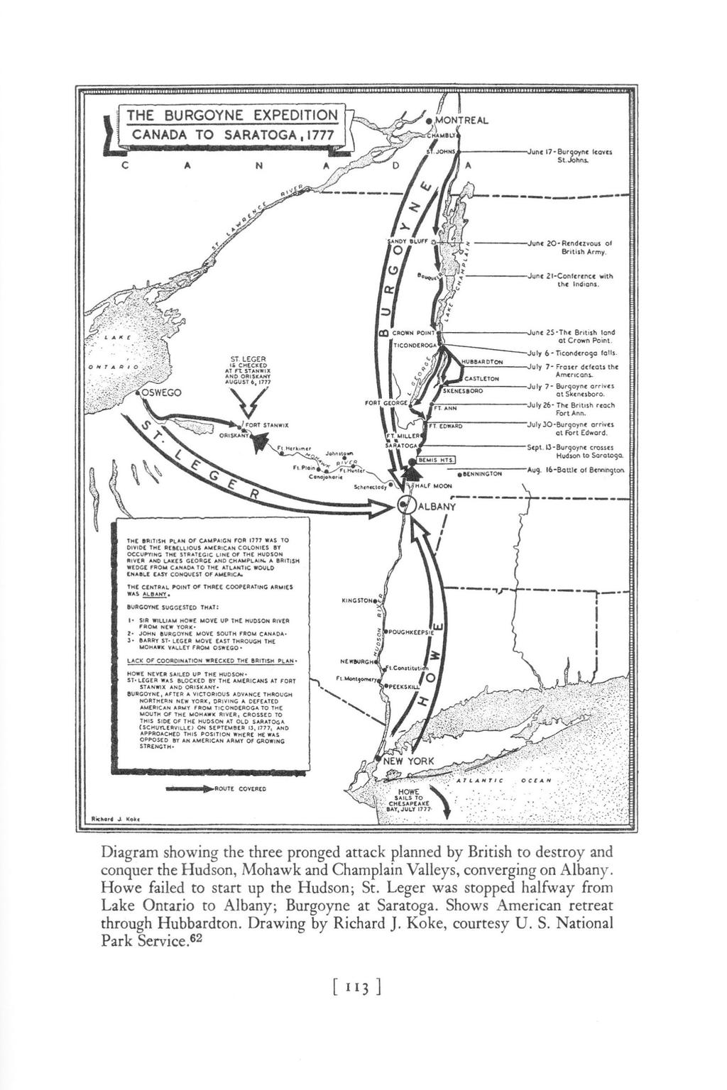
27 General Burgoyne, popularly called "Gentleman Johnny," and "Handsome Jack," who had a way with the ladies and had eloped with the Earl of Derby's lively daughter, had been appointed in March I777 and sent across the Atlantic to succeed the able Guy Carleton in command of the northern British army. He was a man of resourcefulness, with much experience, but his military and political judgement are by many considered inferior to Carleton's. Among his 4,200 German troops most were Hessians, secured by conscription from Hesse and Brunswick. They themselves got little pay, most of the money paid by the British for their help going to the Hessian government. Recent studies show that, including the officers, the army numbered 4,700 British soldiers, 4,200 Germans and a total of 9,400 men, including Tories, Canadians and Indians.60 With forty-two brass cannon the British and Germans arrived in Quebec in May 1777, and the army shortly started from St. Johns and reached the foot of Lake Champlain in June. A good popular account of Burgoyne and his expedition, with illustrations, appears in American Heritage, for June I His was part of a three pronged campaign, in which General Howe with another army was to strike north from New \ork, a third army under General St. Leger was to get up to Oswego on Lake Ontario by way of the St. Lawrence from Montreal thence east and the three armies were to concentrate on capturing Albany after conquering the Champlain Valley, the Hudson Valley and the Mohawk Valley. This is shown in the accompanying diagram, reprinted by courtesy of the Saratoga National Historical Park.62 It was not until June 5 that General Arthur St. Clair was assigned to command the Americans at Ticonderoga, arriving there on the I zth. He was dismayed to find a small force, half trained, poorly equipped and half armed. Everything was in poor condition to receive an attack. Further breast works were quickly thrown up at the foot of Mount Independence, and a battery constructed at the mouth of East Creek. The old French lines just west of Fort Ticonderoga were strengthened and guarded by a block house. The earthworks with guns on Mount Hope overlooking the marsh just west of the river flowing out of Lake George into Lake Champlain were reconditioned,63 with new batteries on the land just below, while another outpost was established at the saw mill on the river and one at the rapids at the outlet of Lake George. On July 2, I777, Colonel Seth Warner was sent by General St. Clair to get reinforcements. He wrote ahead from Rutland to the Vermont Convention in session at Windsor that "an army of Io,ooo [ I I 2 ]
28
29 veterans, one half of them German, had been collected in the province of Canada and attended by a formidable body of savages and a corps of Tories, was approaching the post at Ticonderoga." On July 5, he was back at Ticonderoga with the 900 militia just mentioned. General Riedesel, who commanded the Hessians, says 8oo men had arrived on the third. 64 So either Seth Warner mu st have left before the second, or met the men who "were on their way from New Hampshire with ammunition and provisions." Hiland Hall says they reached "Ti." on July But the position was already untenable. The British had already, July 2, captured the battery at Mount Hope, northwest of the Fort, and Riedesel and his troops had cut their way along the east shore, ready to surround the rear of the Mount. The Chief of Engineers, Lieutenant Twiss, had noted Mount Defiance, as a strategic point, unfortified. Within twenty-four hours, mostly under cover of darkness and without any cannonading from the Americans on Independence, his men cleared a narrow road up its steep flank, and on the morning of July 5 it was arrayed with heavy cannon on a shoulder about sixty feet below the summit, and it swarmed with red coats. According to publicity gi ven out in I950 at the opening of the new scenic toll road from Ticonderoga Village to the summit, "oxen dragge d eight 24-pounders and 8-inch howitzers to a point near the top, where their positions are still visible." 66 But* the circular distributed in I95 I-I952 to tourists visiting the summit states that six piece s of artillery were "dragge d up by ropes," and this is borne out by testimony at St. Clair's trial. Despite the 900 new soldiers just arrived, that evening St. Clair's council of war unanimously decided that the British could wipe out the American army, and that Mount Independence must be abandoned before daylight the next morning. No other course could have saved his army. EVACUATION OF THE FORT AND THE MOUNT We have not space for the details of Burgoyne's attack, told so completely and intere stingly in Lossing's hundred year old Pictorial Field Book of the Revolution,67 in Chapter 5 of Hoffman Nickerson's Turning Point of the Revolution,68 and in a chapter of Christopher Ward's two volume I952 account of the battles of the Revolution.69 The descriptions by the two ge nerals, Riedesel 70 and Fraser,71 who pursued the Americans to Hubbardton are full of details. And as this retreat was over our road we next gi ve an account of it. The Americans started their retreat from the Fort at 2 a.m. and from the Mount at 4 a.m. July 6. Was any artillery drawn over our *Addenda, I I 4 [ I I4]
30 "Military Road " on this retreat? "12 8 pieces of artillery, their shipping and batteaux, 1,74 8 barrels of flour, 70 tons of salt provisions, and a large drove of cattle," fell into Burgoyne's hands, and these would naturally and easily be transported by water to Skenesborough (W hitehall).72,73 One German and one British regiment were left in garrison at Mount Independence and "Ti." Evidently the British thought that this pursuit through the woods did not warrant delaying to take artillery. One of his officers 74 states that Fraser "at the head of a little more than half the vanguard and without any artillery (it had been impossible to take it along, although he had tried very hard) met z,ooo rebels, [i.e. at Hubbardton] which were in a very good position." He says also that Riedesel had the Yaeger Company and some grenadiers and chasseur battalions, indicating no artillery. Hadden says that Fraser was "without Artillery (which with the utmost endeavours it was impossible to get up)."75 But the Americans drew some cannon over the road. At Hubbardton, when Riedesel's Brunswick troops came to the rescue off raser' s corps, "The Americans seeing themselves surrounded... retreated, leaving behind them twelve pieces of artillery."76 This is confirmed by other records cited in Ward.77 Reidesel, early in the spring of 1777, had listed in his journal the American artillery at Ticonderoga and Independence, some of which, including "four four-pounders made at Cambridge, near Boston," had recently arrived and no doubt had been drawn to Lake Champlain over our road, i.e. via "Number 4 " and Rutland to Mount Independence, because it was so much shorter than any other. Part of the American garrison, "between four and six hundred effectives, with the worst of the sick also, went down the lake to Skenesborough, closely pursued by the English ships, commanded by Burgoyne himself. The rear of the American army, 2400 to z6oo men, retreating along the Military Road, was commanded by Col. Francis, pursued by General Fraser, with Boo or 900 of his men, followed later by Gen. Riedesel."78 As Nickerson says, "The country was heavily wooded. The road was a mere wagon track, cut through the woods the year before and probably unsuitable for guns."79 In spite of General Fraser's reference to it, as the "great road recently built by the Rebels," Ward calls it "but a pretense of a road... a mere wagon track, new, rough, rutted, and spotted with stumps of trees."80 Anyone who traces its course, winding, inadequately graded, and narrow enough [ I 15 )
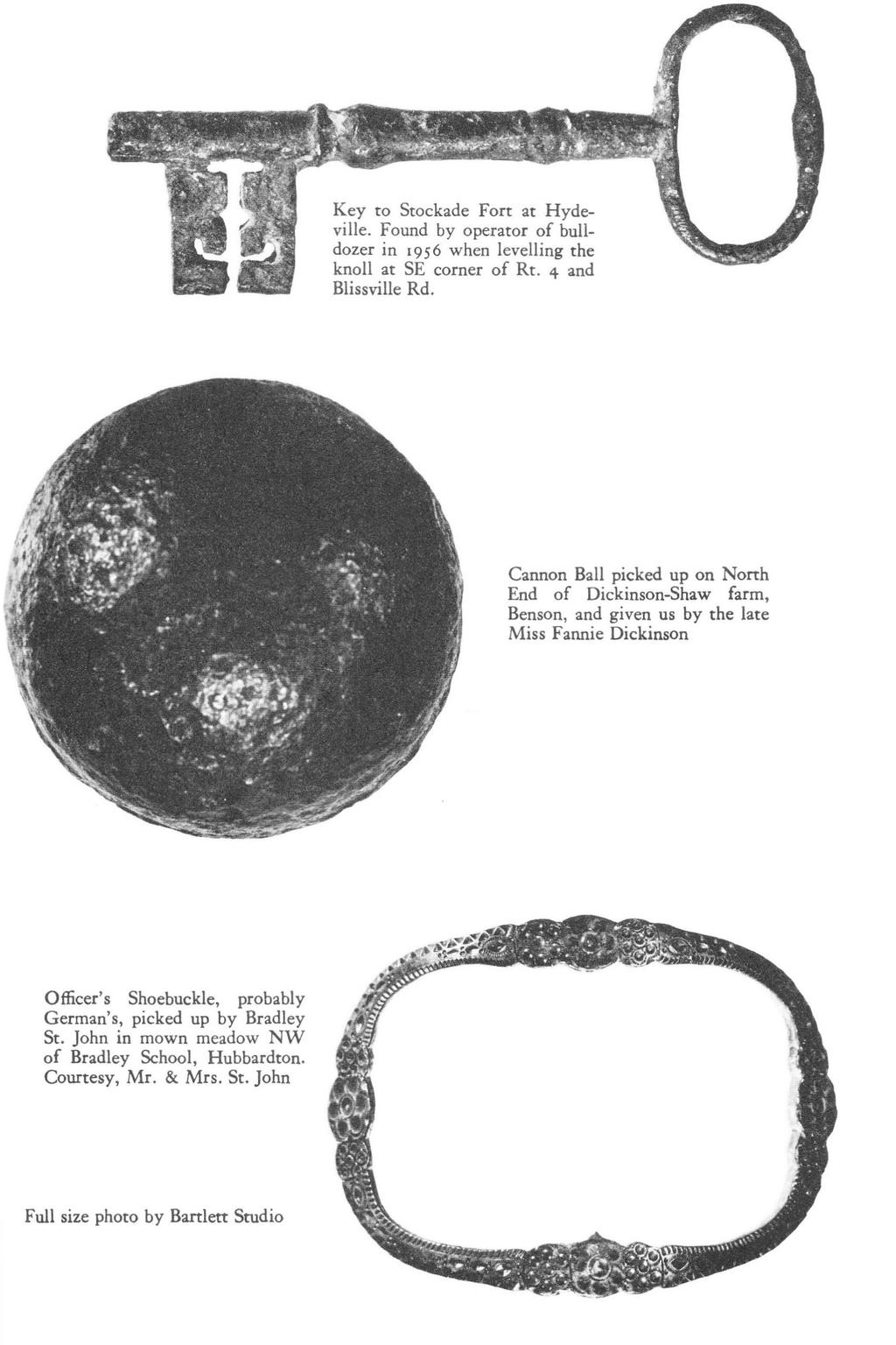
31 to just clear the tree trunks, can realize that it was not much of a road. We have not found statements that vehicles were drawn over it, but doubtless the flow of supplies and provisions required both ox-teams and packhorses. Several participants record that both July 6 and July 7 were "burning hot " days. The general disorder, confusion and hardship on this retreat across pan of Rutland County are described in a letter from soldier Cogan to General John Stark, dated Moses Creek, July r 7. Such a retreat was never heard of since the Creation of the world. I was ordered about five of the Clock in the afternoon to draw forty-eight Rounds pr man: afterwards, nine days allowance of provision, which I compleated about z of the clock in the morning, and about the time I got home the Tents were struck and all was ordered to retreat; but it was daylight before we got below your old house; such order surprised both officers and soldiers... they left all the Continental cloathing there; in short every article that belonged to the army; which if properly conducted might be easily saved... Our main body was within six miles of us, the Indians took & killed a vast number of our men on their Retreats; then was hurried at an unmerciful rate thro' the woods at the rate of thirty five miles a day, obliged to kill oxen belonging to the Inhabitants wherever we got them; before they were half-skinned every soldier was oblidged to take a bit and half Roast it over the fire, then before half done was oblidged to March,-it is thought we went roo miles for fear of seeing a Regular.... sr Lieutenant Digby says of the pursuit by Fraser's corps, "From the fort we [the British] were obliged to cross over a boom of boats... had they placed one gun so as the grape shot could take the range of the bridge... they would, in all probability, have destroyed all or most of us... We continued the pursuit the whole day without any sort of provisions... excepting one cow we happened to kill in the woods, which without bread, was next to nothing among so many for two days after, a few hours rest at night in the woods was absolutely necessary."82 Fraser's own account 71 is the most complete single detailed narrative of the pursuit. "We marched till one o'clock, in a very sultry day, over a continuous succession of steep and woody hills... very expeditiously from four in the morning, in order to harass their rear."83 According to Crockett, "the German dragoons were heavily loaded with equipment-high, heavy jack boots with large spurs, stout, stiff leather breeches, gauntlets reaching high up their arms and a hat with a tuft of feathers." We mention below the silver shoe buckle found in 1946 in West Hubbardton by Bradley St. John. "At his side each officer carried a tremendous broadsword and a carbine [ I!6]
32 was slung over his shoulder." 84 Riedesel, pronounced "Red Hazel " by the Americans, says all the German troops were provided for summer wear long light weight linen trousers, striped with blue and white.85 Sketches at the New York Public Library, drawn by a German soldier, show the German Dragoons equipped with heavy sword and carbine but with these pantaloons rather than leather breeches, boots or gauntlets. No doubt the British and German officers wore boots with buckles. A realistic account of the retreat, in fiction form, is given in Chapter 4 of Bruce Lancaster's Guns of Burgoyne.86 To save space we also omit the well known story of the Hubbardton battle, early in the morning of July 7, 1777, where the Americans suffered defeat because their army had divided in two, with General St. Clair's main force at or on the way to Castleton, and General Riedesel with his Chasseurs and 8o Grenadiers arriving just when Fraser's men were losing to the American rear guard. Colonel Fran cis was killed; the Battle Monument marks the spot. The Americans wisely disappeared to the south and east as soon as the battle ended, some over the hills into Florence and Whipple Hollow. Later and until recent years there was a passible road to Florence and another, noted below, ran east from Belgo Road. But most of the men including St. Clair and Warner reassembled and joined Generals Gates and Arnold in the defeat of Burgoyne at Saratoga three months later. St. Clair, tried by a court-martial the next year, was exonerated on the clear evidence that his retreat and defeat resulted from inadequate preparations by his superiors.42 Unfortunately for our pro ject there is in this report no detail as to the road or the march over it, except the short piece at the Mount shown on Trumbull's map above. St. Clair was highly thought of by Washington, was a member of the Continental Congress of , its President in 1787, and became the first Governor of the Northwest 1erritory The British General Simon Fraser, an able leader, was killed two months later at Saratoga, and in his dying hours was comforted by Baroness Riedesel, wife of his German fellow* officer, an attractive woman of notable fortitude and character who accompanied her husband through all the hardships of the campaign, and won the admiration of both sides. Pictures of all these officers appear in the U. S. Park Service Saratoga Battlefield booklet.62 A marker was erected at the Battle Monument by the Historic Sites Commission in 1954, and it has scheduled for dedication in 1959 a beautiful Museum building, of stone. The location of the Museum *Addenda, [ I I 7 ]
33 is strategic, for it overlooks the lowland and Sucker Brook just west of the plateau; some of the battle was fought on this lower ground. Many articles have been written on this battle but even yet the locations and sequence of some of it, are still uncertain. Mr. John P. Clement of Rutland is the chief living authority on the battle, and many hope for an elaboration of his recent Herald account.87 * AMERICAN ATIEMPT TO RETAKE TICONDEROGA It is not so well known that the Americans marched over the Mount Independence road again to make another attempt on Ticonderoga in September I 777. Its main ob jective was to cut off the rear of Burgoyne's army and to free the Americans who had been captured at Hubbardton. The German Lieutenant Du Roi says that eighteen American officers and 26o men had been made prisoners in the Hubbardton engagement and brought back to Ticonderoga.88 As General Burgoyne says in his own history of the campaign: "An attempt was made against Ticonderoga by an army assembled under Ma j. Gen. Lincoln [about 700 of them under Col. John Brown who rallied them at Pawlet; their route through Poultney, Castleton and East Hubbardton]89 who found means to march with a considerable corps from Huberton undiscovered, while another column of his force passed the mountains between Skenesborough and Lake George, 90 and on the morning of the I 8th of September a sudden and general attack was made upon the carrying-place at Lake George, Sugar Hill, Ticonderoga and Mt. Independence." The fort was defended by British Brigadier General Henry W. Powell. They tried four days, "and being repulsed retreated without having done any considerable damage."91 But Burgoyne should have admitted that Lincoln's men did succeed in freeing a hundred, most of the American prisoners still there, captured.225 British and German prisoners of their own, burned the boats at the dock, captured Mount Independence and the blockhouse on Mount Defiance, and destroyed cattle and the outer works. Their retreat was at daybreak, September 24. A bronze tablet at the Fort, erected by Massachusetts Society of the Colonial Dames in 1935, commemorates Brown's success. According to Nickerson they "retired eastward,"92 which means over the Hubbardton road, and evidently there must have been nearly rooo men on this late September march. Though the British kept possession of the Fort, its inhabitants were removed and the fort was dismantled soon after Burgoyne's surrender at Saratoga. In I78o I 78 I another British force from Canada under General Haldimand *Addenda, I I 8. [ I I 8 ]
34 was stationed there but the military history of the Fort and the Mount en ded in Fear of new attacks by the British hovering along the Lake wa s the chief reason for the building of Fort Warren at its two locations in Castleton. The next article will recount the building of the Hubbardton road, which connected Mount Independence with ea stern New England, and its route from Mount Independence through the Battlefield. NOTES 1 Walter Hill Crockett. Vermont, the Green Mountain Statt (New York, 192 1), II, Joseph L. Wheeler. "The Hubbardton Military Road " Rutland Herald, Aug. 24; Aug. 27; Aug. 29; Aug. 31, With map and airviews. 3 Phyllis Humphreys. "Tracing Old Roads," Rutland Herald, Sept. 2 5; Oct. 4; Nov. '' Joseph L. Wheeler. "Another Old Road, " Rutland Herald. April,, Describes route from East Poultney to Remington's Tavern. 5 Josiah F. Goodhue. History of Shoreham, (Middlebury, I 861), I Letter. Rutland Herald, Nov. 30, I934 Also, "Rebuilds Old Army Road at Castleton, " Nov. 2 2, I Frank Maranville, Los Angeles. Letter to J. L. Wheeler, Jan. 22, James D. Scott. Scott's Map of Rutland County (Philadelphia, 1854). 9 Lucius Eugene Chittenden, "The Capture of Ticonderoga, " Proceedings of the Vermont Historical Society III, 40-41; also separately (Rutland, 1872). 10 Goodhue. Shoreham, I 3, I6. 11 Daniel Pierce Thompson. The Green Mountain Boys, (Montpelier, I839). I74 12 H. Perry Smith and William S. Rann. History of Rutland County, Vermont, (Syracuse, I886), Ibid., so. 14 Ibid., 6 I9 15 Earle William Newton. The Vermont Story, (Montpelier, 1949), Epaphrus Bull. "Journal. " The Bulletin of the Fort Ticonderoga Museum, VIII (July, I948), 40. Also, The Narrative of Ebenezer Fletcher... 4th ed., (86 p. N.Y. I866). July 23, 24. Sept. 5, I957; July I, I Mary Fletcher Charlton. "The Crown Point Road. " Proceedings of the Vermont Historical Society. n.s. II (Dec. I93 I ), I6I-I93 19 James Duane Squires. "Old Number Four: Yesterday and Today. " Vermont Historical Society, News and Notes. (Jan. I959), William Howard Brown. "John Golfe and the Crown Point Road. " Historical New Hampshire, (Sept. I9 58). 21 William Howard Brown. Colonel fohn Goffe, (Manchester, N. H., I950). 22 Henry Francis Walling and Albert D. Hagar. Map of the State of Vermont, (New York, I 8 59). 23 Harold L. Bailey. '"Addison Branch Joins the Ghost Lines, Incorporated, " Vermont Quarterly, XX (Oct. I957) john Trumbull. Autobiography, (New York and London, I84I), John Trumbull. Autobiography. ed. by Theodore Sizer (New Haven, Conn., I9SJ). 26 Elias Hall. "The Old French Road"; letter in Rutland Herald, Jan. I7, I86J. ( I 19 )
35 27 "Fort Ticonderoga: a Short History." The Bulletin of the Fort Ticonderoga Museum, VII (July, 1945), Vermont Life, III (Autumn, 1948), Newton. The Vermont Story, New York Times, Aug. 20, F. E. Wolf, formerly "Historian of Poultney To wn, " letter to J. L. Wheeler, Sept. 28, Walter E. Johnson. ""We Came to Vermont for the Rest of Our Lives. " Vermont Life, VII (Summer, 1953), Ernest Walker of Contoocook, N.H., letter to J. L. Wheeler, Mar. 24, Clair Willard Perry. "Big Guns for Washington. " American Heritage, VI (Apr. 1955), Also, North Callahan. Henry Knox chapter 3 35 Roswell Bottum, History of the Town of Orwell, Vermont, (Rutland, 1881), Robert 0. Bascom. Historic Mount Independence. Hand's Cove Chapter, D.A.R. (Shoreham 1909). 37 Thomas B. Furcron. "Mount Independence, ," The Bulletin of the Fort Ticonderoga Museum, IX No. 4 (Winter, 1954), Claude Halstead Van Tyne. The War of Independence; American Phase, (Boston, 1929), Trumbull. Autobiography (1841 ed.) 33 Plate Carl Clinton Van Doren. Benjamin Franklin, (New York, 1938), F urcron. "Mount Independence "..., z. 42 "Proceedings of a Court Martial... of Maj. Gen. St. Clair, August 25, " Collections of the New York Historical Society for the Year 188o, Trumbull. Autobiography. (1841), Bulletin Fort Ticonderoga Museum. V. (Jan. 1939), Crockett. Vermont ii. 3-10, U.S. Geological Survey. Topographic map of Ticonderoga quadrangle This is four times the scale and with more accurate contours than the old Ticonderoga sheet of "Proceedings, Court Martial... of St. Clair. " 172; Map certified by Col. Kosciuszko. See also Eleanor M. Murray. "Resume of the Court Martial...", in Bulletin of the Fort Ticonderoga Museum VII, (July 1947), Includes the Court Martial map and key to the points shown. 48 Charles Wintersmith. "Plan of Ticonderoga and Mount Independence, including Mount Hope, and shewing the Rebel Works & Batteries... on July 6, likewise Sugar Hill... Surveyed and Drawn by Lieut. Charles Wintersmith by order of Lieut. Twiss, Commanding Engineer. " Photostat from original map, about 27 x 39 inches, at John Carter Brown Library, Providence. Also reproduced in Bulletin Fort Ticonderoga Museum. IX. No. 4 (Winter 1954), "All Roads Lead to Fort Ticonderoga. " Map 167'2 x 18 in. Fort Ticonderoga, n.d., not copyright. 50 Col. Jeduthan Baldwin. Rwolutionary Journal, ed. by T. W. Baldwin. (Bangor, Me. 1906). Main portion is in "Diary... " in Bulletin of the Fort Ticonderoga Museum. IV, (Jan. 1938), Miecislaus Haiman. Kosciuszko in the American Rwoution, (N. Y. 1943). 52 Edwin N. Rich. "First U. S. Fleet in Conllict-177 Years Later. " Whitehall Times, Sept. 24, A full illustrated description of the boats built there. 53 Warwick Stevens Carpenter. The Summer Paradise in History, (Albany, 1914),97 54 William Leete Stone. The Campaign of Lieut. Gen. fohn Burgoyne, and the Expedition of Lieut. Col. Barry St. Leger (Albany, 1877), Trumbull. Autobiography. Sizer ed., S6 Haiman. Kosciuszko, 17. [ I 20]
36 57 Crock en. Vermom II, 3 8-4o. 58 "Fort Ticonderoga... Letters. " Bulletin Fort Ticonderoga Museum. V, (Jan., 1939), /bid, Charles W. Snell, then Park Hisrorian, Saratoga National Historical Park. Lener ro J. L. Wheeler, Aug. 23, Reginald Hargreaves. "Burgoyne and America's Destiny. " American Heritage, VII, (June 1956), 4-7, Charles W. Snell. Saratoga National Historical Park, New York. National Park Service Historical Handbook Series No p. (Washingron, D. C. 1950). Map drawn by Richard J, Koke, from p. 2. See also beautiful colored bird's eye map by R. M. Chapin, Jr., "Campaign of 1777," in Time, July 7, 195L 63 Stephen H. P. Pel!. Letter ro). L. Wheeler, Jan. 10, 1950; says he could find no record that there ever was a fort on Mount Hope. The so-called "blockhouse " recently erected there as a commercial enterprise, is entirely a modern piece of construction, but a heavy battery was located there. 64 Max von Eelking, ed. Memoirs, and Letters and Journals of Major General Riedesel, during his Residence in America. (Albany, 1868), Hiland Hall. The History of Vermont from its Discovery to its Admission into the Union in 1791 (Albany, 1868), Fred Copeland. "New Scenic Highway, Road up Mount Defiance Traverses Handsome and Historic Country, " New York Timts, Oct. 8, 1950, II, Benson John Lossing. The Pictorial Field-Book of the Revolution (New York, 185o-1855) I, 131-q6. 68 Hoffman Nickerson. The Turning Point of the Revolution (New York, 1928), Christopher Ward. The War of the Revolution (New York, 195 2), I, Eelking. Memoirs... of Riedesel. 71 Simon Fraser. "General Fraser's Account of Burgoyne's Campaign on Lake Champlain and the Battle of Hubbardton. " Proceedings of the Vermont Historical Society. (1898) IJ. 72 Hamilton Child. Gazetteer and Business Directory of Rutland County, Vermont, for (Syracuse, 1881), James Murray Hadden. Journal and Orderly Books: A Journal Kept in Canada and uport Burgoyne's Campaign in1776 and 1777 (Albany, 1884), August Wilhelm Du Roi. Journal of Du Roi the Elder... tr... by Charlone S. J. Epping (Philadelphia, 191 1), Hadden. Journal, Stone. Campaign of Lieut. General fohn Burgoyne, Ward. War of the Revolution, I, Hadden. Journal, Nickerson. The Turning Point of the Revolution, Ward. War of the Revolution, I, Patrick Cogan. "Letter ro Gen. John Stark. " New Hampshire Provincial and State Papers VIII (Concord, 1874), Also, reprinted in Hadden. Journal, William Digby. The British Invasion from the North q77, with the Journal of William Digby... ed. by James P. Baxter. (Albany, 1887), Thomas Anburey. Travels Through the Interior Parts of America vols. (London, 1789), I, Crockett. Vermont II, Eel king. Memoirs of Riedesel l, 101. R6 Bruce Lancaster. Guns of Burgoyne (New York, 1939), John P. Clement. "New State Marker Clarifies Hubbardron Battle Story. " Rutland Herald, Oct. 9, [ I 2 I ]
 38-p. Contains a map p repared to show Lincoln's and Brown's separate routes to and from the lakes. See also, William B. Clarke. \"Col.")
37 88 Du Roi. Journal, Proceedings of the Rutland County Historical Society (I, 188 ), Peter Nelson. "The Barrie of Diamond Island," New York State Historical Association. Proceedings. (1922. XX) 38-p. Contains a map p repared to show Lincoln's and Brown's separate routes to and from the lakes. See also, William B. Clarke. "Col. John Brown's Expedition against Ticonderoga and Diamond Island, " New England Historical and Genealogical Register (1920. XX), 284, John Burgoyne. A State of the Expedition from Canada... (London, 1780) xciv. Contains a steel engraved map of the Champlain and Vermont area, and another of the Hubbard ron Barrie. 92 Nickerson, The Turning Point of the Revolution "Fort Ticonderoga: a Short History." Bulletin of the Fort Ticonderoga Museum VII. (July 1945), 28. This 4 page article is supplemented by 7 pages of letters from General Powell in Sept [ 122 ]
38
Day, 2ooth Anniversary Celebration, Saturday, October 10, 19 59, 24 p., ADDENDA
 ADDENDA Addenda, 93 Both the 1772 East Hubbardton road and Allen's bridle path along Pine Pond ran north from the present Route 4, which was the original Rutland-Whitehall road, and intersected the Crown
Dragging cannon from Fort Ticonderoga to Boston,
 1 Introduction On March 17, 1776, George Washington stood on Dorchester Heights alongside fifty-nine captured cannon high above the city of Boston, Massachusetts, and watched as British troops peacefully
American Revolut ion Test
 American Revolut ion Test 1. * Was fought at Charlestown, near Boston * Took place on Jun e 17, 1775 * Was a victory for the British Which Revolutionary war battle is described above? a. The Battle of
Benedict Alford August 26, 1716 After 1790 By: Bob Alford 2010
 Benedict Alford August 26, 1716 After 1790 By: Bob Alford 2010 Benedict Alford was the oldest child of Benedict Alford and Abigail Wilson. He was born August 27, 1716 in Windsor, CT, according to Windsor
by Timothy S. Corbett
 by Timothy S. Corbett HOUGHTON MIFFLIN by Timothy S. Corbett PHOTOGRAPHY CREDITS: Cover The Granger Collection, New York. Title Page North Wind Picture Archives. 3 The Granger Collection, New York. 4 The
Bell Ringer: The Declaration of Independence states people have the right to Life, Liberty, and the Pursuit of Happiness. What does this mean to you?
 Bell Ringer: The Declaration of Independence states people have the right to Life, Liberty, and the Pursuit of Happiness. What does this mean to you? Declaring Independence Road to Revolution One American
The Henry Knox Cannon Trail
 The Henry Knox Cannon Trail COMPILED FALL 2017; FOCUSING ON NEW YORK S PORTION OF THE TRAIL About Henry Knox and the Trail: As the Patriot Militia and Continental Army besieged Boston in late 1775, General
Why is the Treaty at Logstown in 1748 so important? What did it do?
 Student Worksheet A Shot in the Backwoods of Pennsylvania Sets the World Afire Worksheet 1: Focus Questions for "The Roots of Conflict" Instructions: Your group may answer these questions after the reading
Benedict Arnold, Mystery Man Danielle Ozanich Berkley Public Schools Berkley, Michigan
 Benedict Arnold, Mystery Man Danielle Ozanich Berkley Public Schools Berkley, Michigan Grade Level- 5th Grade Unit of Study- The American War for Independence Michigan Grade Level Content Expectations-
The following is a first hand account of the battle at Lexington and Concord. Read the passage, then answer the questions based on the source.
 BATTLE: LEXINGTON and CONCORD The following is a first hand account of the battle at Lexington and Concord. Read the passage, then answer the questions based on the source. SOLDIER EMERSON DESCRIBES THE
AMERICAN REVOLUTION Study Guide 2017: section 1: biographies
 AMERICAN REVOLUTION Study Guide 2017: section 1: biographies American Generals 1. He took the credit for winning Saratoga. He is most famous for riding a horse 140 miles away from Camden. 2. His early
Episode 7, 2012: Valley Forge Map
 Episode 7, 2012: Valley Forge Map Ruth Taylor: I'm Ruth Taylor. I'm the Executive Director of the Newport Historical Society in Rhode Island. It has about 10,000 objects, documenting Newport history from
North Iowa Airstream Club
 North Iowa Airstream Club 2018-19 Officers President Scott Jensen 1st Vice President Pat Shaw 2nd Vice President Jeff Peterson Corresponding Secretary Dave Shaw Recording Secretary Jodi Jensen Treasurer
The Sullivan Expedition of 1779 Battle of Chemung August 13, 1779
 The Sullivan Expedition of 1779 Battle of Chemung August 13, 1779 INTRODUCTION: In our study of the Sullivan Expedition in 1779, and Capt. Anthony Selin s Independent Company s role during this campaign,
Lesson Objectives. Core Content Objectives. Language Arts Objectives
 A Clever General 3 Lesson Objectives Core Content Objectives Students will: Describe George Washington as a general who fought for American independence Explain that General Washington led his army to
Military Episodes of the Revolutionary War
 Military Episodes of the Revolutionary War Burgoyne and the Hessians The British Secretary of State, Lord George Germain, was one of the most influential members of the British ministry, the body that
Liberty, Property and War. (Sermon at Beaverkill Community Church, 7/8/2018)
") Liberty, Property and War (Sermon at Beaverkill Community Church, 7/8/2018) There is no human liberty without property. If a man cannot keep the fruits of his labor, he is not free. He is, in fact, a slave
Liberty, Property and War (Sermon at Beaverkill Community Church, 7/8/2018) There is no human liberty without property. If a man cannot keep the fruits of his labor, he is not free. He is, in fact, a slave
Elyse: I m Elyse Luray, and I ve come to see Dan and Sharon s Front Street home for myself.
 Season 6, Episode 7: Front Street Blockhouse Elyse Luray: Our final story investigates a seemingly ordinary house with a potentially extraordinary past. February 8 th, 1690: a winter storm buries the frontier
Andrew Pepperell Fernald Veterans Stone Dedication. Fernald Family Cemetery ~ Goodwin Road ~ Eliot, Maine. Memorial Day ~ May 30, 2011
 Andrew Pepperell Fernald Veterans Stone Dedication Fernald Family Cemetery ~ Goodwin Road ~ Eliot, Maine Memorial Day ~ May 30, 2011 It was a bright day that greeted the town as it gathered at 9AM to witness
Washington Monument Written by Julia Hargrove
 Washington Monument Written by Julia Hargrove Illustrated by Gary Mohrman Teaching & Learning Company 1204 Buchanan St., P.O. Box 10 Carthage, IL 62321-0010 Table of Contents George Washington as a Child
The American Revolution. Timeline Cards
 The American Revolution Timeline Cards ISBN: 978-1-68380-024-8 Subject Matter Expert J. Chris Arndt, PhD, Department of History, James Madison University Illustration and Photo Credits Title Scott Hammond
Southern Campaigns American Revolution Pension Statements & Rosters
 Southern Campaigns American Revolution Pension Statements & Rosters Pension application of James Withrow S7945 Transcribed by Will Graves f37nc rev'd 1/24/11 &2/18/18 [Methodology: Spelling, punctuation
Mormon Trail, The. William Hill. Published by Utah State University Press. For additional information about this book
 Mormon Trail, The William Hill Published by Utah State University Press Hill, William. Mormon Trail, The: Yesterday and Today. Logan: Utah State University Press, 1996. Project MUSE., https://muse.jhu.edu/.
Boone County. and the Revolutionary War. By: Robin Edwards Local History Associate
 Boone County and the Revolutionary War By: Robin Edwards Local History Associate Typically the first places that come to mind when asked about the Revolutionary War are Lexington and Concord. After all,
Pea Ridge: Civil War Campaign in the West
 The Annals of Iowa Volume 52 Number 4 (Fall 1993) pps. 468-470 Pea Ridge: Civil War Campaign in the West Russell Johnson ISSN 0003-4827 Copyright 1993 State Historical Society of Iowa. This article is
Chapter 5 Lesson 1 Class Notes
 Chapter 5 Lesson 1 Class Notes The Lost Colony of Roanoke - England wanted colonies in North America because they hoped America was rich in gold or other resources. - Establish a colony is very difficult
How A Battle Is Sketched
 How A Battle Is Sketched In this article, written 24 years after the war for the children s magazine St. Nicholas, former Harper s Weekly sketch-artist Theodore R. Davis recollects the hazardous and inventive
American Revolution Test HR Name
 American Revolution Test HR Name 1) What crop made the British colonies viable and carried the nickname brown gold? a. Cotton b. Tobacco c. Corn d. Indigo 2) All of the following were reasons colonist
WHEN VERMONT WENT WEST*
 WHEN VERMONT WENT WEST* Vincent H. Malmström Migration is a phenomenon older than mankind itself. It is a thread that runs through the entire fabric of life, so interwoven with instinct as to be indistinguishable
Colonization and Revolutionary War Valley Forge
 Non-fiction: Colonization and Revolutionary War Valley Forge Colonization and Revolutionary War Valley Forge One of the hardest battles George Washington and his troops fought wasn't against the British.
CHAPTER 14 POST OFFICES
 CHAPTER 14 POST OFFICES Benjamin Franklin was appointed the first Postmaster General under the Continental Congress on July 26, 1775. Daniel Meeker was the first post master in Hubbardton in 1811. Seneca
[fn p. 60] State of North Carolina Macon County: Personally appeared before me John Howard one of the
![[fn p. 60] State of North Carolina Macon County: Personally appeared before me John Howard one of the](/thumbs/89/100338518.jpg "[fn p. 60] State of North Carolina Macon County: Personally appeared before me John Howard one of the") Southern Campaign American Revolution Pension Statements & Rosters Pension application of Nicholas Chapman S8193 fn62nc Transcribed by Will Graves 12/26/09 [Methodology: Spelling, punctuation and/or grammar
Southern Campaign American Revolution Pension Statements & Rosters Pension application of Nicholas Chapman S8193 fn62nc Transcribed by Will Graves 12/26/09 [Methodology: Spelling, punctuation and/or grammar
Station 1: Maps of the Trail of Tears
 Station : Maps of the Trail of Tears. According to the maps, how many total Native American Tribes were resettled to the Indian Lands in 8? Name them.. There were no railroads in 8 to transport the Native
COLONEL JAMES CRAWFORD,
 COLONEL JAMES CRAWFORD, The paper read at the meeting of the Historical Society of Lancaster County on September 2, 1898, prepared by J. W. Sheaffer, of Illinois, contains some statements not borne out
Southern Campaign American Revolution Pension Statements & Rosters
 Southern Campaign American Revolution Pension Statements & Rosters Pension application of George Rinker S32485 f40va Transcribed by Will Graves 7/2/12 [Methodology: Spelling, punctuation and/or grammar
Thomas Eames Family. King Philip s War. Thomas Eames Family in King Philip s War Josiah Temple The Thomas Eames Family.
 Thomas Eames Family in King Philip s War Josiah Temple The Thomas Eames Family was trying again to make a go of it. Thomas and his wife Mary had each been widowed and had children that they brought to
Teacher s Pet Publications
 Teacher s Pet Publications a unique educational resource company since 1989 To: Professional Language Arts Teachers From: Dr. James Scott, Teacher s Pet Publications Subject: Teacher s Pet Puzzle Packs
ADDRESS. Charles A. Lindbergh. New York, April 23,1941
 ADDRESS Charles A. Lindbergh * New York, April 23,1941 This address was delivered at 'an America First Committee meeting in New York City on April 23, 194L J.HERE are many viewpoints from which the issues
Arkansas Historic Preservation Program Civil War Sites and Battlefields in Arkansas PowerPoint Teacher Notes
 Arkansas Historic Preservation Program Civil War Sites and Battlefields in Arkansas PowerPoint Teacher Notes Slide 1: Slide 2: Slide 3: Slide 4: Slide 5: The Arkansas Historic Preservation Program (AHPP)
He took part in the expedition against Louisburg, in 1745, as Lieutenant Colonel of a Colonial regiment, and was in the same year made a Captain in
 Pound! In all ye Employments of Agriculture, there is scarce any Thing, which, under proper Management, yields more Advantage, or, perhaps, Amusement, than the Culture of Hops. See a fine Poem, Called
Conclude lessons from the Punic War
 Conclude lessons from the Punic War Your position is Rome (Sometimes you will be a consul and sometimes you will be the senate giving orders to the consul) Background: Rome is not yet the great power that
Southern Campaign American Revolution Pension Statements & Rosters
 Southern Campaign American Revolution Pension Statements & Rosters Pension application of Richard Hackney S6971 f32va Transcribed by Will Graves 1/30/14 [Methodology: Spelling, punctuation and/or grammar
Beers Atlas of Worcester, 1870, p.7 (partial) Supplement 2-A. (from photograph by author)
 Supplement 2-A. (from photograph by author)") Beers Atlas of Worcester, 1870, p.7 (partial) Supplement 2-A (from photograph by author) G. M. Hopkins, Atlas of Worcester, 1886, Plate 23 (partial) Supplement 2-B courtesy of Worcester Public Library
Beers Atlas of Worcester, 1870, p.7 (partial) Supplement 2-A (from photograph by author) G. M. Hopkins, Atlas of Worcester, 1886, Plate 23 (partial) Supplement 2-B courtesy of Worcester Public Library
Information Pages Each of the topics has an information page to read to your child.
 Thank you for purchasing from A Journey Through Learning. We hope that you enjoy our unit study entitled A Journey Through the 17 th and 18 th Centuries in America. Getting started is easy. First, take
Myron s Mysterious Monument. Myron A Locklin
 Myron s Mysterious Monument Myron A Locklin 1828-1864 A gravestone issued as a memorial for a Civil War soldier was found in a Montpelier back yard several years ago. It had been issued to the widow of
Lesson 3, Day 1: Vocabulary. In a dictionary, look up the following words which pertain to this week s period in history, and write their definitions.
 Lesson 3, Day 1: Vocabulary In a dictionary, look up the following words which pertain to this week s period in history, and write their definitions. formidable - sedition - desolation - 22 Lesson 3, Day
THE MYTH OF FORT POMFRET CASTLE
 THE MYTH OF FORT POMFRET CASTLE By MARVIN W. SCHLEGEL Assistant Historian, Pennsylvania Historical Commission, Harrisburg A CCORDING to several statements by Governor Morris of A Pennsylvania, Fort Pomfret
Transcontinental Railroad
 Name 1 Transcontinental Railroad Long Term Questions How have our leaders impacted the growth of the United States? (4.2.2) How did explorers and pioneers impact the growth of the United States? (4.2.1)
Death of Jacobus Westerfield
 384. Jacobus Van Westervelt, born September 07, 1712 in Hackensack, Bergen County, New Jersey; died Abt. December 1743 in Tappan, Bergen County, New Jersey. He was the son of 768. Jan Lubbert Van Westervelt
Mormon Trail, The. William Hill. Published by Utah State University Press. For additional information about this book
 Mormon Trail, The William Hill Published by Utah State University Press Hill, William. Mormon Trail, The: Yesterday and Today. Logan: Utah State University Press, 1996. Project MUSE., https://muse.jhu.edu/.
The General William Henry Harrison Trail through Portions of Vermillion County and Warren County, Indiana Written 11 October 2015 by Curtis L.
 The General William Henry Harrison Trail through Portions of Vermillion County and Warren County, Indiana Written 11 October 2015 by Curtis L. Older Five Probable Points Along the Harrison Trail, including
A section of a corner post, two of the horizontal cross members, and a piece of planking in their original positions. Note the doweled joints and the
 A section of a corner post, two of the horizontal cross members, and a piece of planking in their original positions. Note the doweled joints and the angle at which the corner post is cut. The piece of
The Bloody Reality of War - Wilson s Creek Image Analysis - Primary Source Activity
 The Bloody Reality of War - Wilson s Creek Image Analysis - Primary Source Activity Main Idea Students will use an image of the Battle of Wilson s Creek to understand more fully the events of the battle,
Early Modern History Copybook. GDI Basic Edition Grades K-3
 Easy Classical Press Early Modern History Copybook GDI Basic Edition Grades K-3 Easy Classical Writing Early Modern History Copybook GDI Basic Edition Grades K-3 By Julie Shields Easy Classical Writing
Southern Campaigns American Revolution Pension Statements & Rosters
 Southern Campaigns American Revolution Pension Statements & Rosters Pension application of James McDowell R6695 Mary Ann McDowell f26sc Transcribed by Will Graves 3/18/09: rev'd 10/29/09 & rev'd 11/14/16
Background Information for Teachers
 Background Information for Teachers Much of what we know about the historic capture of Fort Ticonderoga by Ethan Allen, Benedict Arnold, and the Green Mountain Boys on May 10, 1775, comes from the letters,
JOSEPH WEAVER, A VETERAN OF THE REVOLUTIONARY WAR HIS LIFE HIS FAMILY HIS HOME HIS SERVICE HIS RESTING PLACE
 JOSEPH WEAVER, A VETERAN OF THE REVOLUTIONARY WAR HIS LIFE HIS FAMILY HIS HOME HIS SERVICE HIS RESTING PLACE JOSEPH WEAVER IN THE SEASON WHEN WE CELEBRATE OUR INDEPENDENCE IT IS APPROPRIATE TO LEARN ABOUT
Map Exercise Routes West and Territory
 Routes to the West Unit Objective: examine the cause and effects of Independence Movements west & south of the United States; investigate and critique U.S. expansionism under the administrations of Van
ABIGAIL SPRAGUE BRADFORD
 154 LIFE OF ARCHIBALD GARDNER ABIGAIL SPRAGUE BRADFORD Abigail Sprague Bradford Gardner came of good old English stock. Her forefather, William Sprague, came from England in.the ship "Abigail" in 1628
Who were the Mormons and why did they decide to Head West?
 Who were the Mormons and why did they decide to Head West? Learning Objectives: To understand who the Mormons were and why they were unpopular in the East. To assess how successful their move West was
Captain Samuel Brady s Daring Rescue of the Stoops Family Near Lowellville, Ohio
 Captain Samuel Brady s Daring Rescue of the Stoops Family Near Lowellville, Ohio Researched By Roslyn Torella January 2014 Introduction One of the earliest tales that I could find documented that occurred
The Battle of Bunker Hill
 The Colonial Times The Battle of Bunker Hill 1775 A picture of the Battle of Bunker Hill. Based from an eyewitness, the Battle of Bunker Hill was another step from the battles of Lexington and Concord..
Moving Toward Independence. Chapter 5, Section 4
 Moving Toward Independence Chapter 5, Section 4 **Have you ever read the Declaration of Independence? We hold these Truths to be self-evident, that all Men are created equal, that they are endowed by their
Highlighting the Town of Croghan History
 -Hamlet of Beaver Falls -Hamlet of Belfort -Hamlet of Indian River -Hamlet of Naumburg -Village of Croghan -Beartown -Forest City -French Settlement -Gooville -Jerden (Jordon) Falls -Long Pong -Prussian
Larned Family Papers
 Larned Family Papers 1777-1822 7 vols., 0.5 lin. feet Contact: 1300 Locust Street, Philadelphia, PA 19107 Phone: (215) 732-6200 FAX: (215) 732-2680 http://www.hsp.org Processed by: Elizabeth Kata Processing
By Brian McConnell* Recently I received a transcribed copy of a letter sent on March 18, 1778 by Captain John
 An Exceedingly Fortunate Campaign, as described by Capt. J. MacDonald, 84 Regiment By Brian McConnell* Recently I received a transcribed copy of a letter sent on March 18, 1778 by Captain John nd MacDonald,
ETHAN ALLEN: VERMONT HERO
 BENEATH THE SURFACE ETHAN ALLEN: VERMONT HERO Tbe (l11ist used descriptio1/s oietbl1l/ Allen to make tbis portrait. Ethan Allen is without doubt the most famous Vermonter. Because he and his Green Mountain
April 2007 NewsLetter
 The Friends & Neighbors of Putnam Memorial State Park April 2007 NewsLetter The Ides of April In The Revolutionary War Bethel/Redding CT Henry Wadsworth Longfellow made a Boston patriot famous for all
Our Community Service. by William A. "Steve" Stephens. [Portions Taken from my report to the members of the Moffat Cemetery Assn.]
![Our Community Service. by William A. Steve Stephens. [Portions Taken from my report to the members of the Moffat Cemetery Assn.]](/thumbs/95/125400252.jpg "Our Community Service. by William A. Steve Stephens. [Portions Taken from my report to the members of the Moffat Cemetery Assn.]") Our Community Service by William A. "Steve" Stephens [Portions Taken from my report to the members of the Moffat Cemetery Assn.] We begin with some background. We became involved in the cemetery shortly
Our Community Service by William A. "Steve" Stephens [Portions Taken from my report to the members of the Moffat Cemetery Assn.] We begin with some background. We became involved in the cemetery shortly
The Mormons and the Donner Party. BYU Studies copyright 1971
 The Mormons and the Donner Party The Mormons and the Donner Party Eugene E. Campbell A busload of tourists, enroute from San Francisco to Salt Lake City, had stopped at the large stone monument near Donner
Table of Contents. Our Pennsylvania Story 5
 Table of Contents United States Political Map...........................................2 Pennsylvania Political Map...........................................3 Pennsylvania Physical Map...........................................4
COURT MARTIAL OF CAPTAIN JOSHUA BARNES
 COURT MARTIAL OF CAPTAIN JOSHUA BARNES Excerpts from the Court Martial of Captain Joshua Barnes Loyal American Regiment March 11-15, 1779 New York State Parks and Recreation Captain Joshua Barnes of the
Christian Street Rural Historic District
 Christian Street Rural Historic District Historic Tour No.6 in the Town of Hartford, Vermont Agricultural open space defines the Christian Street Rural Historic District, a 198-acre hamlet in the northeast
Vocabulary. In-Class Note-Taking. Why did Grant attack the town of Jackson? I thought he was trying to attack Vicksburg!
 Siege Grant s Canal Siege of Vicksburg Admiral David Dixon Porter General George Pickett Gettysburg Address Battle of Gettysburg Today s Thinking Focus Question: What ideals did Lincoln express in the
.by Express night & day. To The People of Texas and All Americans. Introduction
 .by Express night & day. To The People of Texas and All Americans Introduction Perhaps no other letter was as instrumental in the formation of a nation, as the February 24, 1836 letter penned by Alamo
The Making of a Nation #47
 The Making of a Nation #47 The national election of 1832 put Andrew Jackson in the White House for a second term as president. One of the major events of his second term was the fight against the Bank
NEVADA STATE BOARD ON GEOGRAPHIC NAMES
 NEVADA STATE BOARD ON GEOGRAPHIC NAMES MINUTES May 11, 2010 The meeting began at 10:30 AM at the Great Basin Science Sample and Records Library, 2175 Raggio Parkway, Reno. Board members and guests introduced
Mesa s Beginning. The Jones (Lehi) Company
 Company") Mesa s Beginning The Jones (Lehi) Company 1875 In late 1876 Mormon Church officials asked Daniel Webster Jones to lead a colonizing party south into Mexico. Jones stated he did not want the responsibility
Mesa s Beginning The Jones (Lehi) Company 1875 In late 1876 Mormon Church officials asked Daniel Webster Jones to lead a colonizing party south into Mexico. Jones stated he did not want the responsibility
Report of Gen. J.G. Martin of the Operations of his Command in Eastern Carolina, February 1864
 In early 1864, on direct orders from General Robert E. Lee, Confederate forces attempted to re-capture Union-held New Bern. Fighting ranged up and down the railroad from Newport to New Bern with action
James H. Merrill and the Cannon by the Door
 James H. Merrill and the Cannon by the Door Richard L. Berglund and Frank S. Harrington During the spring of 1861, the state of Maryland and the City of Baltimore were in turmoil. The election of Abraham
II Samuel 5:1-12 (tx: 6-10) THE LAME AND THE BLIND I. The historical story II. The spiritual significance INTRODUCTION
 THE LAME AND THE BLIND I. The historical story II. The spiritual significance INTRODUCTION") II Samuel 5:1-12 (tx: 6-10) THE LAME AND THE BLIND I. The historical story II. The spiritual significance INTRODUCTION How well do you know your American history? do you remember the great & decisive Battle
II Samuel 5:1-12 (tx: 6-10) THE LAME AND THE BLIND I. The historical story II. The spiritual significance INTRODUCTION How well do you know your American history? do you remember the great & decisive Battle
Who Built Stonehenge?
 Who Built Stonehenge? By History.com, adapted by Newsela staff on 08.22.17 Word Count 1,044 Level 1220L Stonehenge is one of the most famous places in the world. How it got there and what it was used for
Barbara Chisholm, War of 1812
 Barbara Chisholm, War of 1812 Anticipating the end of the War declared on Upper Canada on June 18, 1812, Barbara Chisholm reminds the people of her community of the events and the people the war has affected.
The Writing of the Declaration of Independence
 Eyewitnesses to the American Revolution The Writing of the Declaration of Independence A classroom play by Team HOPE Cast List John Adams.. member of the Continental Congress Chief Student Correspondent
Mormon Trail, The. William Hill. Published by Utah State University Press. For additional information about this book
 Mormon Trail, The William Hill Published by Utah State University Press Hill, William. Mormon Trail, The: Yesterday and Today. Logan: Utah State University Press, 1996. Project MUSE., https://muse.jhu.edu/.
In this packet, you will find
 Paul Revere QR Codes Bulletin Board Posters Pre-Reading Graphic Organizer Nonfiction Reading Passage Comprehension Questions PowerPoint Jeopardy Game Close Reading Text Constructed Response Question Character
Massachusetts Bingo Book
 ~A BINGO BOOK~ Massachusetts Bingo Book COMPLETE BINGO GAME IN A BOOK Written By Rebecca Stark Educational Books n Bingo 2016 Barbara M. Peller, also known as Rebecca Stark The purchase of this book entitles
Chapter 11, Section 1 Trails to the West. Pages
 Chapter 11, Section 1 Trails to the West Pages 345-349 Many Americans during the Jacksonian Era were restless, curious, and eager to be on the move. The American West drew a variety of settlers. Some looked
NOTES ON THE LIFE AND WORK OF ROBERT COLEMAN.
 226 Notes on Robert Coleman. NOTES ON THE LIFE AND WORK OF ROBERT COLEMAN. BY JOSEPH LIVINGSTON DELAFIBLD. ROBERT COLEMAN, b. Castlefinn, near Strabane, county Donegal, Province of Ulster, Ireland, November
Margaret (Peggy) Bolles Hathaway By: Bob Alford 2010
 Bolles Hathaway By: Bob Alford 2010") Margaret (Peggy) Bolles Hathaway 1774-1863 By: Bob Alford 2010 Margaret Bolles was born May 27, 1774 in what became the town of Waterford, Connecticut, on a farm located just north of New London. At the
Margaret (Peggy) Bolles Hathaway 1774-1863 By: Bob Alford 2010 Margaret Bolles was born May 27, 1774 in what became the town of Waterford, Connecticut, on a farm located just north of New London. At the
LINCOLN PUBLIC LIBRARY ARCHIVES/ SPECIAL COLLECTIONS
 LINCOLN PUBLIC LIBRARY Bedford Road, Lincoln, Massachusetts ARCHIVES/ SPECIAL COLLECTIONS Inventory List Flat Files in Vault Processed by William F. Carroll, CA January 2004 Drawer 1, Architectural Plans:
Wife of Anson Call
 A life sketch of Ann Mariah Bowen Call 1834 1924 Wife of Anson Call Ann Mariah Bowen Call was born January 3, 1834, in Bethany, Gennesse County, New York. In her early childhood she, with her parents,
KNOW YOUR ROOTS. A Family That Doesn t Know Its Past Doesn t Understand Itself. Volume IX Issue 1 DURLAND February 2004
 KNOW YOUR ROOTS A Family That Doesn t Know Its Past Doesn t Understand Itself Volume IX Issue 1 DURLAND February 2004 DR. JAMES THACHER DESCRIBES THE HARDSHIPS OF THE WINTER ENCAMPMENT AT MORRISTOWN *
Tarrant County. Civil War Veterans of Northeast Tarrant County. Edward Pompi Deason. Compiled by Michael Patterson
 Tarrant County TXGenWeb Barbara Knox and Rob Yoder, County Coordinators Copyright 2010-2012. All rights reserved. Civil War Veterans of Northeast Tarrant County Edward Pompi Deason Compiled by Michael
The Road to Revolution
 The Road to Revolution Unit 6 Vocab 1. Ad Interim Temporary 2. Annexation The act of adding or joining a territory to an existing one. 3. Artillery Mounted guns; cannons. 4. Bombard To attack often with
The 250 th Anniversary of Toms River. By: J. Mark Mutter, Township Historian PowerPoint By: Stacy Proebstle, Public Information Officer
 The 250 th Anniversary of Toms River By: J. Mark Mutter, Township Historian PowerPoint By: Stacy Proebstle, Public Information Officer A Semi-Quincentennial OR 250! 250 Years of What? The founding of our
Genealogy and NORTH CAROLINA Counties
 1 Genealogy and NORTH CAROLINA Counties An ancestor blessed with longevity could have been born in Rowan County in 1753. married in Burke County in 1778, fathered children in the counties of Burke and
The History of Poquonock: A Paper Recorded by. Carrie Marshall Kendrick ( ) on February 28, 1962
 on February 28, 1962") The History of Poquonock: A Paper Recorded by Carrie Marshall Kendrick (1883-1963) on February 28, 1962 INTERVIEWEE: Carrie Kendrick INTERVIEWER: n/a PLACE: unknown DATE: February 28, 1962 TRANSCRIBER:
The History of Poquonock: A Paper Recorded by Carrie Marshall Kendrick (1883-1963) on February 28, 1962 INTERVIEWEE: Carrie Kendrick INTERVIEWER: n/a PLACE: unknown DATE: February 28, 1962 TRANSCRIBER:
Midterm Review Guide #1
 Midterm Review Guide #1 Warned minutemen at Lexington Great speaker from Virginia King of England during the American Revolution. Leader of Sons of Liberty from Mass. Lawyer from Massachusetts Main author
St - Paul s - Church of the Loyalists in Halifax *
 St - Paul s - Church of the Loyalists in Halifax * Inside St. Paul s St. Paul s was founded by Proclamation of King George II in 1749 and church for the people and British garrison of Halifax until 1844