THE FCJRTIFIeATIONS OF ANCIENT ISRAEL AND JUDAH BC
|
|
|
- Stephanie Harper
- 6 years ago
- Views:
Transcription

1 THE FCJRTIFIeATIONS OF ANCIENT ISRAEL AND JUDAH BC
2 ABOUT THE AUTHOR AND ILLUSTRATOR SAMUEL ROCCA was born in Milan, Italy but now lives in Jerusalem with his wife and three sons. He served with the Israeli Defense Force, and has worked as a teacher and a curator at the Bible Lands Museum, Jerusalem. Having studied biblical and classical archaeology at undergraduate level at the Hebrew University of Jerusalem, he went on to complete his MA there, before researching his PhD on Herodian Judaea at Bar-llan University. Samuel has given papers at numerous international conventions, and written articles for several academic journals. ADAM HOOK studied graphic design, and began his work as an illustrator in He specializes in detailed historical reconstructions, and has illustrated Osprey titles on the Aztecs, the Greeks, several 19th century American subjects, and a number of books in the Fortress series. His work features in exhibitions and publications throughout the world.

3 FORTRESS 91 THE FORTIFICATIONS OF ANCIENT ISRAEL AND JUDAH BC SAMUEL ROCCA ILLUSTRATED BY ADAM HOOK Series editors Marcus Cowper and Nikolai Bogdanovic
4 First published in 2010 by Osprey Publishing Midland House, West Way, Botley, Oxford 0X2 OPH, UK rd St, Suite 219, Long Island City, NY 11101, USA Osprey Publishing Limited All rights reserved. Apart from any fair dealing for the purpose of private study, research, criticism or review, as permitted under the Copyright, Designs and Patents Act, 1988, no part of this publication may be reproduced, stored in a retrieval system, or transmitted in any form or by any means, electronic, electrical, chemical, mechanical, optical, photocopying, recording or otherwise, without the prior written permission of the copyright owner. Enquiries should be addressed to the Publishers. ISBN: E-book ISBN: Editorial by llios Publishing Ltd, Oxford, UK ( Cartography: Map Studio, Romsey, UK Page layout by Ken Vail Graphic Design, Cambridge, UK (kvgd.com) Typeset in Myriad and Sabon Index by Margaret Vaudrey Originated by United Graphic Pte Ltd, Singapore Printed in China through Bookbuilders DEDICATION This book is dedicated to my daughter Abigail, and my sons Yair and Daniel. ACKNOWLEDGEMENTS This book was made possible by the help of Dalit Weinblatt-Krauss, Bible Lands Museum Jerusalem, and the Israel Nature and Parks Authority. AUTHOR'S NOTE Many of the fortifications discussed in this book are done so within the context of the tell, an artificial mound formed from the accumulation and subsequent erosion of material deposited over long periods of time by the various human groups who occupied the site. A tell mostly consists of architectural material, such as stones, mud bricks and domestic implements such as pottery, which have been formed into various layers or strata, one on top of the other. A certain period can be identified by relating it to a stratum or group of strata. Thus Lachish Stratum III indicates the city that stood on the tell from c. 950 BC until 701 BC, when it was destroyed by the Assyrian army of Sennacherib. ARTIST'S NOTE Readers may care to note that the original paintings from which the A CIP catalogue record for this book is available from the British Library. colour plates in this book were prepared are available for private sale. All reproduction copyright whatsoever is retained by the Publishers. All enquiries should be addressed to: Scorpio Gallery, PO Box 475, Hailsham, East Sussex BN27 2SL, UK The Publishers regret that they can enter into no correspondence upon this matter. THE FORTRESS STUDY GROUP (FSG) The object of the FSG is to advance the education of the public in the study of all aspects of fortifications and their armaments, especially works constructed to mount or resist artillery. The FSG holds an annual conference in September over a long weekend with visits and evening lectures, an annual tour abroad lasting about eight days, and an annual Members' Day. The FSG journal FORT is published annually, and its newsletter Casemate is published three times a year. Membership is international. For further details, please contact: The Secretary, c/o 6 Lanark Place, London W9 1BS, UK Website: THE WOODLAND TRUST Osprey Publishing are supporting the Woodland Trust, the UK's leading woodland conservation charity, by funding the dedication of trees. FOR A CATALOGUE OF ALL BOOKS PUBLISHED BY OSPREY MILITARY AND AVIATION PLEASE CONTACT: Osprey Direct, c/o Random House Distribution Center, 400 Hahn Road, Westminster, MD uscustomerservice@ospreypublishing.com Osprey Direct, The Book Service Ltd, Distribution Centre, Colchester Road, Frating Green, Colchester, Essex, C07 7DW customerservice@ospreypublishing.com
5 CONTENTS INTRODUCTION 4 The Israelite settlement THE DEVELOPMENT OF THE FORTIFICATIONS 7 Iron Age I: from huts to houses - Iron Age MA: the United Monarchy Iron Age MB: the Divided Monarchy. Iron Age MC: Judah alone THE PRINCIPLES OF DEFENCE: IRON AGE II 19 City planning - The elements of defence TOUR OF THE SITES 25 The Northern Kingdom of Israel - The Southern Kingdom of Judah - The Negev The Judaean Desert, the Judaean Hills, and Shephelah THE LIVING SITES 40 In time of war THE SITES AT WAR 48 Sennacherib's campaign in Judah, 701 BC AFTERMATH 55 THE SITES TODAY 60 CHRONOLOGY 62 BIBLIOGRAPHY 63 INDEX 64

6 THE FORTIFICATIONS OF ANCIENT ISRAEL AND JUDAH BC Rameses III and the Sea Peoples. This illustration shows part of the inscriptions from Medinet Habu, a temple built for Rameses III at Thebes in Egypt. It shows the Philistine ships engaged in a naval battle with the Egyptian fleet. (Author's collection) INTRODUCTION The subject of this book is the fortifications erected by the Israelites in the Land of Israel between 1200 BC, when they first began to settle there as a people, and 587 BC, when Jerusalem, the capital of Judah, fell into the hands of Nebuchadnezzar, of Babylon, and its population was deported to Babylonia. Before the Israelite settlement the Land of Israel had a very long history. Archaeologists divide the Biblical Period, or the earlier history of the Land of Israel, into two main phases: the Bronze Age ( BC), known also as the Canaanite Period after the main ethnic groups that dominated the Land of Israel, and the Iron Age ( BC), known also as the Israelite Period. This book will mainly focus on the latter. 4
 Archaeological artefacts can best be understood when related to other sources, particularly written ones.")
7 room house'. This type of building was the main characteristic of Israelite settlements throughout the Iron Age. (Author's collection) Archaeological artefacts can best be understood when related to other sources, particularly written ones. The latter for the period in question chiefly comprises the Bible (in particular the Book of Judges, the First and Second Book of Samuel, and the First and Second Book of Kings), but the Assyrian and Babylonian annals (written in cuneiform characters), and various epigraphic material (such as the stele of Mesha, king of Moab, the Siloam inscription and various ostraca - fragments of pottery or stone) are no less important. Sometimes the archaeological/epigraphical evidence fits with the Bible, sometimes it contradicts it, but more often than not the two work together to form a more complete picture. A schematic plan of a four-room house. The house has a square overall plan. The three front rooms are built at right angles to the back room. The central space served as courtyard. (Dalit Weinblatt-Krausz) The Israelite settlement Iron Age IA ( BC) saw the decline of Egyptian control of the Land of Canaan. Around 1200 BC, the Late Bronze Age world was shattered by a series of cataclysmic invasions. The huge Hittite empire in Asia Minor was overrun by the Sea Peoples, who also threatened mighty New Kingdom Egypt until Pharaoh Rameses III defeated them on sea and land, an achievement celebrated on the walls of the temple he erected at Medinet Habu. Following his victory over the Sea Peoples, Rameses III made them subjects and settled many of them (chiefly the Philistines) along the Canaanite coast. The Tjeker, another of the Sea Peoples, settled in the Canaanite city of Dor further north. The Canaanites maintained their presence in the plains, as well as in most of the fortified cities scattered around the

8 The settlement of the tribes The archaeological evidence (chiefly, the 'four-room house' and pottery such as the so-called 'collared rim jar') points to a distinctive identity among the early Israelite settlers, as well as to the gradual settlement of nomadic tribes in several locations scattered around the country. These include the area around Mount Meron in Upper Galilee, in the hills of Western Galilee, in the captured Canaanites cities of Hazor and Dan, and in lower Galilee, mostly in the hilly region of Shefar'am in the area of the tribe of Zebulun. The greatest numbers of settlements are around Ephraim and Manasseh; between Shechem and the Jezreel Valley a 100 sites have been surveyed. In the settlement area of Benjamin, some 12 settlements have been identified, including Tel en-nasbeh, the Biblical Mizpah, and Tell el-full, the Gibeah of Saul. In Judah, the Hebron Hills and the Shepelah of Judah, there were few settlements (Hebron, Beth Zur, Tell Beth Mirsim). Around Jerusalem, the only Israelite settlement so far surveyed and excavated is Giloh. Very few settlements have been discovered in the south; in the Arad and Beer-sheba valleys the most important settlements were Tel Masos, Tel Esdar and Tel Beer-sheba. However, intensive settlement occurred farther south in the Negev highlands. In Transjordan, many settlements surveyed in Gilead may be linked to the half-tribe of Manasseh. The Land of Israel during the period known as Iron Age I, or 'the period of the Judges' ( BC). 6

9 country. The Philistines developed a confederation of city-states, notably Gaza, Ashkelon, Ashdod, Gath and Ekron, and erected settlements encircled by walls. The Israelites began to settle alongside the Canaanites and Philistines between 1200 and 1005 BC, at first in the northern part of the country and in the central hills. The Bible (Joshua 15: 63, 16: 10 and 16: 11-18, and Judges 1: 21-35) states that the Israelite tribes settled after conquering the country under the leadership of Joshua. Later, Judges (local leaders) were elected by each tribe or group of tribes to fight the Canaanite city-states, and hostile tribes such as the nomadic Midianites, the Moabites and the Ammonites, who together with the Edomites settled in this period in the eastern part of Transjordan. Most of the Judges, with the exception of Othniel, came from the northern tribes. Only towards the end of the period were the Israelite tribes powerful enough to resist the Philistine city-states, under Samson from the tribe of Dan. By the end of the Period of the Judges, the Israelite tribes had settled in the central areas too. At this stage, the tribe of Dan was in the extreme north of the country, the tribes of Asher and Naphtali had settled in Upper Galilee and the tribes of Zebulun and Issachar were in Lower Galilee. In the central part of the country the tribe of Manasseh was in the northern part of Samaria, while the tribe of Ephraim had settled in the southern part. The tribe of Benjamin had settled in the area around the Canaanite enclave of Jebus, the future Jerusalem. In the Transjordan were settled (from north to south) the tribes of Manasseh, Gad and Reuben. In southern Transjordan were settled the tribes of Judah in the area of Judaea, and of Simeon further south. THE DEVELOPMENT OF THE FORTIFICATIONS Iron Age I: from huts to houses During the period known as Iron Age I, the Period of the Judges, the Israelites passed from a semi-nomadic society of shepherds, with a loose tribal organization, to a settled society of farmers. This is reflected in the design A four-room house in the City of David, Jerusalem. The two rows of pillars mark the outline of the internal courtyard. (Author's collection) 7
 A reconstruction of Tell el-full Biblical Givat Shaul ('Saul's Hill').")
10 An urban plan of Tel Masos, Stratum II. This plan depicts the central settlement, which forms part of a cluster of enclosures. The external walls of the dwellings form an outer defensive belt for the settlement. (Dalit Weinblatt-Krausz) A reconstruction of Tell el-full Biblical Givat Shaul ('Saul's Hill'). (Author's collection) and development of their settlements. According to the archaeologist Ze'ev Herzog, it is possible to distinguish five main types. The first type of settlement comprises huts and pits. These settlements are mainly found in the northern valleys, the hill country, the Sharon Plain and the Negev. The structures consist of pits that were dug for water and as ovens. It seems that at this stage the population still lived in tents or huts. There is no clear indication of any system of defence. However, the fact that these pits are concentrated together may indicate that the settlers favoured a closer settlement, making it easier to defend. The second type of settlement, comprising clusters of pens, developed at a slightly later stage. The best example is Giloh, south of Jerusalem. These enclosed pens, which probably hosted sheep or goats, also contained a single dwelling built of stone. At Giloh five such family pens have been excavated. The pens probably served to protect both the dwellers and their herds. 25m The third type of settlement is the enclosed settlement. Most of the Israelite settlements were of this type, and examples have been excavated and surveyed all over the country - in Upper Galilee at Horvat 'Avot, in Western Samaria at Izbet Sartah, in the Judah region, in the Negev, in the area of the wilderness of Beer-sheba, at Hatira, Refed and Rahba, and at Tel Esdar. The best example from the northern Negev is Tel Beer-sheba, Stratum VII. This type of settlement consists of four-room houses encircling a central open area (probably used for herding animals at night); the outer walls of the dwellings form a defensive ring. Many of these settlements are adapted to the contours of the respective sites, and the houses are uniform in size. The families and the tribes would be responsible for the defence of such settlements from semi-nomadic tribes such as the Ammonites, Moabites, Edomites and Amalecites, but could do little against any regular armed force.
11 The two remaining types of settlement developed from the enclosed settlement. In the fourth type, Israeli settlement villages, there is no central open area. This settlement, which probably appeared towards the end of Iron Age I, indicates that the Israelite tribes had by now evolved from shepherds to farmers. Their decreasing dependence on herds of sheep and cattle allowed the central area of the settlement to be used for building further dwellings. Israeli settlement villages have been excavated at Ai and Beth-Shemesh. The fifth type of settlement, clusters of enclosures, comprised separate enclosed settlements that were built close to each other. The best example is the settlement of Tel Masos, which extended over an area of 50,000m 2. This settlement consisted of three groups of separated enclosed settlements, each located on a nearby slope. An interesting characteristic is that it has no separate peripheral defence, instead relying solely on the outer walls of the dwellings in each of the settlements. The four-room bouse The main characteristic element of Israelite settlements throughout the Iron Age is the four-room house, which the archaeologist Shmuel Yeivin termed the 'Israelite house'. According to Shiloh, its dispersal corresponds to areas of settlement of the Israelite tribes. The four-room house has clearly defined features, namely an oblong (occasionally square) overall plan, with a wide room at the rear. The three frontal chambers are built at right angles to the back room. The back room provides the main space, with solids walls enclosing it. A row of pillars or a wall separates the lateral front spaces from the central courtyard. That the central space was used as a courtyard is indicated by the fact that it was paved with beaten earth, while the other lateral spaces and the wide room at the back could be paved with stone. The row of pillars indicated that the space served to protect the family herd, or other domestic animals possessed by the family that owned the dwelling. It seems that there was a second storey, at least on top of the back room, and probably less often on the side chambers also. The best examples of Iron Age I four-room houses come from Tel Masos, Giloh and Izbet Sartah. According to Israel Finkelstein, the shape of the four-room house indicates that the plan developed from a tent or hut with an enclosed courtyard on the front, which is still used by Bedouins living in the Sinai area. A plan of of Tell el-full, Biblical Givat Shaul. It seems that the building was a square structure with a central courtyard, with four huge square towers defending the corners. (Dalit Weinblatt-Krausz) Iron Age IIA: the United Monarchy During the period known as Iron Age IIA ( BC), under the United Monarchy rule of Saul, David and Solomon, the material culture of the Israelites witnessed a clear development. The Israelites passed from a loosely organized tribal confederation to a modern, centralized state. The various tribal Judges were superseded by a king, albeit with limited powers. Moreover, the Israelites not only completed their conquest of the Canaanite cities, but dominated their Philistine neighbours in the south, the states of Moab, Ammon, and Edom in the east, and the various Aramaic principalities in the north. They also succeeded in establishing friendly ties with the Phoenician city of Tyre. Saul began the overall process, but it was David who established the capital of the united kingdom at Jerusalem, making it not only the political but also the religious centre of the Israelite state. 9
 BELOW The 'seal of Jonathan', depicting a winged sphinx, a motif characteristic of Phoenician artists. The writing on the seal is in Hebrew.")
12 ABOVE The seal of Shemah, 'servant of Jeroboam'. The seal is in Hebrew and depicts a lion. The name Jeroboam probably refers to King Jeroboam II of Israel. (Author's collection) BELOW The 'seal of Jonathan', depicting a winged sphinx, a motif characteristic of Phoenician artists. The writing on the seal is in Hebrew. (Courtesy of the Bible Lands Museum, Jerusalem, BLMJ Seal 1841) Around 1050 BC Samuel of the tribe of Ephraim, probably the most important tribe, was appointed Judge. He led the Israelites to victory against the Philistines at the battle of Mizpah, but was unable to unite the tribes. Thus, around 1047 BC Samuel appointed Saul ( BC) from the tribe of Benjamin as the first king of Israel. He defeated the Ammonites under their king Nahash, and then the Amalecite tribes, capturing their king Hagag. The Israelites defeated the Philistines again at Michmash, but it was indecisive, and Saul would have to fight them throughout his reign. In 1007 BC, Saul and his son and heir Jonathan were defeated and killed at the battle of Mount Gilboa fighting against them. During his reign, Saul established his headquarters at Gibeah, not far from the Canaanite city of Jebus. The American archaeologist William Foxwell Albright, who excavated the site, discovered a small fortress, square in shape, with four towers at the corners. This small fortress is quite different to the contemporary four-room house, and perhaps stresses Saul's different status as king of Israel. The death of Saul brought civil strive between the tribes. Most of the northern tribes, including Benjamin, Ephraim and Manasseh, appointed Saul's son Eshba'al as their king. However, the tribe of Judah chose David from Hebron ( BC). David's army, under the command of Joav Ben Seruja, defeated the army of Eshba'al, and the Israelite tribes coalesced around the charismatic leader. David conquered the Canaanite enclave of Jebus (Jerusalem), and established his capital there. He then began a series of campaigns: against the Philistines, in Transjordan against the Moabites, the Ammonites, conquering their capital Rabath Ammon, and against the Aramean principalities of Aram Zoba and Damascus. He also brought Edom to submission. David's last years were marred by civil unrest and the rebellion of his third son Absalom, and that of Sheba Ben Bichri. When he died in c.967 BC, David was succeeded by his son Solomon ( BC). He erected the Temple, as well as a huge palatial complex, in the city of Jerusalem. However the main reforms of King Solomon were administrative. He neutralized the strength of the tribes, and created a modern kingdom based on 12 administrative districts, each commanded by an official chosen by the king. Each officer was moreover responsible for tax collecting and a manpower levy for military service or work on the king's building projects. It seems that Solomon did not erect any fortifications in the 12 districts. However, the Bible (First Book of Kings 9: 15, 17) mentions that he erected a city wall in Jerusalem, which defended the old Canaanite city, and the Temple Mount. Solomon did fortify the cities of Hazor, Megiddo and Gezer. According to Yigael Yadin, the Solomonic cities were characterized by casemate walls 10

13 The Land of Israel during the period known as Iron Age II, after the division of the kingdoms of Israel and Judah c.922 BC. 11

14 and huge six-chambered gates. According to the Bible, the purpose of these fortifications, together with the cities of Beth-Horon, Ba'alath and Tadmor, was to function as 'store cities', and to garrison the king's chariots and horsemen. He also built huge palaces and the First Temple at Jerusalem, and in a joint venture with the Phoenicians of Tyre created a harbor at Etzion Geber, near modern Eilat. At Tel el-kheleifeh, Nelson Glueck excavated a small fortification with casemate walls, which he dated to Solomon's reign. The most interesting structures that can be dated to the period of the United Monarchy are a series of enclosures in the central Negev Highlands at 'En Kadesh, Atar Haro'e, Hurvath Haluqim, Hurvat Rahba, Hurvat Ketef Shifta and Ramat Matred. These structures, which may be administrative centres or small fortifications, suggest an Israelite penetration into this area, probably as a result of economic prosperity. An ivory plaque depicting a cherub. Plaques like this one typically decorated furniture. The cherub is another characteristically Phoenician artistic motif. (Courtesy of the Bible Lands Museum, Jerusalem, BLMJ 3428) 12

15 Iron Age IIB: the Divided Monarchy After the death of Solomon, the United Monarchy collapsed. In 926 BC Pharaoh Shishaq campaigned in the Land of Israel, destroying many of the settlements. Moreover, the northern tribes seceded from the Davidic kingdom, probably in resentment at Solomon's expenditure and his tight control. Thus while the southern tribes of Judah, Benjamin and Simon coalesced around Rehoboam ( BC), the northern tribes elected Jeroboam ( BC) as king. The secession was sealed by the erection of alternative religious centres at Dan and Bethel. According to the Second Book of Chronicles (11: 5-12), Rehoboam built a series of fortifications in the areas of Judah and Benjamin. Some archaeologists date the main fortifications of Israelite Lachish to Rehoboam, pointing to its six-chambered gate similar to the Solomonic gates of Megiddo, Hazor, and Gezer. His successor, Abijah ( BC), attempted to conquer the border area between Israel and Judah. Asa ( BC) continued his father's policy, and around 885 BC began a war against Baasha ( BC), the king of Israel, in alliance with the Aramean king Ben Haddad I (who razed Hazor to the ground). As consequence of the war, Asa fortified the border cities of Mizpeh and Ramah (First Book of Kings 15: 16-22). Baasha's defeat saw one of his generals, Omri (r BC), become king of the Northern Kingdom of Israel. The Omrides would rule with stability for more than 40 years. Omri set up a new capital at Samaria. It was Omri's son Achab (r BC) who made the kingdom a regional power. Achab married the Tyrian princess Jezebel, forging an alliance with the Phoenician city of Tyre, and began a series of successful wars against various Aramean princes between 855 and 850 BC and against the Assyrian king, Shalmanezer III, whom he defeated at the battle of Kurkar. Various fortifications were erected by the Omrides. The cities of Samaria, Hazor and Jezreel have similar rectangular plans, and header and stretcher ashlar stones were used to reinforce the brick walls. Solomonic casemate walls were common at first, but the clash with Assyria led the Omrides to introduce a new type of wall - a solid, thick one featuring inset and offset sections, Gihon Spring Hezekiah's Tunnel This plan depicts Jerusalem on the eve of Nebuchadnezzar's conquest in 586 BC The city includes the City of David and the Temple Mount to the east, and the 'Broad Wall', which encircled the Mishneh Quarter to the west. The site of the Gihon Spring and the course of Hezekiah's Tunnel are also shown. (Dalit Weinblatt-Krausz) NEXT PAGE: THE CITADEL OF MEGIDDO AT At this time most of the Solomonic structures were still in use. The city was by now surrounded by a solid inset and offset wall A monumental six-chambered gate (bottom right) stood in the northern part of the site. Although Palace 1723 dates to the Solomonic period, Palace 338, and the pillared Southern and BEGINNING OF THE OMRIDE PERIOD Northern Stable complexes date to the Omride period. The water system at Megiddo (shown in the bottom left) consisted of a shaft leading down to a horizontal tunnel, which in turn led to a natural spring cave on the edge of the site.

16 14 The citadel of Megiddo at the beginning of the Omride period
17 15
18 the purpose of which was to withstand the powerful Assyrian besieging machines. City gates became smaller, moving from the six-chambered gate to four-chambered ones. However, gates were now reinforced by an outer mono-chambered gate. Inside the strongholds various administrative and storage buildings were erected, such as those excavated at Samaria, Hazor and Megiddo. Omride Megiddo IVA presents a gate complex together with an inset and offset wall, a palace (Palace 338), and two huge storage complexes, which were probably used for Achab's chariots and horsemen. At the beginning of his rule, King Jehoshaphat of Judah ( BC) decided to fortify his kingdom against a possible Omride attack. According to the Second Book of Chronicles (17: 1-19), he placed garrisons in all the fortified cities of Judah and in the cities of Ephraim. Later, however, as a consequence of the Omride successes, Jehoshaphat decided to ally himself with the Omride kingdom against the Arameans. During Jehoshaphat's rule, Judah was divided into 12 administrative districts (Book of Joshua 15: and 19: 25-28), and he suffered a rebellion by the Moabite king, Mesha, in central Transjordan in 855 BC. According to David Ussishkin, the fortifications of Lachish were erected by either Asa or Jehoshaphat. However, the only fortification that can be dated with certainty to Jehoshaphat's reign is Stratum II of Etzion Geber. Achab's sons Ahaziah (r BC) and Jehoram (r BC) succeeded him on the throne. Jehoram continued his father's campaigns, defeating the Moabites and waging war against the Aramean Hazael of Damascus. His successor Jehu ( BC) submitted to the Assyrian king, Shalmaneser III, and paid tribute. Between 815 and 810 BC the Aramean kings Hazael of Damascus and Ben Haddad renewed the war against Israel, defeating its king, Jehoahaz (r BC), and taking Hazor. Hazael then conquered all the Transjordanian territories, subjugating Israel. The army of the Israelite kingdom was now reduced to 50 horsemen, 10 chariots, and 10,000 infantry (Second Book of Kings 13: 7). Hazael continued his expansion towards the Kingdom of Judah and the Philistine territories. However, Hazael's conquests did not last long. Jehoash ( BC), king of Israel, defeated the Arameans, and retook Hazor. The Assyrian king, Adad Nirari III, subjugated Ben Haddad III and the Aramean principalities, including Damascus. Although Jehoash had to pay tribute to the Assyrian king, Israel managed to recover. Towards the end of his rule, Jehoash waged war against Amaziah ( BC), king of Judah, defeating him near Beth-Shemesh. The Israelite army sacked Jerusalem including the Temple and the royal palace. Amaziah fled to Lachish and was murdered there. The last great Israelite ruler was Jeroboam II ( BC). According to the Second Book of Kings (14: 25) and Amos (6: 14), he extended the borders of Israel to its former extent, from 'Hamath to the sea of the plain', but still paid tribute to Assyria. Jeroboam was succeeded by his son Zechariah ( BC), who was murdered by the usurper Shallum (745 BC). From that point onwards Israel degenerated into political instability and a series of palace revolutions. Pekah ( BC) waged war against King Ahaz of Judah, who sought help from the Assyrian Tiglath Pileser III. The Assyrians defeated the Israelites and conquered the whole of Galilee and the Jezreel Valley. The end of the Kingdom of Israel came in 724 BC, when the Assyrian king, Shalmaneser V, besieged and conquered Samaria, its sole remaining territory. Most of the Israelites were deported to Assyria, while others found refuge in Judah.
19 Meanwhile, in Judah, the murdered Amaziah was succeeded by his son Uzziah ( BC). According to the Second Book of Chronicles (26: 9-15), Uzziah expanded the kingdom's army and fortifications, including Jerusalem. However his most important military enterprise was building the 'towers in the wilderness', probably in the southern region of Judah. Arad, Stratum X, has been dated to his reign; here, a solid stone inset and offset wall replaced the earlier casemate wall, a feature common to other sites in Judah. The fortress of Hurvath 'Uza, named after Uzziah, in the Northern Negev guarded the road descending towards the Dead Sea and Transjordan. This fortress, however, was surrounded by casemate walls, and was entered through an elaborate gate. At Kadesh Barnea, in the Southern Negev, the fortress was probably erected during Uzziah's reign, and became the main Judahite base along the Gaza Road. This stronghold was also essential for controlling the nomadic population of the Negev and eastern Sinai. At Etzion Geber the fort was renovated, with Period III dating to Uzziah's reign. Uzziah expanded his kingdom towards the northern Shephelah (Lowland) region, and Judah conquered Gath, Yavneh and Ashdod in the Philistine territories. In Transjordan, the Ammonites paid tribute to Judah. According to the Second Book of Chronicles (27: 1-4), Jotham ( BC), son of Uzziah, built the Upper Gate in the Temple compound in Jerusalem, and erected 'cities in the hill-country of Judah and in the forest castles and towers'. However, his successor Ahaz ( BC) was a weaker ruler; Israel successfully campaigned against Judah in 734 BC, and the Philistines reconquered the territories taken by Uzziah. Iron Age IIC: Judah alone In 732 BC, by the end of the reign of Tiglath Pileser III, the Assyrian territories included three provinces, taken from the Aramean kingdoms in Syria, Hamath, Mantzvoth and Damascus, as well as five provinces taken from the Kingdom of Israel, Megiddo (western Galilee), Dor (northern coastal area), Karnaim, Gilad and Horan (all three in the Transjordan). In 712 BC, by the end of the reign of Sargon II, the Assyrian provinces carved out of Israel consisted of Megiddo, Shomron (including Dor), the area around Samaria, and the three Transjordanian provinces of Karnaim, Gilad and Horan. A further Assyrian province called Ashdod was carved out of Philistine territory along the south-western coast. When Hezekiah (r BC) became king of Judah he found himself surrounded by the Assyrian empire and hostile neighbors such as Ammon, Moab and Edom. Hezekiah forged an alliance with Luli, the Phoenician king of Tyre and conquered the Joppa area on the coast to secure a port in the Mediterranean. Then he conquered or subjugated much of Philistine territory, and forged an alliance with Egypt as well. Hezekiah reinforced many existing fortifications, and in Jerusalem he excavated the Siloam channel and pool to provide better water provision for the city in case of siege. The reaction of Sennacherib, king of Assyria (r BC), was swift. Phoenician Tyre was conquered, followed by the Philistine territories. From there the Assyrian army entered Judah, where Lachish (Lachish III) was conquered after a long siege. The Assyrian army then moved northwards and besieged Jerusalem. According to the Bible, the Assyrian army was utterly destroyed by pestilence. It seems that the Edomites took the opportunity to destroy the city of Beer-sheba (Tel Sheba II) in the south. Hezekiah had to pay heavy tribute to Assyria, and cede various territories.
 with the Royal Palace.")
20 RIGHT A reconstruction of Jerusalem in the First Temple Period, in the Bible Lands Museum, Jerusalem. This picture clearly shows the Temple Mount topped by Solomon's Temple, and the southern Ophel ('fortified hill') with the Royal Palace. (Courtesy of the Bible Lands Museum, Jerusalem) BELOW The Ophel in Jerusalem. This photograph shows the Millo ('filling') and part of the wall. (Author's photograph, courtesy of Israel Nature and Parks Authority) Hezekiah was succeeded by his son Manasseh (r BC), who faced an arduous task. He slowly gained the confidence of the new Assyrian ruler Esarhaddon ( BC), and rebuilt much of Judah, including Lachish (Lachish II). Manasseh was succeeded by his son Amon (r BC) and then Josiah (r BC). During Josiah's rule, the Assyrian empire was attacked by Media, Babylonia and Egypt, allowing him to annex the Assyrian territories carved out from the Kingdom of Israel; Judah now reached its largest territorial extent. The small fortress of Mezad Joshiahu, on the south-western part of the coast, was erected during this period. In 609 BC, King Josiah of Judah was killed at the battle of Megiddo, facing the Egyptian army of Pharaoh Necho II, and was succeeded by his son Jehoahaz. However, Necho II next besieged Jerusalem and exacted tribute and forced Jehoahaz to abdicate in favour of his brother Jehoiakim ( BC). When Nebuchadnezzar of Babylon defeated the Egyptians at Carchemish in 605 BC, Jehoiakim brought Judah into the Babylonian sphere of influence. In 598 BC, however, he rebelled against Nebuchadnezzar, leading the Babylonian king to lay siege to Jerusalem. King 18
 BELOW Hezekiah's Tunnel in Jerusalem. The tunnel that was dug underneath the Ophel around 701 BC during Hezekiah's reign.")
21 LEFT 'Warren's Shaft' in the City of David, Jerusalem. This 14m-deep shaft was once thought to have been part of the city's water system, but is now considered a natural fissure in the rock. (Author's photograph, courtesy of Israel Nature and Parks Authority) BELOW Hezekiah's Tunnel in Jerusalem. The tunnel that was dug underneath the Ophel around 701 BC during Hezekiah's reign. (Author's photograph, courtesy of Israel Nature and Parks Authority) Jehoiakim's son Jehoiakin ( BC) was taken to Babylon as a prisoner. Nebuchadnezzar appointed Zedekhiah ( BC), Jehoiakin's uncle, to the throne. In 589 BC Zedekhiah made an alliance with Pharaoh Hophra of Egypt, and rose up against Nebuchadnezzar, causing a Babylonian army to march on Judah. The city of Lachish (Lachish II) was conquered. Nebuchadnezzar began a threeyear-long siege of Jerusalem, which fell in 587 BC. Nebuchadnezzar deported most of the Judahite population to Babylonia. THE PRINCIPLES OF DEFENCE: IRON AGE II City planning During the Iron Age II period, the sociopolitical situation was completely different to previous periods. The United Monarchy, and the separated kingdoms of Israel and Judah, developed administration systems that superseded tribal authority. As a consequence, the armed forces and the principles of defence changed as well. Each state now possessed an army composed of local levies and more consistent mercenary forces. The Israelites developed the urban strongholds of the once mighty Canaanite cities of the Bronze Age (Laish-Dan, Hazor 19
22 A facsimile of the Siloam Inscription. The original is in the National Museum of Archaeology in Istanbul, Turkey. The inscription reads: '[The tunnel] was driven through. And this was the way in which it was cut through: while [there were] still [...] axes, each man towards his fellow, and while there were still three cubits to be cut through [there was heard] the voice of a man calling to his fellows, for there was an overlap in the rock on the right [and on the left]. And when the tunnel was driven through, the quarrymen hewed [the rock], each man towards his fellow, axe against axe; and the water flowed from the spring towards the reservoir for 1,200 cubits.' (Author's collection) and Megiddo in the north, Jerusalem and Lachish in the south), and created new ones (Samaria and Jezreel in the north, and Arad in the south). The smaller Israelite settlements of the Iron Age I period grew in size too. There was a clear hierarchy among such settlements, from the capital cities of Samaria and Jerusalem, through the administrative centres of Megiddo, Hazor, Lachish, and Beer-sheba II, to the small provincial towns, such as Tell Beit Mirsim. The Israelite cities built during the Iron Age II period followed clear planning principles. The three main ones were peripheral planning, radial planning and orthogonal planning. The outer contour of the settlement and the natural surface conditions of the site were important criteria at the planning stage. In settlements characterized by peripheral planning (the most common form, of which Megiddo is the best example), the line of the wall is planned in accordance with the topography of the terrain, but houses are built without any uniform plan. However, in settlements characterized by (the much rarer) radial planning (of which Beer-sheba, Stratum II is a good example), the radii emanating from the central point appear to determine the plan of the settlement. Orthogonal planning is characterized by the use of the square and a lack of conformity to the natural contours of the site. Many such settlements thus stand out from the surrounding area, giving them a monumental character. It requires great engineering, such as levelling and quarrying work, as more often than not the spot chosen does not present the square contour required. This type of plan was implemented at settlements of social, political or military importance such as an acropolis, a capital city, or a main administrative centre. Good examples of the use of orthogonal planning are the Omride settlements of Samaria, Hazor, and Jezreel. However, given the limits of engineering capability, at Samaria only the acropolis demonstrates orthogonal planning, while the area below follows an oval shape. The only example of orthogonal planning in Judah is Lachish III, where orthogonal building units were planned within a peripheral contoured city. Inside a settlement the quantitative relationship between public structures and private dwellings varied, revealing the administrative importance of the place. The form of the streets and open areas could also be revealing. Settlements that were carefully planned had streets of uniform width, without encroaching buildings, whereas minor settlements featured only irregular open areas to connect the various parts. In a well-planned settlement, open areas (such as at Lachish III and Megiddo VB-IVA) were useful for the encampment ^j<it\ 'j^f 20
23 of military units (more often than not levies, as mercenaries had their own dwellings) in times of war, while in peacetime they housed markets. The elements of defence The major defensive components of Iron Age II fortifications include / administrative buildings, city walls, / city gates, palaces, storehouses and water systems. City walls were / erected on huge glacis (slopes), I which mostly dated to the Bronze Age and gave each tel its characteristic shape and contours. The glacis was created \ by piling compact earth on top '""""> of an existing mound or hill. j These steep slopes were slanted at t ' i an average angle of 30 degrees and protected the city's walls from the outside, hindering any attackers and preventing undermining attempts. They also protected the wall foundations from erosion. On the top of the glacis lay the city walls. Iron Age II city walls are characterized by their stone foundations. The walls themselves were built using ashlar (dressed masonry) or brick, or alternating sections of ashlar and mud brick. Walls were sometimes built of undressed stones with ashlar used on the corners. The use of mud brick dates back to the Bronze Age, while the extensive use of ashlar is characteristic of the Iron Age, not just in Israel and Judah, but also in the surrounding Phoenician world. Ashlar usually came in long rectangular blocks, with drafted margins. These were laid in 'header and stretcher' courses, that is, placing some with their long sides parallel to the line of the wall and others with their short sides perpendicular to it. Various types of walls were built. First, particularly in Iron Age I, the outer wall of the private dwellings contoured around a mound served as a defensive wall. This type was found mainly in smaller settlements. During the United Monarchy much use was made of the so-called casemate wall, which consisted of two parallels walls joined at determined intervals by perpendicular walls. Casemate walls could be freestanding, as at Megiddo VA, or could be integrated into city buildings, as at Beer-sheba II. Casemate walls could be used as soldiers' dwellings, or to store food or weapons that could be used in case of siege. Sometimes the stone casemates served as a framework, which was filled with earth. From the Divided Monarchy onwards massive walls are more frequent. The earliest type is the inset and offset type, built with sections of around 6m long that alternately project and recede. The degree of projection was m. Megiddo IVA is the best example of this type. In Judah massive walls with square towers or bastions projecting outwards were common. The towers probably rose higher than the rest of the wall. Lachish III and Hazor VA are good examples. Simple massive walls were used as well. Such walls were probably topped with crenellations, as at Ramat Rahel near Jerusalem, which has a crenellation consisting of three decreasing steps. The Assyrian relief depicting the siege of Lachish shows wooden A plan of Megiddo, Stratum VA. Yadin identified this stratum with the city erected by King Solomon. The city included a six-chambered gate, and two palaces that stood in the southern part of the site, palaces 6000 and (Dalit Weinblatt-Krausz) 21
24 22

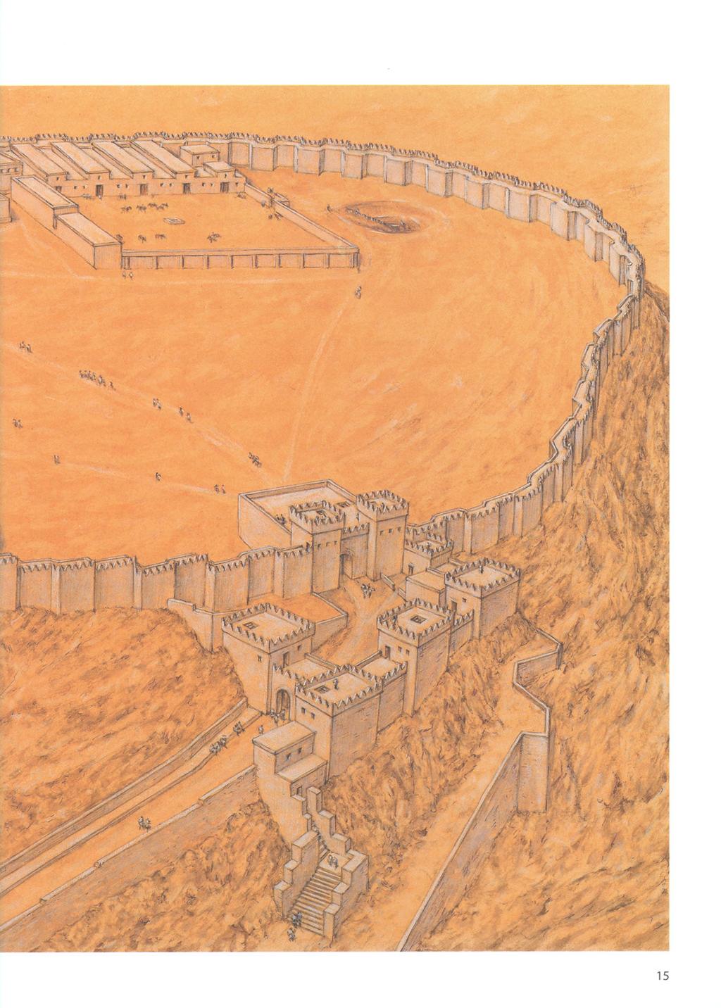
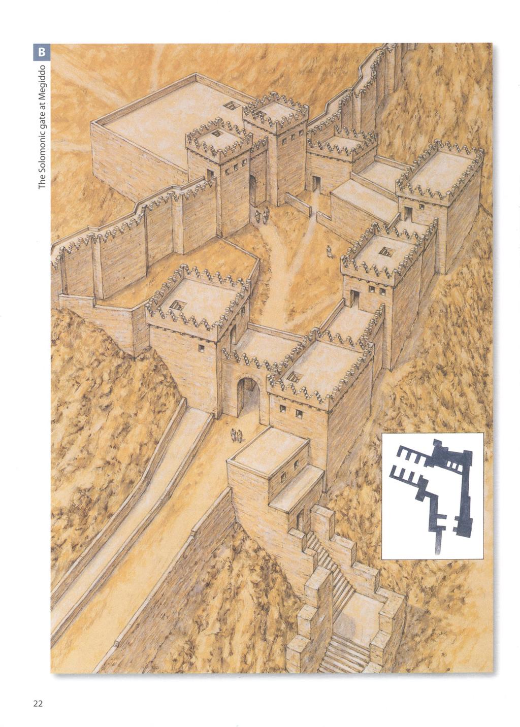
25 battlements on which shields were hung to strengthen the defence. In the early 1960s, Yadin suggested a chronological shift from casemate walls to inset and offset walls caused by the Assyrian adoption of the battering ram. However, it seems more likely that the choice of walls was dictated by the importance of the settlement in the military and administrative hierarchy, as well as by the economic resources available at the time. During the Iron Age II period there is a clear development of the city gate. During the United Monarchy the so-called six-chambered gate was used, whereas the Omrides favoured the smaller four-chambered gate. In Judah, after Sennacherib's destructive campaign, the use of two-chambered gates is attested. The six-chambered gate, excavated at Megiddo VB, Gezer, Lachish III and Hazor, included outer projecting towers, a central passage, which was 4.2m in width, and three square guard chambers on each side of the central passage, and was built of ashlar. At Megiddo VA-IVB, as well as Lachish, the six-chambered gate is preceded by an outer front gate perpendicular to the inner gate, and is connected by a wall to the inner gate. This created a closed space between the two gates that was easily defendable. The four-chambered gate (found at Tel Dan, Megiddo IVA and Beer-sheba II) consisted of a central passage, flanked by two square guard chambers on each side of the central passage. It seems that the reduction from six to four rooms was dictated by the increasingly military character of the city gate. In Biblical Israel, the city gates were the meeting place of the elders, and acted as courthouses (at Megiddo benches were found around the gate). At Megiddo IVB the four-chambered gate still utilized the outer gate, whereas at Dan it was preceded by a simple outer gate which faced the inner gate. The two-chambered gate consisted of a simple central passage, flanked by a square guard chamber on each side of the central passage. This type of gate has been excavated at Lachish II and Tell Beit Mirsim. City walls and gates were the main component of the city defence, but there were other buildings. The king or city governor lived in a palace, similar to the Bit Hilani type of palace, which for the Israelites had an inner courtyard (probably a Canaanite retention), an outer courtyard often surrounded by a wall, and a small gate; it was often built as part of a greater structure. Palaces Megiddo, Stratum IVB. Yadin identified this stratum with the city erected by King Achab of Israel. The settlement was surrounded by a solid inset and offset wall, and featured a four-chambered gate. It included Palace 338, two huge complexes of storage buildings, probably used as stables, grouped in the northern and in the southern part of the city, and a water system. (Dalit Weinblatt-Krausz) jj THE SOLOMONIC GATE AT MEGIDDO The gate was an important military as well as civic element. The monumental six-chambered gate, mentioned in the First Book of Kings, measured 17.8 x 20m in size. Built using ashlar, it stood in the northern part of the site. The gate complex included a frontal gate laid perpendicular to the inner gate, which was connected by a wall to the inner gate. Similar six-chambered gates have been excavated at Megiddo VB, Gezer and Hazor.
26 Omride Samaria. The royal acropolis consisted of a levelled rectangular enclosure, on a characteristic orthogonal plan. The rectangular plan, also seen at Hazor and Jezreel, was characteristic of Omride citadels. (Dalit Weinblatt-Krausz) were generally rectangular, and were entered through a portico, formed by two freestanding pillars, with two more pillars attached to the walls. The pillars were topped by Proto-Aeolic capitals, subdivided into two types: Israelite (Megiddo and Hazor), and Judahite (Jerusalem and Ramat Rahel). Sometimes monumental steps preceded the entrance. A long rectangular-shaped reception room immediately followed the entrance. To the sides and the rear were smaller, square rooms, probably used to store goods or to house guards. A staircase led to an upper floor, which was probably used for dwelling. Sometimes there was a tower at the back of the building. Israelite palaces have been excavated at Megiddo (palaces 1723 and 6000, which probably date to the United Monarchy period, and Palace 338, which dates to the Omrides) and at Lachish III. Smaller palaces in the form of four-room houses were built in less important centres. At Hazor the citadel was rectangular and divided into elongated spaces; however, the central space was divided into two elongated units. The governor's palace at Beer-sheba II was similarly shaped. Administrative buildings have been excavated at Samaria and Hazor, consisting of an elongated courtyard flanked by a wing on each side, divided into various rooms. In the administrative buildings were stored the royal records, often written on papyri. Storage buildings found at Megiddo IVA, Hazor and Beer-sheba II are elongated rectangles in form, and are divided into three parallel aisles. The aisles are divided by two parallel sets of pillars. It seems that the central aisle was slightly higher than the two side aisles, as it was used as a passage. The two side aisles could be used to store goods, but those found at Megiddo IVA have been identified as stables for the war chariot horses. Huge water systems are one of the main characteristics of Israelite fortifications. These held water that often came from a source located outside the city walls. The system often consisted of a vertical shaft, with broad steps leading down to a horizontal tunnel, which in turn led to the water source, often in a cave. The entrance to the cave from outside the citadel was of course 24
27 blocked off. Water systems have been excavated at Megiddo, Hazor and Lachish; the latter, however, was not finished. The water system of Jerusalem will be discussed later. TOUR OF THE SITES The Northern Kingdom of Israel Megiddo The main strata of the Israelite city are Megiddo IVB-VA. According to Yadin, Canaanite Megiddo, (Stratum VIA) was destroyed c.1000 BC. Soon afterwards, during the rule of David, it was rebuilt as an unwalled city with dwellings all along the outer perimeter of the mound (VB). According to Yadin, during the United Monarchy Megiddo was an important administrative centre and the seat of the governor of the Jezreel and Beth Shean valleys. Yadin identified Stratum VA with the period of King Solomon. Solomonic Megiddo was surrounded by a casemate wall. A monumental six-chambered gate, mentioned in the First Book of Kings (9: 15-17) measuring 17.8 x 20m in size, built of ashlar, stood in the northern part of the ovalshaped mound. The gate complex included a frontal gate set laid perpendicular to the inner gate, and connected by a wall to the inner gate. The Solomonic city included two palaces that stood in the southern part of the mound, palaces 6000 and The northern one (6000) was rectangular, while the southern one (1723) had a more complicated plan. ABOVE Lachish, Strata V III. The city fortifications are characterized by an outer and an inner defensive wall. The latter included a six-chambered gate. The city was dominated by a great palace fort, erected on a podium. (Dalit Weinblatt-Krausz) LEFT Beer-sheba, Stratum II. The main characteristic of the site is its radial plan. The city included a four-chambered gate, a casemate wall formed by the outer ring of private dwellings, a public building, the governor's residency and a complex of three-pillared storage buildings. (Dalit Weinblatt-Krausz) 25

28 According to Yadin, the successive stratum IVA dates to the Omride Achab and was destroyed in 732 BC during the Assyrian conquest. At this time the settlement was surrounded by a solid, 3m-wide inset and offset wall. The six-chambered gate was retained for a while, before being replaced by a four-chambered one. Palace 338, built in the eastern part of the mound, served as the residence of high officials. The main characteristic of stratum IVA were the two huge complexes of pillared buildings, probably used as stables. The northern set stood east of the gate, and consisted of two complexes each composed of five units. According to various scholars, the northern buildings could hold 300 horses altogether. The southern complex, consisting of five more units, was built west of Palace 1723, now destroyed. This complex was preceded by a rectangular courtyard. The Megiddo water system consisted of a shaft over 30m deep, cut into the bedrock. It led down to a horizontal tunnel more than 60m long, which led to a natural spring on the edge of the tel. Yadin's stratigraphy has been criticized by Aharoni and Herzog. According to Aharoni, Stratum VB dates to the time of David, and includes only palaces 6000 and The successive stratum IVA included the inset and offset wall, which is the only wall that can be related to the sixchambered gate. Both this wall and the four-chambered gate must date to the reign of Solomon. The Solomonic city also included the two 'stable' complexes. Other archaeologists, such as Finkelstein, date both levels to the Omride dynasty. Hazor The Israelite city developed on top of the Bronze Age Canaanite acropolis. Five strata relate to the Israelite period, Strata IX-V. Solomonic Hazor, dated to Stratum XB, occupied only the western half of the upper mound, an area of approximately 8 acres (3 hectares). The Solomonic city was surrounded by a casemate wall. The entrance was through a six-chambered gate, situated on the eastern part of the citadel. The gate was similar to that of Megiddo, though built of undressed stone. The successive stratum, IXA-B, does not show any deviation from the Solomonic citadel. It seems that Hazor was destroyed during wars with the Arameans in the 9th century BC. The successive Stratum VIII dates to the Omride dynasty, to the time of Achab. The city had doubled in area, now occupying the whole upper mound, and was surrounded by a solid wall. A small fortified palace (Area B) was located on the narrow western spur of the mound. It was separated by a wall from the rest of the city and it was entered by a gate decorated with ashlar pilasters, topped by Proto-Aeolic capitals. The citadel was rectangular in shape and divided into elongated spaces; its central space was divided into two elongated units. Two sets of administrative buildings, consisting of an elongated courtyard flanked by a wing divided into various rooms, stood THE CITADEL OF HAZOR IN THE OMRIDE PERIOD This plate depicts Stratum VIII, dated to the middle of the 8th century BC and the rule of Achab. The city had by now doubled in area, occupying the whole upper mound, and it was surrounded by a solid wall. The earlier Solomonic casemate wall and the sixchambered gate were by then no longer in use. A small fortified palace was located on the narrow western spur of the mound. The city included a storage house as well as a large granary. The water system consisted of a large vertical shaft cut into the solid bedrock below. A characteristic of Hazor was that the walls and gates were built using undressed stone, which was later covered by layers of plaster. The two inset illustrations show an olive press, and the entrance to the shaft of the water system.

29 The citadel of Hazor in the Omride period

30 on each side of the fortified palace. Omride Hazor had a storage building as well as a large granary. The water system consisted of a large vertical shaft cut into the solid bedrock below. Because of its 30m depth, support walls were erected. Broad steps led to the bottom, where a sloping tunnel, 25m long, led into a rock-cut chamber into which groundwater flowed. The successive strata of Israelite Hazor did not greatly change the Omride citadel. Stratum VI, dating to the reign of Jeroboam II, was probably destroyed by earthquake (see Amos 1:1, and Zechariah 14: 5). Stratum VB is dated to the reign of Menachem. In the successive Stratum VA the fortifications were broadened on the eve of Tiglath Pileser Ill's invasion in 732 BC (Second Book of Kings 15: 29). A plan of the six-chambered gate at Megiddo. The gate included outer projecting towers, a central passage and three square guard chambers on each side of the central passage. The gate complex included a frontal monochambered gate set perpendicular to the inner gate, and connected by a wall to the inner gate. (Dalit Weinblatt-Krausz) Samaria The new capital of the Northern Kingdom was founded ex-novo (from scratch) by Omri, and named Shomron. The acropolis of the city was situated on a hill owned by a certain Shemer (First Book of Kings 16: 23-24). Ahab, his successor, completed the construction of the city, which thrived for 150 years, until the Assyrian conquest in 720 BC. The location of the settlement can be linked maybe to Omri's foreign policy; it was situated north-west of Shechem, near an important road running towards the Sharon Plain on the coast, and on another leading northwards through the Jezreel Valley to Phoenicia. Moreover, the city was strategically situated on a steep hill, offering a good view of the surrounding countryside. The excavations were concentrated on the top of the city, where the royal acropolis stood. In fact very little is known of the city itself, which covered an area of several dozen acres. The royal acropolis consisted of a huge, levelled rectangular enclosure, measuring 89 x 178m, which covered an area of 5 acres (2 hectares). The acropolis presents a characteristic orthogonal plan; the top of the hill had to be flattened before the huge royal compound could be built. The earthen fill packed behind the supporting wall was no less than 6m deep in some places. The casemate outer wall, which surrounded the acropolis, was probably designed to relieve the immense pressure of the fill, and the casemate chambers were probably filled with earth. The rectangular plan, common to Hazor and Jezreel as well, is characteristic of Omride citadels. The entrance gate was located on the east side, and was protected by a huge tower. The palace complex displays two main phases of planning and construction. In the first, probably dating to Omri, the main part of the acropolis was paved with a thick lime floor and it was surrounded by a fine 15m ashlar masonry wall, 1.6m thick, built 28
31 using the header and stretcher technique. In the second phase, dating to Achab, the outer wall was replaced on the northern and western sides by a casemate wall. In the north the axis of 54 elongated casemates was perpendicular to the line of the wall. On the south and east sides were 52 smaller rooms. The casemate rooms provided storage space for royal treasures, an arsenal and food stocks. The central palace, rising on the side of the artificial platform, covered an area of approximately half an acre (0.2 hectares). At the centre was a large rectangular courtyard, flanked by several wings. Only the southern one has been preserved. It included rectangular rooms surrounding a central inner courtyard. One of the palace's rooms was filled with ivory, used to inlay palace furniture; the First Book of Kings (22: 39) alludes to the ivory house built by Achab. The Southern Kingdom of Judah Jerusalem Prior to becoming the capital of the Davidic monarchy, Jerusalem was a small Canaanite city (Jebus). Its topography suggested a natural development. The Canaanite city of Jebus was situated on a ridge running north-south, surrounded by the Kidron Valley on the east, and the so-called Tyropoeon Valley on the west. On the north a small hill, Mount Moriah, connected by a ridge running east-west (the Ophel), defended the city. On the east lay two ridges, the northernmost being Mount Scopus, and the southernmost being the Mount of Olives. Thus, the settlement of Jebus lent itself to defence. On the eve of the Israelite conquest, the Jebusite city occupied a surface area of 10 acres (4 hectares), and had a population of 2,000 people. The earlier Israelite settlement bypassed Jebus, and thus at the time of Saul Jebus was still a Canaanite enclave in the territory of the tribe of Benjamin. It is interesting that King Saul erected his fortified residence, Givath Shaul, at Tell El-Full, only a few kilometres from the Jebusite city. The Jebusite city was captured by David (Second Book of Samuel 5: 6-9, and First Book of Chronicles 11: 4-7), and he made it the administrative and religious centre of his kingdom. Although the city was situated in the territory of the tribe of Benjamin, the smallest and least powerful of the tribes, it was near the territory of Judah, the tribe from which David had come; thus it could be said that the capital of the kingdom was situated in an area acceptable to all the tribes, including the two northern tribes of Ephraim and Manasseh. Indeed one of the first acts of David was to transport the Ark of the Covenant to Mount Moriah, north of the city of David. It seems that in this period the city assumed the name of Jerusalem. King David continued to use the earlier Jebusite wall, but erected a palace to serve as the new royal residence and administrative centre of the kingdom on the old acropolis; this was probably located on the Millo, on the north-eastern extremity of the City of David. It was built using a filling of stone and soil, and reinforced by thin stone walls, creating an artificial tel. This was surrounded with a system of terraces to strengthen the tel. This palace may have been erected with the help of King David's ally, the Phoenician King Hiram of Tyre (Second Book of Samuel 5: 11). However, Israelite Jerusalem is mainly connected to King Solomon, the son of David by Bathsheba. Solomon's building projects there, which were probably executed in the first years of his kingdom, are mentioned in the First Book of Kings (6: 1-7, 2, and 7: 13-7, 51) and in the Second Book of Chronicles (4). Solomon built a palace, and his famous temple on Mount Moriah, which came
 to be known as the Temple Mount.")
32 The six-chambered gate at Megiddo. The gate was built using a mixture of ashlar and undressed stone. (Author's photograph, courtesy of Israel Nature and Parks Authority) to be known as the Temple Mount. The Temple was a rectangular-shaped structure, divided into three parts: the Ulam, the Hechal and the Gvir. Two pillars in bronze stood in front of the Temple. Together with the Temple, Solomon erected a palace, described in Kings 7: The palace included various halls, the 'House of the Forest of Lebanon', the 'Hall of Pillars', the 'Hall of the Throne', 'his own House', for dwelling, and 'the other court', and was probably inspired by contemporary Cypro-Phoenician architecture. It seems that Solomon reinforced the city fortifications; a casemate wall was uncovered by Kenyon in the area of the City of David that has been linked to similar Solomonic structures at Megiddo and Hazor. The Warren Shaft - the main well of the city - also dates to this period. This shaft was built on the hill of the City of David, to enable water to be drawn from the Gihon spring during sieges. Jerusalem expanded slightly during King Solomon's reign, reaching an area of 32 acres (13 hectares), and had a population of 5,000. After King Solomon's death, and the end of the United Monarchy, Jerusalem assumed the role of a provincial city. The third period of growth started only with Uzziah's reign in the 8th century BC. According to the Second Book of Chronicles (26: 9) he reinforced the walls of Jerusalem and built the towers. Jotham continued to fortify the city. However, the situation changed dramatically after the fall of Samaria to the Assyrians in 722 BC. Many Israelites, fleeing the Assyrians, settled in Jerusalem. By the time of Hezekiah, Jerusalem covered an area of 25 acres (10 hectares), and had a population of no fewer than 25,000 souls. 30

33 Hezekiah erected a new wall that encompassed the new quarters west of the City of David in preparation for a possible military confrontation with the Assyrians. This new wall began on the west side of the Temple Mount, and continued westwards all along the Transversal Valley, to the northern slopes of Mount Zion. From there it turned southwards all along the western slopes of Mount Zion down to the Valley of Hinnom in the south, then it turned eastwards, joining the City of David in its southern part. The northern section of this huge wall was excavated in the Jewish Quarter of Jerusalem. The section is 65m long, and is no less than 3.5m thick. Two towers were discovered on the line of the wall, probably pointing to the existence of a gate. Under the 'broad wall' were found remains of private dwellings. The most ambitious defensive preparations comprised the erection of various structures, the task of which was to bring water to the besieged population. Hezekiah enlarged the city wall to include the Siloam Pool, and then constructed the horizontal Hezekiah Tunnel, which connected the Gihon Spring (outside the walls) to the Siloam Pool (Second Book of Kings 20:20 and Second Book of Chronicles 32:30), an event recorded in the Siloam Inscription in the Istanbul Museum of Archaeology. Hezekiah also erected a dam across the Beth Zetha Valley to catch the floodwaters there. In addition, the northernmost of the two Bethesda Pools was excavated; an opening was made in the dam to drain off water to a conduit. Hezekiah's Jerusalem valiantly withstood the Assyrian Siege of 701 BC. Indeed, the fortifications built by Hezekiah would endure until the sieges of Nebuchadnezzar in 597 and 587 BC. 0 15m A plan of the six-chambered gate at Hazor. The gate was similar to that at Megiddo, though built of undressed stone. (Dalit Weinblatt-Krausz) mm * - p The six-chambered gate at Hazor. This photograph clearly shows the two parallel sets of three chambers. (Author's photograph, courtesy of Israel Nature and Parks Authority) 31

34 Kuntillet Ajrud This unique site along the 'Gaza Road', is located about 50km south of Kadesh Barnea. An isolated building was erected on the top of a steep hill, near a crossroad leading into the Sinai Desert and close to water wells. The building was rectangular in shape, measuring 15 x 25m, and consisted of a large central courtyard surrounded on three sides by long casemate rooms with projecting corner towers. The entrance was through a gate chamber which created a 'bent axis' approach into a broad room. In both rooms benches were constructed along the walls, and white plaster covered the walls, floors and benches. Among various finds were objects made of organic materials, such as basketry, ropes and textiles. The lack of Negbite handmade pottery here shows that there was no relationship with the local nomads. The pottery that was found indicates a date between the mid 9th century and mid 8th century BC. The combination of Israelite and Judahite elements may reflect a period when the Northern Kingdom's sphere of influence extended to Judah, as during the reign of Queen Athaliah. A plan of the six-chambered gate at Gezer. (Dalit Weinblatt- Krausz) Lack isb The mound on which Lachish stands (Tell el-duweir) is located in an area in the Lower Shephelah, near the main road leading to the southern coastal plain, and occupies a surface area of 20 acres (8 hectares). During the United Monarchy, Lachish, Stratum V, was only partly rebuilt, and remained unfortified. The erection of the huge city and its fortifications, Stratum IV, can be dated to King Rehoboam (Second Book of Chronicles 11: 9). Stratum III, when the city reached its peak, was destroyed during Sennacherib's siege and conquest in 701 BC. During the reign of Manasseh the city was rebuilt (Stratum II). The city was finally destroyed in 587 BC. Lachish was the administrative and military headquarters of Judahite government in southern Shephelah. The city fortifications are characterized by an outer and an inner defensive wall. The outer wall was erected on the middle of the mount's slope, while the inner wall was erected at the summit. The inner wall was 6m thick, and had a stone foundation topped by bricks. The city gate complex includes an access ramp along the slope of the mound, and an outer and inner gate. The outer gate was protected by a huge bastion erected on the slope of the wall. A small piazza inside the outer wall led to a six-chambered gate. This must be early in date, and was possibly erected not many years after Solomon. However, according to Ussishkin, who excavated the city, the city fortifications were mostly erected by either Asa or Jehoshaphat. The fortifications of Stratum II were less solid, and the gate complex was much weaker. The inner and outer gates were both of the two-chamber type. The whole northern part of the city was allocated to a royal government. It was separated from the city by a huge, thick wall. Its main structure was a great palace fort, erected on a podium. The first phase of the building consisted of a square structure, which measured 32 x 32m; its date is unclear, being erected either in Stratum V, during the United Monarchy, or in the following Stratum IV. During the next phase, the building was enlarged to the south by 44m. During the last phase, the palace was enlarged to the east, resulting in the final structure of a huge building measuring 36 x 76m. It remains the largest Iron Age structure excavated in Israel. The podium elevated the building 6m above the surrounding land. The plan of the palace itself is unclear. East of the palace stood a spacious, paved courtyard surrounded by a defensive wall and entered via a six-chambered gate structure. Elongated rectangular buildings on the side of the courtyard served as storerooms, or perhaps stables. 0 15m The Negev The United Monarchy fortified enclosures Rapid and widespread settlement occurred in the Central Negev Highlands during the United Monarchy. Various enclosures, excavated in the area, date from this period. The Central Negev Highlands are bordered on the east by the cliffs of Nahal Zin, on the south by the depression of Machtesh Rammon, on the west by the oasis of Kadesh Barnea and on the east by the Sinai Desert. About 50 fortified enclosures, often referred to as fortresses, have been surveyed and excavated. Often these were erected near water sources or wadi beds. Most of the fortresses were situated on hills within sight of each other. The widespread distribution points to a general settlement in the region, and not control of any specific area. Most of these fortresses were 25-70m in diameter; their shape could be circular, oval, triangular or amorphic, following the 32
35 contour of the hill. Usually they include a row of casemate walls with rooms and a large central courtyard, the latter accessed through a narrow entrance. The main examples are 'En Kadesh, Atar Haro'e, Hurvath Haluqim, Hurvat Rahba, Hurvat Ketef Shifta and Ramat Matred. Groups of dwellings have been excavated near these fortresses. The sites were only briefly inhabited. Two groups of pottery were found. The first consists of wheelshaped pottery identical to that found in other sites dated to the period of the United Monarchy in Judah. The second consists of handmade pottery called Negbite ware, which was made by local nomads. According to B. Rottemberg, D. Eitam and I. Finkelstein, these fortified enclosures were made by Amalecites, or Israelites of the Tribe of Simeon, and later destroyed by Saul. Finkelstein stresses the similarity between these structures and modern Bedouin pens. However, various scholars contest this earlier dating. If these settlements were erected by Amalecites, it is unclear why Israelite pottery was found in situ. Aharoni suggested a gradual Israelite penetration of the Negev Highlands. He therefore dates these fortresses to Iron Age I, the 11th century BC, contemporary to the Israelite settlement of Tel Masos. However, Glueck, Meshel and Cohen V i view these sites as the result of a royal initiative. As the Israelites established farms in the Negev Highlands, administrative centres were built to host royal officials and landowners. According to Meshel, these fortresses were established during the reign of Saul to protect against desert nomads, such as the Amalecites. Cohen dates these fortresses to the reign of Solomon. These settlements were destroyed as a result of a Shishaq military campaign in the region. In fact Shishaq's list on the walls of the Temple at Karnak includes no fewer than 70 place-names from the Negev. Palace 1723 at Megiddo. This building was preceded by a rectangular courtyard that was entered through a four-chambered gate. (Dalit Weinblatt-Krausz) The judahite fortresses of the Negev The Judahite defence of the Negev was concentrated in two main areas, the Northern Negev and the Central and Southern Negev. The area reached its main phase of development only in the 7th century BC. The main tasks of these fortresses were the control of the trade road descending towards the Dead Sea and Transjordan, to defend against the Edomite raids and to protect the local nomadic population. Various finds from the Northern Negev point to its role in international trade during this period. The prosperity of the region must have been related to Assyrian economic and political interests, which furthered trade connections between Edom, Judah and the coast through the Negev. This economic activity continued even after the fall of Assyria. The finds include pottery from Edom and Philistia, and Assyrian imported artefacts. Slowly the area passed from Judahite to Edomite control. The main Edomite site excavated in the region is Hurvat Qitmit. 33

36 Beer-sheba in the Northern Negev

37 The main fortresses in the Northern Negev, Beer-sheba and Arad, are dealt with below; other fortresses were at Hurvat Uza, Tel Ira, Aroer, Tel Masos and Tel Malhata. After the 10th century BC, the Central and Southern Negev areas remained unsettled until the end of the Iron Age. Only three Iron Age II settlements are known south of Beer-sheba: Kadesh Barnea, Kuntillet Ajrud and Tell el-kheleifeh. All these settlements indicate a major Judahite effort to control the approach to the Red Sea along the Gaza Road during the 8th and 7th centuries BC. Trade relations with Arabia through the Red Sea continued as part of international trade between Edom, Judah, Israel and the Phoenicians, under Assyrian guidance. In the 7th century Edom took possession of the sites in the Northern Negev. Palace 6000 at Megiddo, similar to the Syrian Bit Hilani style of palace, was a rectangular structure. It was entered through a monumental 'distylos in antis' (i.e. with two columns in front), which was immediately followed by the reception hall in the centre of the building. (Dalit Weinblatt-Krausz) Tel Beer-sheba During the 9th and 8th centuries BC the small town of Tel Beer-sheba in the Northern Negev was the main Judahite centre in the region. It was well planned and it underwent several stages of development. The entire area covered approximately 11,500m. The initial Stratum IV, dated to the 10th-9th century 2 BC, was a fortified town surrounded by a solid wall and a massive earth rampart, entered through a gate. In Stratum III II, the solid wall was replaced by a casemate wall, and the gate was rebuilt as a four-chambered gate, located on the south-east side of the town. The main characteristic of the town was its radial plan. Three main streets shape the city. The first consists of a circular, outer, peripheral street parallel to the city wall, that was separated from it by BEER-SHEBA IN THE NORTHERN NEGEV Tel Sheba in the Northern Negev has been identified with the Biblical Beer-sheba. The latter was the most important citadel in the area. The site covered an area of approximately 11,500m 2. The city of Strata lll-ll was defended by a casemate wall, and it had a four-chambered gate. The main characteristic of the town is its radial plan. The governor's palace was located near the city gate. A complex of threepillared buildings, probably used to store food, was erected adjacent to the city gate. At the north-eastern corner of the site stood a water shaft.

38 a row of buildings. The second consists of an inner peripheral street, which was parallel to the outer one. In addition, the settlement is divided in the middle by a street leading from the city gate. The outer street was separated from the casemate wall by a line of houses integrated into the wall itself. The casemate wall consisted of the outer wall of the four-roomed houses. The governor's palace identified by Aharoni, the excavator, was located near the city gate. It was built on undressed stone foundations, using ashlar and mud bricks. It was more or less a two-storey squared building, which measured 10 x 18m. Small rooms on the western and southern sides served as living quarters and service rooms. It seems that the ceremonial area was located in the long halls on the eastern side of the second storey. A complex of three-pillared buildings was erected adjacent to the city gate, and the facade of each faced the street. It seems that these buildings were used to store food. These storage buildings indicate that town was the main administrative centre in the Northern Negev. At the north-eastern corner of the mound stood a shaft, with a flight of stairs built into the supporting wall; the shaft has not been excavated. Tel Beer-sheba was destroyed towards the end of the 8th century or in the early 7th century BC, during or after Hezekiah's time. Tel Arad During the Iron Age I period a small village already stood on the top of the tel at Arad (Stratum XII) in the Northern Negev. This was replaced by a royal fortress around the 10th century BC. The fortress served as an important administrative and military stronghold of the Kingdom of Judah in the region, guarding the road from the Judaean Hills to the Aravah, and to Moab and Edom. The fortress developed until the end of the Iron Age (Strata XI-VI). The earliest fortress (Stratum XI) was a square structure, around 50 x 50m in size, located on a high hill, which dominated the surrounding area. The fortress was surrounded by a casemate wall. This phase has been dated to Solomon's reign, through a later date, the 9th century BC, can be accepted. The next stratum, Stratum X, is dated to Uzziah's reign. The fortress was now provided with solid stone walls of inset and offset pattern. An entrance gate flanked by two towers stood in the middle of the eastern wall. A central courtyard was flanked by storage rooms, dwelling rooms and a temple located in its north-western corner. The water supply came from a deep, stone-lined well in the valley at the foot of the hill, from where it was brought by donkeys to a canal that passed through the outside wall of the fortress and into the rock-cut cisterns. According to Aharoni, the fortress continued to develop in Strata IX-VIII. The severe destruction exhibited in Stratum VIII is attributed to the Edomites, who in the wake of Sennacherib's campaign in 701 BC, which drained the resources of the Kingdom of Judah, invaded the area and burned down the fortress. The fortress of Strata VII-VI, which followed the same layout, is dated to the 7th century BC. At the end of the 7th century BC
 Tel el-kheleifeh the fortress was rebuilt, with an outer casemate wall (Stratum VI). The date suggested by Aharoni is not accepted by every scholar.")
39 The palace fort at Lachish, Stratum III, which was erected on a podium. This is the largest Iron Age structure excavated in Israel to date. (Dalit Weinblatt-Krausz) Tel el-kheleifeh the fortress was rebuilt, with an outer casemate wall (Stratum VI). The date suggested by Aharoni is not accepted by every scholar. According to Yadin and Dunayevsky, the fortress with inset and offset walls continued in use until the end of the Israelite period, and the successive fortress with casemate walls must be dated to the Hellenistic period. Kadesh Barnea Kadesh Barnea was the most important oasis on the border between the Sinai and the Negev. During the 10th century BC an elliptical casemate enclosure was built on the mound of the oasis. It was the westernmost of a cluster of some 50 fortresses of the 10th century BC in the Central Negev highlands. Like all other fortresses in the group this site was destroyed towards the end of the 10th century BC during Shishaq's campaign. However, although all the other sites were abandoned after their destruction, Kadesh Barnea continued to be an important Judahite stronghold in the following centuries, though perhaps after a gap of 100 years. The new fortress became the main Judahite base along the Gaza Road. This stronghold was also essential in controlling the nomadic population of the Negev and eastern Sinai. This site, not far from Eilath, was located at the ends of routes leading to the Red Sea. Excavated in the 1940s by Glueck, it has been identified with the Biblical Etzion Geber. According to the First Book of Kings (9:26-28; 10:1-13), it was established by Solomon as a base for trade in the Red Sea area. It seems that the site was established to further naval and mercantile activity by the United Monarchy, and later on by the Kingdom of Judah, in the Red Sea. The first fortress (Period I) consists of an open courtyard, measuring 45 x 45m, surrounded by a casemate wall. Inside the courtyard stood a single building planned as a fourroom house. Later (Period II), the enclosure was enlarged to 60 x 60m. It was entered through a four-chambered gate and it was defended by a solid outer wall with inset and offset sections. The Period III fortification was similar in its layout to Arad, although smaller. During Period III, various structures were built inside the fortress courtyard. This well-planned fort had a military and administrative nature. It is possible that the Judahite stronghold of Etzion Geber in the 7th century BC passed into Edomite hands. Another possibility is that the fortress was an Edomite stronghold never related to the Israelites, but the presence of Judahite and Negbite pottery, which attests to the presence of local nomads, suggests this to be incorrect. 37
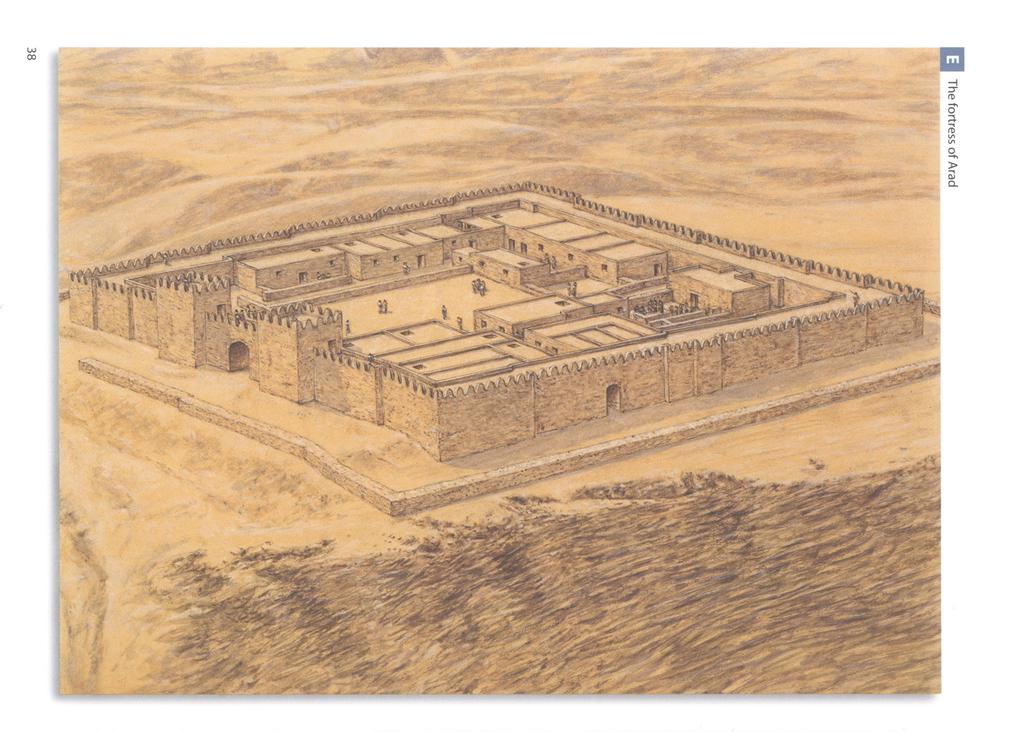
40

41 The fortress of Kadesh Barnea was a rectangular structure measuring 40 x 60m, enclosed by a 4m-wide solid wall with eight rectangular towers. Four of the towers stood on the corners, while the other four stood in the middle of each encircling wall. The wall was surrounded by an impressive earth rampart supported by an outer retaining wall. The gate has not been found. Perhaps entry was gained by way of a ramp on top of the earth rampart. A built-up water reservoir inside the citadel was filled from a canal bringing water from the oasis spring. This fortress was erected probably in the early 8th century BC during Uzziah's reign (Second Book of Chronicles 26: 10). It was destroyed in the early 7th century BC, either by Nomads or by Edomites in the years after Sennacherib's invasion and Manasseh's reign. The fortress was rebuilt in the same shape, but this time the solid wall was exchanged for a casemate wall, which was the same width as the original. The fortress was destroyed in 587 BC. The presence of so-called Negbite handmade pottery, side by side with Judahite wheel-made pottery, indicates the presence of a semi-nomadic local population, who may have lived together with the garrison, and probably benefited from royal resources. The Judaean Desert, the Judaean Hills and Shephelah The other main areas in which fortifications were erected in the Kingdom of Judah were the Judaean Desert, the Judaean Hills and Shephelah. In the Judaean Desert the main fortification excavated is located at Vered Jericho, not far from Jericho. This unique type of fortress guarded the road from Jericho to the Dead Sea. The fortress consists of a rectangular building, the entrance of which is defended by two flanking towers. Inside, the rectangular courtyard leads to two parallel and attached 'four-room house' units. The regular planning and defensive character indicate that the function of the building was official. Several fortress and towers have been discovered in the Judaean Hills and Shephelah. The fortresses were square or rectangular in shape and had a large central courtyard surrounded by casemate walls with rooms on the outer wall. The two main fortifications discovered are located at Khirbet Abu et-twein and Hurvat Eres. The former is located on the western slopes of the Hebron Hills. It stands on a high hill, with an excellent view of the Shephelah and the Valley of Elah. The building measures 30 x 30m in size. It had a chamber gate and a central courtyard surrounded by a double row of rooms. These two rows were separated by rows of monolithic pillars to which partition walls were attached. Khirbet Abu et-twein formed part of a network of strongholds in the hilly and probably forested region which separated the Hebron Mountain ridge from the inner Shephelah. The fortress of Hurvat Eres was located on a high ridge west of Jerusalem offering a view of the coastal plain as well of the Jerusalem area. The location of the Judaean stronghold suggests that one of the main functions was to ease communications by fire signals between different parts of the Kingdom of THE FORTRESS OF ARAD Arad was a small fort located in the south-eastern Negev. The fortress was located on a high hill, which dominated the whole surrounding area. Stratum X is dated to the reign of Uzziah. The fortress was protected by a stone wall comprising inset and offset sections. An entrance gate flanked by two towers stood in the middle of the eastern wall. The central courtyard was flanked by storage rooms, dwellings, and a temple located in its north-western corner.

42 Judah. The use of these communications is known from Jeremiah (6: 1) and the Lachish letters. Moreover, around Jerusalem there were also freestanding, elevated, isolated, solid towers, usually built on podiums. Two of these are known. One is situated on a high ridge north of the city in the modern neighbourhood of French Hill, and the other on a ridge south of the city in the quarter of Giloh. THE LIVING SITES o 5 m A plan of the governor's palace at Beer-sheba. This square, two-storey-high building was located near the city gate. The ceremonial area was located in the long hall on the eastern side of the second storey. (Dalit Weinblatt-Krausz) Most of the data that we have on the Israelite army comes from the Bible, and refers mainly to the army of the United Monarchy. Thus, according to Yadin, the Israelite army was made up of two separate formations: the regular army and the militia. The regular army consisted of two separate bodies, the Israelites and foreign mercenaries. The Israelite standing army probably originated in the people who gathered around David in the cave at Adullam, when the latter was fleeing from the jealousy of Saul. They consisted of around 400 men (First Book of Samuel 22: 1-2). Later, the number rose to approximately 600 men. Once David became king of all Israel, this group, often referred to as 'David's heroes', formed the nucleus of the regular army (First Book of Samuel 30). Together with the king and the army commander, Joab Ben Serujah, a small part of this group known as 'the Thirty' were organized into a supreme army council. This body decided on promotions and appointments, framed army regulations and selected the permanent commanders of the militia army. David's mercenary force consisted of the Cherethites, Pelethites, and Gathites (Second Book of Samuel 15: 17-21). The organization of the militia during the United Monarchy is described in the First Book of Chronicles (27: 1-15). According to Yadin, the A plan of the administrative buildings west of the palace of Samaria. These three buildings featured an elongated central courtyard flanked on each side by wings that were divided on each side into three rooms. (Dalit Weinblatt-Krausz) 40

43 text in Chronicles clearly indicates that by then the army was no longer organized on the basis of tribal levies, but rather its organization depended on a strong central administration. The organic division into 12 formations shows that the militia was organized in advance of any conflict, with permanent units of equal size. Moreover, the same quota was imposed on every region. The militia was called up according to the units and not according to individuals. It is probable that in times of emergency all units would be engaged. At the head of each of the 12 formations stood a leading commander, or 'Commander of the Host'. Each formation consisted of 24,000 warriors, and was itself subdivided into units of thousands, each of which were divided into smaller units of hundreds. Last but not least, there was a system of rotation, with each formation serving for a month a year. It is probable that the kingdoms of Israel and Judah retained the same structure for their respective armies. The only data that we have on the army of the Kingdom of Israel in its full strength, which comes from Assyrian documents, is that concerning the battle of Kurkar, when Achab fielded 500 chariots and 10,000 infantrymen. The sole information on the army of Judah comes from the Second Book of Chronicles and relates to the reigns of Jehoshaphat and Uzziah. The first passage (17: 12-19) relates to the reign of Jehoshaphat. The tribe of Judah was divided into three military districts, while the tribe of Benjamin was divided into two of them, depending on the royal administration. The second passage (26: 11-13) relates to the status of the army during Uzziah's reign. The Judahite army now demonstrated the strong influence of the royal administration. Two officials, Jehiel, a scribe who kept the accounts, and the officer Ma'aseiah, were responsible for its organization. The various weapons, listed as 'shields, and spears, and helmets, and body armour, and bows, and stones for slinging', were kept in royal storehouses distributed around the fortresses of the kingdom. The field army was commanded by 'Hananiah, one of the king's commanders'. The Judahite army in this period was organized into units. The nucleus of the army consisted of 2,600 men, and when expanded the army numbered no fewer than 307,500 men. The latter number is probably grossly inflated, but it shows that the system of a small regular army working alongside a militia called up in times of emergency was maintained. Moreover, in the last years of the kingdom, probably from the reign of Josiah onwards, if not before, Greek mercenaries from Ionia served the kingdom as well. The armies of the United Monarchy, as well as those of the kingdoms of Israel and Judah, were made up of chariots, cavalry and infantry. According to the Bible (First Book of Kings 10: 26 and Second Book of Chronicles 9: 25), King Solomon possessed a strong chariot force. Yadin calculates the number of chariots as being between 500 and 1,400, stressing that the first number is probably closer to the truth. However, Achab at Kurkar had no fewer than 500 chariots. After the conquest of Samaria, Sargon organized a separate unit A plan of Building 71a, Area A at Hazor. This building takes the form of an elongated rectangle, divided into three parallel aisles delineated by two parallel sets of pillars. The central aisle was used as a passage, while the two side aisles were used to store goods. (Dalit Weinblatt-Krausz) 41
 in the Assyrian army that numbered 50 chariots, the remains of the chariot unit of the Kingdom of Israel.")
44 The remains of Building 71 a, Area A at Hazor. (Author's photograph, courtesy of Israel Nature and Parks Authority) in the Assyrian army that numbered 50 chariots, the remains of the chariot unit of the Kingdom of Israel. It seems that the Kingdom of Judah possessed a much smaller chariot force than the Kingdom of Israel. The cavalry were divided into heavy cavalry armed with spears, and light cavalry armed with bows. The infantry were probably divided into three broad units: spearmen, archers and sling men. Spearmen, the heavy infantry, made up the bulk of the army; each was protected by a helmet, a cuirass, and a shield, and was armed with a sword and a spear. Archers and sling men were used as light infantry. Although the army of the northern Kingdom of Israel, in which the chariots played such an important part, had an offensive character, the A manger set between two pillars, in the Northern Stables complex at Megiddo. (Author's photograph, courtesy of Israel Nature and Parks Authority) 42

45 fortifications were still very important. In the Omride period, although Megiddo was rebuilt with complexes of stables for the chariots, the other fortifications of Dan, Hazor, Jezreel and the royal acropolis of Samaria stood as the main defensive strongholds of the kingdom. In contrast to the Kingdom of Israel, the army of Judah was much more closely linked to the kingdom's fortifications. Here the static defence was based on a chain of previously discussed regional fortresses. The Bible stresses the importance of the various A pillared building in the Southern Stables complex at Megiddo. (Author's photograph, courtesy of Israel Nature and Parks Authority) The silos at Megiddo. (Author's photograph, courtesy of Israel Nature and Parks Authority) 43
46 fortifications erected by Judah's rulers. According to the Second Book of Chronicles (11: 5-12), Rehoboam fortified the cities of Beth-Lehem, Etam, Tekoa, Beth-Zur, Socoh, Adullam, Gath, Mareshah, Ziph, Adoraim, Lachish, Azekah, Zorah, Aijalon and Hebron. Jehoshaphat (17: 1, 12) fortified the cities in the tribal area of Ephraim, taken from the Kingdom of Israel by his father Asa. He also built castles and store-cities in Judah, including in Jerusalem. King Uzziah (26: 9-10) fortified Jerusalem, and erected various 'tower' fortifications in the Shephelah and in the Negev. It is important to understand that the various fortifications erected in Israel and Judah did not have a solely military purpose. Most of the fortifications were primarily important as administrative centres. Thus, the royal official ('Sar hair') who resided in and commanded the fortification was in fact a civilian. His main task in peacetime was to levy taxes from the area around the fortress, the administration of which he was responsible for. These taxes were often grain (wheat and barley), oil and wine. Part of the products collected was not sent to the capital, but was stored in the city storage houses in case of emergency. Although the Sar hair had under his command the units of the standing army, which garrisoned the place, these had their own officers. It seems that most of the population, with the exception of those in the big cities such as Samaria in Israel and Jerusalem in Judah, did not live inside the city walls, but dwelt outside in houses scattered all around the countryside. However, the various officials, who assisted the Sar hair - such as the scribes who kept the archives or the people responsible for managing the store houses, or various artisans - certainly did live inside the city. In time of war Everything changed during times of war. First of all, the Sar hair had to call on the militia. The various local levies were organized into a military force. The militia could reinforce the local regular garrison, or they could be sent elsewhere to defend an area or a place that was under more immediate threat from the enemy. In Judah, fire signals were used to announce that the enemy was approaching, giving time to prepare the city or the fort for a siege. Many logistical preparations had to be made. The local population, living in the surrounding area, naturally came into the site to escape the enemy army. The store houses had to be brought to maximum capacity, as the Sar hair had to feed not just his officials, the army, the standing forces and the militia, but the whole incoming population as well. Space available was limited, and the resulting congestion could result in poor health and epidemics. The problem of feeding the civilians weighed heavily on the Sar hair, and if there was insufficient food and water then famine would certainly follow. Next, the city fortifications were strengthened. Wooden battlements were erected on top of the walls and towers, and shields were hung from these to afford the maximum protection. The water system was also reinforced. The fortification was now ready to be tested by siege. The ostraca (shards of stone or pottery bearing inscriptions) from Arad and from Lachish help us to understand how a city or a fort functioned in peacetime and how it prepared for siege. Those from Arad were found in various strata. A letter, dated to Hezekiah's reign, was sent to the military commander of the fortress, whose name was Malkiyahu, and mentions conflict with Edom. However, most of the ostraca belong to the archives of a certain Elyashib, who commanded the fortress in a later period. These ostraca comprise the correspondence between Elyashib and other commanders in the upper military
47 hierarchy. Seven of these letters were sent from Jerusalem. They include a fragmentary one from one of the last kings of Judah, perhaps Jehoahaz, who announces his enthronement, and discusses matters of international policy, mentioning the ruler of Egypt. Another ostracon orders the dispatching of troops from a place called Qinah to Ramoth Negev, which may be the fortress of Hurvath Uza, as an emergency measure to withstand the Edomite threat. However, most of the correspondence deals with logistical and not with strategic problems. Arad appears on the ostraca as a receiver and distributor of food supplies. Flour, oil and wine were sent from towns in the southern Hebron Hills, perhaps as royal taxes, and in turn were allocated by Arad to other forts and troops located in the Negev. Several other ostraca are letters of introduction to the commander of Arad from officials elsewhere in Judah, requesting that food supplies be assigned to a certain messenger. Other letters include instructions to send supplies to the Kittim, who were probably Greek mercenaries, serving in the Judahite army. The name probably originated in the city of Kition, in Cyprus. The discovery of Cypriot and Eastern Greek pottery in the Northern Negev enhances this possibility. The ostraca from Lachish are dated to Stratum II, slightly before the Babylonian destruction of the city during the last days of Judah. They consist of correspondence found in the burned debris of the city gate, which were written by a certain Hoshayahu to his commander Yaush. According to N.H. Tur-Sinai, Hoshayahu was the commander of a small fortress outside Lachish, while Yaush was the commander of Lachish. However, according to Yadin, these ostraca were drafts of correspondence sent from Lachish to Jerusalem. Accordingly, Hoshayahu would be the commander of Lachish, and Yaush a high official in the capital. One of the letters has a dramatic end: 'And may my lord know that we are watching for the beacons of Lachish, according to all the signs which my lord has given, for we cannot see [the signals] of Azekah.' Until the advent of the Assyrians, the main device used during siege warfare was the scaling ladder. The early Israelite fortifications, designed to withstand sieges by the neighboring Arameans, Moabites, Ammonites and Edomites, thus relied on casemate walls for their defence. These provided for the concentration of troops and storage, enough to defend the city. The besieged knew that time was on their side. Thus, if they had sufficient provisions to face a long siege, by harvest time the enemy army would be obliged to abandon the siege and return to their fields. A cross section of the Megiddo water system. The system consisted of a vertical shaft, with broad steps leading down to its bottom. From there a horizontal tunnel led to the water source, which lay outside the city walls. (Dalit Weinblatt-Krausz) 45

48 Lachish: preparing for the Assyrian siege

49 However, with the Assyrians siege warfare changed completely. The Assyrians were not only much more methodical in organizing sieges, but they also had new siege weapons, such as the battering ram. The defenders in Israel and Judah thus reacted by building stronger walls featuring inset and offset sections and fortified with towers. Once they had surrounded the city or fortification, the Assyrians erected a camp. Their army would then search for a weak spot in the walls, more often than not near the city gate. There they would construct an earth rampart, the purpose of which was to bring battering rams close to the city wall. This siege machine was rectangular in shape, and mounted on four wheels, and was topped by a wooden frame covered with animal skins. The front of the battering ram was topped with a tower, from where archers could fire incendiary arrows. The skins were kept wet so that the defenders could not set fire to the engine. The ram had a metal point on the end, and was used to batter a hole in the wall - which did not take long, given that the walls were more often than not made of mud-brick. Although the Assyrian army preferred to take the city by storm rather than wait for its surrender, psychological warfare was used, to reduce the costs of time and human life for the attackers. ABOVE The shaft of the Megiddo water system. (Author's photograph, courtesy of Israel Nature and Parks Authority) LEFT The tunnel in the Megiddo Water System. (Author's photograph, courtesy of Israel Nature and Parks Authority) IJH LACHISH: PREPARING FOR THE ASSYRIAN SIEGE After Jerusalem, Lachish was the most important city in the defensive wall. The city gate complex includes an access Kingdom of Judah. This illustration shows Stratum III, on the ramp alongside the slope of the mound, and an outer and eve of the Assyrian siege, after the defenders had erected inner six-chambered gate. The whole northern part of the the battlements and emplaced their shields as a means city was separated off by a huge wall. The main structure of further defence. The city occupied an area of 20 acres comprised a palace fort, erected on a podium, in which (8 hectares). The city fortifications had an outer and an inner resided the royal governor.
50 Any captured enemy troops were executed, having previously been subjected to various forms of torture. The watching city population would hopefully be terrorized into submission. With the exception of Jerusalem, which later fell to the Babylonians using the same siege methods as the Assyrians, the cities of Israel and Judah fell one after the other to the Assyrian besiegers. After the city had been stormed, the Assyrians publicly executed the city officials and the military commanders who had refused to surrender. Then the Assyrians collected the remnants of the population to deport them to a far-off place. Often another population was settled in the ruined city instead. The Babylonians followed similar methods, but they preferred to deport only the ruling class. The Book of Lamentations describes in detail the fate of Jerusalem after the Babylonian conquest, and the terrible effects of the famine inside the city, as well as the fury of the enemy: The tongue of the sucking child cleaves to the roof of his mouth for thirst; the young children ask for bread, and none break it unto them... They that did feed on dainties are desolate in the streets; they that were brought up in scarlet embrace dunghills... Her princes were purer than snow, they were whiter than milk, they were ruddier in body than rubies, their polishing was as of sapphire... now their visage is blacker than coal; they are not known in the streets; their skin is shrivelled upon their bones; it is withered, it is become like a stick... They that are slain with the sword are better than they that are slain with hunger; for these pine away, stricken through, for want of the fruits of the field... (Book of Lamentations 4: 4-10) THE SITES AT WAR Sennacherib's campaign in Judah, 701 BC For Sennacherib's campaign against Judah in 701 BC we are fortunate enough to have several separate sources. The first is Sennacherib's Prism (or the Taylor Prism), a cuneiform document that contains the annals of Sennacherib, and the second is the Bible, which records King Hezekiah's war against Sennacherib in the Second Book of Kings (18: 7-36 and 19: 1-37), the Prophet Isaiah (36: 1-22 and 37: 1-38) and the Second Book of Chronicles (32: 1-23). The archaeological discoveries at Jerusalem and Lachish help to complete the picture. In 715 BC, after the death of Ahaz, Hezekiah succeeded to the throne of Judah. He began a series of religious reforms, as well as an aggressive foreign policy. At the beginning his main successes were against the Philistines in the south-eastern Shephelah and on the coast. He annexed to his kingdom the area surrounding Gerar, once part of the Judahite kingdom, forced Gaza to submit, and conquered the area around Joppa. This last step gave Judah a foothold on the Mediterranean coast. However, Hezekiah scored notable diplomatic successes as a consequence of his successful campaigns. Padi, king of Ekron, abdicated; a ruler more acceptable to Hezekiah was chosen in his place. The Philistine city of Ashkelon entered into a defensive alliance with the Judahite ruler. Soon after, Luli, king of the Phoenician city of Tyre, followed suit. Moreover, it seems that Hezekiah found another ally in Tirhakah, the Kushite leader of Egypt, and in Marduk-apla-iddina II, who had seized the throne of Babylon. Thus in a short time, the Judahite king, through successful military campaigns and diplomacy, succeeded in creating
51 a series of buffer states around Judah. Hezekiah well knew that his small army could not face the Assyrian army in the open field, and so he reinforced the defences of his kingdom, notably the cities of Jerusalem and Lachish, as well as various small forts. Judah was now ready to face Assyria. The casus belli came when Hezekiah refused to pay to Sennacherib annual tribute. Thus in 701 BC the Assyrian army moved against Judah and its allies. Sennacherib's hexagonal clay prism was discovered among the ruins of Nineveh. The prism, created around 689 BC, is in the Akkadian language. After a short introduction, exalting his qualities, Sennacherib describes the various campaigns waged by the Assyrian army under his command. His main account is the campaign against Hezekiah in 701 BC, which was waged first against Hezekiah's allies, who submitted one after the other, and then against Judah, now alone in facing the Assyrian king's wrath. Sennacherib first targeted the Phoenicians, submitting the Kingdom of Lule, ruler of Sidon, who drowned at sea whilst trying to escape from the Assyrian army. Next, the Assyrian army besieged the other Phoenician cities, who readily submitted and paid tribute: Great Sidon, Little Sidon, Bit-Zitti, Zaribtu, Mahalliba, Ushu, Akzib and Akko. Sennacherib appointed a certain Tuba'lu as the king of all the Phoenician cities. As a consequence of his campaign against the Phoenician cities, various other rulers, including those of Moab, Ammon, and Edom, submitted and paid tribute to Sennacherib. The Assyrian army then moved against the Philistine cities. The first one to be besieged was Ashkelon. Its king, Sidka, was deported to Assyria together with his family. In his place, Sennacherib appointed a certain Sharru-lu-dari, son of Rukibti, the former king of Ashkelon, as the new pro-assyrian ruler, who was quick to pay tribute to the Assyrian king. Next the cities of Beth-Dagon, Joppa, Banaibarka, and Asuru, 'who had not speedily bowed in submission at my feet', in Sennacherib's words, were besieged and conquered. Sennacherib had now acquired control of the coastal stripe. The last Philistine city to resist was Ekron, whose king, Padi, was a prisoner of Hezekiah. The Philistine city called upon the Egyptians for help, and the Assyrian army was forced to fight an Egyptian-Kushite army; after a fierce battle, the Assyrians won. The now isolated Ekron was captured; Sennacherib 'slew the governors and nobles who had rebelled, and hung their bodies on stakes around the city' as a lesson to the others. Padi was later reinstated on the throne, and paid tribute to the Assyrians. Judah was now alone, and Sennacherib's prism describes his next moves: As for Hezekiah the Judahite, who did not submit to my yoke: I besieged and took 46 of his strong, walled cities, as well as the small towns in their area, which were without number, by levelling with battering-rams and by bringing up siege engines, and by attacking and storming on foot, by mines, tunnels, and breeches. 200,150 people, great and small, male and female, horses, mules, asses, camels, cattle and sheep without number, I brought away from them and counted as spoil. [Hezekiah] himself, like a caged bird I shut up in Jerusalem, his royal city. I threw up earthworks against him - the one coming out of the city-gate, I turned back to his misery. It appears that the two main cities confronted by the Assyrian army in Judah were Lachish and Jerusalem. It is possible to reconstruct the siege and conquest of Lachish through a series of three huge orthostate slabs found in Sennacherib's palace at Nineveh. The slabs depict the king's military campaigns, including the

52 The outer exit of the Megiddo water system. (Author's photograph, courtesy of Israel Nature and Parks Authority) siege and conquest of Lachish. The palace was excavated by Botta, Place, and Layard in 1847, who recovered the precious depictions. It seems that attention was lavished on the conquest of Lachish because the Assyrian king was unable to conquer Jerusalem. It is important to stress that these reliefs are the only material representations we have of the defences of a Judahite city. The first slab depicts various units r v* l^f^v^s^f*!^.'.* % of the Assyrian army in three registers. The upper register depicts various soldiers, sling men, auxiliary archers, heavy archers and shield bearers. The middle register depicts auxiliary archers, heavy archers and storming troops with spears. The bottom register depicts sling men, heavy archers, M auxiliary archers and storming troops with spears. Around the soldiers are various grape vines, which frame the scene, symbolizing the countryside of Judah. The second slab, the most important one, depicts the storming of the city. The whole relief is dominated by the battle around the city gate, defended by soldiers, depicted in the centre. The upper register depicts the double city wall, with towers topped by battlements and shields. From the top of the wall, various defenders throw & down huge boulders onto the Assyrian army and flaming torches to set fire to the siege machines. Beneath the gate is depicted the huge ramp erected by the Assyrians. The Assyrian army is storming the gate with the help of two battering rams on the ramp. The battering rams are followed by scaling parties, archers, sling men, spearmen and shield bearers. This same scene is repeated twice from left to right and from right to left. We do not know if there were indeed four battering rams, or whether the scene was repeated to emphasize its importance. From the gate a group of captives, comprising elders, men and women, is depicted leaving the city. Clearly this would have happened only after the city's conquest, but the artist obviously decided to show the storming and the population leaving the city both together to make clear that the attack was successful and that the city was conquered. The execution of prisoners is depicted near to where the gate is being stormed. The third slab depicts the deportation of the captive population as well as the presentation of the spoils to Sennacherib. Various palm trees, vines, and fig trees, which frame the scene, show that the artist was familiar with the Judahite countryside. On the left part of the slab two registers are depicted. The lower register, from left to right, depicts a group of Judahite prisoners with a camel, and a Judahite family with a chariot preceded by the children. 50

53 In the middle, some Assyrian soldiers are flaying two naked prisoners. On the right, Assyrian archers are pushing two elders, distinguished by their beards and long gowns. The upper register depicts, from left to right, Assyrian soldiers with chariot and braziers, spoils of war, and a group of Judahite prisoners with chariots, probably a family, who are preceded by two bulls. On the right part of the panel, the centre is dominated by the enthroned figure of the Assyrian king, Sennacherib, with various officials, soldiers, and a servant with ostrich fan around him. Some Judahite elders in front of him are begging for mercy. To stress his military success, the royal tent as well as the royal chariot is depicted. It seems that the artist who made the slabs in Nineveh did indeed follow the military expedition, and drafted the basic details on the spot. The excavations of Lachish (Lachish III) substantiate the veracity of the scenes depicted on the slabs. Archaeologists have discovered various mementoes of the Assyrian siege, incuding the Assyrian earthen ramp, which is still visible today. The latter lies at the south-western corner of the city; it was connected by a shallow saddle to a hill on which the Assyrian camp was located. The ramp was erected using large quantities of stones piled perpendicular to the city walls, until these reached the bottom of the city wall. Near to the gate hundreds of iron arrowheads, sling stones, heavy stones and pieces of charred wood were found, mute witnesses to the battle that raged in this area. Inside the city archaeologists discovered a massive counter-ramp, built by the defenders opposite the Assyrian ramp. The The shaft of the water system at Hazor. (Author's photograph, courtesy of Israel Nature and Parks Authority)
54 A plan of Hurvath Rahba, one of the fortified enclosures in the Central Negev Highlands, dated to the United Monarchy period. This enclosure presents a common plan, comprising a row of casemate walls with rooms, and a large central courtyard. (Dalit Weinblatt-Krausz) purpose of this ramp was to protect the wall from battering rams. In addition, a mass burial site containing the bodies of thousands of massacred people was discovered in a cave outside the city. After Lachish, Sennacherib marched on Jerusalem and began the siege of the city. The Bible is our main source for what happened in Jerusalem, in the Second Book of Kings (18: 7-36 and 19: 1-37), in the Prophet Isaiah (36: 1-22 and 37: 1-38), and in the Second Book of Chronicles (32: 1-23). The accounts state that after Sennacherib's conquest of Lachish, Hezekiah sent messengers to Sennacherib, offering tribute. Sennacherib had Hezekiah pay '300 talents of silver and 30 talents of gold', which were taken from the Temple's treasure. Even the Temple doors had their gold stripped off to pay this tribute. However, Sennacherib decided to march on Jerusalem. It seems that at this stage the Assyrian army was under the command of the Turtannu (commanderin-chief of the army), the Rab-Saris (chief of the eunuchs, or king's servants) and the Rab-Shakeh (the name given to the chief cup-bearer or the vizier of the Assyrian royal court). Sennacherib probably stayed at Lachish. The Assyrian army encamped somewhere in the north-west of the city. In an attempt to avoid a further siege, which would sap the strength of his army, Sennacherib sent the Rab-Shakeh to discuss a possible surrender. King Hezekiah sent as his representatives 'Eliakim the son of Hilkiah, who ruled the household, Shebnah the scribe, and Joah the son of Asaph the recorder'. The Assyrian Rab-Shakeh met the Judahite envoys under the eyes of the population of Jerusalem, probably watching from the city walls. The Rab-Shakeh spoke in Hebrew, so that the population could follow the discussions. He stressed that Egypt, on which Judah was relying for military support, had been defeated and could not rescue the besieged city. The Judahite envoys answered in Aramaic, stating that the population could clearly understand that he was boasting. This remark angered the Assyrian high official, who answered that Hezekiah would not be able to deliver the population from Assyria's wrath. He then invited the population to surrender peacefully. He explained that their destiny would be deportation to a land similar to theirs, and that no other nation had successfully withstood the Assyrian army. The people, following King Hezekiah's orders, remained silent. The meeting ended at this point, and the Judahite envoys returned to King Hezekiah. The Assyrians had failed to persuade King Hezekiah to surrender and in their attempts to put psychological pressure on the population, and the Judahite envoys were unsuccessful in getting favourable terms. The Assyrian envoy returned back to Sennacherib at Lachish. Sennacherib sent further messengers to Hezekiah to persuade him to surrender, and once more the Assyrian proposals were rebuffed. According to the Bible, as the Assyrian army began their siege of Jerusalem, a deadly disease struck the Assyrian army, forcing King Sennacherib to abandon the siege. The Biblical account concludes 52
55 A plan of the Israelite fort at Arad, Strata X-VI. The fortress was surrounded by a wall comprising inset and offset sections. Its entrance gate is flanked by two towers, and the site features a central courtyard surrounded by storage rooms, dwelling rooms and a temple. (Dalit Weinblatt-Krausz) with the assassination of Sennacherib, which took place some years later, in 681 BC. We must remember that the Bible has a certain vested interest in showing that the righteous King Hezekiah, who put his faith in the Lord, was saved from the Assyrians, and that the blasphemous Assyrians were punished. However, the Biblical account is contradicted by Sennacherib's prism. According to the latter, Hezekiah was forced to surrender. The peace conditions were harsh. Various territories were given to 'Mitinti, king of Ashdod, Padi, king of Ekron, and Silli-bel, king of Gaza'. Hezekiah himself had to pay a huge tribute, which was taken to Nineveh; this included '30 talents of gold, 800 talents of silver, gems, antimony, jewels, large carnelians, ivory-inlaid couches, ivory-inlaid chairs, elephant hides, elephant tusks, ebony, boxwood, all kinds of valuable treasures, the Judahite king's daughters, his harem, his male and female musicians'. Although it is indeed possible that plague halted the siege plans of the Assyrian army at Jerusalem, there is another possible reason why Sennacherib was forced to abandoned the siege. The Babylonians had begun an open rebellion against Sennacherib in 703 BC, which was soon put down. Their leader, Marduk-apla-iddina II, had fled into the marshes around Babylonia. However, revolt broke out once again, and in 700 BC the Assyrian army had to return to fight the rebels in the marshes, causing Marduk-apla-iddina II to flee to Elam. The Babylonian rebellion was serious enough for Sennacherib to abandon the siege of Jerusalem. It is interesting to note that the episode of the plague, which ravaged the Assyrian army under the walls of Jerusalem, has an equivalent in a similar episode related by the Greek historian Herodotus (Histories II, 141). In this account, before a battle with the Egyptians the Assyrian army of Sennacherib was overrun by a plague of mice, which ate their way throught all the quivers and bowstrings, as well as the handgrips of the shields. As result, the following day the Assyrian army could not use their weapons and were defeated. 53
 Another view of the gate of the Israelite fort at Arad.")
56 The Israelite fort at Arad. (Author's photograph, courtesy of Israel Nature and Parks Authority) The gate of the Israelite fort at Arad. (Author's photograph, courtesy of Israel Nature and Parks Authority) Another view of the gate of the Israelite fort at Arad. (Author's photograph, courtesy of Israel Nature and Parks Authority) 54

57 No matter which account is correct, it appears clear that Hezekiah saved Jerusalem and his throne from the Assyrians, and reasserted the independence of the Israelites. However, the price paid was a terrible one. All of Judah had been ravaged by the war. Lachish, as well as other cities and forts, had been razed to the ground by the Assyrian army. More or less in the same period, the Edomites, now allied to the Assyrians, destroyed Beer-sheba. The country was economically ruined by the war and by the huge tribute imposed by the Assyrians. 4& AFTERMATH In the aftermath of the Assyrian conquest of the Northern Kingdom of Israel, the area was settled by various populations, including Cutheans, Elamites and Medes, deported there by the Assyrians. These populations intermingled with the local Israelite population, creating a new ethnic group, the Samaritans. Some citadels, such as Megiddo, became Assyrian administrative centres. In Judah the situation was more complex. It seems that contrary to Assyrian policy, in 587 BC the Babylonians deported only the upper class as a whole, while the lower classes remained in their land, albeit deprived of any leadership. For a while, a certain measure of autonomy was conserved under the leadership of Gedaliah, the son of Ahikam. However, after his murder by political adversaries, the Babylonians curtailed any autonomy. 3 ABOVE A reproduction of Ostracon 1 from Arad. It reads: 'To Elyashib: and now, give to the Kittim three baths of wine, and write the name of the day. And from the remainder of the first flour, load one omer of flour to make bread from them. Give them the wine from the aganoth jars.' (Author's collection) LEFT A plan of the Israelite fort at Kadesh Barnea. The fortress was a rectangular structure, enclosed by a casemate wall with eight rectangular towers. The wall was surrounded by an earth rampart supported by an outer retaining wall. (Dalit Weinblatt-Krausz) 55
58 A plan of the Israelite fort at Vered Jericho. The rectangular courtyard, surrounded by an outer wall, leads to two parallel and attached 'four-room house' units. (Dalit Weinblatt-Krausz) 5m An Assyrian relief from the time of Sennacherib depicting a battering ram. The wooden frame covered with animal skins of this siege machine was rectangular in shape, and it had four wheels, a frontal tower, and a ram used to batter away at the wall. (Author's collection) The situation changed dramatically in 549 BC, when Cyrus of Anshan, king of Persia and Media, conquered Babylonia. Some years later, in 537 BC, he published his well-known edict, permitting the Jews exiled in Babylonia to return to Judah and Jerusalem. Moreover, the king was ready to finance the rebuilding of the Temple. Soon, the first waves of exiles returned to Judah, under the leadership of Sheshbazzar. Although he came from the House of David, the royal family of Judah, it seems that his mission was unsuccessful. Some time later, Zerubbabel Ben Shealtiel, also a scion of the House of David, and Joshua, the High Priest, were chosen as leaders of a second wave of exiles that wanted to return to Zion. This time the two leaders were more successful. Zerubbabel's rebuilding of the Temple was opposed by various elements, including Tattenai, the Satrap of Abar Naharina. Yet by 515 BC the Second Temple had finally been rebuilt, during Darius Fs reign. However, the Jews (the name given to the exiles who returned from Babylon) only achieved their final political and religious organization a century after this date, during the leadership of Ezra and Nehemiah, between 457 and 428 BC. Ezra was mainly responsible for the political constitution of Yahud, the administrative area around Jerusalem, in which the returning Babylonian exiles lived. Although Yahud was under the spiritual leadership of the High Priest, the latter was supervised by a governor sent by Achaemenid Persia. Nehemiah had the walls of Jerusalem rebuilt, despite the opposition of neighbouring governors. In the Persian period, Jerusalem was a very small city, which included within its walls only the Temple Mount area and the City of David. Only later, with the Hasmoneans, did Jerusalem expand into 56

59 a great city. Yahud was only a shadow of the state of Judah in the First Temple period, including only the immediate area around Jerusalem. The main administrative centres at this time comprised Jerusalem, Beth Ha Keren, Kahila, Beth-Zur, Mizpeh and Jericho. In the Persian period, the Land of Israel, part of the greater satrapy of Abar-Nahara, presented a very different mosaic of populations than at the end of the Iron Age. It was divided into three different types of administrative region: satrapies, cities with a certain amount of independence and tribes. The satrapies were smaller provinces, often ruled by a local governor, with a certain amount of autonomy. In Transjordan there were the satrapies of Ashteroth Karnaim, Hauran and Gilad. In the north there was Galilee, the capital of which was probably Hazor. In the centre the most important satrapy was that of Shomeron, ruled by the family of Sanballat. Yahud, the capital of which was Jerusalem, was ruled jointly by a High Priest from the Oniad family, and by the Persian governor, probably a Jew from the Persian The conquest of Kharkar, plate 55 from Paul-Emile Botta and Eugene Flandin's Monuments de Niniveh (Paris ); Botta's archaeological discovery actually turned out to be the Royal Palace of Khorsabad, not Niniveh. This relief shows the final stages of the conquest of Kharkar; the Assyrian cavalry are pursuing the people fleeing from the city. (Author's collection) m v The conquest of Kisheshim, plate 68 from Paul-Emile Botta and Eugene Flandin's Monuments de Niniveh (Paris ). The storming of the city after the erection of a siege ramp is depicted in this relief. (Author's collection) 57

60 Jerusalem on the eve of the Babylonian siege, BC

61 diaspora. In the south was Edom, the capital of which was probably Lachish; it was ruled by a certain Geshem, an Arab from the Kedar tribe. The region of Ammon was under the control of the Tobias family. The Phoenician citystates of Tyre and Sidon ruled the northern coast, which included the cities of Akko and Dor. The southern coastal area was still inhabited by the Philistines, who lived in various urban settlements such as Ashdod, Ashkelon and Gaza. The two main tribes were the Arab tribe of Kedar (in the 5th century under the leadership of Geshem), which occupied the Negev, and the Nabataeans, who settled in the southern Transjordan area. The political situation is reflected in the two main types of military fortification which characterized the Land of Israel in the Persian Period. Firstly, various small fortresses, garrisoned by Greek mercenaries, were erected by the Persian overlords to control the country; two examples include Hazor in Galilee and Beth Zur in Yahud. Secondly, the most important cities, which enjoyed a large degree of autonomy, were defended by city walls. By then much had changed. Sites such as Megiddo and Tel Beer-sheba were in ruin and lay all but forgotten. Others such as Hazor and Lachish were still in use, but had very different functions. Hazor in the Persian Period had a small fortress on the top of the tel, while at Lachish, now part of Edom, there was a small residence, probably that of a local governor. Shomeron was now the capital city of the eponymous province. However, no building or fortification from this period still stands. The remains of Persian Jerusalem are scant, and have been covered over by the later Hasmonean and Herodian strata. King Khanunu of Gaza facing Sargon II, plate 100 from Paul-Emile Botta and Eugene Flandin's Monuments de Niniveh (Paris ). The Assyrian ruler on a chariot faces the defeated Philistine ruler of Gaza. (Author's collection) JERUSALEM ON THE EVE OF THE BABYLONIAN SIEGE, 587 BC Following his capture of the city, King David continued to use the earlier Jebusite wall, although he erected a palace on the Millo, in the north-eastern extremity of the City of David. Solomon extended the city further, building a palace and the Temple on Mount Moriah. The third period of growth came under the rule of Uzziah, who reinforced the city walls and built towers. Hezekiah enlarged the city, with the creation of new quarters to the west of the City of David, and a new wall encompassing the City of David, the Temple Mount, and the Western Quarter, an area of no less than 25 acres (10 hectares). Manasseh was the last to refortify the city, and it was with these fortifications that Jerusalem faced the sieges of Nebuchadnezzar in 597 and 587 BC.
 The siege of Gangughtu, plate 70 from Paul-Emile Botta and Eugene Flandin's Monuments deniniveh (Paris 1849-59).This relief shows the Assyrian infantry surrounding the city.")
62 Philistine prisoners, plate 92 from Paul-Emile Botta and Eugene Flandin's Monuments deniniveh (Paris ). (Author's collection) The siege of Gangughtu, plate 70 from Paul-Emile Botta and Eugene Flandin's Monuments deniniveh (Paris ).This relief shows the Assyrian infantry surrounding the city. (Author's collection) THE SITES TODAY The best place to begin a visit to the fortifications of Biblical Israel is Jerusalem. The Israel Museum ( has a splendid collection of Canaanite and Israelite archaeological artefacts from the Bronze and Iron ages, including pottery, seals, weapons and architectural reconstructions, such as the gate of the citadel of Hazor. The Bible Lands Museum ( located nearby, also has a collection of Biblical artefacts, but its main collection consists of Mesopotamian and Egyptian antiquities, including some interesting models of Ancient Near Eastern cities. The Old City of Jerusalem does not lack interesting spots to visit. In the Jewish Quarter it is possible to see the remains of the northern wall of Biblical Jerusalem, as well as the remains 60

63 of an Israelite tower. A visit to the City of David and Hezekiah's Tunnel ( located nearby, offers quite an experience. The Tower of David Museum ( located in the Ottoman citadel is dedicated to the history of Jerusalem through the ages. An important part of the exhibit is dedicated to the development of Jerusalem during the Canaanite and Israelite periods. Of equal interest and worth visiting is the Eretz Israel Museum in Tel Aviv ( Here visitors can see a good reconstruction of a 'four-room house' as well as the Tel Qasile excavations. Israel is a small country, and so many of the sites mentioned in this book can be reached from Jerusalem. In the north, the national parks of Megiddo, Dan and Hazor present various remains from the Iron Age. At Megiddo it is possible to see the remains of the Solomonic Gate, the stables and the water system. At Hazor, on the upper city, the remains of the Solomonic gates can be seen together with the citadel, storage rooms, a four-room house, and the impressive water system. In the south, the main attractions are the fort of Arad, the city of Beer-sheba and the remains of Lachish. Details on all the national parks (Tel Dan, Tel Hazor, Tel Megiddo, Tel Arad and Tel Beersheba) can be found on the website of the Israel Nature and National Park Protection Authority ( This relief from the Palace of Sennacherib at Nineveh depicts Sennacherib's camp during the siege of Lachish. (Plate 8 of Archibald Paterson's Assyrian Sculpture - Palace of Sennacherib, 1915) //.//vvy >/yv ' "A//\" 61
64 CHRONOLOGY Archaeological periods Iron Age I BC jjgss I Iron Age IIA BC; Iron Age IIB BC Iron Age IIC BC The casemate wall at Hazor. This wall, made of undressed stone, consists of two parallel walls, joined at determined intervals by perpendicular walls. (Author's photograph, courtesy of Israel Nature and Parks Authority) The royal houses of Israel and Judah (after W.F. Albright) All dates refer to periods of rule. The United Monarchy Saul BC David BC Solomon BC The Divided Kingdoms Kings of Israel Jeroboam BC Nadab BC Baasha BC Elah BC Zimri 876 BC Kings of Judah Rehoboam BC Abijah BC Asa BC Jehoshaphat BC Jehoram BC Ahaziah 842 BC Omri BC Achab BC Ahaziah BC Jehoram BC Athaliah BC Jehoash BC Amaziah BC Uzziah BC Jotham BC Jehu BC Jehoahaz BC Jehoash BC Jeroboam II BC Ahaz BC Hezekiah BC Manasseh BC Amon BC Josiah BC Zechariah BC Shallum 745 BC Menahem BC Pekahiah BC Pekah BC Jehoahaz 609 BC Jehoiakim BC Jehoiakin BC Zedekiah BC Hoshea BC 62
 Ben Tor, A., The Archaeology of Ancient Israel (New Haven, 1992) Bright, J.")
65 BIBLIOGRAPHY Aharoni, Y., The Land of the Bible. A Historical Geography (Philadelphia, 1979) Albright, W.F., From the Stone Age to Christianity (Baltimore, 1940) Avigad, N., Discovering Jerusalem (Oxford, 1984) Ben Tor, A., The Archaeology of Ancient Israel (New Haven, 1992) Bright, J., A History of Israel (Philadelphia, 1959) Dothan, T, The Philistines and their Material Culture (Jerusalem, 1982) Finkelstein, I., The Archaeology of the Israelite Settlement (Jerusalem, 1988) Finkelstein, I., and Silberman, N.A., The Bible Unearthed. Archaeology's New Vision of Ancient Israel and the Origin of its Sacred Texts (New York, 2001) Finkelstein, I., and Silberman, N.A., David and Solomon. In Search of the Bible's Sacred Kings and the Roots of Western Tradition (New York, 2006) Kempinsky, A., and Reich, R., The Architecture of Ancient Israel from the Prehistoric to the Persian Periods (Jerusalem, 1992) Mazar, A., Archaeology of the Land of the Bible, 10, BCE (New York, 1990) Maxwell Miller, J., and Hayes, J.H., A History of Ancient Israel and Judah (Philadelphia, 1986) Shiloh, Y, 'The Proto-Aeolic Capital and Israelite Ashlar Masonry', Qedem 11 (Jerusalem, 1979) Stern, E., The New Encyclopedia of Archaeological Excavations in the Holy Land (Jerusalem, 1993) Ussishkin, D., The Conquest of Lachish by Sennacherib (Tel Aviv, 1982) de Vaux, R., Ancient Israel: Its Life and Institutions (Grand Rapids, 1997) Yadin, Y, Hazor. The Discovery of a Great Citadel of the Bible (London, 1975) Header and stretcher sections from Megiddo. These consist of ashlar courses laid with their long side parallel to the line of the wall, while other courses are laid perpendicular to it, thus giving it much greater strength. (Author's photograph, courtesy of Israel Nature and Parks Authority)
66 INDEX Figures in bold refer to illustrations administrative buildings 24, 40 administrative centres 44, 57 Arad 17,36-37,38,39,53,54 ostracon 44-45, 55 in wartime armies ashlar 21, 23, 28-29, 36, 63 battering rams 23, 47, 56 battlements, wooden 21, 23, 44 Beer-sheba 8, 17, 25, 34, gate 23,25,34 governor's palace 24, 36, 40 storage buildings 24 walls 21, 25, 34 bricks, mud 21, 36 city gates see gates city planning city walls see walls David, King 10,29,40 defence, Iron Age II city planning defensive elements Divided Monarchy 13-17,21 enclosed settlement 8, 8-9 Etzion Geber 12, 16, 17, 37 fortifications, development of Iron Age I: 7-9 Iron Age IIA: United Monarchy 9-12 Iron Age IIB: Divided Monarchy Iron Age IIC: Judah fortified enclosures 12, 32-33, 52 fortresses 32-33, 35, 36, 37, 39 four-room house 5, 7, 8, 9, 24, 36, 37 gates 16, 23 four-chambered 16, 23, 25, 26, 33, 35, 37 six-chambered 12, 22, 23, 28, 30, 31, 32, 32 two-chambered 23 Gezer 10, 23, 32 Hazor 13, 16, 26-28, 27, 41, 42, 43 citadel 24, 36 gate 23, 31 orthogonal plan 20 in Persian Period 59 remains 61 walls 21,27,62 water system 25, 28, 51 Hezekiah, King 17,31,48-49,52,53, 55, 59 Hurvat Eres 39 Hurvath Rahba 52 Hurvath 'Uza 17 Israelite armies Israelite settlement 6, 7-9 Jerusalem 9, 13, 18, 29-31, 44, Assyrian conquest, aftermath Babylonian conquest, aftermath 48 City of David 7, 13,31 Divided Monarchy 16, 17 Hezekiah's Tunnel 13, 19, 31 palaces 29, 30 sieges 18, 19, 31, 52, 53, 58, 59 SiloamPool 13, 17,20,31 Temple 12, 18, 29-30, 56 Temple Mount 13, 18 walls 13, 18, 30, 31 Warren Shaft 19,30 water supply 13, 17, 30, 31 Jezreel 13,20,43 Judaean Desert 39 Judaean Hills Judah, Iron Age IIC Judahite army 41, 42, 43 Judahite fortresses 33, 35 see also Arad; Beer-sheba; Kadesh Barnea KadeshBarnea 17,35,37,39,55 Kharkar 57 Khirbet Abu et-twein 39 Kingdom of Israel army 41, 42 Kisheshim 57 Kuntillet Ajrud 32, 35 Lachish 16, 18, 19,25,32,59 gates 23, 32 orthogonal plan 20 ostraca 45 palace 24, 32, 37 siege 17,21,32,49-52,61 preparation for 46, 47 walls 21 water system 25 Land of Israel 4-5 Iron Age I: 6 Iron Age II: 11 Persian period 56-57, 59 Megiddo 13,14-15, 23, 24, 25-26, 43, 43 Assyrian conquest, aftermath 55 gates 16,22,23,28,30,33,61 palaces 24, 25, 33, 35 plan 20,21 remains 61 stables complex 13,26,42,43,61 walls 21, 23, 63 water system 13, 14, 25, 26, 45, 47, 50, 61 militia 40-41, 44 Nebuchadnezzar 18-19,31 the Negev 8 Judahite fortresses 33, 35 United Monarchy fortified enclosures 12,32-33, 52 orthogonal planning 20, 24, 28 ostraca 44-45, 55 palaces 23-24, 29, 30 Period of the Judges 6, 7-9 peripheral planning 20 Persian period 56-57, 59 Philistines 7, 10, 59, 60 pottery 33, 39 radial planning 20, 25, 34, Ramat Rahel 21 Rameses III 4, 5 Samaria 13, 16, 20, 24, 24, 28-29, 40, 43 seals 10 Sennacherib, King 17,49,51, 52, 53 Jerusalem, siege of Lachish, siege of 49-52, 61 Sennacherib's Prism 48, 49, 53 settlements, development of 6, 7-9 Shepelah 39-40,44 siege warfare 45, 47-48, 56, 57 Siloam Inscription 20, 31 Solomon, King 10,29-30,59 stables 24,26,42,43 storage buildings 24, 28, 36 store cities 12, 44 Tel Arad see Arad Tel Beer-sheba see Beer-sheba Tel el-kheleifeh 12, 35, 37 Tel Masos 8, 9 Tell el-full (Givat Shaul) 8, 9, 29 tower fortifications 17,40,44 tribes' settlement 6, 7-9 United Monarchy 9-12,21,23, 25, 37 armies of fortified enclosures 12, 32-33, 52 Uzziah, King 17,30,44,59 Vered Jericho 39, 56 walls 18, 21, 62 ashlar 21, 23, 28-29, 36, 63 battlements, wooden 21,23,44 bricks, mud 21 casemate 21, 30, 39, 45 Beer-sheba 25, 35, 36 Hazor 26, 62 Kadesh Barnea 37, 55 Samaria 28, 29 crenellations 21 inset and offset 13,14-15,21,23, 26,36,37,38, 47 water systems Hazor 28, 51, 61 Kadesh Barnea 39 Megiddo 26,45,47,50 64

67 RELATED TITLES TROY c BC MYCENAEAN CITADELS c BC ROME'S NORTHERN FRONTIER AD FOR FOR I FOR THE FORTS OF JUDAEA 168 BC-AD 73 From the Maccabees Qadesh 1300 BC Clash of the warrior kings The Ancient Assyrians FOR CAM ELI New Kingdom Egypt Ancient Armies of the Middle East it ELI ESS MAA VISIT THE OSPREY WEBSITE Information about forthcoming books Author information Read extracts and see sample pages Sign up for our free newsletters Competitions and prizes Osprey blog To order any of these titles, or for more information on Osprey Publishing, contact: North America: uscustomerservice@ospreypublishing.com UK & Rest of World: customerservice@ospreypublishing.com

68 Design, technology and history of key fortresses, strategic positions and defensive systems THE FORTIFICATIONS OF ANCIENT ISRAEL AND JUDAH BC A fascinating area of early military history, this detailed study examines the forts of ancient Israel from the time of its earliest settlement, through the periods of the united and divided kingdoms, and concluding with the sack of Jerusalem. It covers the extensive fortifications constructed by the famous kings Saul, David and Solomon, including Gibeah, Jerusalem, Megiddo, Hazor and Gezer, which feature in the Bible. Israel and Judah's defences were built to withstand enemies such as Moab, Edom, and the Arameans, as well as the mighty empires of Assyria, Egypt, and Babylonia - at whose hands Jerusalem finally fell in 586 BC This new examination of these most ancient fortifications is illustrated throughout with maps, line drawings and original artwork. Full colour artwork _ Photographs _ Unrivalled detail _ Colour maps OSPREY PUBLISHING US$18.95 UK CAN $22.00 IS BN I
Conquest and Settlement in Canaan
 Mediterranean Jarmuth Lachish 3 Tyre Megiddo CANAAN PHOENICIA of Gilgal Ai Plains of Moab Juttah Eshtemoa 4 2 1 Kir-hareseth ARAM Conquest and Settlement in Canaan Conquest and Settlement in Canaan (1400-1375
BellwetherUniversity.com/slides.html. Study Guide. Genesis 14-23
 BellwetherUniversity.com/slides.html Study Guide Genesis 14-23 2017 Schedule 6/26 - The Exile and Return Summer Assignment 9/11 - First day of Fall Semester 10/9 - Elective Papers Due Old Testament Survey
Old Testament History
 Introduction 1 Old Testament History The Divided Kingdom Introduction Background: Introduction: One of the most significant periods in the history of the Old Testament nation of Israel was the period commonly
Isaiah & Assyria. 2 Kings 18-19; Isaiah 36-37
 Isaiah & Assyria 2 Kings 18-19; Isaiah 36-37 When Do We First Encounter Assyria In A Meaningful Way In Scripture? Neo-Assyrian Empire The empire can be divided into four phases of strength and weakness.
Using Evidence: Archaeology and the Bible. Dr. Kyle Keimer! Macquarie University!
 Using Evidence: Archaeology and the Bible Dr. Kyle Keimer! Macquarie University! The Israelite United Monarchy When did the events take place? Ca. 1040-930 BC. (the Reigns of Saul, David, and Solomon)
Learn to Read the Bible Effectively
 Distance Learning Programme Session 6 SESSION 6 Section 1 Overview of the books of the (Part 3) Page 1 Kings time chart 2 The role of the prophets 9 Examples of prophets 9 Optional assignment 8 9 Kings
King Ahab BC
 King Ahab 874-853 BC Name of King Reigning years Comments Jeroboam I 931-910 Founding king of the Northern kingdom, set up golden calves at Dan and Bethel Nadab 910-909 Jeroboam s son, he and all Jeroboam
Old Testament History
 Lesson 11 1 Old Testament History The Divided Kingdom Lesson 11 Background: Introduction: Intrigue and assassinations ruled the day in the northern kingdom of Israel. Hoshea, the last king of Israel (732-722
WHEN THE BOOK WAS WRITTEN-
 2 KINGS (Student Edition) Part One: (1:1--17:41) I. The Reign of Ahaziah in Israel 1 II. The Reign of Jehoram in Israel 2:1--8:15 III. The Reign of Jehoram in Judah 8:16-24 IV. The Reign of Ahaziah in
The Book of Nehemiah The Book of Reconstruc0on
 The Book of Nehemiah The Book of Reconstruc0on The Reconstruc0ng of the Wall (i.-vi.) Nehemiah s Intercession (i. 1-2). Nehemiah s Expedi0on (ii. 1-16). Nehemiah s Exhorta0on (ii. 17-21). The Rebuilding
Old Testament Historical Books (OT5) 1 & 2 Kings
 1 & 2 Kings") Old Testament Historical Books (OT5) 1 & 2 Kings Ross Arnold, Winter 2014 Lakeside institute of Theology Old Testament Historical Books (OT5) 1. Introduction; Book of Joshua: Conquest and Partition of
Old Testament Historical Books (OT5) 1 & 2 Kings Ross Arnold, Winter 2014 Lakeside institute of Theology Old Testament Historical Books (OT5) 1. Introduction; Book of Joshua: Conquest and Partition of
 http://goodnewsbiblestudies.com David as King After the death of Saul there was division among the Tribes of Israel as to which King they would follow David will be declared King over the tribes of Judah
The Land Conquered Lesson 6 Joshua Trinity Bible Church Sunday School October 11, 2009
 The Land Conquered Lesson 6 Joshua 10-12 Trinity Bible Church Sunday School October 11, 2009 Outline of Joshua 1. The Conquest of the Land Joshua 1-12 2. The Division of the Land Joshua 13-21 3. The Possession
Clues to Identify Kings John Hepp, Jr.
 Clues to Identify Kings John Hepp, Jr. Each set of clues identifies a king of Israel and/or Judah. For each set tell Who was this king as soon as possible. Answers are given at the end. A. 1. A handsome
2 Kings 3. A Study of Leadership under. King Joram of Israel
 2 Kings 3 A Study of Leadership under King Joram of Israel Kings and Prophets Timeline United Kingdom 1095 BC Saul David Northern Kingdom: Israel Solomon (40) (40) (40) Man of God Ahijah Jeroboam I 975
Don t listen to Hezekiah. Don t listen to his lies, telling you GOD will save us. 2 Kings 18:32b (MSG)
") Don t listen to Hezekiah. Don t listen to his lies, telling you GOD will save us. 2 Kings 18:32b (MSG) Israel (10 Northern tribes) Saul David Solomon Judah (2 Southern tribes) Kings of Israel (Northern
Don t listen to Hezekiah. Don t listen to his lies, telling you GOD will save us. 2 Kings 18:32b (MSG) Israel (10 Northern tribes) Saul David Solomon Judah (2 Southern tribes) Kings of Israel (Northern
2 Chronicles: A Tale of Two Houses, Temple and Palace Outline of the List of Kings of Judah. Outline of the List of the Kings of Judah
 Outline of the List of the Kings of Judah From time to time God raised up kings who brought a measure of revival to his people, kings like Solomon, Jehoshaphat, Joash, Hezekiah and Josiah. If you are made
The Chronicles of the Kings of Judah
 The Chronicles of the Kings of Judah A Strong Hand and Diseased Feet Lesson 11 2 Chronicles 13-16 Trinity Bible Church Sunday School November 15, 2015 The Chronicles Perspective < The course of world history
What s Wrong with Chariots? I. Intro - The Nature of Chariots. A. Patriarchal Period. B. Captivity and Judges. C. United Kingdom. D.
 What s Wrong with Chariots? SR: Ex. 14:21-28 I. Intro - The Nature of Chariots We are familiar with chariots from the dramatic depiction of chariot races in movies like Ben-Hur, and the rather unusual
WHEN THE BOOK WAS WRITTEN-
 2 KINGS (Teacher s Edition) Part One: The Divided Kingdom (1:1--17:41) I. The Reign of Ahaziah in Israel 1 II. The Reign of Jehoram in Israel 2:1--8:15 III. The Reign of Jehoram in Judah 8:16-24 IV. The
Jehu. Kings and Prophets 2Kings /13/2016
 Jehu Kings and Prophets 2Kings 9-10 03/13/2016 Dynasties of the Northern Kingdom Name of Dynasty Name of kings Time Passage Jeroboam Jeroboam, Nadab 931-909 B.C. I Kings 12-15 Baasha Baasha, Elah 908-885
Rev. Troy Lynn Pritt May 3, 2009 Page 1 SAMARIA
 Rev. Troy Lynn Pritt May 3, 2009 Page 1 SAMARIA In geography, place names can be confusing. If I just say Washington, do I mean the only city in the District of Columbia or do I mean the state in the northwest
A Literate Culture. Historical Utility of the Torah 3/14/2012. One of the few ancient states to preserve an account of its own origins Tanakh Torah
 Lecture 19 Ancient Israelites HIST 213 Spring 2012 A Literate Culture One of the few ancient states to preserve an account of its own origins Tanakh Torah first 5 books of the Bible Nevi im (Prophets)
Book Outline for The 12 Books of History. Table of Contents
 Table of Contents Joshua... 2 Part One: The Conquest of Canaan (1:1-13:7)... 2 Part Two: The Settlement in Canaan (13:8-24:33)... 2 Judges... 3 Part One: The Deterioration of Israel and Failure to Complete
2160 BC. Samuel 1400 BC 1046 BC 1004 BC
 1870 BC Isaac Jacob Joseph 4000 BC 2400 BC 2160 BC 2060 BC 2006 BC 1910 BC Samuel Saul Solomon Rehoboam 1440 BC 1400 BC 1046 BC 1004 BC 972 BC 933 BC 930 BC 722 BC 538 BC 1. The Creation and Fall (4004-2234
Archaeological Discoveries of Solomon s Building Program: Gates of Megiddo, Hazor, and Gezer. A Paper. Presented to. Dr.
 Archaeological Discoveries of Solomon s Building Program: Gates of Megiddo, Hazor, and Gezer A Paper Presented to Dr. Gary Gromacki Baptist Bible Seminary In Partial Fulfillment of the Requirements for
Security: In Whom Do You Trust?
 Security: In Whom Do You Trust? 2 Kings 18:5, He trusted in the LORD God of Israel, so that after him was none like him among all the kings of Judah, nor who were before him. 2 Kings 18:6, For he held
Assyrian Expansion and the Commonwealth of Israel
 Assyrian Expansion and the Commonwealth of Israel Did the regional empire that was the Commonwealth of Israel influence the development and change the geopolitical dynamics of the Neo-Assyrian Empire?
DIGGING DEEPER Hezekiah
 14-03-02 P.M. DIGGING DEEPER Page 1 DIGGING DEEPER Hezekiah I. IMPORTANT SCRIPTURES ABOUT HEZEKIAH 2 Kings 16-21; 2 Chr. 28-33; Isaiah 36-39; Mt. 1:9-10 II. HEZEKIAH S CHRONOLOGY BIBLICAL EVENT KLASSEN
Important Geography Through 2 Samuel
 Important Geography Through 2 Samuel 2073 PLACES FOR MAP #1 NAME MESOPOTAMIA CANAAN EUPHRATES GREAT SEA MTS. of ARARAT BABYLONIA (or, SHINAR) UR HARAN EGYPT MIDIAN RED SEA MT. SINAI The land between the
THE KINGS OF ISRAEL. This shows that Yehovah was Israel s first king. Israel, as a whole, rejected Yehovah as their king. SAUL
 THE KINGS OF ISRAEL 1 Samuel 8:4-7 4: All the elders of Israel assembled and came to Samuel at Ramah 5: And said to him, Behold, you are old, and your sons do not walk in your ways; now appoint us a king
GREAT EVENTS OF THE BIBLE -- THE DELIVERANCE OF JERUSALEM FROM THE ASSYRIANS.
 GREAT EVENTS OF THE BIBLE -- THE DELIVERANCE OF JERUSALEM FROM THE ASSYRIANS. Introduction: A. (Slide #2) MAP: Here Is A Map Of The World During The Days Of Judah. ( ) In Our Last Study We Saw The Fall
CHAPTER 10 THE FALL OF THE SOUTHERN KINGDOM (JUDAH)
") CHAPTER 10 THE FALL OF THE SOUTHERN KINGDOM (JUDAH) DATES AND BIBLICAL MATERIAL Dates 931-586 BC Biblical material The books of Kings 1 Kings 12-2 Kings 25:30 The books of Chronicles 2 Chron 10:1-36: 23
CHAPTER 10 THE FALL OF THE SOUTHERN KINGDOM (JUDAH) DATES AND BIBLICAL MATERIAL Dates 931-586 BC Biblical material The books of Kings 1 Kings 12-2 Kings 25:30 The books of Chronicles 2 Chron 10:1-36: 23
After Solomon died, the people gathered to crown his son, Rehoboam, king. They asked him to lighten their taxes and labor laws.
 Chapter 14: A Kingdom Torn in Two Key Question: Why is it important to do what is right in God s eyes? Rehoboam s Folly Pages 193 196 After Solomon died, the people gathered to crown his son, Rehoboam,
Reason 12: The Bible: Archeological Evidence Proves the Bible
 Reason 12: The Bible: Archeological Evidence Proves the Bible Is the Bible the Word of God? Some might respond that the Bible is just a book written by men, a mythology with little truth. That at least
The Divided Kingdom. Rehoboam Hezekiah Judah. Jeroboam - Hoshea Israel. 1 Kings 12 2 Kings 17 2 Chronicles (921 B.C. 721 B.C.
 17 Periods of Bible History The Divided Kingdom Period 10 Rehoboam Hezekiah Jeroboam - Hoshea 1 Kings 12 2 Kings 17 2 Chronicles 10 30 (921 B.C. 721 B.C.) i 17 Periods of Bible History 1. Before The Flood
Introduction Background
 Introduction Background Isaiah Study David Ingrassia Chronology Date BC 785 780 775 770 765 760 755 750 745 740 735 730 725 720 715 710 705 700 695 690 685 680 Kings of Judah 1 Uzziah (785-742) Jotham
The Prophets to Nehemiah
 The Prophets to Nehemiah Old Testament Overview Part 4 A Chronological Study of the Characters and Events of the Old Testament from the Prophets to Nehemiah. Student P.O. Box 2123 Glenrock, WY 82637 (877)
Hoshea & Zedekiah. The Final Kings
 Hoshea & Zedekiah The Final Kings Plutarch s Lives Tiglath Pileser III Rezin Pekah Ahaz Syro-Ephraimatic War Hoshea the Puppet Ruler Tiglath Pileser III takes the land east of the Jordan Makes Hoshea the
WEEK 3: The Unfaithful People of God Part I September 18, 2014
 WEEK 3: The Unfaithful People of God Part I September 18, 2014 But Joshua said to the people, You are not able to serve the LORD, for he is a holy God. He is a jealous God; he will not forgive your transgressions
SENNACHERIB'S DESCRIPTION OF LACHISH AND OF ITS CONQUEST
 Andrews University Seminary Studies, Summer 1988, Vol. 26, No. 2, 171-180. Copyright @ 1988 by Andrews University Press. SENNACHERIB'S DESCRIPTION OF LACHISH AND OF ITS CONQUEST WILLIAM H. SHEA The Biblical
CHAPTER 9 THE FALL OF THE NORTHERN KINGDOM (ISRAEL)
") CHAPTER 9 THE FALL OF THE NORTHERN KINGDOM (ISRAEL) DATES AND BIBLICAL MATERIAL Dates 931-722 BC Biblical Material The books of Kings 1 Kings 12-2 Kings 17 The books of Chronicles 2 Chron 17 (Chronicles
CHAPTER 9 THE FALL OF THE NORTHERN KINGDOM (ISRAEL) DATES AND BIBLICAL MATERIAL Dates 931-722 BC Biblical Material The books of Kings 1 Kings 12-2 Kings 17 The books of Chronicles 2 Chron 17 (Chronicles
ARMAGEDDON: RAGING BATTLE FOR BIBLE HISTORY
 ARMAGEDDON: RAGING BATTLE FOR BIBLE HISTORY WALTER ZANGER Two powers dominated the ancient Middle East at the dawn of history 5000 years ago. To the north was the wide crescent plain of the Tigris and
Tents, Temples, and Palaces
 278 Tents, Temples, and Palaces Tents, Temples, and Palaces UNIT STUDENT REPORTS AND ANSWER SHEETS DIRECTIONS When you have completed your study of each unit, fill out the unit student report answer sheet
The Prophets to Nehemiah
 The Prophets to Nehemiah Old Testament Overview Part 4 A Chronological Study of the Characters and Events of the Old Testament from the Jordan River to the First Temple. Early Elementary P.O. Box 2123
THE BOOK OF JOSHUA CHAPTERS 13-24
 THE BOOK OF JOSHUA CHAPTERS 13-24 A study using 18 questions per chapter The purpose of this study is to find out What the Bible says. THE WORD FOR THE WORLD STUDIES IN THE NEW TESTAMENT by Bill DeLaughter
Handout Jeremiah Lesson 1. Summary Outline of the Book of Jeremiah #8 The Assyrian Exile of Israel and The Babylonian Exile of Judah
 Handout Jeremiah Lesson 1 Biblical Period Covenant Summary Outline of the Book of Jeremiah #8 The Assyrian Exile of Israel and The Babylonian Exile of Judah The Sinai Covenant [& the Davidic Covenant]
Bible Geography. Areas Surrounding Palestine. A. Location (See Palestine Map Locations & Palestine Before the Conquest map)
") Bible Geography Bible Geography I Areas Surrounding Palestine I. Philistia A. Location (See Palestine Map Locations & Palestine Before the Conquest map) 1. In the coastal strip of SW Palestine 2. From
Bible Geography Bible Geography I Areas Surrounding Palestine I. Philistia A. Location (See Palestine Map Locations & Palestine Before the Conquest map) 1. In the coastal strip of SW Palestine 2. From
Carta's. Bible Land. Quiz Book. Composed by: Carta Jerusalem. Michael Ostermann. Carta Jerusalem
 Carta's Bible Land Quiz Book Composed by: Michael Ostermann Contents Introduction......................................................... iv List of Maps.........................................................
THE HISTORICAL BOOKS. The Monarchical Books 1 and 2 Kings and Chronicles
 THE HISTORICAL BOOKS The Monarchical Books 1 and 2 Kings and Chronicles Historical Books The Theocratic Books The Monarchical Books The Restoration Books Joshua 1 & 2 Samuel Ezra Judges 1 & 2 Kings Nehemiah
2 Kings As the King Goes So Goes the Nation
 2 Kings As the King Goes So Goes the Nation By Timothy Sparks TimothySparks.com Scope of Events The first half of 2 Kings (chs. 1-13) is largely a record of Elisha's ministry of 66 years, following Elijah's
1 & 2 Kings. The Big Picture of 1 & 2 Kings. The Fall of Israel and Judah (2 Kings 10-25) Structure of 1 & 2 Kings. 2 Kings 10-25
 Structure of 1 & 2 Kings. 2 Kings 10-25") 1 & 2 Kings 2 Kings 10-25 The Big Picture of 1 & 2 Kings The Book of Kings reached its final form sometime after the exile into Babylon. The Israelite in bondage under the Babylonians would certainly struggle
1 & 2 Kings 2 Kings 10-25 The Big Picture of 1 & 2 Kings The Book of Kings reached its final form sometime after the exile into Babylon. The Israelite in bondage under the Babylonians would certainly struggle
Chronology of the History of Israel
 Chronology of the History of Israel A chronological chart of the people, places and time of Israel. By Wil Pounds Abraham c. 2166-1991 B.C. Genesis 11:27ff Isaac c. 2066-1886 B.C. Genesis 25:19ff Jacob
King Ahaz BC
 King Ahaz 743-715 BC Israel to the North Philistines then the sea to the West Negev desert to the South Dead Sea, Moab, Edom to the East fewer neighbors than Israel smaller no international trade routes
C ass s s 3 C a h pt p e t r e r 4 M r o e r e D ig i s s T ha h t t Ma M de e a Dif i f f e f r e e r n e c n e c e Pg P s. s.
 Class 3 Chapter 4 More Digs That Made a Difference Pgs. 7373-86 Digs That Photographed the Past --Hasan Mural Mural Time of the Patriarchs Before we little idea of what the event in the past looked like
Old Testament Survey. Week 4 God s kingdom disintegrates: Riverview Church February 2016 Page 1 of 11 prepared by Allen Browne
 Old Testament Survey Week 4 God s kingdom disintegrates: 930 586 BC Riverview Church February 2016 Page 1 of 11 Introduction Our heavenly sovereign created the nation of Israel as the people who would
FIRST KINGS SECOND KINGS
 FIRST KINGS SECOND KINGS Stone ramp leading to an altar on Mount Ebal at Shechem The books of First and Second Kings tell the history of the chosen people from the time of Solomon until after the destruction
251 Years in Judges & Kings
 251 Years in Judges & Kings PURPOSE EXODUS CODE 243 CODE 427 CODE 590 CODE 166 f-r-cox@comcast.net CODE 294 CODE 251 SUMMARY CODE 251 SUMMARY CODE 490 Exodus to Second Temple 753 Years? by Floyd R. Cox
Old Testament Today Copyright 2004 by John H. Walton and Andrew E. Hill
 Old Testament Today Copyright 2004 by John H. Walton and Andrew E. Hill Requests for information should be addressed to: Zondervan, Grand Rapids, Michigan 49530 Library of Congress Cataloging-in-Publication
Chapter Two. A Tale of Two Kingdoms
 Chapter Two A Tale of Two Kingdoms It is the presumption of this author that the reader has read their Bible and is somewhat familiar with the following biblical history. After Joseph s death, the Children
World History and the Bible Test Chapter st great empire builder of Assyrian recovery
 World History and the Bible Test Chapter 4 Name 1. Match the word to the definition, place the correct number on the blank: 679 BC Mitanni Suppiluliumas Tiglath-Pileser I Manasseh Shalmaneser III Nahum
Kings Jehoahaz, Jehoiakim, Jehoiachin BC
 Kings Jehoahaz, Jehoiakim, Jehoiachin 609-597 BC Babylon Under Assyrian control until 627 After a succession crisis, Nabopolassar took the throne in Babylon in 626 Assyrian general? Babylonian? Civil war
CHRISTIANITY WITHOUT THE RELIGION BIBLE SURVEY. The Un-devotional 2 KINGS 2 CHRONICLES Week 2
 CHRISTIANITY WITHOUT THE RELIGION BIBLE SURVEY The Un-devotional 2 KINGS 2 CHRONICLES 10-36 Week 2 Day 8 The Royal Road to Ruin 2 Kings 15:8 16:4 OPENING up to the Word Have you lived through a period
Grace to You :: esp Unleashing God's Truth, One Verse at a Time. Second Samuel Scripture: 2 Samuel Code: MSB10. Title
 Grace to You :: esp Unleashing God's Truth, One Verse at a Time Second Samuel Scripture: 2 Samuel Code: MSB10 Title First and Second Samuel were considered as one book in the earliest Hebrew manuscript,
K.E.Y. Bible Study. To KEEP THE FAITH that we have received Be EQUIPPED to serve the body of Christ Become YOKED in ministry with other believers
 K.E.Y. Bible Study is a systematic study of Scripture that equips participants to become acquainted with major Bible truths over a 5- year period. Each lesson is self- contained which means you can join
Contribution to Civilization Other Empires in the Ancient Near East. Prof. Jayson Mutya Barlan, MPA
 Contribution to Civilization Other Empires in the Ancient Near East Prof. Jayson Mutya Barlan, MPA The destruction of the Hettite kingdom and the weakening Egypt around 1200 B.C.E. allowed small city-states
2 CHRONICLES "THE GLORY OF SOLOMON AND THE DECAY OF JUDAH"
 2 CHRONICLES "THE GLORY OF SOLOMON AND THE DECAY OF JUDAH" If I shut up the heavens so that there is no rain, or if I command the locust to devour the land, or if I send pestilence among My people, and
Chapter 2 Outline. Section 1: Mesopotamia. Section 2: Egypt
 Section 1: Mesopotamia Chapter 2 Outline - Mesopotamia: land between the - by : Sumerian culture established I. Sumerian Civilization - temple was the center of,,, and - ruler, usually a A. Cuneiform 1.
The Prophets to Nehemiah Old Testament Overview Part 4
 The Prophets to Nehemiah Old Testament Overview Part 4 A Chronological Study of the Characters and Events of the Old Testament from the Prophets to Nehemiah. Student P.O. Box 2123 Glenrock, WY 82637 (877)
Proof God Exists Archaeology
 Proof God Exists Archaeology The Bible is God s message to us If God does not exist then the Bible is not from God The Bible claims to be God s word all through the Bible with statements like: thus says
What New Archaeological Discoveries in Jerusalem Relate to Hezekiah?
 What New Archaeological Discoveries in Jerusalem Relate to Hezekiah? An Old Testament KnoWhy1 relating to the reading assignment for Gospel Doctrine Lesson 30: Come to the House of the Lord (2 Chronicles
The Twelve JONAH. Background Jonah 1:1-2 Jonah was from a city in northern Israel called Gath-hepher (2 Kings 14:25).
.") JONAH Background Jonah 1:1-2 Jonah was from a city in northern Israel called Gath-hepher (2 Kings 14:25). 2 Kings 14:23-26 Jonah s ministry was before that of Amos or Hosea, during the reign of King Jeroboam
JONAH Background Jonah 1:1-2 Jonah was from a city in northern Israel called Gath-hepher (2 Kings 14:25). 2 Kings 14:23-26 Jonah s ministry was before that of Amos or Hosea, during the reign of King Jeroboam
THE QUMRAN INTERPRETATION OF EZEKIEL 4, 5~6
 THE QUMRAN INTERPRETATION OF EZEKIEL 4, 5~6 By B. E. THIERING Several mysteries still surround the Qumran chronological note in CD i 5-11 (viz., that the sect arose 'in the period of wrath. three hundred
Holy Trinity Bible Study - Isaiah Lesson #1 Primary Sources: Webb - The Message of Isaiah, Barry G. Webb Motyer The Prophecy of ISAIAH, J.
 Holy Trinity Bible Study - Isaiah Lesson #1 Primary Sources: Webb - The Message of Isaiah, Barry G. Webb Motyer The Prophecy of ISAIAH, J. Alec Motyer An Introduction to Isaiah 1:1-2 1 The vision of Isaiah
Hezekiah - The Stones Cry Out
 Hezekiah - The Stones Cry Out Written by: Mike Porter Hezekaih came to the Judean throne in 715 B.C. as the godly son of one of history s most ungodly fathers, Ahaz. He began his career of reform by returning
The Story (12) Kings (Part 1) By Ashby Camp
 Kings (Part 1) By Ashby Camp") The Story (12) Kings (Part 1) By Ashby Camp 6/29/14 I. Introduction and Background Copyright 2015 by Ashby L. Camp. All rights reserved. A. Recall last week that when David's successor, his son King Solomon,
The Story (12) Kings (Part 1) By Ashby Camp 6/29/14 I. Introduction and Background Copyright 2015 by Ashby L. Camp. All rights reserved. A. Recall last week that when David's successor, his son King Solomon,
History of Ancient Israel
 History of Ancient Israel I. Beginnings A. Abraham lays the foundation for a new religion (which will become JUDAISM ) 1. lived in the Mesopotamian city of UR with his wife SARAH 2. the Mesopotamians believed
Bible Geography I V. ASSYRIA. A. Location (See Assyrian Empire map)
") V. ASSYRIA A. Location (See Assyrian Empire map) 1. Centered on upper Tigris 2. Extended from Mediterranean Sea to Persian Gulf 3. Reached greatest geographical extent during life time of Isaiah (c.700
V. ASSYRIA A. Location (See Assyrian Empire map) 1. Centered on upper Tigris 2. Extended from Mediterranean Sea to Persian Gulf 3. Reached greatest geographical extent during life time of Isaiah (c.700
A MODEL OF OBEDIENCE PROMISES AND PERSEVERANCE. Knowing that God will keep His promises empowers believers to persevere in doing His will.
 A MODEL OF OBEDIENCE PROMISES AND PERSEVERANCE JOSHUA 12:1-14:5 04/01/2018 MAIN POINT Knowing that God will keep His promises empowers believers to persevere in doing His will. INTRODUCTION As your group
Why Khirbet Qeiyafa is a Judean city. Prof. Yosef Garfinkel, Hebrew University of Jerusalem
 Why Khirbet Qeiyafa is a Judean city Prof. Yosef Garfinkel, Hebrew University of Jerusalem The Kingdom of Judah Contributions to humanity: Bible Monotheism Aniconic cult Social laws Shabbat The main opinions
Truthnet.org. Apologetics Outreach: Challenging the Secular. 9. Is the Old Testament Historical
 Apologetics Outreach: Challenging the Secular 9. Is the Old Testament Historical The Problem: If the Bible is God s word it should not only be spiritually true but also factually true. The Bible records
truthnet.org Apologetics Outreach: Challenging the Secular 9. Is the Old Testament Historical
 Apologetics Outreach: Challenging the Secular 9. Is the Old Testament Historical The Problem: If the Bible is God s word it should not only be spiritually true but also factually true. The Bible records
WORSHIPING GOD AMID CALAMITY
 LESSON 10 December 4, 2016 WORSHIPING GOD AMID CALAMITY GOLDEN TEXT Give thanks to the Lord, for he is good. His love endures Forever (Psalm 136:1). USEFUL PRACTICE Our faith in God leads us to worship
New Centers of Civilization C H A P T E R 3 S E C T I O N 3
 New Centers of Civilization C H A P T E R 3 S E C T I O N 3 The Role of Nomadic Peoples In the area of a civilization flourished around 4,000 years ago. On the edges of this civilization were, who occasionally
History of Jerusalem. (Psalm ) "For the Lord has chosen Zion;he has desired it for his dwelling place."
 For the Lord has chosen Zion;he has desired it for his dwelling place.") History of Jerusalem (Psalm 132.13) "For the Lord has chosen Zion;he has desired it for his dwelling place." Location (Psalm 125:2) "As the mountains surround Jerusalem, so the Lord surrounds his people,
History of Jerusalem (Psalm 132.13) "For the Lord has chosen Zion;he has desired it for his dwelling place." Location (Psalm 125:2) "As the mountains surround Jerusalem, so the Lord surrounds his people,
Osprey Publishing
 Contents Introduction 4 The Land of Atlantis 10 Politics and Power 25 Rival Nations 38 The First Atlantean Wars 44 Resistance and Counter-Attack 58 The Aftermath 74 Select Bibliography 80 Introduction:
He Gave Us Prophets. Study Guide HISTORICAL ANALYSIS OF PROPHECY LESSON FIVE. He Gave Us Prophets
 1 He Gave Us Prophets Study Guide LESSON FIVE HISTORICAL ANALYSIS OF PROPHECY For videos, manuscripts, and other Lesson resources, 5: Dynamics visit Third of the Millennium Covenant Ministries at thirdmill.org.
REL 101 Lecture 3 1. Hello again and welcome to Literature and World of the Hebrew Bible. My name
 REL 101 Lecture 3 1 Hello again and welcome to Literature and World of the Hebrew Bible. My name is John Strong and this is session three. In today s session we re gonna be talking about the geography
Discussion: Why do this Course? What are you hoping to get out of this subject?
 The purpose of these supplementary notes are first to provide an outline of key points from the PTC Course Notes, and second to provide some extra information that may fill out your understanding of the
10/2/2017. Chapter Three Kingdoms and Empires in the Middle East. Biblical References? Historic References?
 Chapter Three Kingdoms and Empires in the Middle East 1 Biblical References? Historic References? Trading Empires of the Ancient Middle East Aramaeans Damascus, Syria Rich Overland Trade Aramaic Language
The KINGS of ISRAEL. Israel was united at this time, thus nothing is listed in this column.
 The KINGS of JUDAH SAUL Died-age 58 40 yrs 1063-1023BC Ok, then evil. Tallest man in Israel. Was great warrior, because God was with him. Became jealous of David because women ascribed greater victories
REGIONAL STUDY GUIDE SUPPLEMENT
 REGIONAL STUDY GUIDE SUPPLEMENT A C H R O N O L O G I CA L A P P R OAC H TO T H E R E G I O N A L S T U DY G U I D E Steven P. Lancaster and James M. Monson Version 2.0 ( September 19, 2012) page references
Unpacking the Book. #4 The Conquest, Settlement & Period of the Judges
 Wri t t en by Sher ry Worel. Unpacking the Book #4 The Conquest, Settlement & Period of the Judges The Journey from Kadesh to the east bank of the Jordan: The Edomites refuse entrance (Num. 20), so they
3. Israel was divided into two kingdoms at the death of Solomon. His son Rehaboam took Judah and Jeraboam took the northern kingdom.
 Doctrine of Hezekiah 1 Hezekiah reigned king of Judah (c. 715 to c. 685 B.C.) a reign of some 30 years. His father, Ahaz, was king before him. 2. The Assyrian domination of the fertile crescent valley
Judah During the Divided Kingdom (2 Chronicles 10:1 28:7) by Dr. Richard L. Pratt, Jr. The Reign of Rehoboam, part 2 (2 Chronicles 11:1-23)
 by Dr. Richard L. Pratt, Jr. The Reign of Rehoboam, part 2 (2 Chronicles 11:1-23)") Judah During the Divided Kingdom (2 Chronicles 10:1 28:7) by Dr. Richard L. Pratt, Jr. The Reign of Rehoboam, part 2 (2 Chronicles 11:1-23) Rehoboam's Compliance with the Prophetic Word (11:1-4) Rehoboam
Judah During the Divided Kingdom (2 Chronicles 10:1 28:7) by Dr. Richard L. Pratt, Jr. The Reign of Rehoboam, part 2 (2 Chronicles 11:1-23) Rehoboam's Compliance with the Prophetic Word (11:1-4) Rehoboam
Judgment and Captivity
 222 Tents, Temples, and Palaces LESSON 9 Judgment and Captivity We have studied the purpose of God as it has been shown in the history of His people. From a small beginning one man of faith they had grown
Bible Overview LESSON 10: 1, 2 KINGS, 2 CHRONICLES MONTH, DAY
 Bible Overview LESSON 10: 1, 2 KINGS, 2 CHRONICLES MONTH, DAY WELCOME! Prayer, Quick review, Maps: Jud.-Kings, Intro 11:00-11:15 Discussion Groups 11:15-11:40 1, 2 Kings, 2 Chron. Lecture, Prayer 11:40-12:10
5/4/2018. Ezra. (Ahasuerus) [Esther] [Ezra/Nehemiah]
![5/4/2018. Ezra. (Ahasuerus) [Esther] [Ezra/Nehemiah]](/thumbs/86/94298080.jpg "5/4/2018. Ezra. (Ahasuerus) [Esther] [Ezra/Nehemiah]") 5/4/2018 Ezra (Ahasuerus) [Esther] [Ezra/Nehemiah] 1 Ezra 4:6 6:22 uses a literary device called prolepsis whereby the story line reaches a certain point, then looks beyond it to events known to have happened
5/4/2018 Ezra (Ahasuerus) [Esther] [Ezra/Nehemiah] 1 Ezra 4:6 6:22 uses a literary device called prolepsis whereby the story line reaches a certain point, then looks beyond it to events known to have happened
CONTENTS FEATURES SESSIONS. *Evangelistic Emphasis LifeWay. SUGGESTED FOR Title Page THE WEEK OF
 CONTENTS FEATURES Life By Design.................................................................. 2 Writers............................................................................ 4 From the General
Jonah-Habakkuk: The God of Israel and the God of the Nations
 Jonah-Habakkuk: The God of Israel and the God of the Nations OT226 LESSON 03 of 03 Douglas K. Stuart, Ph.D. Professor of Old Testament at Gordon-Conwell Theological Seminary in South Hamilton, Massachusetts